
The depopulated village of Kafr 'Ana / District of Jaffa
Subdistrict: Jaffa
Estimated population in 1948: Approximately 3,248 within the statistical locality, including an estimated 3,028 Palestinian Arabs and 220 Jewish residents
Date of occupation and depopulation: Probably 29 April 1948
Military unit: The Haganah’s Alexandroni Brigade, during Operation Hametz
Israeli settlements established on the village’s lands before 1948: Kfar Ono was established in 1939 within the wider statistical area associated with Kafr ‘Ana; it later became part of Kiryat Ono
Israeli settlements established on or near the village site after 1948: Yagel and Neve Efrayim. Other localities associated by some sources with the wider lands of Kafr ‘Ana include Neve Monosson, Ahi’ezer, Ganei Yehuda, and extensions of Kiryat Ono; their precise relationship to the village’s registered lands varies between sources.
- Kafr ‘Ana was located 11 km east of Yafa.
- The village stood on flat terrain in Palestine’s central coastal plain. Two roads connected it with the main road network leading to Yafa, al-Lydd, and al-Ramla.
- A secondary railway line connected Kafr ‘Ana with the main railway running south of the village between al-Lydd and Tulkarm. Kafr ‘Ana may have been built on the site of the ancient Canaanite settlement of Ono, which appears in the fifteenth-century BCE list of Thutmose III at Karnak. This identification is generally considered probable rather than conclusively established.
- The lands surrounding Kafr ‘Ana bordered those of al-‘Abbasiyya, al-Safiriyya, Saqiya, and Jindas, among other localities.
Architectural Structure of Kafr ‘Ana
In the late nineteenth century, Kafr ‘Ana was described as a village built primarily of adobe brick and surrounded by palm trees. The houses of the modern village were constructed along the two principal roads. As new houses were built, the village expanded westward and northward toward the Yafa–al-Lydd road.
Boundaries of Kafr ‘Ana
Kafr ‘Ana was situated among the following villages and localities:
- North: Qabbaniyyat.
- Northwest: Bayt Dajan.
- West: Saqiya.
- Southwest: al-Safiriyya.
- South: al-Lydd.
- Southeast: al-Lydd Airport.
- East: al-‘Abbasiyya, formerly known as al-Yahudiyya.
- Northeast: Rantiya.
Population and Lands of Kafr ‘Ana
In 1945, the statistical locality of Kafr ‘Ana had a total population of 3,020, comprising 2,800 Palestinian Arabs and 220 Jewish residents. The latter figure was associated with the Jewish community established within the wider statistical area rather than with the Palestinian village’s built-up centre.
In 1944/45, Palestinian-owned land included 2,214 dunams devoted to citrus and banana cultivation, 11,022 dunams planted with cereals, and 597 dunams classified as irrigated land or orchards.
Land Ownership in Kafr ‘Ana
| Ownership category | Land area (dunams)* |
|---|---|
| Palestinian ownership | 14,358 |
| Jewish ownership | 2,334 |
| Public land | 661 |
| Total | 17,353 |
* One dunam equals approximately 1,000 square metres.
Land Use in Kafr ‘Ana in 1944/45
| Land-use category | Palestinian ownership (dunams)* | Jewish ownership (dunams)* | Public land (dunams)* | Total (dunams)* |
|---|---|---|---|---|
| Citrus and banana cultivation | 2,214 | 163 | 0 | 2,377 |
| Irrigated land and orchards | 597 | 0 | 0 | 597 |
| Cereal cultivation | 11,022 | 2,171 | 1 | 13,194 |
| Built-up area | 90 | 0 | 0 | 90 |
| Total cultivable land | 13,833 | 2,334 | 1 | 16,168 |
| Uncultivated land | 435 | 0 | 660 | 1,095 |
* One dunam equals approximately 1,000 square metres.
Population of Kafr ‘Ana
| Year | Population* |
|---|---|
| 1596 | Approximately 116 |
| Late nineteenth century | Approximately 121 |
| 1922 | 1,374 |
| 1931 | 1,824 |
| 1945 | 3,020: 2,800 Palestinian Arabs and 220 Jewish residents |
| 1948 | Approximately 3,248: an estimated 3,028 Palestinian Arabs and 220 Jewish residents |
| Estimated number of Palestinian refugees descended from the village population in 1998 | 19,946 |
* The 1948 and 1998 figures are later demographic estimates rather than contemporaneous census counts. The 1945 total includes the Jewish population recorded within the wider statistical locality and should not be interpreted as the population of the Palestinian village’s built-up centre alone.
Number of Houses in Kafr ‘Ana
| Year | Number of houses |
|---|---|
| 1931 | 449 |
| 1948 | Approximately 799 |
* The 1931 figure comes from the British Mandate census. The number given for 1948 is a later estimate rather than a contemporaneous count.
Economic Life in Kafr ‘Ana
The Palestinian inhabitants cultivated agricultural crops and raised poultry and bees. In 1944/45, 2,214 dunams of Palestinian-owned land were devoted to citrus and bananas, 11,022 dunams were planted with cereals, and 597 dunams were irrigated or used for orchards.
Education in Kafr ‘Ana
The village had two schools, one for boys and another for girls. The boys’ school was founded in 1920 and owned 22 dunams of land. In 1944, it enrolled 270 pupils. The girls’ school was established in 1945 and enrolled 57 pupils during its first year.
Archaeological Sites in Kafr ‘Ana
The village itself was identified as an archaeological site. Another archaeological site, Khirbat Kafrajun, Palestine Grid reference 138159, lay nearby to the east. Kafr ‘Ana may have occupied the site of ancient Ono, which was mentioned in Egyptian sources from the fifteenth century BCE and was known as Onous during the Byzantine period.
Occupation and Depopulation of Kafr ‘Ana
Kafr ‘Ana was one of several Palestinian villages east of Yafa occupied by the Haganah during Operation Hametz. The operation was intended to isolate Yafa from its surrounding villages and road connections, thereby facilitating its occupation. Units from the Alexandroni, Kiryati, and Giv’ati brigades participated in the wider operation, which began several days after the Irgun launched its frontal assault against Yafa.
The available village-specific evidence indicates that Kafr ‘Ana was probably occupied by the Alexandroni Brigade on 29 April 1948, at approximately the same time as the neighbouring village of Saqiya. Some secondary sources give 1 May, but the account documented by Walid Khalidi and reproduced by PalQuest supports 29 April as the more probable date.
Operation Hametz and the resulting occupation formed part of the Zionist military campaigns that led to the occupation of Palestine and the mass displacement of Palestinians during the Nakba.
On 13 September 1948, Kafr ‘Ana was included among fourteen Palestinian villages whose destruction was proposed by Israeli prime minister David Ben-Gurion. The historical record does not make clear whether the cabinet formally approved the request, but the village was levelled soon afterward. Later that month, Kafr ‘Ana was identified as a possible site for settling new Jewish immigrants.
Israeli Settlements Established on the Lands of Kafr ‘Ana
- Yagel was established on the village’s lands in 1950, south of the former village site.
- Neve Efrayim was established in 1953 on, or very close to, the former village site. It subsequently became associated with Neve Monosson.
- Some sources also associate Ahi’ezer, Ganei Yehuda, Neve Monosson, and parts of Kiryat Ono with the wider lands historically linked to Kafr ‘Ana. The principal academic village account, however, specifically identifies Yagel and Neve Efrayim as settlements established on the village’s registered lands. Estimates and territorial attributions therefore vary between sources.
Kfar Ono was founded in 1939 within the wider statistical area connected with Kafr ‘Ana and later became part of Kiryat Ono. The precise distinction between the Palestinian village’s registered lands and the broader statistical locality should be maintained when describing this relationship.
Kafr ‘Ana Today
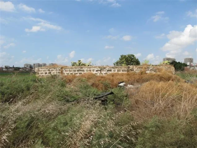
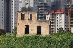
When the site was documented by researchers, part of it consisted of vacant land. Olive trees remained in other areas, alongside cypress and eucalyptus trees planted by residents of the surrounding Israeli localities. Few identifiable traces of the village houses could be discerned. Apartment buildings and a small park had been constructed on the surrounding land.
Sources
- Interactive Encyclopedia of the Palestine Question: “Kafr ‘Ana”, Institute for Palestine Studies.
- Palestine Remembered: “Kafr ‘Ana, Jaffa”.
- Walid Khalidi, ed., All That Remains: The Palestinian Villages Occupied and Depopulated by Israel in 1948, Institute for Palestine Studies, 1992.
- Bibliographic record for Walid Khalidi’s All That Remains, Google Books.
- Government of Palestine, Village Statistics, April 1945.
- Our Palestine: “The Depopulated Village of Kafr ‘Ana”.
Photo gallery


Photos from the village's people
Photos sent in by visitors and published after review.
Add a photo of this village
Log in to add photos of this village.
Other villages from Jaffa
 Download Our Palestine App
The whole archive in the palm of your hand: depopulated villages, the Nakba, the massacres and Al-Aqsa — free, with no ads to erase the story.
Download Our Palestine App
The whole archive in the palm of your hand: depopulated villages, the Nakba, the massacres and Al-Aqsa — free, with no ads to erase the story.



Comments
No comments yet — be the first to write one.
Add your comment
Name and email are optional. Comments appear after review.