
The depopulated village of Yazur / District of Jaffa
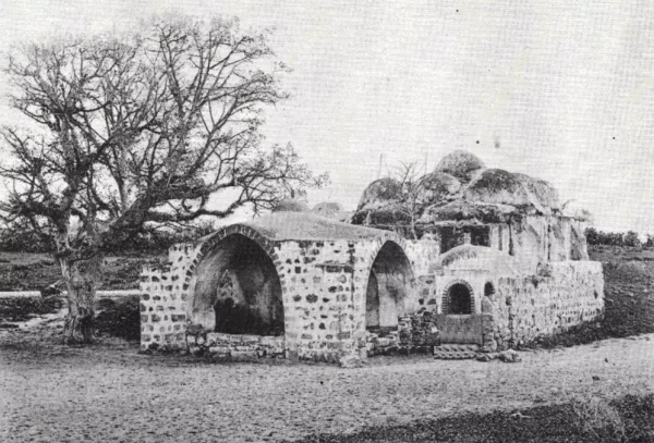
Subdistrict: Jaffa
Population in 1948: 4,675 (estimated)
Date of occupation: 30 April–1 May 1948
Military unit: Haganah forces, principally the Giv‘ati Brigade, during Operation Hametz
Settlement established on traditionally held village land before 1948: Miqwe Yisrael
Settlement established on village land after 1948: Azor. Parts of Holon and its industrial zone later expanded over village lands.
Location of Yazur
Yazur was a Palestinian village in the Jaffa Subdistrict, approximately 6 kilometres east of Jaffa and about 60 kilometres northwest of Jerusalem. It stood around 25 metres above sea level on level ground in the central coastal plain. The village’s built-up area covered 87 dunams.
The Jaffa–Jerusalem road and the railway linking Jaffa with Lydda passed nearby, giving Yazur direct connections with Jaffa, al-Ramla, and other towns of the interior.
Boundaries of Yazur
Yazur was surrounded by the following villages and localities:
- Salama to the north.
- Jaffa to the northwest, west, and southwest.
- Qabbaniyat to the south.
- Bayt Dajan to the southeast.
- Saqiya to the east.
- Al-Khayriyya to the northeast.

Population and Built Environment
In the late nineteenth century, Yazur was described as an adobe-built village surrounded by scattered gardens and wells, with a domed shrine. The modern village was divided into four quarters, one for each of its four principal clans. Houses were built of stone or adobe brick mixed with straw and were grouped around shared courtyards known as ahwash.
In 1944/45, Yazur had 4,030 residents: 4,010 Muslims and 20 Christians. The 1931 census recorded 419 occupied houses. The figure of 838 houses for 1948 is a later estimate rather than an official census count.
Economic Life in Yazur
Agriculture formed the backbone of Yazur’s economy. Citrus cultivation was especially important and occupied 6,723 dunams across Arab- and Jewish-owned land in 1944/45. The village’s many artesian wells supported irrigated agriculture. Olive trees occupied 30 dunams, while cereals were cultivated on 2,325 dunams across all ownership categories.
During the Second World War, villagers also began raising Holstein cattle for dairy production. Contemporary local estimates valued annual milk revenue at approximately 25,000 Palestinian pounds and total village income at around 140,000 Palestinian pounds, most of it generated by citrus farming; these figures should be treated as contemporary estimates rather than official statistics.
Landownership in Yazur
| Owner | Area (dunams)* |
|---|---|
| Palestinian Arab | 9,742 |
| Jewish | 1,428 |
| Public land | 637 |
| Total | 11,807 |
Land Use in Yazur, 1944/45
| Land use | Palestinian Arab (dunams)* | Jewish (dunams)* |
|---|---|---|
| Citrus groves | 6,272 | 451 |
| Plantations and irrigable land | 1,689 | 80 |
| Olive groves (included within cultivated land) | 30 | 0 |
| Cereals | 1,461 | 864 |
| Built-up area | 87 | 0 |
| Total cultivable land | 9,422 | 1,395 |
| Non-cultivable land | 233 | 33 |
* One dunam equals 1,000 square metres (approximately 0.247 acres). The full village total also included 637 dunams of public land, bringing total non-cultivable land across all ownership categories to 903 dunams.
Population of Yazur by Year
| Year | Population* |
|---|---|
| 1596 | 275 (estimated from Ottoman tax records) |
| 1922 | 1,284 |
| 1931 | 2,337 |
| 1945 | 4,030 |
| 1948 | 4,675 (estimate) |
| Refugees and descendants, 1998 | 28,708 (estimate) |
Number of Houses in Yazur
| Year | Number of houses |
|---|---|
| 1931 | 419 |
| 1948 | 838 (estimate) |
Education in Yazur
Yazur had two elementary schools. The boys’ school opened in 1920 and had 430 pupils in 1947. It occupied 27 dunams, much of which was used for agricultural training, and had its own artesian well. The girls’ school opened in 1933 and enrolled about 160 pupils in 1947. The original draft’s figure of 106 girls conflicts with the standard village reference and has therefore been corrected. A village library reportedly held 90 books.
Archaeological and Religious Sites
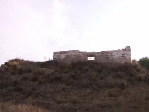
Yazur contained remains from several historical periods. Two Chalcolithic burial caves provide some of the earliest evidence of settlement at the site. The village was mentioned as Azuru in Assyrian records. Remains of the Crusader fortress known as Casel des Plains, associated with Richard I’s campaign in 1191, survived on a hill within the village. A former Crusader church was later incorporated into the village mosque. Yazur also contained the domed shrine of Sayyiduna Haydara and another shrine.
The Occupation of Yazur
Yazur endured repeated raids from December 1947 onward. These included bombings, demolitions, mortar fire, and attacks involving armoured vehicles. The village was finally occupied by the Haganah’s Giv‘ati Brigade during Operation Hametz, whose purpose was to seize the villages connecting Jaffa with its hinterland and isolate the city.
Sources differ slightly on the date: several accounts give 30 April 1948, while historian Benny Morris places the fall of the village on 1 May. Arab Liberation Army records indicate that a unit equipped with two field guns had been sent to Yazur but withdrew on 28 April for another engagement. British forces temporarily retained positions overlooking the main road, while the Haganah held the remainder of the village.
Settlements on the Lands of Yazur
Miqwe Yisrael was founded in 1870 on land traditionally associated with Yazur. Azor was established on village land in 1948 and later became part of the industrial and urban area adjoining Tel Aviv and Holon. The source material supports Miqwe Yisrael and Azor by name; the more detailed list of later Holon neighbourhoods in the original draft could not be verified reliably and has therefore been summarized rather than presented as established fact.
Yazur Today
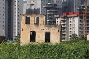
Two shrines remain standing. One is a stone structure whose roof has twelve smaller domes surrounding a larger central dome. Several houses and other buildings also survive; some are occupied or used commercially, while others stand vacant. Modern apartment blocks occupy parts of the site, where cypress, fig, and sycamore trees and cactus also grow. Surrounding land is cultivated.
Editorial and Factual Corrections
- The occupation date is presented as 30 April–1 May 1948 because credible sources differ by one day.
- The responsible formation is identified as the Giv‘ati Brigade, not merely unspecified Haganah units.
- The incorrect image caption referring to Bayt Dajan was replaced with Yazur.
- The incorrect internal link that pointed from Bayt Dajan to the Salama article was removed.
- The girls’ school enrollment was corrected to about 160 pupils in 1947, in accordance with the standard village reference.
- Palestinian-owned non-cultivable land was corrected to 233 dunams: the figure of 870 includes 637 dunams of public land.
- The 1948 population and housing figures, and the 1998 refugee projection, are clearly identified as estimates.
Sources
- PalQuest: Yazur, Interactive Encyclopedia of the Palestine Question.
- PalQuest: Operation Hametz.
- Palestine Remembered: Yazur, Jaffa, drawing principally on Walid Khalidi’s All That Remains.
- Government of Palestine, Census of Palestine, 1922 and Census of Palestine, 1931.
- Government of Palestine, Department of Statistics, Village Statistics, April 1945.
Photo gallery


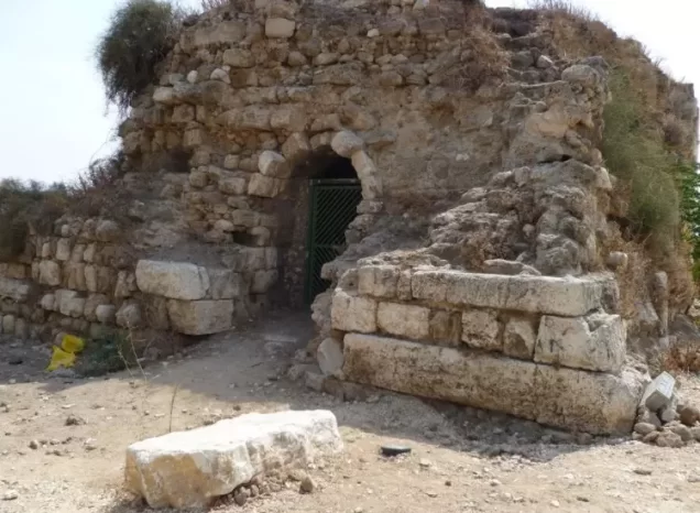


Photos from the village's people
Photos sent in by visitors and published after review.
Add a photo of this village
Log in to add photos of this village.
Other villages from Jaffa
 Download Our Palestine App
The whole archive in the palm of your hand: depopulated villages, the Nakba, the massacres and Al-Aqsa — free, with no ads to erase the story.
Download Our Palestine App
The whole archive in the palm of your hand: depopulated villages, the Nakba, the massacres and Al-Aqsa — free, with no ads to erase the story.



Comments
No comments yet — be the first to write one.
Add your comment
Name and email are optional. Comments appear after review.