
The depopulated village of 'Amqa / District of Akka (Acre)
About the depopulated village of 'Amqa
- District
- Akka (Acre)
- Date 'Amqa was occupied
- 10 July 1948
- Population in 1948
- 1,438
- Military operation
- Operation Dekel
- Brigade that carried it out
- The Seventh Brigade، The Carmeli Brigade
- Distance from the governorate centre
- 11 km northeast of Acre
- Elevation above sea level
- 100 m
- Cause of displacement
- Direct military assault by Israeli occupation forces, with an artillery bombardment during which most inhabitants probably left
- Extent of destruction
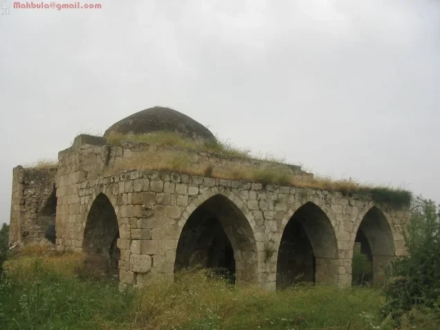
- 'Amqa was mostly destroyed with the exception of the its school and its mosque.
- Ethnic cleansing
- 'Amqa was mostly ethnically cleansed with the exception of its Druze inhabitants who still live nearby.
- Settlements built on the built-up area of 'Amqa after 1948
- 'Amqa (1949, established by the Jewish National Fund on village land directly north of the village site)
Hover a dot to read the village name, or click to open its card.
Borders of the depopulated village of 'Amqa
'Amqa: A Depopulated Palestinian Village in the Acre District
'Amqa was a depopulated Palestinian village in the Acre District, located approximately 11 kilometers northeast of Acre on a rocky, uneven hill where the slopes of western Lower Galilee met the Acre plain. Its average elevation was approximately 100 meters above sea level.
- Subdistrict
- Acre
- Distance from district center
- 11 km northeast of Acre
- Average Elevation
- 100 m above sea level
- Population in 1931
- 894 according to Khalidi/PalQuest; the 1931 census table used in the article records 895 (460 males and 435 females)
- Number of Houses in 1931
- 212
- Population in 1944/1945
- 1,240
- Estimated Population in 1948
- About 1,438 – a later demographic estimate, not an official census
- Total Land Area in 1945
- 6,068 dunams – of which 6,060 dunams Arab-owned and 8 dunams public land
- Attack and Depopulation
- The village came under attack on 10–11 July 1948, during the first stage of Operation Dekel, when units from the Seventh (Sheva') Brigade and the First Battalion of the Carmeli Brigade bombarded it with artillery; it was one of the first villages to be occupied in the area. Most inhabitants probably left during the barrage, but some appear to have remained: Nafez Nazzal quotes eyewitnesses who said that the shelling continued into the second truce and that a woman was injured in the village as late as 31 July 1948.
- Final Israeli Control
- 10–11 July 1948, in the first stage of Operation Dekel
- Military Operation
- Operation Dekel
- Military Unit
- Units from the Seventh (Sheva') Brigade and the First Battalion of the Carmeli Brigade
- Cause of Depopulation
- Direct military assault by Israeli occupation forces, with an artillery bombardment during which most inhabitants probably left
- Settlements Documented on Village Lands
- 'Amqa, a settlement established by the Jewish National Fund in 1949 on village land directly north of the village site
The Government of Palestine's 1944/1945 statistics recorded a population of 1,240 and a total land area of 6,068 dunums. During the Nakba and the occupation of Palestine in 1948, the village was subjected to artillery bombardment and occupied by forces drawn from the Sheva' (Seventh) Brigade and the First Battalion of the Carmeli Brigade on 10–11 July, during the first phase of Operation Dekel. Most inhabitants left during the assault, although Palestinian testimony indicates that some people remained in or returned to the village afterward.
Location of 'Amqa
- The village was approximately 11 kilometers northeast of Acre.
- Its average elevation was about 100 meters above sea level.
- It stood on a rocky, uneven hill where the slopes of western Lower Galilee met the Acre plain.
- A secondary road connected it with the coastal highway leading to Acre.
- Other roads and dirt tracks connected the village with neighboring communities.
- Its lands bordered al-Ghabisiyya to the north and northwest, Khirbat Jiddin to the northeast, Abu Sinan to the south and east, and Kuwaykat to the west.
The Name and History of 'Amqa
The origin of the name 'Amqa is not conclusively established. Walid Khalidi suggests a possible connection with a Semitic word meaning valley, while Palestinian local documentation relates the name to a Phoenician or broader Semitic root associated with a valley, plain, or lowland. The derivation is therefore best treated as uncertain.
During the Roman period, a settlement at the same site was known as Kefar Amqa. Crusader sources later referred to the locality as Amca.
The status of the site during the early Islamic period remains insufficiently established in the archaeological sources summarized by Khalidi.
In 1596, 'Amqa was a village in the nahiya of Acre within the liwa' of Safad and had an estimated population of approximately 215.
The villagers paid taxes on wheat, barley, olives, cotton, fruit, goats, beehives, and other forms of production.
In the mid-eighteenth century, Arab traveler Mustafa al-Bakri al-Siddiqi recorded that he prayed in 'Amqa while traveling through the region after visiting the fortress of Atlit.
The Built Environment of 'Amqa
In the late nineteenth century, 'Amqa was described as a stone-built village on a slight rise in a valley, surrounded by olive and fig trees and cultivated land.
Its population at the time was estimated at approximately 300.
The village houses were principally constructed from local stone, while cultivated fields, orchards, and pasture surrounded the built-up area.
The built-up area covered approximately 36 dunums according to the 1944/1945 statistics.
Population of 'Amqa
The 1922 Census of Palestine recorded 724 inhabitants in 'Amqa, including 722 Muslims and two Christians.
The official 1931 Census of Palestine recorded 895 inhabitants: 460 males and 435 females, all Muslims, living in 212 occupied houses.
A source discrepancy should be noted here. PalQuest and Palestine Remembered give 894 inhabitants for 1931, whereas the official census table records 895. This article therefore uses the official census figure.
In the Government of Palestine's 1944/1945 statistics, the population was 1,240 and was recorded as Muslim.
The figures of 1,438 inhabitants for 1948 and 8,833 refugees for 1998 published by Palestine Remembered are later demographic estimates rather than official censuses conducted in those years.
Population of 'Amqa
- 1596About 215Historical estimate based on Ottoman records
- Late 19th centuryAbout 300Historical estimate
- 1922724Official census: 722 Muslims and two Christians
- 1931895Official census; all Muslims, living in 212 occupied houses
- 1944/19451,240Government of Palestine statistics
- 19481,438Later estimate published by Palestine Remembered
- 19988,833Later refugee-population estimate published by Palestine Remembered
Number of Houses in 'Amqa
The 1931 Census of Palestine recorded 212 occupied houses in 'Amqa.
The figure of 341 houses for 1948 published by Palestine Remembered is a later estimate rather than the result of an official census conducted that year.
Number of Houses in 'Amqa
- 1931212Official census
- 1948341Later estimate published by Palestine Remembered
Education in 'Amqa
The Ottoman authorities established a school in 'Amqa in 1887.
The Palestinian Villages Encyclopedia records that the school was expanded during the British Mandate period to three rooms and that instruction extended through the fourth grade.
Pupils who wished to continue their education beyond that level attended the school in neighboring Kafr Yasif.
The Mosque of 'Amqa
The mosque was one of the principal landmarks of 'Amqa and is among the few village buildings known to have survived the destruction of most of the settlement.
Palestinian local documentation suggests that it may date from an early phase of the Ottoman period, although its precise construction date is not sufficiently established in the principal sources.
The mosque was constructed from local stone, surmounted by a dome, and its northern façade was distinguished by three large entrances topped by pointed arches.
Water Sources in 'Amqa
Palestinian local documentation states that 'Amqa did not have permanent springs within the village itself. Residents therefore dug wells and constructed cisterns to collect rainwater for daily use.
During the summer, villagers also depended on water sources in nearby areas and villages, including al-Kabri and Kuwaykat.
Land Ownership in 'Amqa
The Government of Palestine's 1944/1945 statistics recorded a total land area of 6,068 dunums for 'Amqa, with no Jewish land ownership recorded.
The Arabic Palestine Remembered table uses the categories “Palestinian,” “Transferred to Zionists,” and “Masha'.” These terms are retained below as that source's terminology. The official Government of Palestine categories for the same figures were “Arab” and “Public.”
Land Ownership in 'Amqa, 1944/1945, Using Palestine Remembered Terminology
- Palestinian6,060 dunums100%
- Transferred to Zionists0 dunums0%
- Masha' (source terminology)8 dunums<1%
Land Use in 'Amqa in 1944/1945
A total of 4,996 dunums was cultivated or classified as cultivable, all of it recorded as Arab land.
Cereals occupied 3,348 dunums, while plantations and irrigable land covered 1,648 dunums.
The built-up area occupied 36 dunums. Non-cultivable land totaled 1,036 dunums, consisting of 1,028 dunums of Arab land and 8 dunums of public land.
Land Use in 'Amqa According to the 1944/1945 Statistics
- Arab
- Jewish
- Public
- Plantations and Irrigable Land1,648 dunums
- Cereals3,348 dunums
- Built-up Area36 dunums
- Non-Cultivable Land1,036 dunums
Palestine Remembered separately records approximately 1,884 dunums planted with olive trees. This figure is presented as supplementary agricultural information and is not added again to the official land-use categories.
Economic Life in 'Amqa
Most inhabitants of 'Amqa depended on agriculture, animal husbandry, and related rural activities. Villagers also produced milk, dairy products, and cheese that were sold in Acre and neighboring villages.
Cereals were among the principal crops, alongside olives, figs, cotton, fruit, and other agricultural produce.
Plantations and irrigated fields occupied a substantial share of the village's cultivated land, while other areas were used for grazing.
Ottoman tax records indicate that as early as the sixteenth century the local economy included wheat, barley, olives, cotton, fruit, goats, and beehives.
Archaeological Remains in 'Amqa
'Amqa occupied an archaeological site containing architectural fragments, cisterns, and tombs that reflected the long history of settlement in the area.
Three khirbas in the vicinity also contained building foundations, finely dressed building stones, presses, and a water cistern.
Palestinian local documentation identifies sites including Khirbat al-Hanbaliyya, Khirbat al-Muna, and Bi'r Iklil, where remains of buildings, reservoirs, tombs, presses, and other archaeological features were recorded.
Operation Dekel
The occupation of 'Amqa was connected with Operation Dekel, an Israeli military offensive that began on the night of 8 July 1948 and continued until 18 July during the renewed fighting between the first and second truces.
The first stage of the operation sought to capture a chain of Palestinian villages along a north-south axis in the western Galilee hills, extending from the al-Kabri area in the north through al-Birwa and toward Shafa 'Amr in the south.
The attacking formations in this phase included forces from the Sheva' Brigade, also known as the Seventh Brigade, and the First Battalion of the Carmeli Brigade.
This initial phase expanded the coastal area of the Acre District under Zionist control. Operation Dekel subsequently extended across large parts of Lower Galilee, including Nazareth.
The Occupation and Depopulation of 'Amqa
Palestinian villages around 'Amqa had already been subjected to attacks and displacement before fighting directly reached the village, and displaced people from neighboring communities began seeking refuge in 'Amqa in May 1948.
On 10–11 July 1948, during the first phase of Operation Dekel, units drawn from the Sheva' Brigade and the First Battalion of the Carmeli Brigade advanced toward 'Amqa and subjected the village to artillery bombardment.
'Amqa was among the first villages occupied during this phase. Palestine Remembered gives 10 July as the date of occupation, while Walid Khalidi and PalQuest describe the attack as taking place on 10–11 July.
Most villagers probably left during the artillery barrage, but the available evidence indicates that the village was not completely empty immediately after the initial assault.
Walid Khalidi cites Palestinian historian Nafez Nazzal, who recorded eyewitness testimony stating that shelling continued into the period of the second truce and that a woman was wounded in 'Amqa as late as 31 July 1948. This indicates that some inhabitants or returnees were still present after the first occupation.
Occupation and Depopulation Chronology
- May 1948
Refugees from neighbouring villages seek shelter in the village
People from villages near 'Amqa began to seek refuge in the village, the Haganah having begun to attack Palestinian coastal villages as early as December 1947, while the fighting had not yet reached 'Amqa itself.
- 8 July 1948
Beginning of the military operation
Operation Dekel began on the night of 8 July; its first phase targeted a string of villages along a north–south axis in the western Galilean hills, with units from the Seventh (Sheva') Brigade and the First Battalion of the Carmeli Brigade.
- 10–11 July 1948
Shelling of the village
Units from the Seventh (Sheva') Brigade and the First Battalion of the Carmeli Brigade advanced and bombarded the village with artillery; most inhabitants probably left during the barrage.
- 10–11 July 1948
Final occupation
'Amqa was one of the first villages in the area to be occupied by Israeli occupation forces during the first stage of Operation Dekel; Khalidi dates its capture to 10–11 July in his entry on neighbouring Khirbat Jiddin.
- During the second truce – until 31 July 1948
Continued shelling of the village
Some inhabitants appear to have remained in the village: Palestinian historian Nafez Nazzal quotes eyewitnesses who said that the shelling of 'Amqa continued into the second truce, and that a woman was injured in the village as late as 31 July.
- 20 August 1948
Plan for a settlement on the village site
The Jewish National Fund submitted a plan according to which 'Amqa, together with thirty-one other villages, would be the site of new Jewish settlements.
- 1949
Settlement on village lands
The Jewish National Fund established the settlement of 'Amqa on village land, directly north of the village site.
A Note on the Religious Identity of 'Amqa's Population
One Israeli account cited by Walid Khalidi describes 'Amqa as a Druze village. This characterization conflicts with the official Mandate-era censuses as well as Khalidi's own description of the community.
The 1922 census recorded 722 Muslims and two Christians, the 1931 census recorded an entirely Muslim population, and the 1944/1945 population was recorded as 1,240 Muslims.
This article therefore follows the official census evidence and does not classify 'Amqa as a Druze village.
Israeli Settlement on 'Amqa's Lands
On 20 August 1948, the Jewish National Fund submitted a plan proposing new Jewish settlements on the lands of 'Amqa and thirty-one other depopulated Palestinian villages.
In 1949, the settlement of Amka was established on village land immediately north of the former Palestinian village site.
The Site of 'Amqa After the Nakba
According to Walid Khalidi's historical field description, wild grasses covered the former village site and only the school and mosque remained among its principal buildings.
The mosque was a stone structure surmounted by a dome. Its northern façade was defined by three large pointed-arched entrances, while its walls were cracked in several places and some stones had fallen away.
The school had a sloping roof, and new annexes had been attached to it. At the time of Khalidi's survey, the complex was being used as a warehouse.
The surrounding land was used for animal grazing.
This description derives from fieldwork conducted for Walid Khalidi's All That Remains and should not necessarily be treated as an updated field survey of the site today.
Sources
- PalQuestPalQuest – Interactive Encyclopedia of the Palestine Question: 'Amqa
- PalQuestPalQuest – Interactive Encyclopedia of the Palestine Question: Operation Dekel
- Palestine RememberedPalestine Remembered: 'Amqa – Acre District
- palqura.comPalestinian Villages Encyclopedia: 'Amqa
- pal48.psFilastunna: The Depopulated Village of 'Amqa
- pcbs.gov.psPalestinian Central Bureau of Statistics: Historical Censuses and Reports
Photo gallery


Photos from the village's people
Photos sent in by visitors and published after review.
Add a photo of this village
Log in to add photos of this village.
Other villages from Akka (Acre)

More from the archive



 Download Our Palestine App
The whole archive in the palm of your hand: depopulated villages, the Nakba, the massacres and Al-Aqsa — free, with no ads to erase the story.
Download Our Palestine App
The whole archive in the palm of your hand: depopulated villages, the Nakba, the massacres and Al-Aqsa — free, with no ads to erase the story.



Comments
No comments yet — be the first to write one.
Add your comment
Name and email are optional. Comments appear after review.