
The depopulated village of Al-Haram (Sayyidna 'Ali) / District of Jaffa

Al-Haram (Sayyidna 'Ali)
About the depopulated village of Al-Haram (Sayyidna 'Ali)
- District
- Jaffa
- Date Al-Haram (Sayyidna 'Ali) was occupied
- 03 February 1948
- Population in 1948
- 603
- Distance from the governorate centre
- 16 km north of Jaffa
- Elevation above sea level
- 25 m
- Cause of displacement
- Fear of Jewish attack, or of being caught in the fighting
- Extent of destruction
- al-Haram was mostly destroyed with the exception of few houses and the village cemetery.
- Ethnic cleansing
- al-Haram (also known by Sidna Ali) inhabitants were intimidated into fleeing by the Haganah on February 3rd, 1948.
- Settlements built on the land of Al-Haram (Sayyidna 'Ali) before 1948
- Kefar Shemaryahu, established in 1937 southeast of the village site on what had traditionally been village land; and Rishpon, built in 1936 on the northern border of the village lands
Hover a dot to read the village name, or click to open its card.
Borders of the depopulated village of Al-Haram (Sayyidna 'Ali)
al-Haram (Sayyiduna 'Ali): A Depopulated Palestinian Village in the Jaffa District
al-Haram, also known as Sayyiduna 'Ali, was a Palestinian village in the Jaffa District, situated on a low sandstone hill overlooking the Mediterranean coast approximately 16 kilometres north of Jaffa, at an average elevation of about 25 metres above sea level. Its Arab population reached 520 in the 1944/1945 statistics. The villagers began leaving amid fear and fighting during the early months of 1948, while the detailed Palestinian reference account indicates that Zionist forces probably secured final military control shortly before the end of the British Mandate on 15 May 1948.
- Subdistrict
- Jaffa
- Distance from district center
- 16 km north of Jaffa
- Average Elevation
- 25 m above sea level
- Population in 1931
- 333
- Number of Houses in 1931
- 83
- Population in 1944/1945
- 520 – Arab inhabitants; the statistical unit totalled 880, including 360 Jews
- Estimated Population in 1948
- About 603 – a later demographic estimate, not an official census
- Total Land Area in 1945
- 8,065 dunams
- Attack and Depopulation
- The available sources document no specific attack on the village; Khalidi states that Zionist forces probably seized it some time before the end of the British Mandate on 15 May 1948, when they controlled the whole coastal area between Haifa and Tel Aviv.
- Final Israeli Control
- Probably some time before 15 May 1948, according to Khalidi; the available sources give no exact day.
- Settlements Documented on Village Lands
- Kefar Shemaryahu, established in 1937 southeast of the village site on what had traditionally been village land; and Rishpon, built in 1936 on the northern border of the village lands
Location
al-Haram stood on a low sandstone hill on the central coastal plain overlooking the Mediterranean Sea.
The village was approximately 16 kilometres north of Jaffa and had an average elevation of about 25 metres above sea level.
Its coastal location allowed the inhabitants to combine agriculture with fishing.
The Village Name and the Shrine of Sayyiduna 'Ali
The village was known both as al-Haram and Sayyiduna 'Ali, after the shrine and mosque that formed its principal religious landmark.
Some modern reference texts identify the saint as “al-Hasan ibn 'Ali,” who died in 1081 and was descended from Caliph 'Umar ibn al-Khattab. This formulation is historically inconsistent with the well-known Hasan ibn 'Ali.
More detailed local Palestinian documentation instead identifies the saint as Shaykh 'Ali ibn 'Alil, also known as Ibn 'Alim, who is said to have died in 474 AH/1081 CE and to have been descended from Caliph 'Umar ibn al-Khattab.
This article therefore uses the name 'Ali ibn 'Alil when referring to the figure associated with the shrine, while noting the discrepancy in some secondary references.
The shrine drew visitors from across Palestine, particularly during the summer, for prayer, religious observances, and social gatherings.
Architecture and Public Facilities
The houses of al-Haram were closely clustered and constructed of stone or adobe brick.
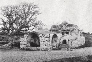
The mosque and shrine formed the principal religious complex of the village and included colonnaded and arched porticoes, as well as a minaret.
Most inhabitants of the village were Muslims.
The Arab built-up area covered approximately 18 dunams in the 1944/1945 statistics.
Education
A boys' elementary school was established in al-Haram in 1921.
By the mid-1940s, enrollment had reached 68 pupils.
Local Palestinian documentation additionally records two teachers, a school library containing approximately 132 books, and about 110 men in the village who were literate. These details derive primarily from local documentation and are not all reproduced in the same detail in the principal reference sources.
Population
Local historical documentation gives an estimate of approximately 341 inhabitants in 1904.
The 1922 census recorded 172 inhabitants.
By the 1931 census, the population had increased to 333 people living in 83 houses.
The 1944/1945 statistics require a distinction between the Arab village population and the broader statistical unit. They recorded 520 Arabs and 360 Jews, producing a total of 880.
The Palestinian Arab village itself therefore had 520 inhabitants, not 880.
The figure of approximately 603 Arabs in 1948 is a later estimate. Palestine Remembered estimates the number of refugees and their descendants at 3,704 in 1998.
Population of al-Haram
- 1904About 341Local historical estimate
- 1922172Official census
- 1931333Official census
- 1944/1945520 ArabsArab village population
- 1944/1945880Statistical-unit total: 520 Arabs + 360 Jews
- 1948About 603 ArabsLater estimate
- 19983,704Estimate of refugees and their descendants
Number of Houses
The 1931 census recorded 83 houses in al-Haram.
The figure of approximately 150 houses in 1948 is a later estimate rather than an official census count.
Land of al-Haram
According to the 1944/1945 statistics, al-Haram had a total land area of 8,065 dunams.
Arab ownership amounted to 2,681 dunams, Jewish ownership to 4,745 dunams, while 639 dunams were classified as public land.
Land Ownership in al-Haram in 1944/1945
- Arab ownership2,681 dunums33%
- Jewish ownership4,745 dunums59%
- Public land639 dunums8%
Agriculture and Economic Life
Agriculture formed the mainstay of al-Haram's economy, alongside fishing due to the village's coastal location.
According to the 1944/1945 statistics, 136 Arab-owned dunams were devoted to citrus and bananas.
Irrigated and plantation land covered 301 dunams in total: 256 Arab-owned dunams and 45 Jewish-owned dunams.
Cereal cultivation covered 6,387 dunams: 2,096 Arab-owned dunams, 4,057 Jewish-owned dunams, and 234 dunams of public land.
Palestine Remembered gives 2,330 dunams in its Arab cereal column, but this figure effectively combines 2,096 Arab-owned dunams with 234 dunams of public land. This article follows the detailed ownership breakdown in PalQuest.
Local sources also record approximately 137 dunams planted with olive trees. This represents a crop category within cultivated land and should not be added separately to the overall land-use total.
Land Use in al-Haram in 1944/1945, in Dunams
- Arab
- Jewish
- Public
- Citrus and bananas136 dunums
- Irrigated and plantation land301 dunums
- Cereals6,387 dunums
- Built-up area18 dunums
- Uncultivable land1,223 dunums
Khirbat Arsuf and the Archaeological Landscape
Khirbat Arsuf lies approximately 800 metres north of al-Haram and represents an archaeological site occupied during multiple historical periods.
Excavations conducted in 1977 and 1982 uncovered the remains of a market dating to the early Islamic period.
The archaeological history of the site extends from approximately the fifth century BCE to the sixteenth century CE.
During the Hellenistic period it was known as Apollonia, while the Crusaders later built a fortress there known as Arsur.
The name Arshuf also appears in sixteenth-century Ottoman tax records.
In April 1265, the Mamluk sultan al-Zahir Baybars captured Arsuf during his campaigns against Crusader strongholds on the Palestinian coast.
The modern village of al-Haram appears to have developed after the Arsuf site was abandoned sometime in the seventeenth century, around the shrine and mosque of Sayyiduna 'Ali.
The Nakba and the Depopulation of al-Haram
Palestinian sources differ over the chronology of the villagers' departure and the final military occupation of al-Haram.
Palestine Remembered's summary table gives 3 February 1948 and associates the villagers' departure with fear of a Zionist attack or of being caught in the fighting.
The detailed account transmitted from Walid Khalidi by PalQuest and Palestine Remembered, however, states that Zionist forces probably seized al-Haram shortly before the end of the British Mandate on 15 May 1948, by which time most of the coastal strip between Haifa and Tel Aviv had come under Zionist control.
The most cautious interpretation is therefore not to treat 3 February as a securely documented date of final military occupation. It can instead be associated with an early stage of depopulation, while final military control was established later, probably before 15 May.
The principal reference sources reviewed do not identify a specific named military operation, brigade, or battalion as conclusively responsible for the capture of al-Haram. This article therefore does not assign the occupation to an undocumented unit.
Occupation and Depopulation Chronology
- 1936–1937
Settlement on village lands
The settlement of Rishpon was built in 1936 on the northern border of al-Haram's lands, and Kefar Shemaryahu was established in 1937 southeast of the village site, on what had traditionally been village land.
- Before 15 May 1948 (probably)
Final occupation
Khalidi states that Zionist forces probably seized al-Haram some time before the end of the British Mandate, when they controlled the whole coastal area between Haifa and Tel Aviv. The available sources give no exact day and name no operation or unit.
Settlements and Urban Expansion on al-Haram's Lands
Rishpon
Rishpon was established in 1936 on the northern boundary of al-Haram's lands.
Kefar Shemaryahu
Kefar Shemaryahu was established in 1937 southeast of the village site, on land traditionally regarded as belonging to al-Haram.
Herzliya
Herzliya existed before the Nakba and therefore should not be described as having been established on the ruins of al-Haram after 1948.
Its later urban expansion, however, came to encompass the former village site and the area surrounding the Sayyiduna 'Ali mosque.
- 1936Rishpon
Established on the northern boundary of al-Haram's lands
- 1937Kefar Shemaryahu
Established southeast of the site on land traditionally belonging to al-Haram
- Before 1948Herzliya
Later urban expansion encompassed the former village site and the Sayyiduna 'Ali mosque area
al-Haram After the Nakba
According to the field documentation relied upon by Walid Khalidi, the shrine of Sayyiduna 'Ali, several houses, and the cemetery survived the destruction of the village.
The shrine is a substantial architectural complex that was partially renovated and includes arched colonnaded porticoes and a minaret rising above one of its buildings.
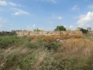
The ruined foundations of Palestinian houses remain visible nearby, while several older houses also survived.
The Palestinian cemetery overlooks the Mediterranean and, according to Khalidi's documentation, part of it was used as a parking area.
Later Palestinian local documentation states that the Sayyiduna 'Ali mosque was restored and returned to use for Muslim prayer, attracting Palestinian worshippers from surrounding communities.
Khalidi's field description should therefore be distinguished from the mosque's later condition following restoration and renewed religious use.
Sources
- PalQuest – Interactive Encyclopedia of the Palestine Question: al-Haram.
- PalQuest: al-Haram.
- Palestine Remembered: al-Haram, Jaffa District.
- Walid Khalidi, All That Remains: al-Haram, as reproduced by Palestine Remembered.
- Local Palestinian documentation on al-Haram and the Sayyiduna 'Ali shrine.
- Local Palestinian documentation on the shrine of 'Ali ibn 'Alil.
- Walid Khalidi, All That Remains, entry on al-Haram.
- Government of Palestine, censuses of 1922 and 1931.
- Government of Palestine, Department of Statistics, Village Statistics, 1945.
Photo gallery


Photos from the village's people
Photos sent in by visitors and published after review.
Add a photo of this village
Log in to add photos of this village.
Other villages from Jaffa
More from the archive
 Download Our Palestine App
The whole archive in the palm of your hand: depopulated villages, the Nakba, the massacres and Al-Aqsa — free, with no ads to erase the story.
Download Our Palestine App
The whole archive in the palm of your hand: depopulated villages, the Nakba, the massacres and Al-Aqsa — free, with no ads to erase the story.



Comments
No comments yet — be the first to write one.
Add your comment
Name and email are optional. Comments appear after review.