
The depopulated village of al-Khayriyya / District of Jaffa
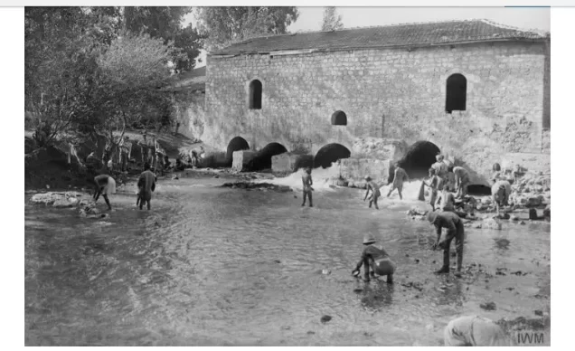
al-Khayriyya
About the depopulated village of al-Khayriyya
- District
- Jaffa
- Date al-Khayriyya was occupied
- 29 April 1948
- Population in 1948
- 1,647
- Military operation
- Operation Bi'ur Hametz
- Brigade that carried it out
- Alexandroni Brigade
- Distance from the governorate centre
- 7.5 km east of Jaffa
- Elevation above sea level
- 25 m
- Cause of displacement
- Direct military assault by Zionist forces (the Haganah's Alexandroni Brigade) in the course of Operation Hametz
- Extent of destruction
- al-Khayriyya was mostly destroyed with the exception of few houses and one of the village schools.
- Ethnic cleansing
- al-Khayriyya inhabitants were intimidate by the Haganah into fleeing sometime in April 1948, and in early May many villagers were interested in coming back and accepting Jewish rule, but this peaceful overture was rejected by the Haganah.
- Settlements built on the land of al-Khayriyya before 1948
- Kefar Azar (established in 1932 on what was traditionally village land)
- Settlements built on the built-up area of al-Khayriyya after 1948
- Ramat Pinqas (1952) and Ramat Ef'al (1969), on village lands north of the village site
Hover a dot to read the village name, or click to open its card.
Borders of the depopulated village of al-Khayriyya
Al-Khayriyya – A Depopulated Palestinian Village in the Jaffa Subdistrict
Al-Khayriyya was a Palestinian village in the Jaffa Subdistrict, situated approximately 7.5 km east of the city of Jaffa on the central coastal plain, at an average elevation of about 25 meters above sea level.
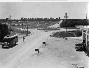
A network of roads passing through and near the village provided easy access to Jaffa, Lydda, Ramla, and the surrounding Palestinian villages.
Al-Khayriyya was occupied during the Nakba and the occupation of Palestine in 1948. On 29 April 1948, units of the Haganah's Alexandroni Brigade attacked and captured the village during Operation Hametz, an offensive aimed at controlling the Palestinian villages east of Jaffa and isolating the city from its hinterland.
- Subdistrict
- Jaffa
- Distance from Jaffa
- 7.5 km east of Jaffa
- Elevation
- 25 m above sea level
- Population in 1931
- 886 – Arab population; the same statistical unit also recorded 28 Jews (total 914)
- Number of Houses in 1931
- 212
- Arab population, 1944/45
- 1,420
- Estimated Population in 1948
- About 1,647 – a later demographic estimate, not an official census
- Total land area
- 13,672 dunams
- Attack and Depopulation
- The village was exposed to hostile military activity for several months before its occupation, including a night raid in which Zionist forces moved into one of its orchards and blew up a house, according to the newspaper Filastin (12 February 1948); units of the Haganah's Alexandroni Brigade, operating from Kefar Azar, then attacked and seized it on 29 April 1948, during Operation Hametz, which was designed to “cleanse the area” and encircle Jaffa.
- Final Israeli Control
- 29 April 1948
- Date of occupation
- 29 April 1948
- Military operation
- Operation Hametz
- Military unit
- The Haganah's Alexandroni Brigade
- Cause of Depopulation
- Direct military assault by Zionist forces (the Haganah's Alexandroni Brigade) in the course of Operation Hametz
- Settlements Documented on Village Lands
- Kefar Azar, established in 1932 on what was traditionally village land; Ramat Pinqas (1952) and Ramat Ef'al (1969), established on village lands north of the village site; the site now lies within the suburbs of the town of Giv'atayim
Location and Surroundings
Al-Khayriyya was built on level ground in the central coastal plain. Roads through and around the village connected its inhabitants with Jaffa, Lydda, Ramla, and neighboring communities.
The lands of Salama lay generally to the west and northwest, Saqiya to the east and southeast, while Yazur and Bayt Dajan lay to the south and southwest. Watercourses separated portions of these village lands.
The al-'Awja River flowed through the broader area to the north on its way toward the Mediterranean, while Wadi al-Musrar formed part of the water system of the surrounding coastal plain.
Name and Earlier History
During the Ottoman period the village was known as Ibn Baraq. During the British Mandate, its Palestinian inhabitants renamed it al-Khayriyya in order to distinguish it from the Zionist settlement of Bnei Beraq, established approximately 6 km north of the village in 1924.
Khalidi associates the site with an ancient settlement recorded in Assyrian sources as Banai Berka. A chronological error appears in some published versions of the village entry, which place Sennacherib in the early eighteenth century BCE. Sennacherib's campaign in Palestine occurred in 701 BCE, in the early seventh century BCE.
In Roman times the site was known as Beneberak, while the Crusaders built a fortification known as Bombrac.
In 1596, under the name Ibn Baraq, the village belonged to the nahiya of Ramla in the liwa' of Gaza and had an estimated population of about 154. Taxes were paid on wheat, barley, fruit, sesame, goats, beehives, and vineyards.
Population of Al-Khayriyya
The official 1922 Census of Palestine recorded 546 inhabitants: 541 Muslims and 5 Christians.
In the 1931 census, the statistical unit contained 914 inhabitants living in 212 occupied houses. This total was not entirely Arab: the census recorded 881 Muslims and 5 Christians—886 Arabs in total—alongside 28 Jews.
By 1944/45, the official Village Statistics recorded 1,420 Arabs: 1,400 Muslims and 20 Christians.
Palestine Remembered later estimated the population at 1,647 in 1948 and the number of refugees and their descendants at 10,116 in 1998. These are retrospective estimates rather than official British Mandate census counts.
- 1596Approximately 154Estimate derived from an Ottoman tax register
- 1922546Official census; 541 Muslims and 5 Christians
- 1931914 totalOfficial census: 886 Arabs and 28 Jews
- 1944/451,420 ArabsOfficial statistics; 1,400 Muslims and 20 Christians
- 19481,647Later Palestine Remembered estimate, not an official census
- 199810,116 refugeesLater estimate of refugees and their descendants
Number of Houses
- 1931212Occupied houses recorded in the official census
- 1948382Later estimate reported by Palestine Remembered
Education in Al-Khayriyya
The village had two schools, one for boys and one for girls.
The boys' school was established in 1920 and had an eight-dunum plot attached to it for agricultural training.
The girls' school was established in 1945. By 1946, the two schools enrolled 183 boys and 69 girls.
Khalidi's pre-1992 field survey recorded one of the two school buildings as still standing at the village site.
Land Ownership in Al-Khayriyya
The total village land area in the 1944/45 statistics was 13,672 dunums. Palestine Remembered presents the simplified ownership categories as follows:
- Palestinian7,182 dunums53%
- Transferred to Zionists5,842 dunums43%
- Communal/Public648 dunums5%
The official Village Statistics use the original categories Arab, Jewish, and Public: 7,182 dunums were classified as Arab, 5,842 as Jewish, and 648 as public land.
Land Use in 1944/45
- Arab
- Jewish
- Public
- Citrus and bananas5,982 dunums
- Plantations and irrigable land1,397 dunums
- Cereals5,492 dunums
- Built-up land26 dunums
- Non-cultivable land775 dunums
Cultivable land totaled 12,871 dunums: 6,989 Arab, 5,842 Jewish, and 40 public dunums.
A commonly reproduced simplified table incorrectly gives 2,395 Arab dunums of cereal land; the detailed PalQuest table gives 2,355. Likewise, the 775 dunums of non-cultivable land consisted of 167 Arab and 608 public dunums rather than belonging entirely to Palestinian private ownership.
Economic Life
Agriculture and livestock raising formed the principal basis of the Palestinian village economy. Citrus cultivation—especially Jaffa oranges—was particularly important, alongside cereals, orchards, and irrigated crops.
In 1944/45, Arab land included 3,359 dunums devoted to citrus and bananas, 2,355 dunums of cereals, and 1,275 dunums of plantations and irrigable land.
Numerous artesian wells supplied irrigation water, while the village's proximity to Jaffa, Lydda, Ramla, and major roads facilitated the marketing of agricultural produce.
Water
Artesian wells were a major water source in al-Khayriyya and were used particularly for the irrigation of citrus groves, orchards, and other cultivated land.
The village landscape was also shaped by Wadi al-Musrar and the wider watercourse system of the central coastal plain.
Military Activity before the Final Occupation
Al-Khayriyya experienced hostile military activity for several months before its final occupation.
On 15 December 1947, the Palestinian newspaper Filastin reported that villagers were digging defensive trenches and organizing guards at the entrances to the village in response to attacks on nearby Salama and al-'Abbasiyya.
On 12 February 1948, Zionist forces entered an orchard belonging to al-Khayriyya under cover of darkness and demolished a house with explosives. No casualties were reported in the newspaper account.
Operation Hametz and the Occupation of Al-Khayriyya
The final occupation of al-Khayriyya occurred during Operation Hametz, an offensive designed to seize Palestinian villages east of Jaffa and along the railway, isolate Jaffa from its Palestinian hinterland, and tighten the encirclement of the city.
The Alexandroni, Kiryati, and Giv'ati brigades participated in the operation. On 29 April 1948, Alexandroni units operating from the Kefar Azar area attacked and captured Saqiya and al-Khayriyya.
Khalidi and PalQuest specifically identify 29 April 1948 as the date on which al-Khayriyya was seized by the Alexandroni Brigade.
The Palestine Remembered statistics header gives 25 April as the occupation date, but its detailed Khalidi-derived narrative also states that the village fell on 29 April. The latter date is therefore retained here.
Khalidi cites a Haganah intelligence report claiming that, shortly after their displacement in early May, some of the villagers wished to return to their homes even under what the report described as “Jewish authority.” They were not permitted to return.
- 15 December 1947
Villagers' defensive preparations
The Palestinian newspaper Filastin reported that the villagers of al-Khayriyya were digging defensive trenches around the village and manning outposts at its entrances, apparently in response to attacks on the nearby villages of Salama and al-'Abbasiyya.
- 12 February 1948 (date of the report)
House blown up in one of the village orchards
The newspaper Filastin reported that Zionist forces had moved into an orchard belonging to the village under cover of night and had blown up a house; no casualties were mentioned.
- 29 April 1948
Beginning of the military operation
The Haganah launched Operation Hametz, which PalQuest dates from 24 April to 13 May 1948, with units from the Alexandroni, Kiryati and Giv'ati Brigades under the command of Dan Epstein, commander of the Alexandroni Brigade, aiming to seize the villages on both sides of the railway linking Jaffa to its Arab hinterland and to isolate the city. Al-Khayriyya was among the villages north of the railway.
- 29 April 1948
Final occupation
Units of the Haganah's Alexandroni Brigade, using Kefar Azar as their base, attacked and captured the villages of Saqiya and al-Khayriyya, one of the cluster of villages east of Jaffa occupied during Operation Hametz, which was designed to “cleanse the area” and encircle Jaffa.
- Early May 1948
Displaced villagers' wish to return
A Haganah intelligence report claimed that the people of al-Khayriyya, shortly after their displacement in early May 1948, expressed a wish to return to their homes and to “accept Jewish authority”, according to the Arabic text of the village entry on PalQuest.
- 1952
Settlement on village lands
The settlement of Ramat Pinqas was established on village lands, north of the village site.
- 1969
Settlement on village lands
The settlement of Ramat Ef'al was established on village lands, north of the village site.
Israeli Settlements on the Lands of Al-Khayriyya
Kefar Azar: Established in 1932 on what Khalidi describes as land traditionally belonging to al-Khayriyya.
Ramat Pinqas: Established in 1952 on village land north of the former site.
Ramat Ef'al: Established in 1969 on al-Khayriyya's lands north of the village site.
Subsequent metropolitan expansion incorporated large areas of al-Khayriyya's land into the urban fabric surrounding Ramat Gan, Giv'atayim, and neighboring localities.
The Hiriya Landfill on Al-Khayriyya's Lands
Parts of al-Khayriyya's lands were later used as a major refuse-disposal area for metropolitan Tel Aviv. The site became known as Hiriya, a name derived from al-Khayriyya.
Over several decades, the landfill developed into a large artificial mountain of waste. It was closed in 1998 following major environmental problems, including groundwater pollution, gas emissions, and hazards caused by birds near the airport flight paths.
The landfill and surrounding area were subsequently subjected to a major rehabilitation program and incorporated into the metropolitan environmental project now known as Ariel Sharon Park.
The wider landfill area should not be treated as identical with every part of the former village's built-up site. Portions of al-Khayriyya's original Palestinian structures survived elsewhere on the village lands.
Al-Khayriyya Today
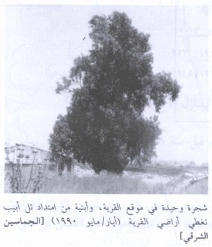
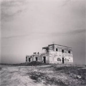
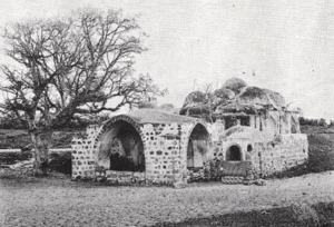
According to the field description published by Walid Khalidi in All That Remains, several Palestinian houses and one of the village's two schools remained standing.
One abandoned house was surrounded by shrubs and wild vegetation and had a simple form with a rectangular doorway, small side windows, and a flat roof. A two-storey house identified as belonging to Ahmad al-Tibi was being used as a store at the time of Khalidi's survey and had rectangular openings and a gabled roof.
Cypress, fig, Christ's-thorn, and orange trees remained around the site. Part of the surrounding land was cultivated, while buildings occupied other sections.
This description derives from fieldwork conducted before the publication of All That Remains in 1992 and should not be treated as direct field verification of every surviving structure in 2026.
Palestine Remembered contains later community documentation, including photographs uploaded in 2025 showing surviving structures associated with the village. Upload dates do not necessarily establish when the photographs were taken, so these materials are best treated as later community documentation rather than a comprehensive current survey.
The part of al-Khayriyya's lands that later became the Hiriya landfill ceased operating as a landfill in 1998 and has since been incorporated into a large environmental rehabilitation and park project known as Ariel Sharon Park.
Sources
- PalQuestPalQuest – Interactive Encyclopedia of the Palestine Question: al-Khayriyya
- PalQuestPalQuest – Operation Hametz
- Palestine RememberedPalestine Remembered – al-Khayriyya, Jaffa
- Palestine RememberedPalestine Remembered – al-Khayriyya entry from All That Remains
- Institute for Palestine StudiesInstitute for Palestine Studies – Walid Khalidi, All That Remains
- pcbs.gov.psGovernment of Palestine – Census of Palestine 1922
- pcbs.gov.psGovernment of Palestine – Census of Palestine 1931
- maktabatsabil.comGovernment of Palestine – Village Statistics 1945: Jaffa Sub-District, Population and Land Ownership
- tandfonline.comJournal of Urban Design – Ariel Sharon Park and the Emergence of Israel's Environmentalism
Photo gallery


Photos from the village's people
Photos sent in by visitors and published after review.
Add a photo of this village
Log in to add photos of this village.
Other villages from Jaffa
More from the archive
 Download Our Palestine App
The whole archive in the palm of your hand: depopulated villages, the Nakba, the massacres and Al-Aqsa — free, with no ads to erase the story.
Download Our Palestine App
The whole archive in the palm of your hand: depopulated villages, the Nakba, the massacres and Al-Aqsa — free, with no ads to erase the story.



Comments
No comments yet — be the first to write one.
Add your comment
Name and email are optional. Comments appear after review.