
Al-Arroub Refugee Camp
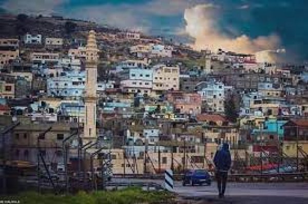
Al-Arroub Refugee Camp
Al-Arroub Refugee Camp: History, Location, Population and Living Conditions
Al-Arroub Camp is one of the 19 official Palestine refugee camps in the occupied West Bank. Set up in in a narrow valley between Bethlehem and Hebron, it was built for Palestinians driven from their villages during the Nakba of 1948. More than seven decades later, its residents still live as refugees, still hold to their right of return, and still face some of the harshest conditions of any camp in the southern West Bank. This guide covers the camp's history, the origin of its name, its geography and size, its population, and its health, economic, social and educational situation.
Quick Facts About Al-Arroub Camp
| Country / Region | Palestine, southern West Bank |
|---|---|
| Governorate | Hebron |
| Nearest cities | Bethlehem (15 km north), Hebron (about 11 km south), Jerusalem (35 km north) |
| Year established | (formal UNRWA operations from ) |
| Area | About 0.24 km² (roughly 238–240 dunums) |
| Registered refugees | 15,936 (UNRWA, ) |
| Population density | About 66,400 people per km² (UNRWA, 2023) |
| Administrative status | Mostly Area B; the stretch along Road 60 is Area C |
| Schools inside the camp | 4 schools, around 1,931 pupils (UNRWA, 2023) |
| Health facilities | 1 UNRWA primary health centre |
| Origin of residents | About 30–35 villages depopulated in 1948, mainly in the former Hebron and Gaza sub-districts |
Note: UNRWA counts refer to refugees registered in the camp. They do not necessarily match the number of people physically living there at any given time.
The Nakba: Why Al-Arroub Camp Exists
The story of Al-Arroub begins with the Nakba (Arabic for "catastrophe"), the mass displacement of Palestinians in . During the war that accompanied the establishment of the State of Israel, roughly 750,000 Palestinians, more than half of the Arab population of Mandate Palestine at the time, were expelled or fled from their homes. Hundreds of towns and villages were emptied, and most were later destroyed or resettled.
The villages in the southern coastal plain and the western Hebron hills were among the last to be depopulated, in the second half of 1948. Their inhabitants moved east into the Hebron mountains, where they first sheltered in caves, orchards, mosques and open fields. With no homes to return to after the 1949 armistice lines were drawn, these families became permanent refugees. Al-Arroub Camp was created to give them shelter.
For the people of the camp, the Nakba is not only a historical event. It is an ongoing condition: each new generation is born a refugee, carries the name of a village it has never seen, and inherits both the loss and the claim to return.
The Right of Return
The right of return is the central political and moral demand of Al-Arroub's residents and of Palestine refugees everywhere. It rests on several foundations in international law:
- UN General Assembly Resolution 194 (), paragraph 11, resolved that refugees wishing to return to their homes and live at peace with their neighbours should be permitted to do so at the earliest practicable date, and that compensation should be paid for the property of those choosing not to return and for loss of or damage to property.
- The Universal Declaration of Human Rights (Article 13) affirms everyone's right to leave any country, including their own, and to return to it.
- UN General Assembly Resolution 3236 () reaffirmed the "inalienable right" of Palestinians to return to their homes and property.
Because this right has never been implemented, refugee status passes from parent to child. UNRWA registers the descendants of male Palestine refugees, which is why the registered population of camps like Al-Arroub keeps growing even though the camp's boundaries have barely changed since 1949.
Israel rejects a return of refugees to its territory, and the issue was deferred to "final status" talks under the Oslo Accords, which never concluded. Inside the camp, the right of return remains part of daily identity: neighbourhoods are often organised by village of origin, and many families still keep the deeds and keys of homes left behind in 1948.
History and Establishment of the Camp
Tents in the valley (1949–1950)
Al-Arroub Camp was established in in an area locally known as Wadi al-Saqi' (وادي الصقيع, "the valley of frost"), named for the cold that settles in the low valley in winter. Refugees first lived in tents supplied by relief organisations, including the International Committee of the Red Cross, which handled emergency aid before the United Nations agency for refugees was set up.
UNRWA takes over (1950)
The UNRWA was created by UN General Assembly Resolution 302 (IV) in December 1949 and began operations in May . That is why many references give 1950 as the camp's founding year, while others give 1949, when the refugees actually settled there. Like other West Bank camps, the land was leased by UNRWA from the Jordanian government, which ruled the West Bank at the time. The refugees do not own the land on which their homes stand.
From tents to concrete shelters
During the 1950s, tents were gradually replaced by small concrete or block rooms, usually one or two rooms per family with shared latrines. Over the decades, families added rooms and then additional floors as they grew, turning the original grid of shelters into the dense, multi-storey urban fabric seen today.
Under Israeli occupation (1967 onward)
Israel occupied the West Bank in the war. The Israeli census conducted that year counted 3,647 people in the camp. Its position directly on the main Jerusalem–Hebron road made Al-Arroub a frequent point of friction during the First Intifada (1987–1993), when the camp's main entrance was fenced and blocked at various times, and again during the Second Intifada (2000–2005).
After the Oslo Accords (1995 onward)
Under the Oslo II Interim Agreement of 1995, most of the camp was classified as Area B (Palestinian civil control, Israeli security control), while the section along Road 60 fell into Area C (full Israeli control). An Israeli military watchtower stands immediately outside the camp.
Origin of the Name "Al-Arroub"
The camp takes its name from the place where it was built: Wadi al-Arroub and the nearby Ein al-Arroub (Al-Arroub spring). The name is far older than the camp. The springs of Wadi al-Arroub have fed water systems to Jerusalem since antiquity, and the neighbouring village is called Shuyukh al-Arroub after the same area.
The name is also spelled Al-Arrub, Arroub, El-Arroub or Al-Aroub in English sources; in Arabic it is written مخيم العروب.
Location and Geography
Al-Arroub Camp lies in the Hebron Governorate in the southern West Bank, on the left (eastern) side of the main Bethlehem–Hebron road (Road 60) when travelling south. Key distances:
- About 15 km south of Bethlehem
- About 11 km north of Hebron
- About 35 km south of Jerusalem
Neighbouring communities
- North: the village of Beit Fajjar and the Ein al-Arroub area
- East: the lands of Sa'ir and Shuyukh al-Arroub
- South: the lands of Halhul
- West: the town of Beit Ummar
Terrain and climate
The camp sits in a valley of the Hebron highlands at roughly 800–850 metres above sea level. The terrain is hilly and rocky, surrounded by terraced agricultural land, vineyards and orchards for which the Hebron hills are known. Winters are cold and wet, with occasional frost (hence the old name "Wadi al-Saqi'"), and summers are warm and dry. Because the camp lies in a valley, rainwater runs towards it in winter, and the overloaded storm-water network contributes to flooding in parts of the camp.
Strategic position
Its location on the main north–south artery of the southern West Bank shapes almost every aspect of life in the camp. The road gives residents access to Hebron, Bethlehem and beyond, but it also places the camp under constant military observation, and closures of the camp entrance can cut residents off from work, school and hospitals.
Area and Land
When it was established in 1949, the camp covered about 258 dunums. Its area later shrank to around 238–240 dunums, or about 0.24 square kilometres, the figure used by UNRWA today.
This land area has remained essentially fixed since the camp was founded, while the population has multiplied roughly fivefold. Expanding the camp is practically impossible: the land is leased, it is surrounded by privately owned land belonging to neighbouring towns, and part of its edge falls in Area C. The only direction left to build is upward, which has produced narrow alleys, tightly packed buildings and very little open or green space.
Villages of Origin
The residents of Al-Arroub descend from refugees of around three dozen Palestinian villages depopulated in 1948, located inside what became Israel (behind the 1949 "Green Line"). Most were in the former Hebron and Gaza sub-districts. They include:
- Iraq al-Manshiyya
- Zakariyya
- Ajjur
- Qastina
- Kudna
- Al-Faluja
- Bayt Jibrin
- Bayt Nattif
- Al-Dawayima
- And many other villages of the southern plain and western Hebron hills
The memory of these villages is kept alive through family names, neighbourhood associations, oral history and commemorations, especially on Nakba Day (15 May) each year.
Population and Demographics
As of , UNRWA records 15,936 registered Palestine refugees in Al-Arroub Camp, with an estimated density of 66,400 people per square kilometre, one of the highest population densities in the West Bank and among the highest anywhere in the world.
Population of Al-Arroub Camp over time
- 19673,647Israeli census
- 1995About 6,775Local estimates
- 20059,859 registered refugeesUNRWA
- 20118,941 residentsPalestinian Central Bureau of Statistics (PCBS)
- 2013About 10,400 registered refugeesUNRWA
- 2019About 14,500 registered refugeesUNRWA
- 202315,936 registered refugeesUNRWA
Figures differ between sources because UNRWA counts refugees registered to the camp (including some who live outside it), whereas the PCBS counts people actually resident there, including non-refugees.
Population characteristics
- A young population: like other Palestinian camps, a large share of residents are children and young people under 25.
- Large households: extended families often share one multi-storey building, with each married son adding a floor.
- Natural growth without space: the population keeps growing by natural increase while the land area stays fixed, so density rises every year.
- Outward movement: some families who can afford it move to neighbouring towns, while keeping their refugee registration and ties to the camp.
Housing and Infrastructure
Overcrowding defines the built environment of Al-Arroub. Buildings are packed closely along narrow alleys, many of which are too tight for vehicles. Many homes receive little natural light or ventilation, and a significant number of refugees still live in substandard shelters that need repair or rebuilding.
- Sewage and storm water: the sewerage and storm-water network needs rehabilitation, and in winter it causes flooding in parts of the camp.
- Water: supply is intermittent, especially in summer, and households rely on rooftop tanks.
- Electricity: the grid is overloaded by the density of housing, and outages are common.
- Public space: there are very few playgrounds, parks or open areas for children.
- Solid waste: UNRWA provides sanitation services, but the volume of waste in such a dense space is a constant challenge.
Health Situation
The camp has one UNRWA health centre providing primary health care, including:
- Reproductive and maternal health care
- Infant and child care, including growth monitoring
- Immunisations
- Screening, medical check-ups and treatment
- Management of non-communicable diseases such as diabetes and hypertension
- Psychosocial counselling and family and child protection services
One centre serving almost 16,000 registered refugees means heavy pressure on staff and long waiting times. For specialised and hospital care, residents must travel to Hebron or Bethlehem, which becomes difficult or impossible when the camp entrance or main road is closed. There is very limited emergency transport inside the camp itself.
Key health challenges
- Exposure to tear gas during frequent raids and clashes, which particularly affects children, the elderly and people with respiratory conditions.
- Injuries from rubber-coated metal bullets and live ammunition.
- Chronic diseases, which are rising among the adult population, as across the West Bank.
- Mental health: high rates of stress, anxiety and trauma, especially among children and young people, linked to raids, arrests, unemployment and overcrowding.
- Environmental health: damp, poorly ventilated housing and winter flooding increase the risk of respiratory and skin illnesses.
- Disability: the camp hosts a community centre for people with disabilities, many of whom have limited mobility in its narrow, steep alleys.
Economic Situation
Al-Arroub, like other West Bank camps, is marked by high unemployment and widespread poverty. The camp has no agricultural land and very little room for business, so most working residents depend on jobs outside it.
Main sources of income
- Wage labour in construction, services and trade across the West Bank
- Work inside Israel and in settlements, historically a major source of income, but highly vulnerable to permit restrictions and closures
- Small shops and businesses along the camp's edges and the main road
- Public-sector jobs with the Palestinian Authority and UNRWA, including teachers and health workers
- Remittances from family members working abroad
Economic pressures
- Since late 2023, the suspension of work permits for most West Bank workers in Israel has cut off a key source of income for many families.
- Closures of the camp entrance and checkpoints on Road 60 disrupt movement to work.
- Delayed or partial salaries in the Palestinian public sector reduce household income.
- Funding cuts to UNRWA limit relief and job-creation programmes.
UNRWA's social safety-net programme provides cash and food assistance to the poorest families, and short-term job-creation schemes offer temporary work, but these cover only part of the need. Microfinance loans help some residents, particularly women and young people, start small businesses.
Education
Education has long been seen in the camp as the main path out of poverty and a form of resilience. According to UNRWA, four schools inside the camp serve around 1,931 pupils (2023). These include UNRWA basic schools and schools run by the Palestinian Ministry of Education, two of which (a secondary school for boys and one for girls) were built in .
Educational challenges
- Overcrowded classrooms, and in the past some schools had to run in double shifts
- Disruption by raids and tear gas near schools, which interrupt classes and cause absences
- Detention of students, which cuts their education short
- Psychological impact of violence on concentration and achievement
- Strikes and funding gaps in both UNRWA and government schools
Higher education
Many graduates go on to universities in Hebron and Bethlehem. An agricultural higher-education campus lies across the main road from the camp, giving residents nearby access to technical and university studies. A notable number of camp residents work as teachers, engineers, nurses and other professionals.
Military Raids and Security Situation
Al-Arroub is among the West Bank camps most often targeted by Israeli military search operations. These raids frequently lead to clashes and involve tear gas, sound grenades, rubber-coated metal bullets and live ammunition, causing injuries and arrests, including of children.
The camp's main entrance on Road 60 has repeatedly been fenced, blocked with concrete or closed by a gate, and a military watchtower overlooks it. These measures affect freedom of movement, access to schools and hospitals, and the camp's economy. They also make the Al-Arroub area one of the most frequently mentioned points of tension in news coverage of the southern West Bank.
Heritage and Landmarks Near the Camp
The valley around Al-Arroub is rich in history, especially in water heritage:
- Al-Arroub Pool (Birkat al-Arroub): an ancient reservoir about 200 metres east of the camp, roughly 70 metres long, 50 metres wide and 5 metres deep. It was built in the Roman period as part of the water system that supplied Jerusalem.
- Al-Arroub Aqueduct: the southernmost part of Jerusalem's ancient water supply system. It carried water from the springs of Wadi al-Arroub to Solomon's Pools south of Bethlehem, and from there onward to Jerusalem.
- Ein al-Arroub and nearby springs: the springs that gave the valley, and the camp, their name. Their water supply was renewed in the Mamluk era.
- Solomon's Pools: the large reservoir complex to the north, which received water from the Arroub system. Part of this water heritage is on Palestine's tentative list for UNESCO World Heritage.
Frequently Asked Questions About Al-Arroub Camp
Where is Al-Arroub refugee camp located?
Al-Arroub Camp is in the Hebron Governorate in the southern West Bank, on the main Bethlehem–Hebron road (Road 60), about 15 km south of Bethlehem, 11 km north of Hebron and 35 km south of Jerusalem.
When was Al-Arroub camp established?
Refugees settled there in 1949, after the Nakba of 1948. UNRWA took responsibility for the camp in 1950, which is why both dates appear in different sources.
What is the population of Al-Arroub camp?
UNRWA recorded 15,936 registered Palestine refugees in the camp in 2023, with a density of about 66,400 people per square kilometre.
How big is Al-Arroub camp?
The camp covers about 0.24 square kilometres (around 240 dunums). It originally covered about 258 dunums in 1949.
Why is it called Al-Arroub?
It is named after Wadi al-Arroub and the Ein al-Arroub spring, the valley and spring where it was built. The area was also locally known as Wadi al-Saqi'.
Where do the residents of Al-Arroub come from?
They descend from refugees of around 30–35 villages depopulated in 1948, mainly in the former Hebron and Gaza sub-districts, including Iraq al-Manshiyya, Zakariyya, Ajjur, Qastina, Kudna, al-Faluja, Bayt Jibrin, Bayt Nattif and al-Dawayima.
Is Al-Arroub in Area A, B or C?
Most of the camp is in Area B, while the section along Road 60 falls in Area C.
What services does UNRWA provide in Al-Arroub?
UNRWA runs schools and a primary health centre in the camp, and provides sanitation, social safety-net assistance, psychosocial support, and infrastructure and shelter rehabilitation projects when funding allows.
What is the right of return for Al-Arroub's refugees?
It is the right of Palestinian refugees and their descendants to return to the homes and lands they were displaced from in 1948, as set out in UN General Assembly Resolution 194. It has not been implemented to this day.
Conclusion
Al-Arroub Camp is a quarter of a square kilometre that holds nearly 16,000 people and more than seventy-five years of history. Born from the Nakba, it has grown from tents in a frosty valley into one of the most densely populated places in the West Bank, while its land, its legal status and the core grievance of its people have remained unchanged. High unemployment, overcrowding, worn-out infrastructure and frequent military raids shape daily life, yet the camp also holds a resilient community, a strong commitment to education and an unbroken attachment to the villages of origin and to the right of return.
More from the archive
 Download Our Palestine App
The whole archive in the palm of your hand: depopulated villages, the Nakba, the massacres and Al-Aqsa — free, with no ads to erase the story.
Download Our Palestine App
The whole archive in the palm of your hand: depopulated villages, the Nakba, the massacres and Al-Aqsa — free, with no ads to erase the story.



Comments
No comments yet — be the first to write one.
Add your comment
Name and email are optional. Comments appear after review.
Social Situation
Despite hardship, Al-Arroub has a strong sense of community. Shared refugee identity, kinship networks and village-of-origin ties bind residents together, and neighbours support each other in times of crisis, illness, arrest or bereavement.
Community institutions
Social challenges