
The depopulated village of Al-Ghabisiyya / District of Akka (Acre)

Al-Ghabisiyya
About the depopulated village of Al-Ghabisiyya
- District
- Akka (Acre)
- Date Al-Ghabisiyya was occupied
- 20 May 1948
- Population in 1948
- 800
- Military operation
- Operation Ben-Ami
- Brigade that carried it out
- The Carmeli Brigade
- Who defended the village
- Local militia
- Distance from the governorate centre
- 11.5 km northeast of Acre
- Elevation above sea level
- 75 m
- Cause of displacement
- Direct military assault and shelling by Israeli occupation forces, followed by the expulsion of those who remained; some inhabitants had been evacuated before the assault because of the fall of Acre
- Extent of destruction
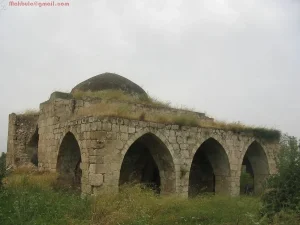
- al-Ghabisiyya was mostly destroyed with the exception of its mosque.
- Ethnic cleansing
- In February 1949, al-Ghabisiyya inhabitants, and some from the nearby villages of al-Shayskh Dawoud & al-Shaykh Danunn, were completely ethnically cleansed to Lebanon.
- Settlements built on the built-up area of Al-Ghabisiyya after 1948
- Netiv ha-Shayyara, established in 1950 by Jewish immigrants from Iraq on village land, 1.25 km west of the village site
- Refugees' migration routes
- Many of Ghabisiyya inhabitants were expelled to the upper Galilee until the whole region fell at the end of October 1948, soon after that they were on the move again to Lebanon.
Hover a dot to read the village name, or click to open its card.
Borders of the depopulated village of Al-Ghabisiyya
al-Ghabisiyya: A Depopulated Palestinian Village in the Acre District
al-Ghabisiyya was a Palestinian village in the Acre District, located at the foothills of the western Galilee mountains on the eastern edge of the Acre Plain, approximately 11.5 kilometres northeast of the city of Acre, at an average elevation of about 75 metres above sea level. Units of the Carmeli Brigade occupied the village on 20–21 May 1948 during the final stage of Operation Ben-Ami. Its inhabitants were displaced in several stages during and after the Nakba.
- Subdistrict
- Acre
- Distance from district center
- 11.5 km northeast of Acre
- Average Elevation
- 75 m above sea level
- Population in 1931
- 470 – al-Ghabisiyya alone; together with Shaykh Dannun and Shaykh Dawud the population was 847
- Number of Houses in 1931
- 206 – for a joint statistical unit comprising al-Ghabisiyya, Shaykh Dannun and Shaykh Dawud, not the village alone
- Population in 1944/1945
- 690 – al-Ghabisiyya alone; together with Shaykh Dannun and Shaykh Dawud the population was 1,240
- Estimated Population in 1948
- About 800 – a later demographic estimate, not an official census
- Total Land Area in 1945
- 11,786 dunams – for a joint statistical unit comprising al-Ghabisiyya, Shaykh Dannun and Shaykh Dawud, not the village alone
- Attack and Depopulation
- Units of the Carmeli Brigade attacked the village on 20–21 May 1948 from the north and southeast, shelling it from a house they had seized at its southern edge and killing and wounding many villagers as they fled; it was the last village taken in Operation Ben-Ami. Some of its inhabitants were expelled in the following days or weeks, and a second expulsion of inhabitants who had remained was carried out by the Israeli Military Government in February 1949.
- Final Israeli Control
- 20–21 May 1948, at the end of Operation Ben-Ami
- Military Operation
- Operation Ben-Ami
- Military Unit
- Units of the Carmeli Brigade
- Cause of Depopulation
- Direct military assault and shelling by Israeli occupation forces, followed by the expulsion of those who remained; some inhabitants had been evacuated before the assault because of the fall of Acre
- Settlements Documented on Village Lands
- Netiv ha-Shayyara, established in 1950 by Jewish immigrants from Iraq on village land, 1.25 km west of the village site
Location
al-Ghabisiyya stood on a rocky hill rising from the Acre Plain at the foothills of the western Galilee mountains, immediately south of the highway linking Tarshiha and Nahariyya with Acre.
The village had an average elevation of approximately 75 metres above sea level and lay about 11.5 kilometres northeast of Acre.
Wadi al-Mafshukh ran through the area north of the village.
al-Ghabisiyya, Shaykh Dawud, and Shaykh Dannun were located very close to one another. Shaykh Dawud and Shaykh Dannun overlapped in some places, while al-Ghabisiyya stood approximately 500 metres away from them.
Architecture and Social Life
In the late nineteenth century, al-Ghabisiyya was described as a stone-built village standing on the crest of a hill. It had approximately 150 inhabitants at the time and was surrounded by olive, fig, and pomegranate trees and gardens.
During the Mandate period, village houses were constructed of reinforced concrete or, in some cases, stone held together with mud or cement mortar.
The populations of al-Ghabisiyya, Shaykh Dawud, and Shaykh Dannun were Muslim.
Education
al-Ghabisiyya had a school established during the Ottoman period in 1886, which continued to serve as one of the village's educational institutions in later years.
Population
Population figures for al-Ghabisiyya must distinguish between the village itself and the combined statistical unit that also included Shaykh Dannun and Shaykh Dawud.
Palestine Remembered lists 427 inhabitants for al-Ghabisiyya in the 1922 census.
In 1931, al-Ghabisiyya itself had 470 inhabitants, while the combined population of al-Ghabisiyya, Shaykh Dannun, and Shaykh Dawud was 847.
According to the 1944/1945 statistics, al-Ghabisiyya alone had 690 Arab inhabitants, while the combined population of the three villages was 1,240.
The figure of 1,240 should therefore not be presented as the population of al-Ghabisiyya alone.
The estimates of 1,438 inhabitants for 1948 and 8,833 refugees and descendants in 1998 published by Palestine Remembered are based on the combined 1,240 figure and are therefore not used here as independent estimates for al-Ghabisiyya alone.
Population Figures Associated with al-Ghabisiyya
- Late nineteenth centuryAbout 150Historical estimate for al-Ghabisiyya
- 1922427al-Ghabisiyya
- 1931470al-Ghabisiyya alone
- 1931847al-Ghabisiyya, Shaykh Dannun, and Shaykh Dawud combined
- 1944/1945690al-Ghabisiyya alone
- 1944/19451,240al-Ghabisiyya, Shaykh Dannun, and Shaykh Dawud combined
Number of Houses
Palestine Remembered lists 125 houses for al-Ghabisiyya in 1931, while PalQuest gives 206 houses for the combined statistical unit of al-Ghabisiyya, Shaykh Dannun, and Shaykh Dawud.
The figure of approximately 382 houses for 1948 found in some later tables is tied to the combined population estimate and is therefore not used here as the number of houses in al-Ghabisiyya alone.
Lands of al-Ghabisiyya, Shaykh Dannun, and Shaykh Dawud
The 1944/1945 land statistics combined al-Ghabisiyya, Shaykh Dannun, and Shaykh Dawud in a single statistical unit. The following figures should therefore not be interpreted as the land area of al-Ghabisiyya alone.
The combined lands of the three villages covered 11,786 dunams, including 11,771 dunams of Arab-owned land and 15 dunams of public land. No Jewish-owned land was recorded in the statistical unit.
Land Ownership of al-Ghabisiyya, Shaykh Dannun, and Shaykh Dawud in 1944/1945
- Arab ownership11,771 dunums100%
- Jewish ownership0 dunums0%
- Public land15 dunums<1%
Agriculture and Economic Life
The economy of al-Ghabisiyya depended primarily on agriculture and livestock raising, with cereals and vegetables among the principal crops.
The inhabitants also cultivated olives, which were processed in two animal-powered presses, one in al-Ghabisiyya and another in Shaykh Dawud.
According to the 1944/1945 statistics, 6,633 dunams of the combined lands of the three villages were devoted to cereals, while 1,371 dunams were irrigated or used for plantations.
Approximately 300 dunams in al-Ghabisiyya itself were planted with olive trees. This figure formed part of the cultivated land and should not be added separately to the overall land-use totals.
Land Use of al-Ghabisiyya, Shaykh Dannun, and Shaykh Dawud in 1944/1945
- Arab
- Public
- Cereals6,633 dunums
- Irrigated and plantation land1,371 dunums
- Built-up area58 dunums
- Uncultivable land3,724 dunums
Archaeology
The al-Ghabisiyya area contained numerous caves that had been used as burial places.
Walid Khalidi, drawing on earlier studies, suggests that the large number of burial caves indicates that the site was probably inhabited during the Canaanite period.
This is best treated as a probable archaeological interpretation rather than conclusive proof of a specifically identified large Canaanite city at the site.
The Nakba and Operation Ben-Ami
Operation Ben-Ami
Operation Ben-Ami began on 13 May 1948 and continued until 21 May. It was carried out by the Carmeli Brigade with the objective of taking control of the Palestinian villages north of Acre up to the Lebanese border.
al-Ghabisiyya was the last village captured during the operation.
The Assault on al-Ghabisiyya
Units of the Carmeli Brigade attacked al-Ghabisiyya on 20–21 May 1948.
According to testimonies from villagers collected by Palestinian historian Nafez Nazzal, the attack came from two directions, the north and southeast.
The attacking force seized a house at the southern edge of the village and used it as a position from which to shell al-Ghabisiyya, causing deaths and injuries among villagers attempting to flee.
Some inhabitants had already left before the final assault following the fall of the city of Acre.
The local defenders, numbering approximately twenty men according to villagers' testimony and possessing poor weapons, decided not to engage the attacking force in an open confrontation.
PalQuest, through Walid Khalidi, who in turn cites Benny Morris, states that the village formally surrendered and that some inhabitants were expelled during the following days or weeks. This detail is included only as transmitted through the Palestinian source.
The date of 1 May 1948 given in the summary table on Palestine Remembered does not correspond with the detailed chronology of Operation Ben-Ami. This article therefore adopts 20–21 May as the date of the assault and occupation.
Displacement After the Occupation
The depopulation of al-Ghabisiyya was not a single event confined to the day of its occupation.
Most displaced villagers initially remained in other villages of Galilee after May 1948. Many were subsequently displaced to Lebanon after Upper Galilee fell at the end of October.
PalQuest, through Walid Khalidi, states that some inhabitants remained in al-Ghabisiyya until February 1949, when the Military Government carried out another expulsion.
A study published by the Institute for Palestine Studies also documents that a number of al-Ghabisiyya residents returned to the village after the fighting ended but were again forced out in late January 1950 and moved to al-Mazra'a and Shaykh Dannun.
These accounts demonstrate that return and expulsion occurred in several stages after the original occupation, making it inaccurate to reduce the village's depopulation to a single date.
Occupation and Depopulation Chronology
- 13–14 May 1948
Beginning of the military operation
The Haganah launched Operation Ben-Ami, carried out by the Carmeli Brigade, to capture all the coastal villages from Acre northwards to the Lebanese border; it was its last major offensive before the end of the British Mandate.
- 20–21 May 1948
Ground assault and shelling of the village
Units of the Carmeli Brigade attacked the village from the north and southeast, according to villagers interviewed by Palestinian researcher Nafez Nazzal, seized a house in its southernmost corner and shelled the village from it, killing and wounding many villagers as they fled. The village militia, about twenty poorly armed men, decided not to confront the attackers.
- 20–21 May 1948
Final occupation
Al-Ghabisiyya was taken as the last village to fall in Operation Ben-Ami; according to Morris as cited by PalQuest, the village surrendered formally.
- After 21 May 1948
Depopulation of the village
According to Morris as cited by PalQuest, some of the inhabitants were expelled "sometime during the following days or weeks", and most of those driven out remained in other villages in Galilee.
- Late October 1948
Displacement of the inhabitants to Lebanon
Most of those driven out of the village remained in other villages in Galilee until the whole region fell at the end of October 1948; after that, they were displaced to Lebanon.
- February 1949
Expulsion of the remaining inhabitants
According to Israeli sources cited by Morris, as reported by Khalidi, some inhabitants remained in the village until February 1949, when a second expulsion was carried out by the Military Government on grounds of "security, law and order"; it is not clear where the expelled villagers were taken.
- 1950
Settlement on village lands
Jewish immigrants from Iraq established the settlement of Netiv ha-Shayyara on village land, 1.25 km west of the village site.
Attempts to Return
Former residents of al-Ghabisiyya who remained inside Palestine continued attempting to return to their village after the Nakba.
On 30 November 1951, a judicial ruling removed the legal obstacle to their return, but Israeli authorities prevented the Palestinian community from permanently re-establishing itself in al-Ghabisiyya and used military orders to close the area.
The Institute for Palestine Studies documents that the village houses were subsequently demolished, leaving the mosque as the principal surviving building. The case of al-Ghabisiyya consequently became one of the notable struggles of internally displaced Palestinians seeking to return to their original villages.
Israeli Settlement on the Lands of al-Ghabisiyya
Netiv ha-Shayyara
In 1950, Jewish immigrants from Iraq established Netiv ha-Shayyara on the lands of al-Ghabisiyya, approximately 1.25 kilometres west of the village site.
- 1950Netiv ha-Shayyara
Established on al-Ghabisiyya's lands, approximately 1.25 kilometres west of the village site
The Site of al-Ghabisiyya After the Nakba
According to the field documentation relied upon by Walid Khalidi, the mosque was the principal surviving landmark of al-Ghabisiyya.
It is a domed stone structure with arched doors and windows and decorative arches in its interior. At the time of documentation, it stood abandoned and wild vegetation covered parts of its roof.
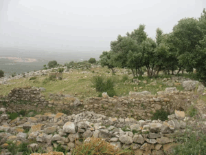
The rubble of village houses, agricultural terraces, and the cemetery remained visible among a dense cypress forest planted over the village site and part of its lands. Cactus plants also grew in the area.
Netiv ha-Shayyara used the neighbouring non-forested lands for agriculture.
This description reflects the condition of the site during the period of field documentation relied upon by Walid Khalidi and should not necessarily be interpreted as a comprehensive survey updated to 2026.
Sources
- PalQuest – Interactive Encyclopedia of the Palestine Question: al-Ghabisiyya.
- PalQuest: al-Ghabisiyya.
- PalQuest: Operation Ben-Ami.
- Palestine Remembered: al-Ghabisiyya, Acre District.
- Walid Khalidi, All That Remains: al-Ghabisiyya, as reproduced by Palestine Remembered.
- Institute for Palestine Studies: study discussing the al-Ghabisiyya return case.
- Walid Khalidi, All That Remains, entry on al-Ghabisiyya.
- Nafez Nazzal, The Palestinian Exodus from Galilee, 1948, Institute for Palestine Studies.
- Government of Palestine, censuses of 1922 and 1931.
- Government of Palestine, Department of Statistics, Village Statistics, 1945.
Photo gallery


Photos from the village's people
Photos sent in by visitors and published after review.
Add a photo of this village
Log in to add photos of this village.
Other villages from Akka (Acre)

More from the archive


 Download Our Palestine App
The whole archive in the palm of your hand: depopulated villages, the Nakba, the massacres and Al-Aqsa — free, with no ads to erase the story.
Download Our Palestine App
The whole archive in the palm of your hand: depopulated villages, the Nakba, the massacres and Al-Aqsa — free, with no ads to erase the story.



Comments
No comments yet — be the first to write one.
Add your comment
Name and email are optional. Comments appear after review.