
The depopulated village of Kafr 'Ana / District of Jaffa
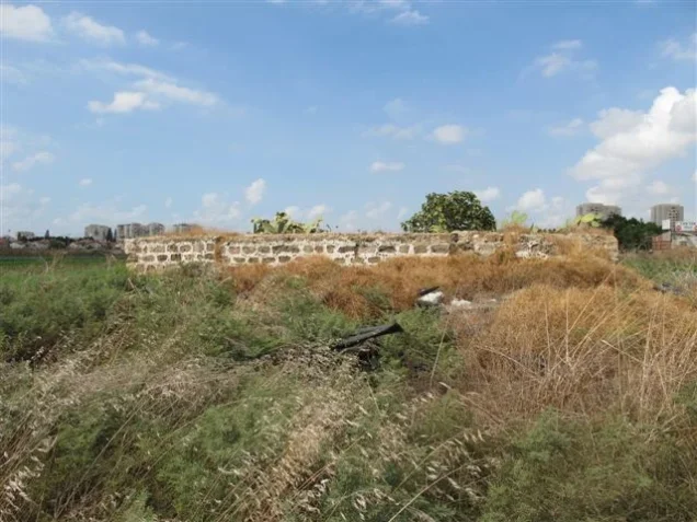
Kafr 'Ana
About the depopulated village of Kafr 'Ana
- District
- Jaffa
- Date Kafr 'Ana was occupied
- 29 April 1948
- Population in 1948
- 3,248
- Military operation
- Operation Bi'ur Hametz
- Brigade that carried it out
- Probably the Haganah's Alexandroni Brigade; Khalidi considers it likely that the village fell together with the neighbouring village of Saqiya, which this brigade occupied
- Distance from the governorate centre
- 11 km east of Jaffa
- Elevation above sea level
- 35 m
- Cause of displacement
- Direct military assault by Zionist forces (the Haganah) in the course of Operation Hametz
- Extent of destruction
- On 13th of September 1948, Kafr 'Ana was completely defaced with the exception of its mosque, see Pictures section for details.
- Ethnic cleansing
- Kafr 'Ana inhabitants were completely ethnically cleansed.
- Settlements built on the built-up area of Kafr 'Ana after 1948
- Yagel, established in 1950 on village lands south of the village site; and Newe Efrayim, established in 1953 on or very near the village site
Hover a dot to read the village name, or click to open its card.
Borders of the depopulated village of Kafr 'Ana
Kafr 'Ana: A Depopulated Palestinian Village in the Jaffa District
Kafr 'Ana was a depopulated Palestinian village in the Jaffa District, located approximately 11 kilometers east of the city of Jaffa on flat terrain in the central coastal plain. Its average elevation was about 35 meters above sea level.
- Subdistrict
- Jaffa
- Distance from district center
- 11 km east of Jaffa
- Average Elevation
- 35 m above sea level
- Population in 1931
- 1,824
- Number of Houses in 1931
- 449
- Population in 1944/1945
- 2,800 – Arab population; the same statistical unit also recorded 220 Jews (total 3,020)
- Estimated Population in 1948
- About 3,248 – a later demographic estimate, not an official census
- Total Land Area in 1945
- 17,353 dunams
- Attack and Depopulation
- The village was occupied in the course of the Haganah's Operation Hametz, which was designed to isolate Jaffa, and it was probably seized on 29 April 1948 together with the neighbouring village of Saqiya, which the Alexandroni Brigade occupied, according to Khalidi. On 13 September 1948 it was placed on a list of fourteen villages that Ben-Gurion asked permission to destroy, and those villages were levelled soon afterwards, according to Morris as cited by Khalidi.
- Final Israeli Control
- Probably 29 April 1948, the day the neighbouring village of Saqiya fell, according to Khalidi; the sources give no confirmed date for the fall of the village itself
- Military Operation
- Operation Hametz
- Military Unit
- Probably the Haganah's Alexandroni Brigade; Khalidi considers it likely that the village fell together with the neighbouring village of Saqiya, which this brigade occupied
- Cause of Depopulation
- Direct military assault by Zionist forces (the Haganah) in the course of Operation Hametz
- Settlements Documented on Village Lands
- Yagel, established in 1950 on village lands south of the village site; and Newe Efrayim, established in 1953 on or very near the village site
The village was connected by roads to Jaffa, Lydda, and Ramla, while a secondary railway line connected Kafr 'Ana with the main railway running between Lydda and Tulkarm. During the Nakba and the occupation of Palestine in 1948, Kafr 'Ana was occupied by Haganah forces in the course of Operation Hametz. Its Palestinian inhabitants were displaced, and most of the village was subsequently destroyed.
Location of Kafr 'Ana
- Kafr 'Ana was located approximately 11 kilometers east of Jaffa.
- Its average elevation was about 35 meters above sea level.
- The village stood on flat terrain in the central coastal plain.
- Two roads connected it with the road network leading to Jaffa, Lydda, and Ramla.
- A secondary railway line connected Kafr 'Ana with the main line running between Lydda and Tulkarm.
- Nearby Palestinian villages included Saqiya, al-'Abbasiyya, al-Safiriyya, Rantiya, and Bayt Dajan.
Kafr 'Ana Through History
Walid Khalidi suggests that Kafr 'Ana may have been built on the site of the Canaanite settlement of Ono, which was mentioned in the Karnak list associated with the Egyptian pharaoh Thutmose III in the fifteenth century BCE, rather than the fifth century BCE as stated in the earlier draft.
The source also indicates that it appears to have been a fortified town during the Iron Age and that it was known as Onous during the Byzantine period.
In 1596, according to the PalQuest entry on Kafr 'Ana, the village had a population of 116. Its inhabitants paid taxes on agricultural products including wheat, barley, olives, and fruit, as well as goats, beehives, and vineyards.
The Built Environment of Kafr 'Ana
In the late nineteenth century, Kafr 'Ana was described as a village built of adobe bricks and surrounded by palm trees. Its later houses were constructed along the two principal roads, and the village expanded westward and northward toward the Jaffa–Lydda road.
The built-up area covered approximately 90 dunums in the 1944/1945 statistics.
Population of Kafr 'Ana
Kafr 'Ana had 1,374 inhabitants in the official 1922 census, all of them Muslims. By the 1931 census, the population had increased to 1,824 Muslims living in 449 houses.
The Government of Palestine's 1944/1945 statistics recorded a total population of 3,020 within the Kafr 'Ana statistical unit, consisting of 2,800 Arabs and 220 Jews.
The figures of 3,248 inhabitants for 1948 and 19,946 refugees for 1998 published by Palestine Remembered are later estimates and are not official Government of Palestine censuses.
Population of Kafr 'Ana
- 1596116Historical estimate based on Ottoman-era records as cited by Walid Khalidi
- 19th century121Figure published by Palestine Remembered; not an official census with a clearly specified year
- 19221,374Official census under the British Mandate
- 19311,824Official census; all inhabitants were Muslims
- 1944/19453,020Government of Palestine statistics: 2,800 Arabs and 220 Jews
- 19483,248Estimate published by Palestine Remembered
- 199819,946Estimated refugee population published by Palestine Remembered
Land Ownership in Kafr 'Ana
The total land area recorded for Kafr 'Ana in the 1944/1945 statistics was 17,353 dunums.
The Arabic Palestine Remembered table uses the categories “Palestinian,” “Transferred to Zionists,” and “Masha'.” These terms are preserved here to reflect the wording of that source. The underlying Government of Palestine statistics, as reproduced by PalQuest, classify the corresponding categories as “Arab,” “Jewish,” and “Public.”
Land Ownership in Kafr 'Ana, 1944/1945, Using the Terminology of Palestine Remembered
- Palestinian14,358 dunums83%
- Transferred to Zionists2,334 dunums13%
- Masha' / Communal661 dunums4%
Land Use in Kafr 'Ana in 1944/1945
The land-use statistics demonstrate the importance of agriculture in Kafr 'Ana, particularly citrus, bananas, cereals, and orchards. In this table, the term “Jewish” is retained because that is the classification used by the source for land-use statistics.
Land Use in Kafr 'Ana, 1944/1945
- Palestinian
- Jewish
- Public
- Citrus and Bananas2,377 dunums
- Irrigated Land and Plantations597 dunums
- Cereals13,194 dunums
- Built-up Area90 dunums
- Non-Cultivable Land1,095 dunums
Economic Life in Kafr 'Ana
The inhabitants of Kafr 'Ana depended heavily on agriculture and also raised poultry and kept bees. In 1944/1945, 2,214 dunums of Palestinian land were devoted to citrus and bananas, 11,022 dunums to cereals, and 597 dunums were irrigated or used for orchards.
The extensive cultivation of citrus and cereals reflected the village's location on the central coastal plain and its agricultural links with the areas surrounding Jaffa and Lydda.
Education in Kafr 'Ana
Kafr 'Ana had two schools, one for boys and one for girls. The boys' school was founded in 1920 and owned 22 dunums of land. It had 270 pupils in 1944.
The girls' school was established in 1945. The English PalQuest entry and the structured education data on Palestine Remembered record 57 girls enrolled that year, while the Arabic reproduction of the All That Remains narrative on Palestine Remembered gives a figure of 75. Because the source itself contains this discrepancy, the figure of 57 is used here while the alternative figure is explicitly noted.
Archaeological Remains in Kafr 'Ana
Kafr 'Ana itself was an archaeological site, and another archaeological site, Khirbat Kafrajun, lay immediately to the east.
Walid Khalidi tentatively associates the village site with the Canaanite Ono mentioned in the list of Thutmose III. The settlement was later known as Onous during the Byzantine period.
The Occupation of Kafr 'Ana and the Displacement of Its Inhabitants During the Nakba
Kafr 'Ana was among the Palestinian villages east of Jaffa targeted by the Haganah during Operation Hametz in late April 1948. The immediate objective of the operation was to seize the villages around the roads and railway linking Jaffa with its Palestinian hinterland, thereby isolating the city and preparing the way for its occupation.
At the operational level, Operation Hametz involved three Haganah brigades: Alexandroni, Kiryati, and Giv'ati. PalQuest states that the main assault was launched on 29 April under the command of Dan Epstein, commander of the Alexandroni Brigade, whose units attacked villages east of Jaffa.
Regarding Kafr 'Ana itself, Walid Khalidi considers it probable that the village was occupied on the same day as neighboring Saqiya, on 29 April 1948, by the Alexandroni Brigade.
This date differs from the Palestine Remembered data table, which lists 25 April 1948 as the date of occupation and identifies the Alexandroni Brigade as the attacking unit. Because the sources differ, 29 April is presented here as the probable date in Khalidi's account, while 25 April is retained as an alternative date given by Palestine Remembered.
The attack resulted in the displacement of the village's Palestinian inhabitants during the Nakba. Approximately four months later, on 13 September 1948, Kafr 'Ana was among fourteen villages placed on a list for demolition. Walid Khalidi, citing Israeli historian Benny Morris, notes that Morris's sources do not make clear whether formal authorization for the demolitions was granted, but state that the villages were levelled shortly afterward. This information is included because it is cited by the Palestinian source PalQuest/Khalidi and is not based on independent use of an Israeli source.
Occupation and Depopulation Chronology
- 29 April 1948
Beginning of the military operation
Four days after the Irgun's frontal attack on Jaffa, the Haganah launched Operation Hametz with units from the Alexandroni, Kiryati and Giv'ati Brigades, aiming to seize the villages on both sides of the railway linking Jaffa to its Arab hinterland and to isolate the city. Kafr 'Ana was one of the villages north of the railway targeted by the operation.
- Probably 29 April 1948
Final occupation
Khalidi considers it probable that the village fell on the same day as the neighbouring village of Saqiya, which the Alexandroni Brigade occupied on 29 April, as one of the cluster of villages east of Jaffa occupied in the course of Operation Hametz.
- 13 September 1948 (request for permission to destroy), and shortly afterwards
Destruction of the village
Israeli Prime Minister David Ben-Gurion placed Kafr 'Ana on a list of fourteen villages he asked his cabinet for formal permission to destroy. Morris, as cited by Khalidi, does not make clear whether permission was granted, but notes that the villages were levelled soon afterwards.
- Late September 1948
Designation of the village as a site for settling Jewish immigrants
Later that month, Kafr 'Ana was mentioned as a site for the settlement of new Jewish immigrants, according to Khalidi.
- 1950
Settlement on village lands
The settlement of Yagel was established on village lands, south of the village site.
- 1953
Settlement on village lands
The settlement of Newe Efrayim was established on or very near the village site.
Settlements Established on the Lands of Kafr 'Ana
Walid Khalidi identifies two settlements established on the lands of Kafr 'Ana after the Nakba:
- Yagel: established in 1950 on village land, south of the village site.
- Newe Efrayim: established in 1953 on or very near the village site.
The Site of Kafr 'Ana After the Nakba
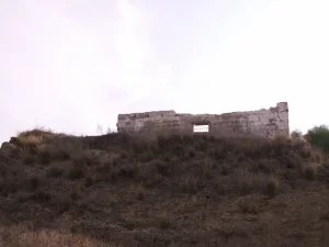
According to Walid Khalidi's field description, part of the village site had become vacant land, while olive trees continued to grow in other areas alongside cypress and eucalyptus trees planted after the Nakba. No traces of the old houses were discernible at the time of that survey, and apartment buildings and a small park had been constructed on surrounding land.
Palestine Remembered describes the village as having been extensively destroyed and documents the mosque of Kafr 'Ana as one of the principal surviving landmarks. The available site descriptions were recorded at different times and should therefore not be treated as a comprehensive field survey updated to the present day.
Sources
- PalQuestPalQuest – Interactive Encyclopedia of the Palestine Question: Kafr 'Ana
- PalQuestPalQuest – Interactive Encyclopedia of the Palestine Question: Operation Hametz
- Institute for Palestine StudiesInstitute for Palestine Studies: Walid Khalidi, All That Remains
- Palestine RememberedPalestine Remembered: Kafr 'Ana – Jaffa District
- maktabatsabil.comVillage Statistics of 1945: Population and Land Ownership in the Jaffa District, based on Government of Palestine statistics
- Palestine RememberedGovernment of Palestine: Census of Palestine, 1931
Photo gallery


Photos from the village's people
Photos sent in by visitors and published after review.
Add a photo of this village
Log in to add photos of this village.
Other villages from Jaffa
More from the archive
 Download Our Palestine App
The whole archive in the palm of your hand: depopulated villages, the Nakba, the massacres and Al-Aqsa — free, with no ads to erase the story.
Download Our Palestine App
The whole archive in the palm of your hand: depopulated villages, the Nakba, the massacres and Al-Aqsa — free, with no ads to erase the story.



Comments
No comments yet — be the first to write one.
Add your comment
Name and email are optional. Comments appear after review.