
The depopulated village of Yazur / District of Jaffa
About the depopulated village of Yazur
- District
- Jaffa
- Date Yazur was occupied
- 01 May 1948
- Population in 1948
- 4,675
- Military operation
- Operation Bi'ur Hametz
- Who defended the village
- Local militia & Arab Liberation Army
- Distance from the governorate centre
- 6 (km) East of Jaffa
- Elevation above sea level
- 25 m
- Cause of displacement
- Military assault by Zionist troops
- Extent of destruction
- Yazur was mostly destroyed with the exception of its shrines.
- Ethnic cleansing
- Yazur inhabitants were completely ethnically cleansed.
- Settlements built on the land of Yazur before 1948
- Miqwe Yisrael
- Settlements built on the built-up area of Yazur after 1948
- Azor. Parts of Holon and its industrial zone later expanded over village lands.
Hover a dot to read the village name, or click to open its card.
Borders of the depopulated village of Yazur
Yazur: A Depopulated Palestinian Village in the Jaffa Subdistrict
Yazur was one of the largest and most prosperous Palestinian villages in the Jaffa subdistrict, particularly known for its citrus cultivation. The village was occupied and its inhabitants were displaced during the Nakba, in the course of Operation Hametz, which targeted the Palestinian villages surrounding Jaffa and sought to isolate the city from its hinterland.
- Subdistrict
- Jaffa
- Distance from district center
- 6 km East of Jaffa
- Average Elevation
- 25 meters above sea level
- Population in 1931
- 2,337 inhabitants - Official Government of Palestine census
- Number of Houses in 1931
- 419 houses - Official Government of Palestine census figure
- Population in 1944/1945
- 4,030 inhabitants - Official Government of Palestine estimate
- Estimated Population in 1948
- 4,675 inhabitants - a later demographic estimate, not an official census
- Total Land Area in 1945
- 11,807 dunams
- Attack and Depopulation
- Operation Hametz Yazur was occupied during Operation Hametz, an offensive conducted by the Haganah to occupy the villages surrounding Jaffa and sever the city’s connections with its Palestinian hinterland. The operation was intended to complete Jaffa’s isolation during the occupation of Palestine in 1948.
- Final Israeli Control
- 30 April-1 May 1948
- Military Operation
- Operation Hametz
- Military Unit
- The Givati Brigade within the Haganah forces of Operation Hametz
- Cause of Depopulation
- Military assault by Zionist troops
- Settlements Documented on Village Lands
- Azor. Parts of Holon and its industrial zone later expanded over village lands.
Location and Area
Yazur was situated on level ground in the central coastal plain, approximately 6 kilometers east of Jaffa. It stood about 25 meters above sea level.
The village was connected to Jaffa and Ramla by the main road linking the two cities. It was also connected to Jaffa and Lydda by railway. Its location near the transportation routes leading to Jaffa gave Yazur considerable economic and strategic importance.
According to the 1944/1945 statistics, Yazur’s lands covered a total of 11,807 dunums. Its built-up area covered only 87 dunums; therefore, the latter figure does not represent the village’s total land area.
Yazur Through History
Archaeological evidence indicates that the site of Yazur was inhabited during the Chalcolithic period, around the fifth millennium BCE. Two caves at the site contained burials dating from that period.
Yazur was mentioned as “Azuru” in the annals of the Assyrian king Sennacherib. Its name also appeared as “Azor” in the Septuagint. During the twelfth and thirteenth centuries, Muslim and Crusader forces contested control of the village, which changed hands more than once.
The Arab geographer Yaqut al-Hamawi described Yazur as a small town that was the birthplace of several prominent figures during the Fatimid period. The most notable was al-Hasan ibn Ali al-Yazuri, who became a minister in the Fatimid state during the eleventh century.
Ottoman tax records from 1596 listed Yazur as part of the nahiya of Ramla in the liwa of Gaza. Its population was estimated at approximately 275. The villagers paid taxes on wheat, barley, fruit and sesame, in addition to goats and beehives.
Population and Built Environment
In the late nineteenth century, Yazur was described as a village built mainly of adobe brick and surrounded by gardens and wells. It also contained a domed shrine.
Modern Yazur was divided into four quarters, each associated with one of the four clans residing in the village. Houses were constructed from stone or adobe brick mixed with straw. Many were arranged in residential compounds known as ahwash. The houses of each hawsh opened onto a shared courtyard with a single entrance, often marked by an arched gateway.
Population of Yazur
- 1596275Estimate based on Ottoman tax records
- 19221,284Official Government of Palestine census
- 19312,337Official Government of Palestine census
- 1944/19454,030Official Government of Palestine estimate
- 19484,675Population estimate, not an official census
- 199828,708Estimate of refugees descended from the village’s inhabitants, not the population of the site
In 1944/1945, Yazur had 4,010 Muslim and 20 Christian inhabitants, giving a total population of 4,030.
Number of Houses in Yazur
- 1931419Official Government of Palestine census figure
- 1948838Published estimate, not an official census figure
Land Ownership
According to the Government of Palestine’s 1944/1945 statistics, Yazur’s lands covered 11,807 dunums. Recorded ownership was distributed as follows:
Land Ownership in Yazur, 1944/1945
- Palestinian Arab ownership9,742 dunums83%
- Registered Jewish ownership1,428 dunums12%
- Public land637 dunums5%
Economy and Land Use
Agriculture formed the backbone of Yazur’s economy, with citrus fruit serving as its principal crop. The villagers also cultivated cereals and irrigated orchards. Farming depended on both rainfall and water drawn from artesian wells.
During the Second World War, villagers began raising Holstein cattle for milk production. Palestinian local sources state that approximately 140 artesian wells were operating shortly before the Nakba. PalQuest confirms the presence of numerous artesian wells used for irrigation by 1947 but does not provide the same exact total.
Land Use in Yazur, 1944/1945
- Arab Land
- Jewish Land
- Public Land
- Citrus and bananas6,723 dunums
- Plantations and irrigable land1,769 dunums
- Cereals2,325 dunums
- Built-up area87 dunums
- Non-cultivable land903 dunums
Palestinian geographical sources state that approximately 30 dunums were planted with olive trees. This area should be treated as part of the land classified as plantations and should not be added again to the totals in the table.
The original text also stated that dairy production generated approximately 25,000 Palestinian pounds annually and that the village’s total annual income reached 140,000 Palestinian pounds. These were presented as estimates without an identified statistical methodology and therefore cannot be treated as official figures.
Education
Yazur had two elementary schools: a boys’ school established in 1920 and a girls’ school opened in 1933.
The boys’ school occupied approximately 27 dunums, most of which were used to teach agricultural work. It also had its own artesian well. In 1947, approximately 430 boys and 160 girls were enrolled in the village’s schools.
The figure of 160 girls provided by PalQuest differs from the 106 pupils stated in the original text for the 1947/1948 school year. The PalQuest figure has been retained because it is based on the research published in All That Remains, while the disagreement has been explicitly noted.
Archaeological and Religious Sites
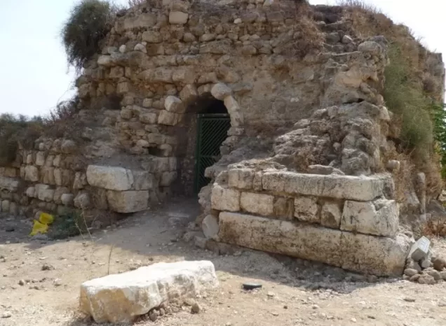
Yazur contained the remains of a Crusader castle known as Casel des Plains, or the Castle of the Plains. The sources attribute its construction to Richard the Lionheart in 1191.
The village also contained the remains of a Crusader church that was later rebuilt and used as Yazur’s mosque. The mosque, market and coffeehouse formed the center of public life in the village.
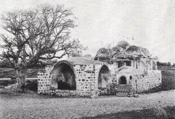
Yazur was known for several shrines, the most prominent of which was the shrine of Imam Ali, a stone structure topped by a cluster of smaller domes surrounding a larger central dome.
Attacks on Yazur Before the Nakba
Yazur was subjected to repeated attacks beginning in December 1947. The Palestinian newspaper Filastin reported that, on 11 December, a vehicle passed through the village and its occupants threw bombs at a coffeehouse and a barbershop, without causing any deaths.
According to Palestinian historian Arif al-Arif, a Zionist force disguised as British soldiers entered the village on 18 December and threw bombs at a coffeehouse beside the main road, killing six villagers.
Raids continued during January and February 1948 and included the demolition of houses and the shelling of the village with mortars and machine guns.
On 20 February 1948, a Zionist force advanced on Yazur from the west and north under mortar cover. According to the account published by Filastin and reproduced by PalQuest, the attackers used tanks and armored vehicles, destroyed an ice factory and two houses, killed one villager and wounded four others.
The Occupation of Yazur and the Displacement of Its Inhabitants
Operation Hametz
Yazur was occupied during Operation Hametz, an offensive conducted by the Haganah to occupy the villages surrounding Jaffa and sever the city’s connections with its Palestinian hinterland. The operation was intended to complete Jaffa’s isolation during the occupation of Palestine in 1948.
The operation targeted Palestinian villages on both sides of the railway connecting Jaffa with the surrounding region. These included Yazur, Bayt Dajan, al-Safiriyya, Salama, al-Khayriyya, Saqiya, Kafr Ana and al-Abbasiyya.
Participating Brigades
The Alexandroni, Kiryati and Giv‘ati brigades participated in Operation Hametz under the command of Dan Epstein, commander of the Alexandroni Brigade.
According to PalQuest’s study of the operation, the Giv‘ati Brigade conducted the offensive south of the railway from its base at Miqwe Yisrael and occupied Yazur on or shortly after 29 April 1948.
Disagreement Over the Occupation Date
Several accounts cited in PalQuest state that Yazur was occupied on 30 April 1948. The same PalQuest entry reports that Israeli historian Benny Morris gives 1 May 1948 as the date of occupation.
The occupation may therefore be dated cautiously to 30 April–1 May 1948. The first date appears in several accounts, while the second is attributed to Morris exclusively as reproduced by PalQuest. Morris is not used here as a direct source.
Attempt to Defend the Area
Records maintained by Arab Liberation Army commander Fawzi al-Qawuqji, as cited by PalQuest, state that a unit equipped with two field guns was sent to Yazur to shell Tel Aviv and relieve the pressure on Jaffa.
The unit withdrew on 28 April to participate in another battle. Yazur was occupied shortly afterward, along with several other villages in the area.
Displacement and the Fate of the Village
The assault and occupation led to the displacement of Yazur’s Palestinian inhabitants during the Nakba. The principal sources consulted do not identify one destination shared by all the displaced villagers; it would therefore be inaccurate to claim that every inhabitant took refuge in a particular location.
The British authorities initially objected to the Haganah’s occupation of Yazur because the village stood on a major road. They threatened to shell Haganah positions unless they were evacuated by 5 May. A temporary arrangement was subsequently reached under which the houses overlooking the road were handed to British forces, while the Haganah retained control of the remainder of the village.
After the end of the British Mandate, Yazur was used as an Israeli military headquarters during Operation Dani in July 1948.
Occupation and Depopulation Chronology
- Not specified precisely
Operation Hametz
Yazur was occupied during Operation Hametz, an offensive conducted by the Haganah to occupy the villages surrounding Jaffa and sever the city’s connections with its Palestinian hinterland. The operation was intended to complete Jaffa’s isolation during the occupation of Palestine in 1948.
- 30 April 1948
Disagreement Over the Occupation Date
Several accounts cited in PalQuest state that Yazur was occupied on 30 April 1948. The same PalQuest entry reports that Israeli historian Benny Morris gives 1 May 1948 as the date of occupation.
- Not specified precisely
Attempt to Defend the Area
Records maintained by Arab Liberation Army commander Fawzi al-Qawuqji, as cited by PalQuest, state that a unit equipped with two field guns was sent to Yazur to shell Tel Aviv and relieve the pressure on Jaffa. The unit withdrew on 28 April to participate in another battle.
Settlements Established on Yazur’s Lands
- Miqwe Yisrael was established in 1870 on land described by the sources as traditionally belonging to Yazur.
- Azor was established in 1948 on the village’s lands and later expanded into the urban and industrial area connected to Tel Aviv.
The suburbs of Holon adjoin the village lands. However, the consulted source does not classify Holon itself as a settlement established on Yazur’s lands, so it has not been included in the list.
The Village Site After the Nakba
According to the field description published in Walid Khalidi’s All That Remains and made available through PalQuest, two of Yazur’s shrines remained standing. One was a stone structure topped by several smaller domes surrounding a larger central dome.
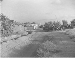
Several village houses and other structures also remained. Some were used for residential or commercial purposes, while others stood vacant. Modern apartment buildings were constructed at the site, where cypress, fig and sycamore trees, as well as cactuses, continued to grow. Parts of the surrounding land were cultivated.
This description records the condition of the site when the field survey associated with Khalidi’s work was conducted. It does not establish that every detail remains unchanged today.
Sources
- Interactive Encyclopedia of the Palestine Question — PalQuest: Yazur
- Interactive Encyclopedia of the Palestine Question — PalQuest: Operation Hametz
- Institute for Palestine Studies: Yazur Village
- Institute for Palestine Studies: All That Remains, edited by Walid Khalidi
- Palestine Remembered: Yazur, Jaffa Subdistrict
- Palestine Remembered: Village Statistics of 1945
Photo gallery




Photos from the village's people
Photos sent in by visitors and published after review.
Add a photo of this village
Log in to add photos of this village.
Other villages from Jaffa
More from the archive
 Download Our Palestine App
The whole archive in the palm of your hand: depopulated villages, the Nakba, the massacres and Al-Aqsa — free, with no ads to erase the story.
Download Our Palestine App
The whole archive in the palm of your hand: depopulated villages, the Nakba, the massacres and Al-Aqsa — free, with no ads to erase the story.



Comments
No comments yet — be the first to write one.
Add your comment
Name and email are optional. Comments appear after review.