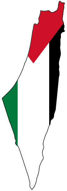
Beersheba Before the Nakba: Capital of the Naqab, From the Saraya to Exile
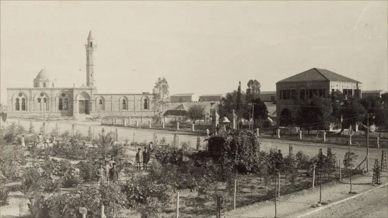
Beersheba, capital of the Naqab, is a Palestinian town on the edge of the desert, rebuilt by the Ottomans in 1900 as the center of the largest district in Palestine, covering about half its area. Before the Nakba it was the market of the Naqab tribes, a town of a Saraya, a railway station and schools for Bedouin children, at the heart of a district of about 95,000 people. It fell on October 21, 1948, and most of the people of the Naqab were driven out to Gaza, Hebron, Jordan and Sinai. [1] [2] [3]
This article tells the story of Beersheba before the Nakba: its Ottoman founding and landmarks, the Bedouin market, the Naqab tribes and their land, tribal justice, its schools and public life, and its struggle in the revolts, then its fall in 1948 and the expulsion of the people and tribes of the Naqab. Find more on our Beersheba page.
Beersheba Before the Nakba at a Glance
| Item | Details |
|---|---|
| Location | The northern Naqab, about 71 km southwest of Jerusalem [2] |
| Rebuilt | 1900, as the center of an Ottoman district bearing its name [2] |
| Town population | More than 1,000 in 1914, and 5,570 in 1945 [3] [5] |
| District population | About 55,000 at the end of the Ottoman era, and about 95,000 at the end of the Mandate [3] |
| District area | About 12,577,000 dunams, nearly half the area of Palestine [3] |
| Fall of the town | October 21, 1948 [1] [2] [3] |
| Who remained in the Naqab | No more than 13,000 out of 95,000 [3] |
From the Ancient Well to the Town of 1900
Beersheba is one of the oldest sites in Palestine, with roots going back to the Canaanite era, and the ruins of its ancient city still stand northeast of the modern town. [1] [2] There are several accounts of its name, from "seven wells" to the story of the well and the seven sheep. [1] [4]
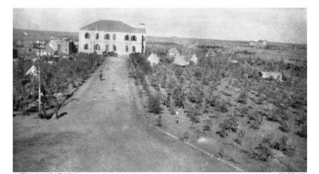
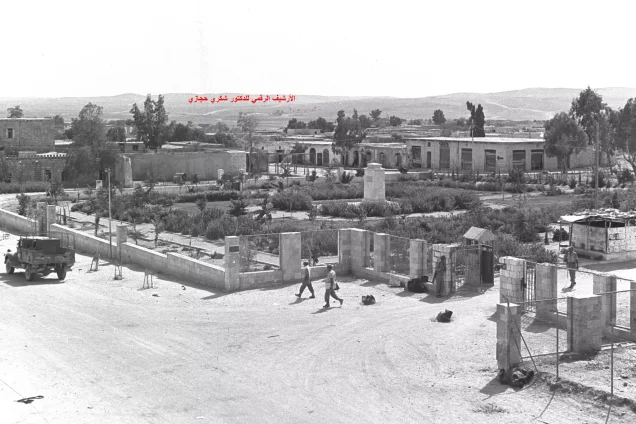
The Ottomans entered the area in 1519 without ruling it directly, then decided, after disputes among the tribes and because the area bordered Egypt, to govern it directly. [2] In 1900 they rebuilt Beersheba and made it the center of a district, setting up a municipal council, a government house and barracks, and drawing up a plan for the town. [2] The Ottoman government bought about 2,000 dunams for the town from the Azazma, led by Hasan al-Multa'a. [3]
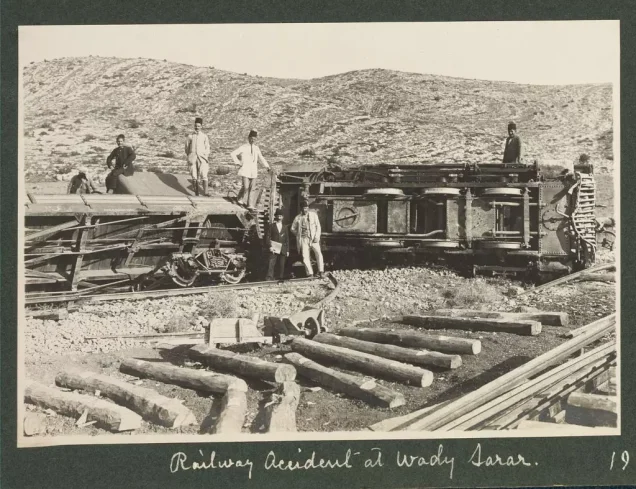
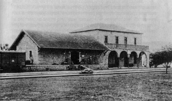
For centuries Beersheba and Gaza were known together as "the land of Gaza," until they were separated in the early 20th century for military reasons. [9] Before that, in 1891, the major tribes signed an agreement setting the boundaries of their lands, which the Ottoman state approved. [10] The new town was laid out in squares, each with a government building, some of which became a hospital, a school, a railway station and a public garden, and the Ottomans built a railway from Jerusalem to Beersheba and on to Awja al-Hafir. [9]
The Ottomans also built a Bedouin market, a mill and shops to draw the people of the area to the town, so that by 1914 it had more than a thousand inhabitants, more than 200 houses and about 50 shops. [3]
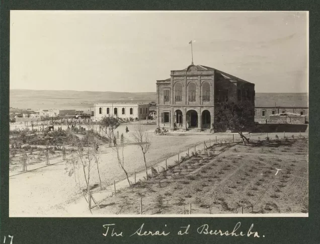
The Saraya, the Station and the Town's Landmarks
- The Saraya: the Ottoman government house and seat of the district governor. [1] [2]
- The railway station: founded by Sultan Abdul Hamid II, linking Beersheba to the railway network. [1] [2]
- The hospital: the town hospital, which appears in photographs from 1917. [1]
- The wells: the town's old wells, including "Abraham's Well." [1]
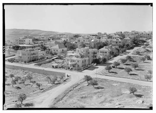
- The old quarters: the town's first houses, built in the Ottoman era. [4]
Most of the town's first inhabitants came from Gaza and Hebron, for trade, government work or teaching, while the tribespeople mostly stayed on their lands around it. [9] Under the Mandate the British recruited young men from the area into the "camel police" and linked nine posts in the Naqab to each other and to Beersheba and Jerusalem by wireless. [9]
The Bedouin Market and the Trade of the Naqab
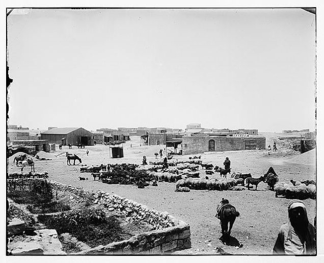
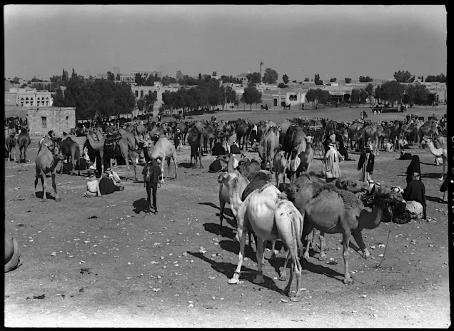
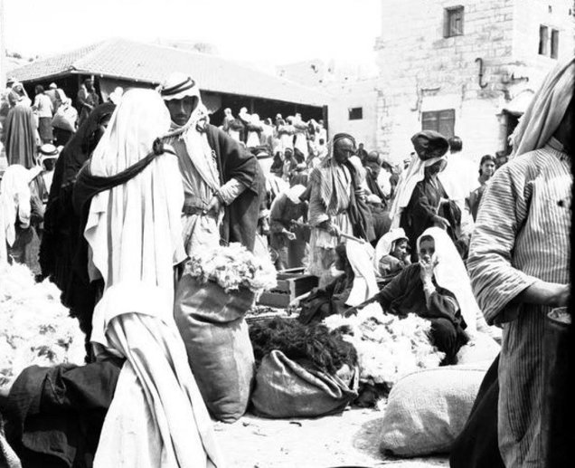
Beersheba was where the merchants of Jerusalem, Hebron, Gaza and al-Majdal met the tribes of the Naqab, and a caravan center on routes carrying goods toward Egypt and the Mediterranean. [2] [4] The "Bedouin market," dating from the Ottoman era, was the heart of its economic life, where camels, sheep and grain were sold and the Bedouin bought what they needed. [1] [2] Tribespeople came to the town from as far as 60 km away to shop, to go to court or to see to their affairs. [9]
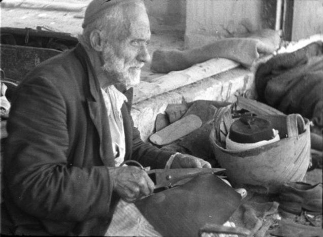
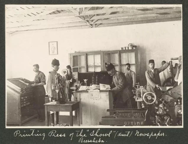
Before the Nakba the town had traditional crafts: grain milling, leather tanning, blacksmithing and weaving. [2] [4] It also had a newspaper printing press, as photographs in the town's gallery show. [1]
The Tribes of the Naqab
Beersheba district and the Naqab were home to 95 Bedouin clans [3], grouped into seven main tribes: the Tarabin, Tiyaha, Azazma, Jabarat, Hanajra, Sa'idiyyin and Ahaywat. [2] [7]
Land was held communally by the tribes, and the British recognized this without forcing its registration; tribal boundaries were drawn on maps such as the Palestine Exploration Fund map of 1870 and Newcombe's map of 1913. [3] In 1914 about 1,400 Bedouin of the Naqab volunteered for the Ottoman campaign against the Suez Canal. [7]
The Bedouin of the Naqab were not fully nomadic: their seasonal movement was short, about 35 km between the south and north of Beersheba, and many of them farmed, so that the cultivated land of the Naqab exceeded four million dunams in 1948. [10] High Commissioner Herbert Samuel issued land laws that penalized cultivating unregistered "dead" (mawat) land, harming the Bedouin; Winston Churchill later assured the sheikhs of Beersheba that Britain recognized their rights and customs. [10]
Tribal justice
Beersheba had a tribal court that met every week and heard all disputes between tribespeople, even murder cases, while land registration remained in the hands of the High Commissioner. [9] Aref al-Aref documented the customs of this justice in his book Justice Among the Bedouin in 1933. [6]
Aref al-Aref, district governor of Beersheba from 1929 to 1939, did more than anyone to document the life of its tribes, in his book The History of Beersheba and Its Tribes (1934) and his work on justice among the Bedouin. [6] [8]
Land, Farming and Wells
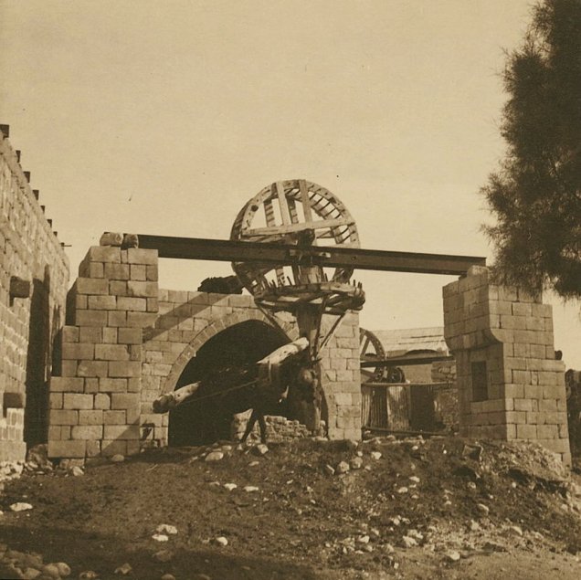
Life in the Naqab rested on rain-fed farming and herding: barley, wheat, corn, lentils and fava beans were grown, and camels and sheep were raised. [1] [2] The town had orchards from the Ottoman era [3], and its wells were the source of water for its people and for the Bedouin caravans.
Schools for the Bedouin
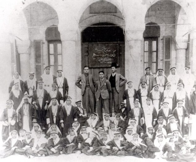
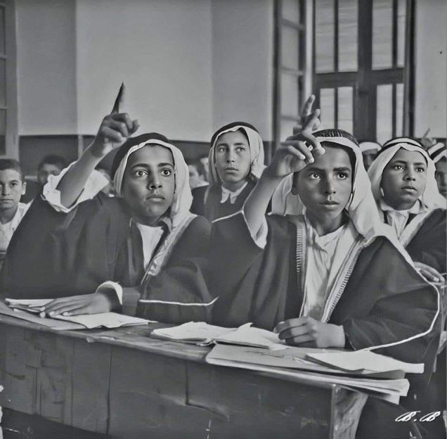
From its founding Beersheba paid attention to educating the children of the Bedouin: two schools for Bedouin boys opened in the government house, then under the district governor Asif Bey (1904–1906) a two-storey school for Bedouin students and an industrial school were built, followed by an agricultural school for about 30 students. [3] Some of Beersheba's students went on to study in Istanbul and at institutions in Jerusalem, Damascus and Beirut. [3]
Under the Mandate the town had a boys' school teaching up to the seventh grade, with a day section for town children and a boarding section for the sons of tribal sheikhs, as well as a girls' school. [9] One of the boys' school's first teachers was Jarallah al-Hanafi Effendi. [1]
Read: Education in Palestine Before the Nakba.
The Municipality and Public Life
Hammad al-Sufi was elected mayor of Beersheba in 1913. [3] Under the Mandate, Bedouin sheikhs served as mayors or deputy mayors, among them Hajj Ali al-Atawna, Fureih Abu Middein, Hussein Abu Kaf and Salameh ibn Sa'id; Taj al-Din Shaath headed the municipality for decades until 1947, and Shafiq Mushtaha was its last mayor before the Nakba. [3]
Beersheba in Palestine's Revolts
- 1917: Beersheba was an important Ottoman stronghold. After the British twice failed to take Gaza, General Allenby feinted a third attack on it and turned east toward the small Beersheba garrison, which fell on the evening of October 31, 1917, the first Palestinian town to fall to the British and the "southern gateway to Palestine." Allenby cabled: "We have taken Beersheba; Jerusalem will be a Christmas present," and two days later the Balfour Declaration was issued. [2] [4] [9]
- 1932: British police pursued the Bedouin rebel Eid al-Sani' near Beersheba. [3]
- The 1936–1939 revolt: sheikhs of the Naqab joined the rebels of Hebron and Tulkarm; in September 1938 the rebels took Beersheba and burned the government buildings, holding the town until the British retook it in November 1938. [3] In September 1939 Hasan Abu Sanna of Beersheba was killed in a clash with British forces in the southern Naqab. [11]
1948: The Fall of Beersheba
The people of Beersheba and the tribes of the Naqab defended their town in the 1948 war, but the gap in arms was wide. [1] [2] The town held only a small force of volunteers and Egyptian soldiers, and the Egyptian commander in the area, Major General Ahmad Ali al-Mawawi, sent no reinforcements. [9] Shortly before its fall, the Jabarat lands near Tell Abu Jabir and al-Faluja were caught between the Egyptian army and the Zionist forces. [3]
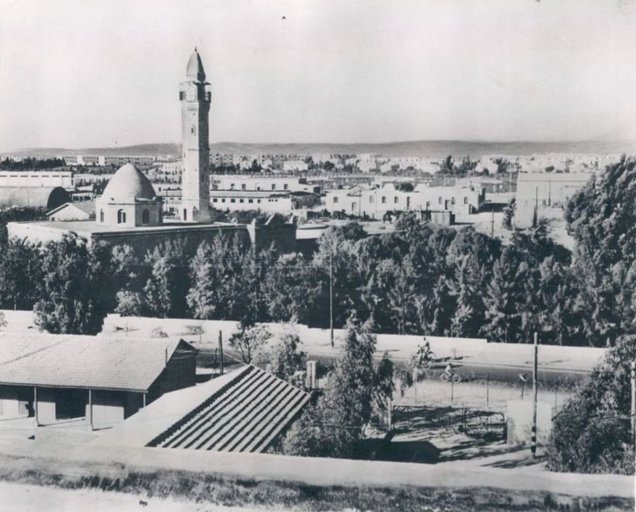
On October 21, 1948, during Operation "Yoav," Beersheba fell, a day remembered as "the breaking of Beersheba." [1] [3] The attacking forces committed a massacre of civilians who had sheltered in the town's great mosque; more than 100 detainees were sent to a forced labor camp, while the women, children and remaining Egyptian prisoners were loaded onto trucks and dumped near Gaza. [9] Among those children was Iyad al-Sarraj, who later became a well-known psychiatrist in Gaza. [9] Zionist forces then went on to occupy the Naqab as far as Umm al-Rashrash on March 10, 1949, the day the Egyptian armistice was signed. [3]
The Expulsion From the Naqab
Most of the people of Beersheba and the Naqab were driven out to Gaza, Hebron, Jordan and Sinai, some settling in al-Khan al-Ahmar and Masafer Yatta, and many were taken to the Jericho camps and then to Jordan. [2] [3] No more than 13,000 of the roughly 95,000 Bedouin of the Naqab remained, only about 10%. [3]
The expulsions did not end with the war: in November 1949 a British report noted the expulsion of 700 Azazma, and the removal of their clans to Egypt continued until 1954. [3] Those who remained were concentrated in the closed military zone known as the "Siyag," about 1,100,000 dunams, under a military rule that lasted until January 1, 1966. [3]
The Depopulated Villages and Clans of Beersheba District
Most of the "villages" of Beersheba district were not clustered stone villages but the encampments of clans spread across the Naqab. Our site lists 20 depopulated communities: some emptied in May and July 1948, most with and after the fall of the town, and some between 1949 and 1954. [1] Here are brief profiles; each has a detailed page in the depopulated villages section of our site: [1]
May–July 1948: the northwest of the district
- al-Jammama (Arab al-Atawna): about 30 km northwest of Beersheba on the edge of Wadi al-Mudabbi', with about 120 stone-and-mud dwellings, shops and a primary school opened in 1944. It was occupied on May 22, 1948, and some of its people stayed in the encampments around it.
- al-Imara: about 27 km northwest of Beersheba, near a British police station. It was occupied in May 1948, and in late September and early October its people were expelled, their livestock confiscated and their wells blown up.
- Abu Jabir (al-Jabarat): a Jabarat clan northwest of Beersheba and northeast of Gaza, numbering 500 in 1922. Its encampments were attacked on July 16–17, 1948, and its people were finally expelled on October 19.
- Asluj: about 30 km south of Beersheba on the Beersheba–al-Awja road, its people mostly from the Azazma. The Palmach attacked it on June 10–11, 1948; the Egyptian army defended it with volunteers and local people until it was finally occupied on December 25–26, 1948.
October 1948: Operation "Yoav" and the fall of the city
- Irtimat Abu al-Udus (al-Jabarat): on Wadi al-Hasi northwest of Beersheba, numbering 546 in 1931. Attacks on the Jabarat lands began in July, and its people were expelled on October 19, 1948.
- Abu Rawa' (al-Jabarat): in Wadi al-Hasi and Abu Suwayrih, near Burayr and al-Faluja. Its people were finally expelled on October 20, 1948.
- al-Khalasa: about 23 km southwest of Beersheba on the ruins of the Nabataean and Roman city of "Elusa," its people mostly Azazma, with a primary school from 1941. It was most likely depopulated in Operation "Yoav," and some of its houses remain.
- al-Qalazin (al-Tiyaha): a Tiyaha clan in the north and center of the district, numbering 480 in 1922. Its people were scattered with the fall of Beersheba in October 1948.
December 1948: Operation "Horev" on the Gaza border
- Abu Middein (al-Hanajra): one of the largest Hanajra clans, numbering 1,419 in 1931. Part of it was displaced into the Gaza Strip on December 21, 1948, and its name survives in the town of al-Maghraqa.
- al-Nuseirat (al-Hanajra): near Deir al-Balah southeast of Gaza, numbering 1,104 in 1931. Part of it was displaced on December 21, 1948, and its land remained within the Gaza Strip.
- al-Sumeiri (al-Hanajra): between Gaza and Deir al-Balah, numbering 772 in 1931. Its people were displaced on December 22, 1948.
1949–1954: the removal of the Azazma and Tiyaha clans
- al-Muhammadiyyin (al-Azazma): the largest Azazma branch, numbering 1,986 in 1931, with encampments between Beersheba, al-Khalasa and Asluj; it was from the Azazma that the Ottoman state bought the town's land. They were expelled to Egypt between 1949 and 1954, and some returned.
- al-Subhiyyin (al-Azazma): one of the ten Azazma branches, numbering 1,594 in 1931. They were expelled or moved to Egypt between 1949 and 1954.
- al-Sawakhna (al-Azazma): with encampments around Beersheba at Rakhma and Bir Muwaylih, numbering 1,350 in 1922. They were displaced between 1949 and 1954, and some returned.
- al-Mas'udiyyin (al-Azazma): one of the ten Azazma branches, numbering 926 in 1931. They were moved and removed after 1948 under pressure and harassment.
- al-Farahin (al-Azazma): with encampments at al-Hiyadiyya, Asluj and al-Awsaji, numbering 500 in 1931. They were scattered in stages during 1948.
- al-Zarba (al-Azazma): with encampments at Rakhma and Bir Ibn Turkiyya, numbering 719 in the late Mandate. They were scattered in stages, some taking refuge in Sinai.
- al-Subayhat (al-Azazma): with lands between Beersheba and Wadi Araba, numbering 226 in 1931. Part of them were moved to Egypt after 1948.
- al-Zullam – Abu Juweid (al-Tiyaha): with encampments around Beersheba at al-Khasasi, Ar'ara, al-Milh and Kuseifa, numbering 750 in 1922. Some were displaced, and those who stayed were moved and resettled under military rule.
- al-Araqib (al-Uqbi and al-Turi): north of Beersheba, between the city and Rahat. Most of its people were expelled to al-Dhahiriyya in 1948; some returned in 1949, then were removed in 1951 on the pretext of "military training" and barred from returning, and the village has been demolished again and again since 2010.
The full list, with a page for each village and clan, is on our Beersheba district page.
Beersheba After the Nakba
- A new town on the ruins: a new town with the same name was built on the ruins of Arab Beersheba, and its historic buildings were turned into museums or government offices. [1]
- The land: hundreds of thousands of dunams belonging to the people of Beersheba and the Naqab were confiscated. [1]
- Those who remained: some of the Naqab Bedouin stayed on or near their land, and many of their villages are still "unrecognized," like al-Araqib, which has been demolished again and again since 2010. [1]
Read more on our site: Hebron, Gaza and its depopulated villages and Jaffa Before the Nakba.
Conclusion
Beersheba was the capital of the Naqab: a Saraya, a railway station and a camel market, schools for Bedouin children, and tribes sowing barley and herding camels on a land that was half of Palestine. In October 1948 the town fell, and the expulsion from the Naqab went on for years after. Yet the people of the Naqab who remained still hold on to their land, rebuilding al-Araqib every time it is demolished and keeping alive the memory of "the breaking of Beersheba."
Frequently Asked Questions About Beersheba Before the Nakba
When was modern Beersheba built?
The Ottomans rebuilt it in 1900 as the center of a district, establishing the Saraya, the municipality, the barracks and the Bedouin market, and buying its land from the Azazma.
When did Beersheba fall in 1948?
It fell on October 21, 1948 during Operation "Yoav," after its people and the tribes of the Naqab defended it with few weapons; the day is remembered as "the breaking of Beersheba."
What were the tribes of Beersheba?
The Naqab had 95 clans grouped into seven main tribes: the Tarabin, Tiyaha, Azazma, Jabarat, Hanajra, Sa'idiyyin and Ahaywat.
What was the population of Beersheba district?
About 95,000 at the end of the Mandate, while the town itself had 5,570 inhabitants in 1945.
How did tribal justice work in the Naqab?
Beersheba had a tribal court that met every week and heard all disputes, even murder cases, and Aref al-Aref documented its customs in his 1933 book Justice Among the Bedouin.
What happened on the day Beersheba fell?
It was defended by a small force of volunteers and Egyptian soldiers without reinforcements; after its fall a massacre of civilians was committed, more than 100 detainees were sent to a forced labor camp, and the women and children were dumped near Gaza.
How many Naqab Bedouin remained after 1948?
No more than 13,000 of about 95,000 remained, and they were concentrated in the "Siyag" zone under military rule until 1966.
What is al-Araqib?
A Bedouin village north of Beersheba whose people were expelled in 1948 and again in 1951; they later returned, and it has been demolished again and again since 2010, with its people rebuilding it each time.
Sources and References
Arabic-language sources are listed with translated titles.
- "Beersheba," Depopulated Palestinian Villages section, Palestinina (Arabic).
- "Beersheba: The Oldest and Largest of Palestine's Historic Cities," Encyclopedia, Al Jazeera Net, 2014 (Arabic).
- Mansour Nasasra, "Beersheba District and the Palestinian South: A Story of Decades of Struggle and Steadfastness," Institute for Palestine Studies (Arabic).
- Shaimaa al-Abyad, "The First City to Fall to the British Mandate: The History of Palestinian Beersheba," Arabi Post, November 16, 2023 (Arabic).
- "Beersheba," Palestine Open Maps (Arabic).
- "Aref al-Aref," Interactive Encyclopedia of the Palestine Question, Institute for Palestine Studies.
- "The City of Beersheba," Palestinian Villages Encyclopedia (Arabic).
- Aref al-Aref, The History of Beersheba and Its Tribes, Jerusalem, 1934, Birzeit University Digital Library (Arabic).
- "Beersheba, Capital of the South," Palestinian Information Center, January 19, 2013 (from Al-Safir, January 18, 2013) (Arabic).
- Nidaa Bassoumi, "The Naqab: A Palestinian History Full of the Legitimacy of Presence," Noon Post, June 17, 2022 (Arabic).
- "Martyrs of the 1936–1939 Revolt," Palestinian National Information Center – WAFA (Arabic).
More from the archive
 Download Our Palestine App
The whole archive in the palm of your hand: depopulated villages, the Nakba, the massacres and Al-Aqsa — free, with no ads to erase the story.
Comments
No comments yet — be the first to write one.
Add your comment
Name and email are optional. Comments appear after review.