
The depopulated village of Fajja / District of Jaffa
Subdistrict: Jaffa
Palestinian population in 1945: 1,200
Estimated Palestinian population in 1948: 1,392
Date of final depopulation: 15 May 1948
Military forces involved: Haganah, Palmach and Irgun units
Settlements established on the village lands before 1948: Petah Tikva had expanded near Fajja; some local compilations associate the Belinson area with its lands, although the principal Palestinian references do not establish the precise cadastral relationship.
Construction on the village site after 1948: The ‘Ammishav transit camp was established on the site in the early 1950s. The area was subsequently incorporated into the eastern suburbs of Petah Tikva, including the present-day ‘Ammishav–Hadar Ganim area.
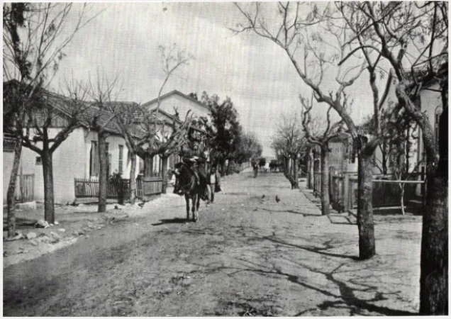
Fajja was a depopulated Palestinian village in the Jaffa Subdistrict. It was situated approximately 15 kilometres northeast of the city of Jaffa, on relatively level ground in the central coastal plain.
The main road connecting Jaffa and al-Lydd passed near the village. Fajja stood about one kilometre east of Petah Tikva, a Zionist settlement established in 1878 west of the village. In the late nineteenth century, Fajja was described as a small settlement whose houses were built mainly of adobe. During the British Mandate, some newer houses were constructed of concrete. The village’s Palestinian inhabitants were Muslims, and it had an elementary school.
Boundaries of Fajja
Fajja was situated among the following Palestinian villages and towns:
- North: al-Mirr (al-Mahmudiyya).
- Northwest: al-Sawalima.
- West: al-Jammasin al-Sharqi.
- Southwest: al-Khayriyya.
- South: Rantiya.
- Southeast: al-Muzayri‘a.
- East: Majdal Yaba (Majdal al-Sadiq).
- Northeast: Kafr Qasim.
Population of Fajja
| Year | Palestinian population | Jewish population included in the statistical unit | Total |
|---|---|---|---|
| 1922 | 194 | — | 194 |
| 1931 | 707 | — | 707 |
| 1945 | 1,200 | 370 | 1,570 |
| 1948 | 1,392 (estimate) | Not included in the Palestinian refugee estimate | — |
| Estimated Palestinian refugees and descendants in 1998 | 8,548 | — | 8,548 |
The 1945 statistical total of 1,570 combined 1,200 Palestinian Arab residents with 370 Jewish residents recorded within the wider statistical unit. The figure of 1,392 for 1948 is a retrospective estimate of Fajja’s Palestinian population and should not be presented as a total that includes the 370 Jewish residents.
Land Ownership in Fajja
| Ownership category | Land area (dunams)* |
|---|---|
| Palestinian ownership | 3,215 |
| Jewish ownership | 1,580 |
| Public land | 124 |
| Total | 4,919 |
* One dunam equals approximately 1,000 square metres.
Land Use in Fajja in 1945
| Land-use category | Palestinian ownership (dunams)* | Jewish ownership (dunams)* | Public land (dunams)* | Total (dunams)* |
|---|---|---|---|---|
| Citrus and banana cultivation | 602 | 166 | 0 | 768 |
| Irrigated land and orchards | 53 | 8 | 0 | 61 |
| Cereal cultivation | 2,457 | 1,406 | 0 | 3,863 |
| Built-up area | 7 | 0 | 0 | 7 |
| Cultivable land | 3,112 | 1,580 | 0 | 4,692 |
| Uncultivated land | 96 | 0 | 124 | 220 |
* One dunam equals approximately 1,000 square metres.
Number of Houses in Fajja
| Year | Number of houses |
|---|---|
| 1931 | 165 |
| 1948 | 324 (estimate) |
Education in Fajja
Fajja had an elementary school for boys that opened in 1922. By 1945, it enrolled 181 pupils, including 10 girls. Some reproductions of Walid Khalidi’s village entry give the total as 781, but this appears to be a transcription or typographical error; the figure of 181 is reported in the village’s statistical summary and is more consistent with its population and school facilities.
Economic Life in Fajja
Agriculture formed the basis of village life. The inhabitants cultivated cereals, vegetables, citrus fruit and bananas on most of their land. In 1944/45, 602 dunams under Palestinian ownership were devoted to citrus fruit and bananas, 2,457 dunams to cereals, and 53 dunams were irrigated or used for orchards. Cultivation depended on both rainfall and water drawn from wells.
Archaeological Remains in Fajja
Fajja was built over an archaeological site containing fragments of stone columns and capitals, building foundations and a cistern. These remains indicate that the location had been inhabited in earlier historical periods, although the available village references do not provide a definitive date for the site.
Attacks, Occupation and Depopulation of Fajja
Attacks on Fajja began before the broad military campaigns of the Nakba. On 20 May 1947—not 20 May 1948 as stated in some versions of the article—a Palmach unit entered the village, reportedly seeking suspects in the killing of two people from Petah Tikva. The unit approached a village coffeehouse where the suspects were alleged to be present, opened fire and planted an explosive charge that destroyed the building.
Accounts of the casualties differ. The History of the Haganah, as summarized by Walid Khalidi, states that two villagers were killed during the shooting. The Book of the Palmach claims that no one was injured by the subsequent explosion. A local Palestinian account instead reports that four Egyptian workers were killed and seven villagers wounded. Because these accounts conflict, no single casualty figure should be treated as conclusive.
The Irgun launched another documented attack on 17 February 1948, after which part of the population left. Benny Morris reports that Fajja was repeatedly attacked by Haganah and Irgun forces during the first months of 1948. By May, only several dozen residents reportedly remained.
On 9 May, Haganah intelligence officers decided that the remaining population should be removed. According to a contemporary intelligence report cited by Khalidi and Morris, the last inhabitants departed on 15 May 1948 under military and psychological pressure, including a Haganah “whispering” campaign. Fajja’s depopulation was therefore a gradual process culminating on 15 May, rather than a single occupation on 1 May.
During June 1948, the Jewish National Fund initiated the village’s demolition. On 14 June, Ezra Danin, a senior Haganah intelligence officer and Jewish Agency official, informed Jewish National Fund official Yosef Weitz of the progress made in destroying Fajja. On 16 June, David Ben-Gurion recorded in his diary that Fajja and two other Palestinian villages had been demolished.
Construction on the Lands and Site of Fajja
Petah Tikva, established in 1878 west of Fajja, expanded eastward after the Nakba and eventually absorbed the village site and much of its surrounding land. The principal Palestinian references identify Petah Tikva as the urban area that now occupies Fajja’s lands.
In the early 1950s, the former village site was used for a transit camp for newly arrived Jewish immigrants known as ‘Ammishav. The site subsequently became part of Petah Tikva’s eastern suburbs. Present-day neighbourhoods associated with the broader area include ‘Ammishav and Hadar Ganim; local compilations also identify Yoseftal and Kiryat David El‘azar. The precise cadastral relationship between every modern neighbourhood and Fajja’s former boundaries requires comparison with detailed Mandate-period land-demarcation maps.
Fajja Today
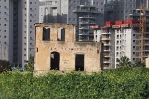
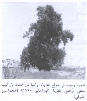
The village was almost entirely demolished. According to Walid Khalidi’s field survey, only one house and a pond remained identifiable. Eucalyptus trees and cactus plants mark parts of the site. Buildings cover some of the former village land, while the remaining open areas are cultivated.
Sources
- PalQuest, “Fajja”.
- Palestine Remembered, “Fajja—Jaffa”.
- Palestine Remembered, “The Palestinian Village of Fajja”.
- Visualizing Palestine, “The Story of Fajja”.
- Our Palestine, “The Depopulated Village of Fajja”.
- Walid Khalidi, ed., All That Remains: The Palestinian Villages Occupied and Depopulated by Israel in 1948, Institute for Palestine Studies, 1992.
- Government of Palestine, Census of Palestine, 1922.
- Government of Palestine, Census of Palestine, 1931.
- Government of Palestine, Village Statistics, April 1945.
- Benny Morris, The Birth of the Palestinian Refugee Problem Revisited, Cambridge University Press, 2004.
Photo gallery


Photos from the village's people
Photos sent in by visitors and published after review.
Add a photo of this village
Log in to add photos of this village.
Other villages from Jaffa
 Download Our Palestine App
The whole archive in the palm of your hand: depopulated villages, the Nakba, the massacres and Al-Aqsa — free, with no ads to erase the story.
Download Our Palestine App
The whole archive in the palm of your hand: depopulated villages, the Nakba, the massacres and Al-Aqsa — free, with no ads to erase the story.



Comments
No comments yet — be the first to write one.
Add your comment
Name and email are optional. Comments appear after review.