
The depopulated village of Al-Mas'udiyya (Summayl) / District of Jaffa
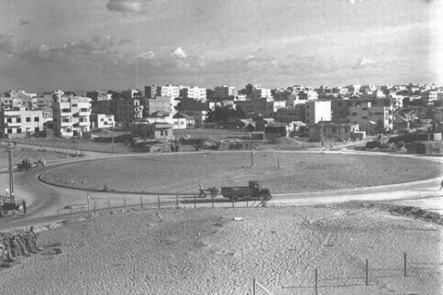
Al-Mas'udiyya (Summayl)
About the depopulated village of Al-Mas'udiyya (Summayl)
- District
- Jaffa
- Date Al-Mas'udiyya (Summayl) was occupied
- 25 December 1947
- Population in 1948
- 986
- Brigade that carried it out
- The sources identify no unit that attacked or occupied the village; Khalidi notes that the area was the scene of numerous Haganah and Irgun operations in the winter and early spring
- Distance from the governorate centre
- 5 km northeast of Jaffa
- Elevation above sea level
- 25 m
- Cause of displacement
- Fear of a Zionist attack, given the village's location only a few hundred yards from the outskirts of Tel Aviv at a time when attacks on Arab villages were increasing, according to Morris as cited by Khalidi
- Extent of destruction
- al-Mas'udiyya was mostly destroyed with the exception of a deserted house that belonged to Muhammad Baydas.
- Ethnic cleansing
- Despite of a peace truce between the villagers and the Haganah, the villagers were terrorized into fleeing on 25th of December 1947.
- Settlements built on the built-up area of Al-Mas'udiyya (Summayl) after 1948
- Khalidi states that there are no Israeli settlements on village lands, but the expansion of Tel Aviv has encroached on them
- Refugees' migration routes
- Initially, many refugees sought refuge in the neighboring Jammasin, but later they were on the move again.
Hover a dot to read the village name, or click to open its card.
Borders of the depopulated village of Al-Mas'udiyya (Summayl)
al-Mas'udiyya (Summayl): A Depopulated Palestinian Village in the Jaffa District
Al-Mas'udiyya, also known as Summayl, was a depopulated Palestinian village in the Jaffa District. It was located approximately 5 kilometers northeast of Jaffa on the central coastal plain, at an average elevation of about 25 meters above sea level.
- Subdistrict
- Jaffa
- Distance from district center
- 5 km northeast of Jaffa
- Average Elevation
- 25 m above sea level
- Population in 1931
- 658
- Number of Houses in 1931
- 127
- Population in 1944/1945
- 850 – predominantly Muslim, including 20 Christians
- Estimated Population in 1948
- About 986 – a later demographic estimate, not an official census
- Attack and Depopulation
- Although the village had agreed to a truce with the Haganah towards the end of 1947, it was one of the first villages to be evacuated, on 25 December 1947, because its inhabitants feared a Zionist attack given its proximity to the outskirts of Tel Aviv and the increasing attacks on Arab villages, according to Morris as cited by Khalidi. The villagers fled first to neighbouring al-Jammasin, which was itself completely emptied by mid-March 1948.
- Final Israeli Control
- The sources give no date on which Zionist forces took control of the village; it was evacuated on 25 December 1947, and the area was the scene of numerous Haganah and Irgun operations in the winter of 1947–1948 and early spring 1948
- Military Unit
- The sources identify no unit that attacked or occupied the village; Khalidi notes that the area was the scene of numerous Haganah and Irgun operations in the winter and early spring
- Cause of Depopulation
- Fear of a Zionist attack, given the village's location only a few hundred yards from the outskirts of Tel Aviv at a time when attacks on Arab villages were increasing, according to Morris as cited by Khalidi
- Settlements Documented on Village Lands
- Khalidi states that there are no Israeli settlements on village lands, but the expansion of Tel Aviv has encroached on them
The Government of Palestine's 1944/1945 statistics recorded 850 inhabitants, the overwhelming majority of whom were Muslims, with 20 Christians. The village was increasingly affected by the expansion of Tel Aviv before the Nakba, and a number of inhabitants had already left by 1946. On 25 December 1947, al-Mas'udiyya was evacuated and its inhabitants were displaced amid growing fear of a Zionist attack and escalating military operations in the surrounding area. The principal sources do not document a specific military assault or identify one unit as having captured the village on that date.
Key Facts About al-Mas'udiyya
- District: Jaffa.
- Alternative name: Summayl.
- Distance from Jaffa: approximately 5 kilometers northeast.
- Average elevation: approximately 25 meters above sea level.
- Population in 1944/1945: 850.
- Main date of depopulation: 25 December 1947.
- Military unit: no specific attacking unit is documented for that date; the surrounding area subsequently witnessed operations by both the Haganah and Irgun.
- Israeli settlements established specifically on village lands: none identified by Walid Khalidi or PalQuest; the expansion of Tel Aviv later engulfed the site.
Location of al-Mas'udiyya
Al-Mas'udiyya stood on flat, sandy terrain in Palestine's central coastal plain, approximately 1.5 kilometers east of the Mediterranean coast and 1.5 kilometers south of the al-'Awja River.
The village lay along the eastern edge of the coastal sand dunes and was among the Palestinian villages closest to the northeastern expansion of Tel Aviv.
Palestinian local sources also record Wadi Musrara as passing east of the village area and connecting with the al-'Awja River system.
Surrounding Villages and Localities
Al-Mas'udiyya was situated among several Palestinian villages and nearby localities, including:
- al-Shaykh Muwannis to the north.
- al-Jammasin al-Gharbi in the northern sector.
- Qabbaniyat to the east.
- Sarona to the southeast.
- Jaffa and the expanding Tel Aviv urban area to the south and southwest.
- The Mediterranean coast to the west.
The Names al-Mas'udiyya and Summayl
The village was originally and widely known as Summayl. The name al-Mas'udiyya became common in the early twentieth century.
Palestinian documentation sometimes refers to it as “Summayl of Jaffa” to distinguish it from the Palestinian village of Summayl in the Gaza District.
The Built Environment of al-Mas'udiyya
In the 1870s, Summayl was described as an ordinary village of adobe and mud houses with a large well and a cave.
The houses were closely clustered along a line running from north to south, reflecting the narrow shape of the village's built-up area.
Palestinian local sources record approximately 2,091 dunums of village land in 1938, while the built-up village itself covered only about 9 dunums. The figure of roughly ten dunums therefore refers to the built-up area rather than the total lands of al-Mas'udiyya.
The Lands of al-Mas'udiyya
The Palestinian Villages Encyclopedia records a total area of approximately 2,091 dunums for al-Mas'udiyya in 1938 and a built-up area of about 9 dunums.
The published 1945 Village Statistics tables do not provide a completed land-ownership and land-use entry for al-Mas'udiyya. A 1945 land table is therefore not reconstructed here from unsupported figures.
The agricultural figure clearly documented by Walid Khalidi is that the villagers cultivated approximately 275 dunums with citrus trees in 1938.
Population of al-Mas'udiyya
The official 1922 Census of Palestine recorded 449 inhabitants in al-Mas'udiyya: 443 Muslims and 6 Christians.
In the 1931 census, the population increased to 658 inhabitants living in 127 houses.
The Government of Palestine's 1944/1945 statistics recorded 850 inhabitants. PalQuest notes that 20 of them were Christians, with the remainder predominantly Muslim.
The figures of 986 inhabitants for 1948 and 6,055 refugees for 1998 published by Palestine Remembered are later demographic estimates rather than official Government of Palestine censuses.
Population of al-Mas'udiyya
- 1922449Official census: 443 Muslims and 6 Christians
- 1931658Official census under the British Mandate
- 1944/1945850Government of Palestine statistics; including 20 Christians
- 1948986Later estimate published by Palestine Remembered
- 19986,055Later refugee-population estimate published by Palestine Remembered
Number of Houses in al-Mas'udiyya
The 1931 census recorded 127 houses in al-Mas'udiyya.
The figure of 190 houses for 1948 published by Palestine Remembered is a later estimate rather than the result of an official census conducted in 1948.
Number of Houses in al-Mas'udiyya
- 1931127Official census
- 1948190Later estimate published by Palestine Remembered
Education in al-Mas'udiyya
An elementary school for boys was established in al-Mas'udiyya in 1931.
By the mid-1940s, it had an enrollment of 31 pupils, reflecting the relatively small size of the village compared with the larger communities surrounding Jaffa.
The Mosque and the Earlier Religious Structure
Al-Mas'udiyya had a mosque constructed over the remains of an earlier building that Walid Khalidi suggests may have been a church.
Palestine Remembered's structured table separately lists both a mosque and a church. Khalidi's narrative, however, does not confirm the existence of a separate functioning church immediately before the Nakba, referring instead to the possible earlier church beneath the mosque. This discrepancy is therefore preserved rather than presenting the existence of two separate functioning religious buildings as certain.
Economic Life in al-Mas'udiyya
The people of al-Mas'udiyya depended primarily on citrus cultivation and animal husbandry. A smaller number worked in commerce, handicrafts, and the service sector.
In 1938, approximately 275 dunums were planted with citrus trees.
The village's proximity to Jaffa, Tel Aviv, and the road network of the coastal plain also provided direct access to regional markets, employment, and services.
The Expansion of Tel Aviv Before the Nakba
Al-Mas'udiyya stood extremely close to the expanding urban edge of Tel Aviv, with only a short distance separating the village from the city's outskirts.
Walid Khalidi records that pressure from the expansion of Tel Aviv led many villagers to leave al-Mas'udiyya by 1946, before the large-scale displacement of Palestinians that began in late 1947.
The contraction of the Palestinian community at al-Mas'udiyya therefore began gradually before the village's principal depopulation in December 1947.
The Truce with the Haganah in Late 1947
Walid Khalidi, citing the History of the Haganah, records that al-Mas'udiyya agreed to a truce with the Haganah after a meeting in Petah Tikva toward the end of 1947.
The agreement did not prevent mounting fear in a village located only a short distance from the outskirts of Tel Aviv at a time when attacks and military operations against Palestinian communities were increasing.
This information is presented through the Palestinian intermediary source Khalidi/PalQuest rather than through independent reliance on the Haganah account.
The Depopulation of al-Mas'udiyya on 25 December 1947
Al-Mas'udiyya was among the earliest Palestinian villages to become depopulated during the initial phase of the Nakba. Its inhabitants left on 25 December 1947.
The principal sources do not describe the event as a battle ending in a documented military seizure of the village on that date. Walid Khalidi, citing Benny Morris, states that the villagers left because they feared an attack, given al-Mas'udiyya's precarious location only a few hundred meters from the outskirts of Tel Aviv and the increasing attacks against Palestinian villages.
It is therefore more precise to describe 25 December 1947 as the date of the village's evacuation and depopulation rather than simply its “occupation date.”
The sources likewise do not identify one military formation that carried out a capture or expulsion operation at al-Mas'udiyya on that day. The wider area was the scene of numerous Haganah and Irgun operations during the winter and early spring, but this general activity should not be converted into the name of a specific “occupying unit” for 25 December.
The Displacement Route of al-Mas'udiyya's Inhabitants
According to the account cited by Walid Khalidi, many villagers initially sought refuge in neighboring al-Jammasin.
Al-Jammasin itself was later subjected to mounting pressure and was completely emptied by mid-March 1948, forcing refugees from al-Mas'udiyya to move again.
For many families, displacement from al-Mas'udiyya was therefore not a single movement to a place of safety but the beginning of repeated displacement during the first months of the Nakba.
Occupation and Depopulation Chronology
- By 1946
Departure of many villagers under pressure from Tel Aviv's expansion
The pressure of an expanding Tel Aviv led many of the villagers to leave al-Mas'udiyya by 1946, according to Khalidi.
- Late 1947
Truce with the Haganah
The village agreed to a truce with the Haganah after a meeting in Petach Tiqwa, according to the History of the Haganah as cited by Khalidi.
- 25 December 1947
Depopulation of the village
Despite the truce, al-Mas'udiyya was one of the first villages to be evacuated, because its inhabitants feared a Zionist attack given its location only a few hundred yards from the outskirts of Tel Aviv and the increasing attacks on Arab villages at the time, according to Morris as cited by Khalidi. The villagers fled first to neighbouring al-Jammasin, where the arrival of the refugees lowered morale.
- By mid-March 1948
Evacuation of al-Jammasin, the villagers' first refuge
Al-Jammasin, where the people of al-Mas'udiyya had first taken refuge, was completely emptied by mid-March 1948, according to Morris as cited by Khalidi. The area was the scene of numerous Haganah and Irgun operations in the winter and early spring.
Israeli Settlements and Urban Expansion on Village Lands
Walid Khalidi and PalQuest do not identify any separately named Israeli settlement established on the lands of al-Mas'udiyya after its depopulation.
Instead, the urban expansion of Tel Aviv gradually engulfed the village site and its lands, incorporating them into the city's built-up fabric.
Descriptions such as “Tel Aviv neighborhoods” therefore refer to the later urban development of the village site and should not be presented as a list of separately founded settlements on al-Mas'udiyya's lands.
The Site of al-Mas'udiyya After the Nakba
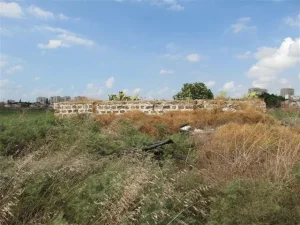
According to the field description recorded by Walid Khalidi for All That Remains, the village site had become part of Tel Aviv. At the time of the survey, one deserted house belonging to Muhammad Baydas remained.
Cactuses, castor-oil plants, palm trees, and cypress trees also marked the site. Nearby stood the al-Mas'udiyya, or Summayl, Bridge, an arched steel structure.
Palestinian local sources additionally record surviving houses associated with the Abu Jabara and Abu 'Ayta families. This differs from Khalidi's field description, which identifies only the Baydas house, possibly reflecting differences in survey date or in how surviving village structures were classified.
These descriptions date from earlier field documentation and should not necessarily be treated as an updated survey of the site today.
Sources
- PalQuestPalQuest – Interactive Encyclopedia of the Palestine Question: al-Mas'udiyya
- Institute for Palestine StudiesInstitute for Palestine Studies: Walid Khalidi, All That Remains
- Palestine RememberedPalestine Remembered: al-Mas'udiyya (Summayl) – Jaffa District
- palqura.comPalestinian Villages Encyclopedia: al-Mas'udiyya / Summayl
- pal48.psFilastunna: al-Mas'udiyya (Summayl) – Palestinian Local Documentation
- users.cecs.anu.edu.auGovernment of Palestine: Census of Palestine, 1922
- palmap.linkSami Hadawi: Village Statistics 1945
Photo gallery


Photos from the village's people
Photos sent in by visitors and published after review.
Add a photo of this village
Log in to add photos of this village.
Other villages from Jaffa
More from the archive
 Download Our Palestine App
The whole archive in the palm of your hand: depopulated villages, the Nakba, the massacres and Al-Aqsa — free, with no ads to erase the story.
Download Our Palestine App
The whole archive in the palm of your hand: depopulated villages, the Nakba, the massacres and Al-Aqsa — free, with no ads to erase the story.



Comments
No comments yet — be the first to write one.
Add your comment
Name and email are optional. Comments appear after review.