Solomon's Cave (Maghara al-Kattan)
Solomon's Cave (Maghara al-Kattan)
Solomon's Cave (Maghārat al-Kattān), Jerusalem: The Quarry That Built the City
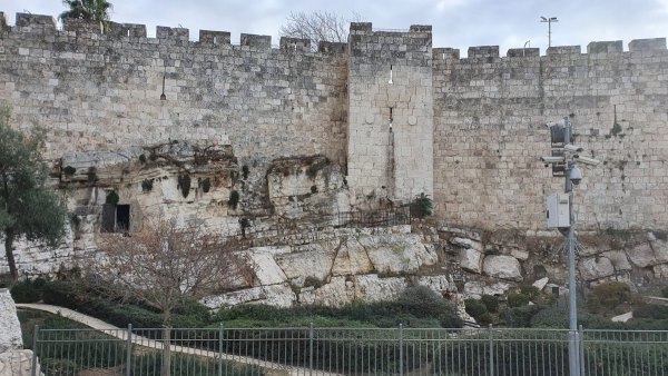
Solomon's Cave, known by its older Arabic name Maghārat al-Kattān (the Flax Cave), is the largest rock cavity beneath the Old City of Jerusalem. Its entrance lies below the northern wall, to the left as you enter Bab al-Amud (Damascus Gate), and it extends about 300 metres under the city's houses between Bab al-Amud and Bab al-Sahira, covering some 9,000 square metres. Known since Canaanite times, it was a major quarry in the Islamic eras for the stone of Jerusalem's buildings, and the stones of the Ottoman wall were cut from it under Sultan Suleiman the Magnificent, after whom it is named. Since the occupation of East Jerusalem in 1967, the occupation municipality has turned it into a tourist site promoting a biblical narrative, and hosts concerts and events there that Jerusalemites describe as part of the Judaisation of the place. This guide covers its names, its history and its reality today.
Quick facts
| Arabic name | مغارة سليمان / مغارة الكتان |
|---|---|
| Other names | Cave of al-Kattan (flax), Cave of al-Qutn (cotton), the Royal Quarries |
| Location | Below the northern wall of the Old City, left of Bab al-Amud (Damascus Gate) |
| Extent | About 300 m under the Old City's houses, between Bab al-Amud and Bab al-Sahira |
| Area | About 9,000 m² (9 dunams) |
| Width and height | Up to about 100 m wide and 15 m high |
| Type | Ancient stone quarry; only the entrance is natural |
| Earliest Arabic mention | Al-Muqaddasi, Ahsan al-Taqasim (10th century CE) |
| Ottoman period | Stones for Jerusalem's wall cut under Suleiman the Magnificent |
| Management today | The occupation municipality, as a tourist site since after 1967 |
The names
- Maghārat al-Kattān (or al-Qutn): its oldest Arabic name. The geographer al-Muqaddasi mentioned it in the 10th century CE in Ahsan al-Taqasim fi Ma'rifat al-Aqalim, and some five centuries later Mujir al-Din al-Hanbali called it "Maghārat al-Kattān". According to Jerusalem researcher Fouad Qteineh, the name comes from flax and cotton being stored there at one time.
- Solomon's Cave: named after the Ottoman Sultan Suleiman the Magnificent, under whom the stones of Jerusalem's wall were cut from it. Its association with the Prophet Solomon came from 19th-century Western orientalists who relied on the biblical narrative.
- The occupation's name: the occupation authorities give it a biblical name and weave myths around it, while Palestinian sources hold to its two Arabic names.
Location
The entrance lies below the northern wall of the Old City of Jerusalem, east of Bab al-Amud and to the left as you enter it. From there the cave runs south beneath the Old City's houses and alleys between Bab al-Amud and Bab al-Sahira. Its closeness to the wall made it easy to cut stone and carry it to the great buildings inside the city.
Nature and size
Only the entrance is natural; the rest of the cave is a rock cavity carved by human hands over many centuries, in periods not yet precisely dated. It covers about 9,000 square metres and extends some 300 metres beneath the Old City's houses, reaching about 100 metres in width and up to about 15 metres in height. Tool marks from the stone-cutting are still visible on its walls, and water drips from its ceiling.
History through the ages
- Antiquity: Palestinian sources describe it as a Canaanite landmark, known since that era. It is still impossible to determine when quarrying began, because the occupation authorities bar Palestinian researchers from excavating.
- Islamic eras: it was a major quarry for the massive stones of Jerusalem's Arab and Islamic buildings, described by al-Muqaddasi in the 10th century and by Mujir al-Din al-Hanbali in the 15th.
- Ottoman period: under Sultan Suleiman the Magnificent its stones were cut to restore and build Jerusalem's wall over three years, after which it was closed, according to Al Jazeera's encyclopedia.
- Until the mid-19th century: it served as a secret shelter for followers of the three faiths and various associations.
- 1854: the American missionary James Barclay came upon it by chance and linked it to Old Testament texts in his book The City of the Great King.
- 1873: the French orientalist Charles Clermont-Ganneau excavated it and promoted its link to the Prophet Solomon, and the British officer Claude Conder included it on his maps of Palestine. Since the last third of the 19th century a Masonic lodge has held ceremonies there, believing it connected to the biblical narrative.
- 1948–1967: the cave lay in the part of Jerusalem under Jordanian administration.
Under occupation since 1967
Israeli forces occupied East Jerusalem in June 1967, and Israel later declared it annexed, a step UN Security Council Resolution 478 declared null and void. After the occupation the occupation municipality opened the cave to tourism, restored it in 1989 and placed it on its "cultural heritage" list. Jerusalem researchers see this as part of an effort to Judaise the site and erase its identity:
- The narrative: the municipality put up signs in Arabic, English and Hebrew attributing the cave's stone to the Prophet Solomon and to biblical-era periods. Researcher Hani Nur al-Din says this reflects the orientalists' reliance on the biblical narrative, while the cave's Arab and Islamic history and its name "al-Kattan" are sidelined.
- Barring Palestinian research: the occupation authorities bar Palestinian researchers from excavating in the cave, leaving its story in Israeli hands alone.
- Concerts and events: according to the Jerusalem media centre Q Press, in 2016 the occupation municipality and the Israeli Ministry of Tourism staged cheap night-time concerts by Israeli artists inside the cave, under the supervision of official bodies and settler-linked organisations and companies. The municipality's annual "Festival of Light" also passes through nearby Bab al-Amud, which Jerusalemites see as an attempt to falsify the city's identity.
The cave today (2026)
The cave remains a tourist site run by the occupation municipality. A few steps away stands Bab al-Amud, the main gateway for Palestinians to the Old City and al-Aqsa Mosque, which sees a heavy deployment of occupation police, checkpoints and frequent arrests. These intensified during the closure of al-Aqsa and the Old City under the state of emergency imposed from 28 February 2026.
Legal protection
The cave extends beneath the Old City of Jerusalem and its walls, which are on UNESCO's List of World Heritage in Danger. As part of occupied East Jerusalem, it is protected by the Fourth Geneva Convention and the 1954 Hague Convention for the Protection of Cultural Property, which forbid an occupying power from altering the character of cultural sites, while UN Security Council Resolution 478 rejects the annexation of East Jerusalem.
Frequently asked questions
Where is Solomon's Cave?
Below the northern wall of Jerusalem's Old City, to the left as you enter Bab al-Amud (Damascus Gate), extending under the houses between Bab al-Amud and Bab al-Sahira.
Why is it called the Flax Cave (Maghārat al-Kattān)?
Because flax and cotton were stored there at one time. Mujir al-Din al-Hanbali used this name, and al-Muqaddasi mentioned the cave before him in the 10th century CE.
Is Solomon's Cave named after the Prophet Solomon?
The Arabic name refers to the Ottoman Sultan Suleiman the Magnificent, under whom the stones of Jerusalem's wall were cut from it. Its link to the Prophet Solomon came from 19th-century Western orientalists.
How big is Solomon's Cave?
About 9,000 square metres, extending some 300 metres under the Old City, up to 100 metres wide and 15 metres high.
Who runs Solomon's Cave today?
The occupation municipality, which opened it to tourism after the occupation of East Jerusalem in 1967 and presents it through a biblical narrative, while Palestinian researchers are barred from excavating there.
Conclusion
From the stone of Maghārat al-Kattān rose Jerusalem's houses, its monuments and its Ottoman wall over the centuries. Today the quarry that built the city stands at the heart of a struggle over its name and its story, a reminder that the occupation has not left even the rock beneath Jerusalem without contesting its identity.
More from the archive
 Download Our Palestine App
The whole archive in the palm of your hand: depopulated villages, the Nakba, the massacres and Al-Aqsa — free, with no ads to erase the story.

Comments
No comments yet — be the first to write one.
Add your comment
Name and email are optional. Comments appear after review.