
The depopulated village of Asluj / District of Bir-a-Saba (Beer Sheva)
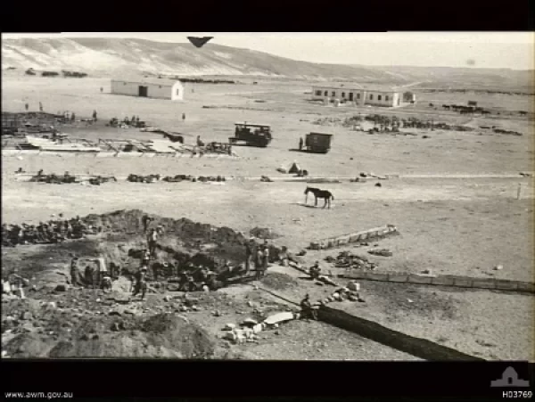
About the depopulated village of Asluj
- District
- Bir-a-Saba (Beer Sheva)
- Date Asluj was occupied
- 11 June 1948
Hover a dot to read the village name, or click to open its card.
Asluj – Depopulated Palestinian Locality in the Beersheba Subdistrict
Asluj, frequently referred to as Bir 'Asluj and rendered as 'Asluj in some Arabic sources, was a semi-settled Palestinian Bedouin locality in the Beersheba Subdistrict. It lay approximately 30 kilometers south of Beersheba in the central Negev, along Wadi 'Asluj and the principal road connecting Beersheba with al-'Auja and Sinai.
Its inhabitants were associated primarily with the 'Azazma tribes. Although the civilian settlement was relatively small, Asluj had considerable regional importance because of its wells, shops, mosque, school, police station, road junction, and its proximity to the Ottoman-era railway route.
Asluj passed through several military stages in 1948. Israeli forces first captured its strategic position in June, but control of the area subsequently changed. The final Israeli capture of the Asluj sector took place on 25–26 December 1948 during Operation Horev.
Basic Information
| Field | Information |
|---|---|
| Name | Asluj / Bir 'Asluj |
| Arabic | عسلوج / بئر عسلوج |
| Alternative Arabic rendering | عصلوج |
| Subdistrict | Beersheba |
| Region | Central Negev |
| Distance from Beersheba | Approximately 30 km south |
| Population type | Semi-settled Bedouin population, principally associated with the 'Azazma |
| Official independent population in 1945 | No separately documented village figure is available in the Government of Palestine Village Statistics; most Bedouin inhabitants of the district were recorded under tribal units |
| Later 1945 estimates | Palestinian secondary sources differ, giving approximately 500 in one source and 150 in another |
| Village land area | No reliable independent village-level total is provided in Village Statistics 1945 |
| First major attack | Night of 10–11 June 1948 |
| Unit in first attack | 8th Battalion, Negev Brigade |
| Final occupation | 25–26 December 1948; 26 December is used here as the final occupation date |
| Final operation | Operation Horev |
| Main force in the Asluj sector | Negev Brigade |
| Cause of depopulation | Palestine Remembered classifies it as military assault; the precise date on which all civilian residents left is not independently documented |
| Destruction | Largely destroyed; identifiable ruins and historical remains have been documented |
Name
The Palestine Encyclopedia explains the Arabic word al-'asluj as referring to a soft or flexible tree branch. The form Bir 'Asluj, “the well of Asluj,” occurs frequently in military and historical sources because of the importance of water wells at the site. The spelling 'Asluj also appears in modern Palestinian references.
Location and Geography
Asluj stood on undulating terrain in the central Negev, in a broad watershed region between drainage systems flowing eastward toward the Arabah and those flowing westward toward the Mediterranean.
Its position on the paved Beersheba–al-'Auja road was especially important. The route connected the Negev with Sinai and was used by local inhabitants, Bedouin groups, commercial traffic, and later military forces.
The locality was also associated geographically with Bir Thamila and with the wider territory inhabited and used by the 'Azazma tribes.
Built Environment
Asluj was not a densely built agricultural village of the type common in the coastal plain or Galilee. It consisted of tents and houses belonging to Bedouin families who had become partly settled along Wadi 'Asluj.
Palestinian sources state that the Ottoman authorities built a mosque at the locality. Asluj also contained several shops that sold food, cloth, and other necessities to neighboring Bedouin communities, which in turn brought livestock products to the local market.
A police post and facilities connected with the main road and nearby railway added to the locality's regional importance.
Water Resources
Water was central to the development of Asluj. Palestinian reference works record three wells containing fresh water at Asluj itself.
Bir Thamila lay in a valley southwest of Asluj and was another important water point. Local tradition associates the vicinity with a traditional site connected to the story of Ishmael, but this tradition should not be treated as archaeological proof.
Population and Statistical Problems
The residents of Asluj were semi-settled Bedouins, principally associated with the 'Azazma and with groups including the 'Usayyat/Abu 'Asa families.
Establishing an exact population figure is difficult. The Government of Palestine's 1945 statistics did not list Asluj as an independent population unit. Most Bedouin residents of the Beersheba Subdistrict were instead recorded collectively under tribal units.
| Year | Population | Status |
|---|---|---|
| 1945 | No separate figure available | The Government of Palestine statistics do not provide an independent population total for Asluj |
| 1945 | Approx. 500 | Later estimate reported by a Palestinian village encyclopedia; not an independent official census figure |
| 1945 | Approx. 150 | Different figure published by a PLO refugee-affairs source; not an independent official census figure |
Accordingly, neither 500 nor 150 should be described as the official 1945 population of Asluj. The surviving Palestinian secondary sources disagree, while the Mandate statistics do not provide a separate village total.
Land and Ownership
Village Statistics 1945 does not provide a separate Asluj table from which a reliable village-level land ownership or land-use breakdown can be constructed.
This reflects the particular statistical and cadastral situation of the Beersheba Subdistrict. Large portions of the district had not undergone the cadastral survey and land-settlement process applied elsewhere in Palestine, while Bedouin landholding and use continued to be regulated extensively through local and customary systems.
For this reason, this article does not fabricate a Palestinian / Transferred to Zionists / Public ownership table for Asluj where no corresponding independent official village table has been located.
Economy and Agriculture
Agriculture around Asluj was limited by the arid environment and low rainfall, which Palestinian reference works estimate at approximately 70 millimeters annually. Barley was among the principal crops because of its relative resistance to drought.
Livestock raising was more important. Residents kept camels, sheep, and goats and depended on the natural grazing lands of the surrounding Negev.
The locality's small commercial center also served neighboring Bedouin groups, who sold animal products and purchased food, cloth, and other necessities.
School
Palestinian sources state that an elementary school was established at Asluj in 1946 along the main Beersheba–al-'Auja road.
The sources consulted do not provide a reliable official enrollment figure or number of teachers, so no such figures are supplied here.
Railway
The Asluj area was connected with the Ottoman railway system built through southern Palestine during the First World War, as part of the rail network extending through Beersheba toward al-'Auja and Sinai.
Remains associated with the railway, bridge, road, wells, and other infrastructure became part of the historical landscape of Bir 'Asluj.
The June 1948 Attack
Immediately before the first truce of the 1948 war, Bir 'Asluj became an important military objective because its position controlled part of the al-'Auja–Beersheba supply route used by Egyptian forces.
On the night of 10–11 June, forces of the Negev Brigade attacked the area. Palestinian historical material identifies the 8th Battalion of the Negev Brigade as the unit that attacked the Bir 'Asluj police station early on 11 June.
The attacking force succeeded in taking the police position after fighting with Egyptian, volunteer, and local defenders. This June action, however, did not produce permanent Israeli control of the wider Asluj area.
Changes of Control
Control changed during the following months. A study published through the Institute for Palestine Studies records that Muslim Brotherhood fighters briefly retook the Asluj position on 17 July 1948.
A United Nations record further states that Egyptian forces occupied Bir 'Asluj on 5 August. This confirms that the June capture cannot be treated as the final occupation of the locality.
The Asluj–al-'Auja road and the surrounding positions remained contested until the final phase of fighting in December.
Operation Horev and Final Occupation
Operation Horev began on 22 December 1948 and continued into early January 1949. Its principal military objective was to defeat and remove the remaining Egyptian forces from the Negev.
During the night of 25–26 December, major fighting took place around Bir 'Asluj, Bir Thamila, and the fortified positions controlling the Beersheba–al-'Auja road. The Negev Brigade was the principal formation operating in the Asluj sector.
Elements of the 7th Battalion fought around the Bir Thamila positions, while the 9th Mechanized Battalion operated against Egyptian positions covering the road. These battalion-level identifications refer to the wider military sector and should not automatically be interpreted as proof that both units entered the civilian center of Asluj itself.
By 26 December 1948, the Asluj area was under final Israeli military control, and operations then continued southward toward al-'Auja and Sinai.
Cause of Depopulation
Palestine Remembered classifies the cause of depopulation as a military assault. This is consistent with the repeated fighting and changes of military control around Asluj during 1948.
However, because Asluj was a semi-settled Bedouin community and no detailed population record has been located documenting the movement of every household, it cannot be established that all civilian inhabitants left on one precisely documented day.
The article therefore distinguishes the June attack, the subsequent changes of control, and the final military occupation on 26 December from the broader process by which the Palestinian population was displaced.
Destruction
Asluj was subsequently largely destroyed. Palestine Remembered classifies the site as destroyed while noting identifiable rubble.
The sources consulted do not establish a single precise date on which every building was demolished. The destruction is therefore documented as a post-depopulation condition rather than automatically assigned to 26 December 1948.
Occupation Chronology
| Date | Event |
|---|---|
| 10–11 June 1948 | First major attack on Bir 'Asluj; the 8th Battalion of the Negev Brigade attacks and captures the police position. |
| 11 June 1948 | The first truce begins. Israeli control of the wider Asluj road sector is not yet final. |
| 17 July 1948 | An Institute for Palestine Studies source records a brief recapture of the Asluj position by Muslim Brotherhood fighters. |
| 5 August 1948 | A United Nations record reports Egyptian forces occupying Bir 'Asluj. |
| 22 December 1948 | Operation Horev begins. |
| Night of 25–26 December 1948 | Heavy fighting around Bir 'Asluj, Bir Thamila, and the al-'Auja road positions; the Negev Brigade is the principal force in this sector. |
| 26 December 1948 | Final Israeli military control of the Asluj area is established. |
| 27 December onward | Israeli forces continue toward al-'Auja and later into Sinai during subsequent stages of Operation Horev. |
Israeli Settlements on or Near Asluj Lands
A chronological distinction is necessary between Revivim and Mashabei Sadeh.
Revivim: Revivim already existed before the Nakba, having been established in 1943 near Bir 'Asluj. It should therefore not be classified as a post-1948 settlement, even though Palestinian sources associate its lands with the wider Asluj area.
Mashabei Sadeh: Palestinian reference works state that it was established or relocated to the Asluj site and its lands around 1950. The settlement group itself originated earlier at another location; thus 1950 is best understood as the period in which it was established at or moved to the site associated with Asluj rather than the first organizational establishment of the group.
Asluj and the 1949 Armistice
Bir 'Asluj retained strategic importance after the major fighting ended. The correspondence attached to the Egypt-Israel General Armistice Agreement of 24 February 1949 specifically included an assurance that there would be no Israeli forces in the “village of Bir Asluj.”
The explicit reference to the locality in the armistice documents reflects the strategic significance of its position on the Beersheba–al-'Auja–Egypt axis.
Asluj Today
Palestine Remembered describes the locality as destroyed, with identifiable rubble. Its community documentation also records historical remains associated with wells, structures, the mosque area, and railway infrastructure.
In 2016, a Palestinian community initiative organized a field visit to Asluj as part of a project documenting displaced and unrecognized villages in the Negev. Participants referred to remains of old structures, wells, and other features associated with the former locality.
These visits and photographs are valuable Palestinian community documentation but do not constitute a comprehensive archaeological or cadastral survey. No comprehensive direct field survey from 2026 was located in the principal sources consulted, so the present condition of every part of the site should not be inferred beyond the available documentation.
Sources
- Palestine Encyclopedia – Asluj
- Palestine Remembered – Asluj, Beersheba Subdistrict
- Palestinian Villages Encyclopedia – Asluj / 'Asluj
- Institute for Palestine Studies – Bir al-Saba' District and Southern Palestine
- PalQuest – Operation Horev chronology
- PalQuest – Egypt-Israel General Armistice Agreement and Bir Asluj
- Palestine Land Society – Beer Sheba: The Forgotten Half of Palestine
Photo gallery


Photos from the village's people
Photos sent in by visitors and published after review.
Add a photo of this village
Log in to add photos of this village.
Other villages from Bir-a-Saba (Beer Sheva)
More from the archive
The depopulated village of Sawakhneh / al-Azazmeh / District of Bir-a-Saba (Beer Sheva)
Bir-a-Saba (Beer Sheva)The depopulated village of Farahin / al-Azazmeh / District of Bir-a-Saba (Beer Sheva)
Bir-a-Saba (Beer Sheva)The depopulated village of Subhiyin / al-Azazmeh / District of Bir-a-Saba (Beer Sheva)
 Download Our Palestine App
The whole archive in the palm of your hand: depopulated villages, the Nakba, the massacres and Al-Aqsa — free, with no ads to erase the story.
Download Our Palestine App
The whole archive in the palm of your hand: depopulated villages, the Nakba, the massacres and Al-Aqsa — free, with no ads to erase the story.



Comments
No comments yet — be the first to write one.
Add your comment
Name and email are optional. Comments appear after review.