
The depopulated village of Yaquq / District of Tiberias
About the depopulated village of Yaquq
- District
- Tiberias
- Date Yaquq was occupied
- 01 May 1948
- Population in 1948
- 240
- Distance from the governorate centre
- 12.5 (km) North of Tiberias
- Elevation above sea level
- 30 m
- Cause of displacement
- Influence of fall of, or exoduce from, neighboring town
- Extent of destruction
- Yaquq was completely destroyed, and only house rubble left behind.
- Ethnic cleansing
- Yaquq inhabitants were completely ethnically cleansed.
- Settlements built on the land of Yaquq before 1948
- Hukuk
- Settlements built on the built-up area of Yaquq after 1948
- Kadarim
Hover a dot to read the village name, or click to open its card.
Borders of the depopulated village of Yaquq
Yaquq: A Depopulated Palestinian Village in the Tiberias District
Yaquq was a Palestinian village in the Tiberias District, situated in the mountains of eastern Lower Galilee approximately 12.5 kilometres north of the city of Tiberias, at an average elevation of about 30 metres above sea level. Its population was 210 in the 1944/1945 statistics. The village was depopulated in late April or early May 1948, probably under the impact of the military campaigns that followed the fall of Tiberias and the advance of Palmach forces toward Safad.
Location
Yaquq stood on an uneven hill in the mountains of eastern Lower Galilee, extending along a southeast–northwest axis and overlooking Lake Tiberias.
The village had an average elevation of approximately 30 metres above sea level and lay about 12.5 kilometres north of Tiberias.
An unpaved road linked Yaquq with al-Shuna, its nearest neighbouring village, while a dirt track connected it with the road between Tiberias and al-Maghar.
Yaquq Through History
Yaquq may have been established on the remains of the ancient site of Hukkok, a name associated by historical studies with a Canaanite town mentioned in ancient texts.
This identification is not archaeologically conclusive and should therefore be treated as a probable historical identification rather than an established fact.
The site was known as Hucuca during the Roman period.
In 1596, Yaquq was a village in the nahiya of Jira in the Safad district, with an estimated population of approximately 396.
The inhabitants paid taxes on wheat, barley, and olives, as well as goats, beehives, and a press used for processing olives or grapes.
In 1875, the village population was estimated at approximately 200 and Yaquq consisted of about twenty stone houses situated at the foot of a hill.
Architecture
The houses of Yaquq were concentrated in a small built-up area and were constructed mainly of stone.
The figure of 14 dunams recorded in the 1944/1945 statistics represents the built-up area rather than the total area of the village or its lands. Of these, 13 dunams were Arab-owned and one dunam was Jewish-owned.
Population
The official 1922 Census of Palestine recorded 294 Muslims in the population unit named “Yaquq wa Mawasi,” including 158 males and 136 females.
The figure of 494 published in some Palestine Remembered tables is an error; the official census gives a total of 294.
In the 1931 census, Yaquq had 153 inhabitants, all Muslims, living in 28 houses.
According to the 1944/1945 statistics, the village population was 210.
The estimates of approximately 244 inhabitants for 1948 and 1,496 refugees and descendants in 1998 published by Palestine Remembered are later estimates rather than official British Mandate censuses.
Population of Yaquq
- 1596About 396Historical estimate based on Ottoman records
- 1875About 200Historical estimate
- 1922294Official census for “Yaquq wa Mawasi”; all Muslims
- 1931153Official census
- 1944/1945210Government of Palestine statistics
- 1948About 244Later estimate
- 19981,496Estimate of refugees and their descendants
Number of Houses
The 1931 census recorded 28 houses in Yaquq.
Land of Yaquq
According to the 1944/1945 statistics, the lands of Yaquq covered a total of 8,507 dunams.
Arab ownership amounted to 4,229 dunams, Jewish ownership to 4,275 dunams, while 3 dunams were classified as public land.
Land Ownership in Yaquq in 1944/1945
- Arab ownership4,229 dunums50%
- Jewish ownership4,275 dunums50%
- Public land3 dunums<1%
Agriculture and Economic Life
The inhabitants of Yaquq depended on agriculture, with cereals among the principal crops alongside olives and small orchards.
According to the 1944/1945 statistics, 3,439 dunams were devoted to cereals, including 1,010 Arab-owned dunams and 2,429 Jewish-owned dunams.
Irrigated and plantation land covered 25 dunams, including 24 Arab-owned dunams and one Jewish-owned dunam.
Palestine Remembered records 16 dunams of Arab-owned land planted with olive trees. This represents a crop category within the cultivated land and should not be added separately to the overall land-use totals.
Land Use in Yaquq in 1944/1945, in Dunams
- Arab
- Jewish
- Public
- Cereals3,439 dunums
- Irrigated and plantation land25 dunums
- Built-up area14 dunums
- Uncultivable land5,029 dunums
Archaeology
Yaquq was an archaeologically significant site containing rock-cut tombs, fragments of columns, and water cisterns.
Some ancient column fragments had been reused in village buildings.
Rock-cut tombs dating to the first and second centuries CE also provide evidence of ancient settlement at the site.
The Nakba and the Depopulation of Yaquq
The principal Palestinian sources do not provide a conclusive date for a direct military assault on Yaquq, nor do they identify a specific named operation, brigade, or battalion as responsible for occupying the village.
Walid Khalidi and PalQuest consider it probable that Yaquq was affected by events in Tiberias and Safad, the two cities between which it was located.
Tiberias had fallen on 18 April 1948, and by late April and early May Palmach forces were advancing toward Safad and occupying villages in its hinterland.
Under these circumstances, the inhabitants of Yaquq were either deliberately expelled or were compelled to leave because of the military pressure and campaigns taking place to both the north and south.
Some villagers may initially have sought refuge elsewhere in Galilee.
Palestine Remembered lists 1 May 1948 as a summary occupation date. The more detailed account reproduced from Walid Khalidi, however, does not establish a direct military capture on that precise date. This article therefore uses “late April or early May 1948” as the more historically cautious formulation.
Operation Yiftach was under way in eastern Galilee during this period, but PalQuest does not list Yaquq among the villages directly associated with the operation. The depopulation of Yaquq should therefore not be conclusively attributed to Operation Yiftach without additional evidence.
Israeli Settlement Associated with the Lands of Yaquq
Huqoq / Chuqoq
According to Walid Khalidi and PalQuest, the settlement of Huqoq (Chuqoq) was established in 1943 approximately 2 kilometres southeast of the Yaquq village site.
The settlement was not originally built over the Palestinian village's built-up site, but some of its buildings later extended onto Yaquq's lands.
- 1943 according to Walid Khalidi and PalQuestHuqoq / Chuqoq
Established about 2 kilometres southeast of the village site; some buildings later extended onto Yaquq's lands
The Site of Yaquq After the Nakba
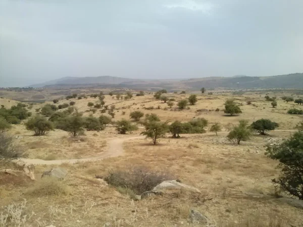
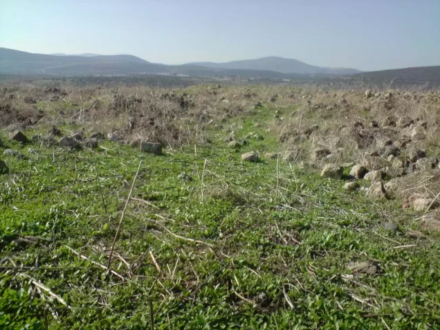
According to the field documentation relied upon by Walid Khalidi, stone rubble covered the entire village site.
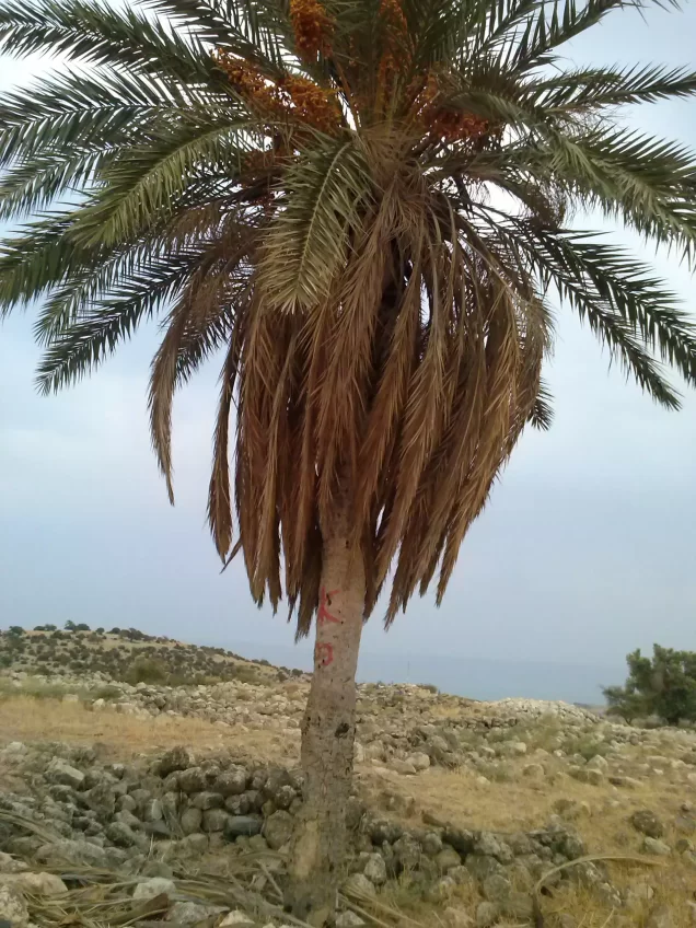
A single palm tree stood near the centre of the site, while an olive grove remained along one edge.
Parts of the surrounding lands were cultivated, while other areas were used for grazing livestock.
A canal belonging to the water-transfer system carrying water from Lake Tiberias to other parts of Palestine passed west of the site.
This description reflects the condition of the site during the period of field documentation relied upon by Walid Khalidi and should not necessarily be interpreted as a comprehensive survey updated to 2026.
Sources
- PalQuest – Interactive Encyclopedia of the Palestine Question: Yaquq.
- PalQuest: Yaquq.
- Palestine Remembered: Yaquq, Tiberias District.
- Walid Khalidi, All That Remains: Yaquq, as reproduced by Palestine Remembered.
- PalQuest: Operation Yiftach – for the broader military context in eastern Galilee.
- Government of Palestine, Census of Palestine 1922, Tiberias Subdistrict table – digital scan.
- Walid Khalidi, All That Remains, entry on Yaquq.
- Government of Palestine, Census of Palestine, 1931.
- Government of Palestine, Department of Statistics, Village Statistics, 1945.
Photo gallery





Photos from the village's people
Photos sent in by visitors and published after review.
Add a photo of this village
Log in to add photos of this village.
Other villages from Tiberias
More from the archive


 Download Our Palestine App
The whole archive in the palm of your hand: depopulated villages, the Nakba, the massacres and Al-Aqsa — free, with no ads to erase the story.
Download Our Palestine App
The whole archive in the palm of your hand: depopulated villages, the Nakba, the massacres and Al-Aqsa — free, with no ads to erase the story.



Comments
No comments yet — be the first to write one.
Add your comment
Name and email are optional. Comments appear after review.