
The depopulated village of Samakh / District of Tiberias

About the depopulated village of Samakh
- District
- Tiberias
- Date Samakh was occupied
- 21 May 1948
- Population in 1948
- 4,014
- Brigade that carried it out
- Golani Brigade
- Who defended the village
- Syrian Army
- Distance from the governorate centre
- 10 km southeast of Tiberias
- Elevation above sea level
- -200 m
- Cause of displacement
- Direct military assault by Zionist forces (Golani Brigade) after the fall of Tiberias had cut the town off from the rest of Palestine
- Extent of destruction
- Samakh was mostly destroyed with the exception the railway station and a water reservoir
- Ethnic cleansing
- On march 3rd 1948, the inhabitants of Samakh were intimidated into fleeing their homes and farms by the Haganah to Nazareth, .
- Settlements built on the land of Samakh before 1948
- Massada and Sha'ar ha-Golan, established in 1937 southeast of the village site, which have since expanded onto village lands
- Settlements built on the built-up area of Samakh after 1948
- Ma'agan, built in 1949 on the village site; Tel Qatzir, built in 1949 on village land
Hover a dot to read the village name, or click to open its card.
Borders of the depopulated village of Samakh
Samakh: A Depopulated Palestinian Town in the Tiberias District
Samakh was a Palestinian town in the Tiberias District, situated at the southernmost shore of Lake Tiberias approximately 10 kilometres southeast of the city of Tiberias, at an average elevation of about 200 metres below sea level. It was the largest village in the Tiberias subdistrict in both population and land area and served as an important transportation and commercial centre. Its population reached 3,460 in the 1944/1945 statistics. Its Palestinian inhabitants were displaced by the end of April 1948 following attacks by the Golani Brigade. The town subsequently became the scene of fighting between Israeli and Syrian forces before the Golani Brigade re-entered it on 21 May 1948.
- Subdistrict
- Tiberias
- Distance from district center
- 10 km southeast of Tiberias
- Average Elevation
- 200 m below sea level
- Population in 1931
- 1,909 – according to PalQuest; other sources give 1,900
- Number of Houses in 1931
- 480
- Population in 1944/1945
- 3,460
- Estimated Population in 1948
- About 4,014 – a later demographic estimate, not an official census
- Total Land Area in 1945
- 18,611 dunams – for a statistical unit that includes the settlements of Massada and Sha'ar ha-Golan, of which 9,265 dunams were Arab-owned
- Attack and Depopulation
- After the fall of Tiberias on 18 April 1948 the Golani Brigade prepared to capture the town, and the History of the Haganah, as cited by Khalidi, states that on 28 April “the police station in Samakh was occupied and the inhabitants evacuated the town”; it was emptied of its inhabitants by the end of the month. A Syrian column assisted by Iraqi forces then wrested it back for a brief period in May, before units of the Golani Brigade re-entered it on the morning of 21 May 1948.
- Final Israeli Control
- 21 May 1948, when units of the Golani Brigade re-entered the town after the Syrian forces withdrew; it had first been occupied on 28 April 1948, and on 24 May the Israeli army claimed that the whole area was in its hands.
- Military Unit
- Golani Brigade; the Yiftach Brigade also attacked the Syrian forces in the town in May 1948 but failed to retake it
- Cause of Depopulation
- Direct military assault by Zionist forces (Golani Brigade) after the fall of Tiberias had cut the town off from the rest of Palestine
- Settlements Documented on Village Lands
- Ma'agan, built in 1949 on the village site; Tel Qatzir, built in 1949 on village land; and Massada and Sha'ar ha-Golan, established in 1937 southeast of the village site, which have since expanded onto village lands
Location
Samakh stood on flat ground in the Jordan Valley at the southernmost end of Lake Tiberias, only a short distance east of the point where the Jordan River leaves the lake.
It was approximately 10 kilometres southeast of Tiberias and had an average elevation of about 200 metres below sea level.
Samakh was the largest village in the Tiberias subdistrict in both land area and population.
Its location made it an important transportation junction linking the regions east and west of the Jordan River and connecting the communities around Lake Tiberias with the Jordan Valley to the south.
The Railway and Transportation
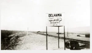
Samakh had an important railway station on the line connecting Haifa with the Hejaz Railway network through the route toward Daraa.
The railway station and Samakh's position near routes leading to Palestine, Transjordan, and Syria contributed to its importance as a transportation, commercial, and service centre.
Lake transportation also connected Samakh with the port of Tiberias.
Samakh Through History
Modern Samakh was established in the early nineteenth century on the remains of a settlement known as Kefar Semah, which had been inhabited during the Roman period.
The principal sources reviewed do not provide sufficient evidence to identify Kefar Semah specifically as a Canaanite town, and this article therefore does not present that claim as established fact.
Swiss traveller Johann Ludwig Burckhardt visited Samakh in 1812 and described approximately thirty to forty mud houses alongside more substantial buildings constructed of black stone.
Later in the nineteenth century, the village had approximately 200 inhabitants who cultivated the surrounding plain.
A linguistic explanation sometimes connects the Arabic name Samakh with the sprouting or growth of crops. This may be treated as a local or linguistic interpretation, but it is not established in the reviewed sources as the documented historical origin of the town's name.
Architecture
Most houses in Samakh were built of adobe and mud, while others were constructed of the black basalt stone common around the Golan and Lake Tiberias area.
As the town expanded and its commercial importance increased, its built environment came to include shops, schools, public buildings, and facilities associated with transportation and trade.
Population
The 1922 census requires an important qualification: Samakh and al-Hamma were counted together, with a combined population of 976. The figure should therefore not be presented as a separate population count for Samakh alone.
The official 1931 census recorded 1,900 inhabitants in Samakh living in 480 houses. They included 1,780 Muslims, 76 Christians, 40 Jews, and 4 Druze.
According to the 1944/1945 statistics, Samakh had 3,460 inhabitants: 3,320 Muslims, 130 Christians, and 10 people belonging to other faiths.
A large proportion of the population belonged to the settled Arab al-Suqur and Arab al-Bashatiwa Bedouin groups.
The claim that approximately 8,500 people inhabited Samakh immediately before the Nakba is not supported by the principal population statistics.
Palestine Remembered gives a later estimate of approximately 4,014 inhabitants in 1948 and estimates the number of refugees and their descendants at 24,648 in 1998.
Population of Samakh
- 1922976Combined census figure for Samakh and al-Hamma
- 19311,900Official census; 480 houses
- 1944/19453,460Government of Palestine statistics
- 1948About 4,014Later estimate
- 199824,648Estimate of refugees and their descendants
Number of Houses
The 1931 census recorded 480 houses in Samakh.
The figure of approximately 1,009 houses for 1948 is a later estimate rather than an official census count.
Local Council
A local council was established in Samakh in 1923 and continued to administer the town during the British Mandate.
The council's expenditures increased from approximately P£310 in 1929 to P£1,111 in 1944, reflecting the growth of the town and its local services.
Education
Samakh had two schools, one for boys and another for girls.
Local educational documentation records a number of teachers and headmasters who worked in Samakh during the Mandate period, including Fallah al-Madi, who served as a teacher and headmaster.
The principal sources reviewed do not provide sufficient evidence to establish that both schools were originally founded during the Ottoman period, and this article therefore does not give that claim as established fact.
Economic Life
The inhabitants of Samakh depended on agriculture and commerce. Grain and bananas were among the principal agricultural products associated with the town and its surrounding area.
Residents also benefited from the railway station, road network, and lake transportation, working in trade, transportation, services, crafts, and other occupations.
Land of Samakh
According to the 1944/1945 statistics, the Samakh statistical unit covered a total of 18,611 dunams.
Arab ownership amounted to 9,265 dunams, Jewish ownership to 8,412 dunams, while 934 dunams were classified as public land.
Importantly, PalQuest notes that these land statistics include Massada and Sha'ar ha-Golan. The ownership and land-use figures should therefore be read within this broader statistical framework.
Land Ownership in the Samakh Statistical Unit, 1944/1945
- Arab ownership9,265 dunums50%
- Jewish ownership8,412 dunums45%
- Public land934 dunums5%
Land Use
The detailed statistics show that some later tables combined public land with Arab land. The following figures preserve the separate Arab, Jewish, and public classifications.
Cereal cultivation covered 16,392 dunams: 8,523 Arab-owned dunams, 7,814 Jewish-owned dunams, and 55 dunams of public land.
A total of 243 dunams of irrigated and plantation land and 264 dunams of citrus and bananas were recorded as Jewish-owned within the statistical unit.
The built-up area covered 352 dunams: 239 Arab-owned, 91 Jewish-owned, and 22 public.
Uncultivable land covered 1,360 dunams: 503 Arab-owned dunams and 857 dunams of public land.
Land Use in the Samakh Statistical Unit in 1944/1945, in Dunams
- Arab
- Jewish
- Public
- Citrus and bananas264 dunums
- Irrigated and plantation land243 dunums
- Cereals16,392 dunums
- Built-up area352 dunums
- Uncultivable land1,360 dunums
The Beginning of Samakh's Depopulation
Some inhabitants began leaving Samakh during the early months of 1948 as military tensions intensified and the town's position on major transportation routes became increasingly vulnerable.
An Israeli intelligence document later published by PalQuest records that women, children, and some wealthier families were among those who left early and that a substantial portion of the population had departed before the final evacuation.
The situation deteriorated further after Zionist forces occupied Tiberias on 18 April 1948, leaving Samakh increasingly isolated.
The Israeli intelligence information is cited here only as transmitted through PalQuest, a Palestinian intermediary source, and not through direct reliance on the Israeli document.
The 28 April 1948 Occupation
Following the fall of Tiberias on 18 April, the Golani Brigade turned its attention toward Samakh and prepared to seize the town.
On 28 April 1948, Zionist forces occupied the Samakh police station, and the Palestinian population had been removed from the town by the end of the month.
Palestinian historian 'Arif al-'Arif wrote that the fall of Tiberias effectively isolated Samakh from the rest of Palestine, leaving only the road toward al-Hamma and from there to Syria and Transjordan.
The principal depopulation of Samakh's Palestinian civilian population therefore occurred at this stage, before the Syrian forces entered the town and before the major fighting of the second half of May.
The Syrian Recapture and the May Fighting
Following the entry of regular Arab armies into Palestine in May 1948, a Syrian column supported by Iraqi forces temporarily regained control of Samakh.
The sources differ on the exact date. One account places the recapture on 18 May, while a contemporary New York Times report placed it two days earlier.
According to a Syrian military source quoted at the time, the attack began at 4:00 a.m. and Samakh fell approximately four hours later.
That same night, the Yiftach Brigade attacked the Syrian defenders in Samakh but failed to retake the town.
On 20 May, Israeli aircraft and heavy artillery struck Syrian positions around Samakh.
The Final Israeli Reoccupation of Samakh
After the Syrian forces withdrew, units of the Golani Brigade re-entered Samakh on the morning of 21 May 1948.
Air attacks against Arab positions in the area continued during the following days, and the Israeli army subsequently announced that the entire area had come under its control.
Two dates should therefore be distinguished: 28 April 1948, when the police station was occupied and Samakh's Palestinian population was evacuated, and 21 May 1948, when Golani units re-entered the town after the brief period of Syrian control.
It is inaccurate to state that the entire Palestinian population was expelled following the fighting of 21 May, since most of Samakh's inhabitants had already left or been removed by the end of April.
Occupation and Depopulation Chronology
- The early months of the war
Beginning of the exodus
Some of Samakh’s inhabitants reportedly left in the early months of the war, as Khalidi relates, but the town was not emptied of its inhabitants until the end of April 1948.
- 28 April 1948
Temporary occupation and depopulation
After the fall of Tiberias on 18 April the Golani Brigade prepared to capture Samakh, and the History of the Haganah, as cited by Khalidi, states only that on this day “the police station in Samakh was occupied and the inhabitants evacuated the town.” PalQuest records that the Haganah attacked and occupied Samakh as part of its offensive in eastern Galilee launched on this day.
- 16 or 18 May 1948
Recapture by Arab forces
According to the Israeli History of the War of Independence as cited by Khalidi, a Syrian column assisted by Iraqi forces wrested control of Samakh on 18 May, while The New York Times reported that it happened two days earlier, the attack beginning at 4:00 a.m. and the town falling four hours later.
- Night of 16 or 18 May 1948
Second attack
That same night the Yiftach Brigade attacked Samakh, inflicting heavy losses on its Syrian defenders, but failed to regain control of the town, as Khalidi relates.
- 20 May 1948
Shelling of the village and its surroundings
The New York Times, as cited by Khalidi, reported that the Israeli air force attacked the Samakh area for the first time since the entry of Arab forces into Palestine; according to the Israeli account, four heavy artillery pieces arrived that day and Israeli occupation forces immediately turned their fire on the Syrian forces quartered near Samakh.
- 21 May 1948
Final occupation
The Syrian forces withdrew, and units of the Golani Brigade re-entered the town on the morning of this day.
- 23–24 May 1948
Air raids on the area and consolidation of control
According to press reports cited by Khalidi, Israeli aircraft attacked Arab installations near Samakh on 23 May for the fourth consecutive night, and the following day the Israeli army claimed that the whole area was in its hands.
- 1949
Settlement on village lands
Ma'agan was built on the village site, and in the same year the nearby settlement of Tel Qatzir was built on village land.
Israeli Settlements on Samakh's Lands
Massada and Sha'ar ha-Golan
Massada and Sha'ar ha-Golan were established southeast of Samakh in 1937, before the Nakba, and later expanded onto village lands.
Samakh itself was therefore not simply renamed “Massada” after 1948.
Ma'agan
Ma'agan was established in 1949 on the Samakh village site.
Tel Qatzir
Tel Qatzir was established in 1949 on Samakh's lands near the former village site.
Deganya Alef and Deganya Bet
Deganya Alef, founded in 1909, and Deganya Bet, founded in 1920, are located near Samakh, but Walid Khalidi and PalQuest state that neither was built on the village's lands.
- 1937Massada
Established southeast of Samakh and later expanded onto village lands
- 1937Sha'ar ha-Golan
Established southeast of Samakh and later expanded onto village lands
- 1949Ma'agan
Established on the Samakh village site
- 1949Tel Qatzir
Established on Samakh's lands
Samakh After the Nakba
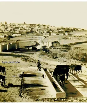
According to the field documentation relied upon by Walid Khalidi, the principal surviving landmarks were the ruins of the railway station and a water reservoir.
A tourist park, gas station, and factory associated with nearby Deganya Alef were established on part of the former village site, while surrounding lands were cultivated.
Palestine Remembered also documents the surviving railway station as one of the principal physical remnants of Samakh.
Khalidi's description reflects the condition of the site during his field documentation and should not necessarily be treated as a comprehensive survey updated to 2026.
Sources
- PalQuest – Interactive Encyclopedia of the Palestine Question: Samakh.
- Palestine Remembered: Samakh, Tiberias District.
- Walid Khalidi, All That Remains, entry on Samakh.
- 'Arif al-'Arif, writings on the Nakba.
- Government of Palestine, censuses of 1922 and 1931.
- Government of Palestine, Department of Statistics, Village Statistics, 1945.
- PalQuest publication of the 30 June 1948 intelligence report on the depopulation of Palestine, used only through the Palestinian intermediary source.
Photo gallery


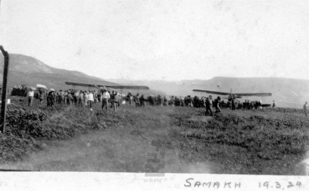


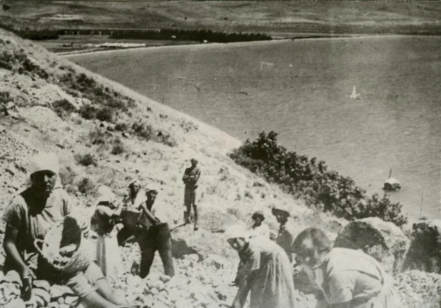


Photos from the village's people
Photos sent in by visitors and published after review.
Add a photo of this village
Log in to add photos of this village.
Other villages from Tiberias
More from the archive


 Download Our Palestine App
The whole archive in the palm of your hand: depopulated villages, the Nakba, the massacres and Al-Aqsa — free, with no ads to erase the story.
Download Our Palestine App
The whole archive in the palm of your hand: depopulated villages, the Nakba, the massacres and Al-Aqsa — free, with no ads to erase the story.



Comments
No comments yet — be the first to write one.
Add your comment
Name and email are optional. Comments appear after review.