
The depopulated village of Qisarya / District of Haifa
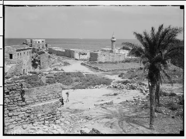
Qisarya
About the depopulated village of Qisarya
- District
- Haifa
- Date Qisarya was occupied
- 15 February 1948
- Population in 1948
- 1,120
- Military operation
- Coastal Clearing
- Brigade that carried it out
- Palmach
- Distance from the governorate centre
- 37 (km) South West of Haifa
- Elevation above sea level
- 25 m
- Cause of displacement
- Expulsion by Zionist troops
- Extent of destruction
- The village had been mostly destroyed by Yitzhak Rabin with the exception of few houses.
- Ethnic cleansing
- Qisarya inhabitants were terrorized out of their homes by the Haganah between January 12th and February 15th 1948
- Settlements built on the land of Qisarya before 1948
- Sedot Yam, established in 1940
- Settlements built on the built-up area of Qisarya after 1948
- Or Akiva, established in 1951, and the Israeli rural locality of Caesarea, officially recognized in 1977
Hover a dot to read the village name, or click to open its card.
Borders of the depopulated village of Qisarya
Qisarya, also known as Caesarea, was a Palestinian coastal village in the Haifa Subdistrict. It stood on the Mediterranean shore, approximately 37 kilometres south of Haifa, and its lands covered 31,786 dunams. The village was occupied by a Palmach unit on 15 February 1948, and most of its inhabitants were displaced. Thirty houses were demolished five days later.
- Subdistrict
- Haifa
- Distance from district center
- 37 km southwest of Haifa
- Average Elevation
- 25 meters above sea level
- Population in 1931
- 706 inhabitants, including Barrat Qisarya
- Number of Houses in 1931
- 143 houses, including Barrat Qisarya
- Population in 1944/1945
- 1,120 inhabitants: 960 Arabs and 160 Jews
- Estimated Population in 1948
- Approximately 1,114 inhabitants, including 160 Jews – a later demographic estimate, not an official census
- Total Land Area in 1945
- 31,786 dunams
- Attack and Depopulation
- A campaign of terror and attacks preceded the final occupation; after the 31 January 1948 ambush of a bus leaving the village, Palmach forces occupied Qisarya on 15 February and the remaining inhabitants were expelled or fled
- Final Israeli Control
- 15 February 1948
- Military Operation
- Coastal Clearing
- Military Unit
- A Palmach unit of the Haganah
- Cause of Depopulation
- Expulsion by Zionist forces amid military assault and intimidation
- Settlements Documented on Village Lands
- Sedot Yam (1940), Or Akiva (1951), and the Israeli rural locality of Caesarea, officially recognized in 1977
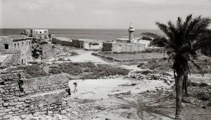
The village followed the shoreline in a north–south direction. Its houses were built of stone bonded with mud or cement, while some Bedouin residents of the surrounding area lived in tents. An elementary school for boys was established around 1884. The inhabitants obtained domestic water from several wells and relied primarily on agriculture. Archaeological excavations have revealed remains from numerous historical periods.
Economic Life in Qisarya
The inhabitants obtained water for domestic use from several wells, and agriculture formed the basis of the village economy. In 1944/45, 18 dunams of Palestinian-owned land were devoted to citrus and bananas, 1,020 dunams to cereal cultivation, and 108 dunams were irrigated or used for orchards. Across the entire statistical unit, including Jewish-owned and public land, 2,193 dunams were used for cereals and 2,319 dunams were classified as cultivable.
Land Ownership in Qisarya
- Palestinian ownership20,959 dunums66%
- Jewish ownership874 dunums3%
- Public land9,953 dunums31%
* One dunam equals approximately 1,000 square metres.
Land Use in Qisarya, 1944/45
- Palestinian ownership (dunams)
- Jewish ownership (dunams)
- Public land (dunams)
- Citrus and bananas18 dunums
- Irrigated land and orchards108 dunums
- Cereal cultivation2,193 dunums
- Cultivable land2,319 dunums
- Built-up area111 dunums
- Uncultivated land29,356 dunums
- Total land area31,786 dunums
* One dunam equals approximately 1,000 square metres.
Population of Qisarya
The 1922 census recorded 346 inhabitants. In 1931, Qisarya and Barrat Qisarya had 706 inhabitants living in 143 houses. The official 1945 statistics recorded 930 Muslims, 30 Christians, and 160 Jews, for a total of 1,120. The Arab population therefore numbered 960. Later demographic estimates give a total of approximately 1,114 in 1948, including 160 Jews, but this was not an official census. The number of Palestinian refugees from Qisarya and their descendants was estimated at 6,839 in 1998.
Population Figures for Qisarya
- 1922346Not stated here
- 1931706Predominantly Arab Muslims and Christians
- 19451,120930 Muslims, 30 Christians, and 160 Jews
- 1948 estimateApproximately 1,114Reported as including 160 Jews
- Estimated Palestinian refugees and descendants, 19986,839Retrospective estimate
* The 1931 figure includes Barrat Qisarya. The 1948 and 1998 figures are later estimates rather than official census totals.
Number of Houses in Qisarya
- 1931143
- 1948 estimate225
* The 1931 figure includes Barrat Qisarya and comes from the official census. The 1948 figure is a later estimate.
Education in Qisarya
A boys' elementary school was established in the village around 1884 during Ottoman rule.
History of Qisarya
The village stood within the ruins of an ancient port city originally known as Strato's Tower. The settlement was established in the late fourth century BCE by Strato, ruler of Sidon, as a Phoenician trading colony. Between 22 and 10 BCE, Herod the Great rebuilt it as a major port and named it Caesarea in honour of his patron, Augustus Caesar. The city later flourished under Roman and Byzantine rule and passed into Arab Muslim hands around 640 CE. Its long history also included Crusader and Mamluk periods before a modern Muslim community was re-established there by Bosnian settlers in 1878.
Archaeological Sites in Qisarya
Qisarya is an archaeological site of exceptional historical importance. Its remains include the ancient harbour, Roman and Byzantine city walls, aqueducts, a theatre, a hippodrome, storage vaults, foundations, architectural fragments, rock-cut features, channels, and a later Crusader fortress. The site preserves material from the Phoenician, Roman, Byzantine, Islamic, and Crusader periods. Large-scale excavations by Italian, American, and Israeli teams have exposed and restored substantial parts of the ancient city for tourism.
Occupation and Depopulation of Qisarya
Israeli historian Benny Morris describes Qisarya as the first Arab community subjected to a pre-planned, organized expulsion by the Haganah in 1948. A Palmach unit captured the village on 15 February. Some residents had already left out of fear of attack; the remaining inhabitants fled or were ordered to leave. When approximately twenty residents insisted on staying, a Palmach unit demolished village houses on 20 February. Thirty houses were destroyed, while six were reportedly spared because the unit lacked sufficient explosives. The demolition formed part of broader Haganah operations to clear Palestinian communities from the coastal plain north of Tel Aviv.
Occupation and Depopulation Chronology
- 31 January 1948
Bus ambush and accelerated flight
Lehi / the Stern Gang ambushed a bus leaving Qisarya on the Haifa road, killing two passengers and injuring others; the attack accelerated the departure of much of the population.
- Early February 1948
Decision to demolish the village
The Haganah General Staff decided to demolish the village houses before the final occupation.
- 15 February 1948
Final occupation and expulsion
A Palmach unit occupied the village. Some residents had already left out of fear of attack; those who remained fled or were ordered to leave after the occupation.
- 20 February 1948
Demolition of houses
A Palmach unit returned and demolished about 30 houses; six were left standing because explosives ran out. The demolition formed part of a wider campaign to clear Palestinian villages from the coastal plain north of Tel Aviv.
Qisarya Today
Sedot Yam had been established on Qisarya's traditional lands in 1940, approximately one kilometre south of the village site. Or Akiva was founded northeast of the village in 1951 and later expanded onto village lands. The Israeli rural locality of Caesarea was officially recognized in 1977.
Most village houses were demolished. The archaeological site was extensively excavated and developed as a tourist area. Published field descriptions report that most of the few surviving houses were converted into restaurants and that the village mosque was repurposed as a bar.
Sources
Photo gallery


Photos from the village's people
Photos sent in by visitors and published after review.
Add a photo of this village
Log in to add photos of this village.
Other villages from Haifa

More from the archive


 Download Our Palestine App
The whole archive in the palm of your hand: depopulated villages, the Nakba, the massacres and Al-Aqsa — free, with no ads to erase the story.
Download Our Palestine App
The whole archive in the palm of your hand: depopulated villages, the Nakba, the massacres and Al-Aqsa — free, with no ads to erase the story.



Comments
No comments yet — be the first to write one.
Add your comment
Name and email are optional. Comments appear after review.