
The depopulated village of Abu Shusha (Haifa) / District of Haifa
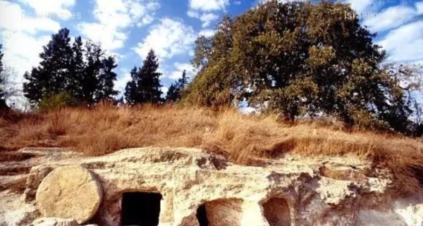
Abu Shusha (Haifa)
About the depopulated village of Abu Shusha (Haifa)
- District
- Haifa
- Date Abu Shusha (Haifa) was occupied
- 12 April 1948
- Population in 1948
- 835
- Military operation
- The Battle of Mishmar ha-'Emeq
- Brigade that carried it out
- Palmach، Alexandroni Brigade، The Carmeli Brigade
- Who defended the village
- Arab Liberation Army
- Distance from the governorate centre
- 26 km southeast of Haifa
- Elevation above sea level
- 125 m
- Cause of displacement
- Direct military assault by Zionist forces (the Haganah), with the inhabitants who had not fled expelled, according to Benny Morris as cited by Khalidi
- Extent of destruction
- The village has been completely destroyed, and only house rubble left behind.
- Ethnic cleansing
- Many of Abu Shusha's inhabitant fled during the battle, and it was completely ethnically cleansed soon after occupation.
- Settlements built on the built-up area of Abu Shusha (Haifa) after 1948
- Khalidi lists no settlement on village lands; the settlement of Mishmar ha-Emeq, founded in 1926, lies less than 1 km south of the village site but is not on village land
Hover a dot to read the village name, or click to open its card.
Borders of the depopulated village of Abu Shusha (Haifa)
Abu Shusha: A Depopulated Palestinian Village in the Haifa District
Abu Shusha was a depopulated Palestinian village in the Haifa District, located approximately 26 kilometers southeast of the city of Haifa on the edge of Marj Ibn Amir, at an average elevation of about 125 meters above sea level. The village extended along both sides of a small, broad wadi and lay west of the archaeological site of Tall Abu Shusha.
- Subdistrict
- Haifa
- Distance from district center
- 26 km southeast of Haifa
- Average Elevation
- 125 m above sea level
- Population in 1931
- 831
- Number of Houses in 1931
- 155
- Population in 1944/1945
- 720
- Estimated Population in 1948
- About 835 – a later demographic estimate, not an official census
- Total Land Area in 1945
- 8,960 dunams
- Attack and Depopulation
- After the failure of the Arab Liberation Army's attack on the settlement of Mishmar ha-Emeq, which began on 4 April 1948, the Haganah launched a counterattack to occupy and destroy the surrounding villages; units from the First Battalion of the Palmach and the Carmeli and Alexandroni Brigades occupied Abu Shusha on the night of 8–9 April 1948, according to the New York Times as cited by Khalidi (10 April according to the PalQuest chronology). The village was then evacuated on the night of 11–12 April and reoccupied on 12 April, and the Haganah blew up many of its houses as a punitive measure; Benny Morris, as cited by Khalidi, states that the inhabitants of these villages who had not fled were expelled.
- Final Israeli Control
- 12 April 1948, when the village was reoccupied after being evacuated on the night of 11–12 April, according to the New York Times as cited by Khalidi. Sources differ on the date of its first occupation: the night of 8–9 April 1948 according to Khalidi, citing the New York Times, and 10 April 1948 according to the PalQuest chronology
- Military Unit
- Units from the First Battalion of the Palmach and from the Haganah's Carmeli and Alexandroni Brigades, according to Khalidi
- Cause of Depopulation
- Direct military assault by Zionist forces (the Haganah), with the inhabitants who had not fled expelled, according to Benny Morris as cited by Khalidi
- Settlements Documented on Village Lands
- Khalidi lists no settlement on village lands; the settlement of Mishmar ha-Emeq, founded in 1926, lies less than 1 km south of the village site but is not on village land
The main Haifa–Jenin road connected the village with both cities and the surrounding area. During the Nakba and the occupation of Palestine in 1948, Abu Shusha was subjected to a series of attacks in April before being occupied by Zionist forces during the Battle of Mishmar ha-'Emeq. Its Palestinian inhabitants were displaced and the village was destroyed.
Location of Abu Shusha
- Abu Shusha was located approximately 26 kilometers southeast of Haifa.
- Its average elevation was about 125 meters above sea level.
- The village extended along both sides of a small, broad wadi on the edge of Marj Ibn Amir.
- It lay west of the archaeological site of Tall Abu Shusha.
- The main Haifa–Jenin road connected it with both cities and neighboring villages.
The Built Environment of Abu Shusha
In the late nineteenth century, Abu Shusha was described as a small settlement on the edge of the plain that obtained its water from a spring to the west. Most of its houses were constructed of stone; some had roofs made of mud and straw, while others were built of concrete.
The inhabitants were Muslims, and the village had a mosque and an elementary school. Water was available from several sources, including two wadis and a spring used for domestic needs.
Land Ownership in Abu Shusha
The total land area recorded for Abu Shusha in the 1944/1945 statistics was 8,960 dunums. The Arabic Palestine Remembered table uses the categories “Palestinian,” “Transferred to Zionists,” and “Masha'.” These terms are preserved below to reflect the terminology of that source.
The Government of Palestine statistics, as reproduced by PalQuest, record 5,883 dunums as Arab-owned and 3,077 dunums as public land, with no Jewish-owned land recorded within the village lands.
Land Ownership in Abu Shusha, 1944/1945, Using the Terminology of Palestine Remembered
- Palestinian5,883 dunums66%
- Transferred to Zionists0 dunums0%
- Masha' / Communal3,077 dunums34%
Land Use in Abu Shusha in 1944/1945
A total of 5,870 dunums was cultivated or classified as cultivable land, including 4,939 dunums devoted to cereals and 931 dunums irrigated or used for plantations. Non-cultivable land totaled 3,090 dunums, consisting of 13 dunums of Arab land and 3,077 dunums of public land.
Land Use in Abu Shusha According to the 1944/1945 Statistics
- Arab
- Public
- Cereals4,939 dunums
- Plantations and Irrigable Land931 dunums
- Non-Cultivable Land3,090 dunums
The sources differ regarding the amount of land planted with olive trees. Walid Khalidi's narrative in All That Remains states that approximately 600 dunums were planted with olive trees, while the Palestine Remembered table, attributed to the 1945 Village Statistics, gives a figure of 130 dunums. The discrepancy is therefore preserved rather than treating either figure as conclusively representing the same statistical category.
Economic Life in Abu Shusha
The economy of Abu Shusha depended on agriculture and animal husbandry, with cereals among the principal crops. The inhabitants also cultivated vegetables, tobacco, fruit trees, and olives.
Agriculture included both rainfed and irrigated cultivation, with irrigation being particularly important for vegetables. A grain mill bearing the village's name stood on the northeastern edge of the site.
Population of Abu Shusha
The 1931 census recorded 831 inhabitants in Abu Shusha living in 155 houses. The Government of Palestine's 1944/1945 statistics recorded a population of 720, consisting of Arab Muslims.
The figure of 835 inhabitants for 1948 and the estimate of 5,129 refugees for 1998 published by Palestine Remembered are later estimates and are not official Government of Palestine censuses.
Population of Abu Shusha
- 1931831Official census under the British Mandate
- 1944/1945720Government of Palestine statistics
- 1948835Estimate published by Palestine Remembered
- 19985,129Estimated refugee population published by Palestine Remembered
Number of Houses in Abu Shusha
The 1931 census recorded 155 houses in Abu Shusha. Palestine Remembered gives the same figure for 1948, but this does not represent a separate official Government of Palestine census conducted in that year.
Number of Houses in Abu Shusha
- 1931155Official census
- 1948155Figure published by Palestine Remembered; not an official 1948 census
Facilities and Education in Abu Shusha
Abu Shusha had a mosque and an elementary school, while its grain mill was among the village's economic facilities. Palestinian sources also state that some children attended the school in nearby Abu Zurayq.
Archaeological Remains in Abu Shusha
The nearby Tall Abu Shusha was a large and ancient archaeological site, and remains at both the tell and the village site indicate a long history of settlement. Some researchers have suggested that the tell may have been the site of the Roman town of Gaba Hippeon.
Sources refer to a mound of ruins, a vaulted chamber, mosaic flooring, architectural fragments, and rock-cut tombs.
The Raid on Abu Shusha on 1 April 1948
In early April 1948, before the village's final occupation, units of the Second Battalion of the Giv'ati Brigade raided Abu Shusha.
Walid Khalidi, citing the History of the Haganah, states that the raid followed the killing of a guard from a nearby Jewish settlement on land belonging to the village, after which orders were issued for what that source described as a “retaliatory operation.”
After midnight on 1 April, the attacking force destroyed one house and the village well. A firefight subsequently took place with local Palestinian defenders, during which a soldier from the attacking force was fatally wounded. The cited account does not state the number of Palestinian casualties.
This raid did not constitute the final occupation of Abu Shusha and should therefore be distinguished from the later attack during the Battle of Mishmar ha-'Emeq.
The Occupation of Abu Shusha and the Displacement of Its Inhabitants During the Nakba
The actual occupation of Abu Shusha was connected with the Battle of Mishmar ha-'Emeq, which began on 4 April 1948 when the Arab Liberation Army launched an attack on the Jewish settlement of Mishmar ha-'Emeq.
After the Arab Liberation Army's offensive stalled, a British-mediated truce was proposed. The Haganah leadership rejected the proposal and instead launched a counteroffensive aimed at occupying the surrounding Palestinian villages.
According to Walid Khalidi, citing reports in The New York Times, Haganah forces broke through on the night of 8–9 April 1948 and occupied Abu Shusha, Abu Zurayq, and al-Naghnaghiyya. The force consisted of units from the First Battalion of the Palmach and the Carmeli and Alexandroni Brigades.
Palestine Remembered gives 9 April 1948 as the occupation date of Abu Shusha and likewise identifies the attacking force as a combination of Palmach, Carmeli, and Alexandroni units.
Control of the village nevertheless passed through further stages. Khalidi records that a New York Times report stated that Abu Shusha was evacuated on the night of 11–12 April and reoccupied on 12 April. The Haganah also demolished a number of village houses.
Walid Khalidi further cites Israeli historian Benny Morris as stating that inhabitants of the villages surrounding Mishmar ha-'Emeq who had not fled were expelled and that the villages were systematically destroyed. This information is included because it is cited by the Palestinian source Khalidi/PalQuest, rather than through independent reliance on an Israeli source.
These operations ultimately resulted in the displacement of Abu Shusha's Palestinian inhabitants during the Nakba and the destruction of the village. Following its occupation, Zionist forces gained control of the main Jenin–Haifa road.
Occupation and Depopulation Chronology
- 4 April 1948
Beginning of the battle of Mishmar ha-Emeq
The Arab Liberation Army launched an offensive aimed at occupying the kibbutz of Mishmar ha-Emeq, but failed in its objective. After the attack stalled, the Haganah rejected a British-mediated truce offer, and its commanders decided instead on an extensive counterattack to occupy and destroy the surrounding villages, according to Khalidi.
- Night of 8–9 April 1948; or 10 April 1948
First occupation of the village
The New York Times, as cited by Khalidi, reported that Haganah units besieged in Mishmar ha-Emeq broke out on the night of 8–9 April and occupied Abu Shusha, Abu Zurayq and al-Naghnaghiyya; the units belonged to the First Battalion of the Palmach and to the Carmeli and Alexandroni Brigades. The PalQuest chronology, however, dates the Haganah's occupation of Abu Shusha to 10 April 1948.
- Night of 11–12 April 1948
Evacuation of the village
The New York Times, as cited by Khalidi, reported that Abu Shusha was evacuated again on the night of 11–12 April; the source does not say who evacuated it.
- 12 April 1948
Final occupation
The village was reoccupied on 12 April, according to the New York Times as cited by Khalidi, and having seized it, Zionist forces gained control of the Jenin–Haifa road. By 12 April, Palmach forces had occupied five villages around Mishmar ha-Emeq.
- April 1948
Depopulation and destruction of the village
The Haganah blew up many houses in Abu Shusha as a punitive measure, according to the New York Times correspondent as cited by Khalidi. Benny Morris, as cited by Khalidi, states that the inhabitants of the villages captured in the battle of Mishmar ha-Emeq who had not fled were expelled, and that each village was systematically destroyed on the night it was occupied.
Settlements on the Lands of Abu Shusha
According to Walid Khalidi and PalQuest, no Israeli settlement was established on the lands of Abu Shusha itself.
Mishmar ha-'Emeq, founded in 1926, is located less than one kilometer south of the village site, but it was not established on Abu Shusha's lands.
The Site of Abu Shusha After the Nakba
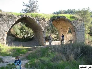
According to Walid Khalidi's field description, little remained of Abu Shusha except the rubble of its houses, overgrown with cactuses. The village grain mill had disappeared.
Olive trees continued to grow on the hills surrounding the site within a fenced area used for grazing, while the neighboring lands of Marj Ibn Amir were cultivated with various crops.
This description is based on fieldwork conducted for All That Remains and should not necessarily be treated as a field survey updated to the present day.
Sources
- Institute for Palestine StudiesPalQuest – Interactive Encyclopedia of the Palestine Question: Abu Shusha, Haifa
- Institute for Palestine StudiesInstitute for Palestine Studies: Walid Khalidi, All That Remains
- Palestine RememberedPalestine Remembered: Abu Shusha – Haifa District
- Palestine RememberedGovernment of Palestine: Census of Palestine, 1931
Photo gallery


Photos from the village's people
Photos sent in by visitors and published after review.
Add a photo of this village
Log in to add photos of this village.
Other villages from Haifa
More from the archive



 Download Our Palestine App
The whole archive in the palm of your hand: depopulated villages, the Nakba, the massacres and Al-Aqsa — free, with no ads to erase the story.
Download Our Palestine App
The whole archive in the palm of your hand: depopulated villages, the Nakba, the massacres and Al-Aqsa — free, with no ads to erase the story.



Comments
No comments yet — be the first to write one.
Add your comment
Name and email are optional. Comments appear after review.