
Palestine’s Place Names: Memory, Maps, and the Politics of Renaming
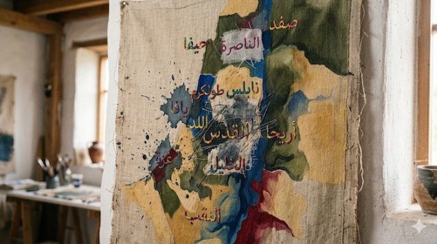
Palestine’s Place Names: Memory, Maps, and the Politics of Renaming
Palestine’s Place Names: Memory, Maps, and the Politics of Renaming
How do the names of villages, mountains, and valleys become part of the struggle over places and the stories told about them?
When Palestinians name their village, they evoke more than a point on a map: the family home, the path to the fields, the spring that supplied water, and the cemetery where their ancestors rest. A name connects geography to everyday life and preserves part of a community’s history even when its buildings are demolished or its residents displaced. This is why studying place names matters: it helps us understand the relationship between control over land and control over how that land is represented in public memory.
Published studies have examined the renaming of Palestinian sites and changes in their representation on maps and in tourism. Among them is Noga Kadman’s Erased from Space and Consciousness, which investigates the history of 418 depopulated villages, addressing official names, maps, and the ways village sites are presented to the public. This work provides a research basis for studying the obscuring of Palestinian presence, while leaving each individual name and location subject to verification. [1]
1 — Why Are Names Part of Identity?
A geographical name can be read as a linguistic and social trace: it may refer to the shape of the terrain, a plant, a water source, a family, or a shrine. Its repeated use in speech and documents makes it a link between generations. Excluding a name therefore has consequences beyond language: it may make it harder for readers or visitors to recognize the community that lived at a site or connect what they see today with older documents.
In this context, a map calls for critical reading: who assigned its names, in which period, and which names did they choose to display? Establishing an official name gives it a presence in education, administration, and tourist information. Analytically, this practice can become a means of reinforcing a narrative about a place when it excludes residents’ names and history.
2 — From Changing Names to Naming Policy
Place names change for many reasons, including shifts in languages, administrations, and settlement patterns. Studying the Palestinian case, however, requires attention to context: did the change occur as part of parallel usage in another language, after residents were displaced, alongside the establishment of a new community, or through an official decision that redrew the map? These circumstances have different meanings, even when they sometimes converge at the same location.
An account published by the Israel State Archives documents the establishment of a geographical names commission in 1949 under the Prime Minister’s Office, with the purpose of assigning Hebrew names to geographical features. This record helps establish the institutional dimension of naming, while studying its social impact requires consulting maps, records, residents’ testimonies, and specialist research. [2]
It is important to distinguish evidence of a naming policy from evidence about each individual case. Establishing that a site was renamed requires identifying its location, previous name, subsequent name, the authority that adopted it, and, where possible, the date of adoption. The more complete these elements are, the more rigorously claims about the erasure or reshaping of memory can be examined.
3 — How Should Relationships Between Names Be Classified?
A two-column list of Arabic and Hebrew names does not, by itself, establish direct replacement. Research can therefore be organized using the following categories:
| Type of relationship | What does it mean? | What is needed for verification? |
|---|---|---|
| Official renaming | Adopting a new name for the same site in an administrative or cartographic context. | A naming decision or dated maps identifying the same location. |
| Translation of meaning | Using a name in another language with a meaning close to that of the Arabic name. | Examining meaning and context; translation alone does not establish erasure. |
| Phonetic adaptation | Adjusting a name’s pronunciation or spelling to suit another language. | A sequence of historical forms, rather than similarity between words alone. |
| Parallel historical name | More than one name for a place across different periods or traditions. | Establishing the period of each name and the boundaries of the site it denotes. |
| New community on the land of an earlier site | Establishing a settlement or town on village land or nearby. | Distinguishing the village’s lands, the location of its buildings, and the boundaries of the new community. |
| Tourist or archaeological name | Presenting a site within an existing neighborhood under a historical label or tourism project. | Comparing the project’s extent with the neighborhood and studying the narrative it presents. |
4 — Documented Examples Requiring a Clear Description of the Relationship
Yahya Abd al-Ra’uf Jabr’s study, published by BADIL, presents several correspondences between names. The following examples come from that study; their classification here is an organizational interpretation, rather than independent proof of the history of each naming decision. [3]
| Arabic name | Corresponding name in the source | Relationship / verification note |
|---|---|---|
| Bab al-Wad | Sha’ar HaGai | Translation of meaning. |
| Jabal al-Zaytun (Mount of Olives) | Har HaZeitim | Translation of meaning. |
| Jabal al-Jarmaq | Har Meron | Corresponding name; its adoption date requires further documentation. |
| Jabal Faqqu’a | Har HaGilboa | Corresponding name with a historical reference. |
| Tall Abu Hurayra, in the northwestern Naqab/Negev | Tel Haror | The source describes the relationship as a distortion of the name. |
| Tall al-Malha, in the Baysan/Beit She’an Valley | Tel Ishtori | Should not be confused with Tall al-Mulayha. |
| Tall al-Mulayha, near Bir al-Sab’/Beersheba | Tel Malhata | The source describes the relationship as a distortion of the name. |
These examples illustrate the importance of providing a geographical description alongside a name. Names such as “al-Malha” and “al-Mulayha” recur in different regions, making the omission of location a potential source of confusion. Specialist research should also include the original Hebrew spelling to avoid ambiguity caused by rendering sounds in Arabic.
5 — Religious and Historical Names: How Should They Be Approached?
Studying names with religious references requires separating three questions: does the name appear in an ancient text, can the location it denotes be identified, and how has the name been used in modern naming? A name’s appearance in a text does not, by itself, establish its location on a map. Nor does the existence of an ancient name demonstrate that its contemporary use began after 1948.
It is therefore necessary to avoid generalizations that all identifications between ancient texts and present-day sites are correct, or that all are fabricated. Each case should be examined using available evidence: inscriptions, archaeological remains, historical geography, and successive forms of names. This is a methodological precaution in documentation, rather than a predetermined judgment about archaeological findings.
Politically, establishing one historical layer at a site does not reduce the site’s entire history to that layer or erase the presence and memory of its contemporary inhabitants. The use of history to exclude Palestinians can be criticized while acknowledging the many periods and cultures through which the country has passed. An accurate Palestinian narrative need not deny others’ histories; it can instead reject the obscuring of Palestinian history and rights.
6 — Jerusalem: When the Erasure of a Place Changes Its Representation
The Moroccan Quarter offers a clear example of how the obscuring of memory can begin with the destruction of the place itself. According to the historical account published by Jerusalem Story, the quarter was demolished in June 1967 to create the plaza beside the al-Buraq/Western Wall. Approximately 650 people who lived in 135 homes were displaced, and two mosques were also demolished. The account draws on references and testimonies, including Ruhi al-Khatib’s testimony before the UN Security Council. [4]
This case raises a question that goes beyond names on signs: how can visitors to the plaza today know that a residential neighborhood once stood there? Displaying photographs, maps, residents’ names, and the history of the quarter’s religious endowments restores part of the site’s social meaning. An apparently empty space in today’s landscape does not mean that it was empty in the past.
Jerusalem’s neighborhoods require particular care when compiling tables: one name may refer to a street, another to a neighborhood, and a third to a settlement project within that neighborhood. Placing them in a single row without explanation implies that their boundaries coincide, turning a difference in geographical extent into a historical error.
7 — Ras al-Amud and Wadi Hilweh: Two Different Cases
Ras al-Amud: A Settlement Within a Palestinian Neighborhood
An article in the Arabic Journal of Palestine Studies describes Ma’ale HaZeitim as a settlement established within Ras al-Amud. It should therefore not be presented as the alternative Hebrew name for the entire neighborhood. The more accurate wording is: “Ma’ale HaZeitim: a settlement within the Palestinian neighborhood of Ras al-Amud.” This description preserves the distinction between the existing neighborhood and the settlement project within it. [5]
Wadi Hilweh: An Existing Neighborhood and an Archaeological Site Presented as the “City of David”
Jerusalem Story identifies Elad as a settler association operating around sites in Jerusalem, including the “City of David” site in the Wadi Hilweh neighborhood of Silwan. This wording clarifies that the tourist and archaeological name is associated with a site within a Palestinian neighborhood; its extent should not be assumed to encompass all of Silwan. [6]
In a report published in 2013, Emek Shaveh, an organization specializing in the relationship between archaeology and conflict, criticizes the narrative presented on tours, arguing that it emphasizes particular periods while marginalizing others and contemporary residents. This should be presented as the organization’s assessment, while retaining the distinction between scientific excavation findings and their use in tourist and political narratives. [7]
From a critical perspective, the question becomes: do visitors encounter the neighborhood’s entire history, or a selected layer of it? Do they learn about families, streets, and everyday life around the site? Studying tourist presentation involves examining what is included, what is omitted, and how the past is connected to the present.
8 — Numbers: Why Were Unverified Statistics Removed?
This version does not adopt the figures “more than 7,000 names” and “2,780 sites,” or attribute them to a 1992 study, because the original study’s bibliographic details and counting methodology were not established in the review underlying this version. Declining to use a figure does not prove it wrong; it means that its use requires a source readers can consult.
Before publishing any statistic, several points must be clarified: does it count names or sites, what are its geographical and chronological limits, and does it include translations, parallel names, and new settlements alongside official renaming? A single site may have several names, making the “number of names” substantially different from the “number of places.”
The figure of 418 in Kadman’s book refers to the villages covered by the book, rather than a comprehensive count of names changed in Palestine. [1] Respecting this distinction prevents the article from turning the findings of a particular study into a broader conclusion than they support.
9 — How Can Palestine’s Place Names Be Preserved and Documented?
Interest in names can be developed into a practical documentation project. A proposed record for each site would include its Arabic name and local variants, coordinates, type of geographical feature, maps on which it appears and their dates, its current name, the relationship between the names, the source of each piece of information, and any remaining uncertainty or disagreement.
Documents can be supplemented with residents’ testimonies, recording the narrator’s name, interview date, and basis of knowledge. Testimony preserves details that maps may omit, but should preferably be compared with other records when land boundaries or the date of an official decision are involved. Photographing signs, buildings, and springs, and linking the images to their locations and dates, is also useful.
In digital publishing, multiple names can be displayed together with the source of each, rather than concealing one of them. This approach allows readers to trace changes themselves and gives Palestinian names a searchable presence that can be used in education, guiding, and family memory.
The Struggle Over Memory Begins With Getting the Name Right
Defending Palestine’s place names means defending its people’s ability to tell their history and describe their connection to the land. That narrative becomes stronger when evocative language is accompanied by clear documentation, and when it distinguishes renaming from translation, a neighborhood from a settlement, and an archaeological site from the community living around it.
Preserving a place name begins with identifying its location, gathering its story, and documenting its sources, so that its people remain present in both the map and memory.
References
- Noga Kadman, Erased from Space and Consciousness, Indiana University Press, 2015. Publisher’s book page and summary. The available summary and table of contents were consulted, rather than the full text.
- Israel State Archives, A thriving community, an archival reference to the establishment of a geographical names commission in 1949. Link. Information visible in the indexed search result was used; the full page could not be opened during the review.
- Yahya Abd al-Ra’uf Jabr, “Palestinian Geographical Names Between Erasure and Distortion” [Arabic title translated], BADIL, Haq al-Awda. Article. A source for the examples; individual decisions and dates require independent documentation.
- Jerusalem Story, The Destruction of Jerusalem’s Moroccan Quarter. Article and references.
- Arabic Journal of Palestine Studies (Majallat al-Dirasat al-Filastiniyya), no. 134, Spring 2023, an article on Jerusalem’s neighborhoods, p. 138 in the file covering pp. 121–144. File. The indexed excerpt concerning Ras al-Amud was used; the full file could not be opened during the review.
- Jerusalem Story, Elad Association. Entry.
- Emek Shaveh, Elad’s Settlement in Silwan, September 10, 2013. Report. Used to document the organization’s critical assessment of site management and tourist presentation.
More from the archive
 Download Our Palestine App
The whole archive in the palm of your hand: depopulated villages, the Nakba, the massacres and Al-Aqsa — free, with no ads to erase the story.
Download Our Palestine App
The whole archive in the palm of your hand: depopulated villages, the Nakba, the massacres and Al-Aqsa — free, with no ads to erase the story.



Comments
No comments yet — be the first to write one.
Add your comment
Name and email are optional. Comments appear after review.