
The depopulated village of Dayr al-Qasi / District of Akka (Acre)
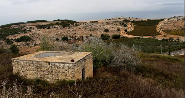
Dayr al-Qasi
About the depopulated village of Dayr al-Qasi
- District
- Akka (Acre)
- Date Dayr al-Qasi was occupied
- 30 October 1948
- Population in 1948
- 1,320
- Military operation
- Operation Hiram
- Who defended the village
- Local militia & Arab Liberation Army
- Distance from the governorate centre
- 26 (km) Northeast of Acre
- Elevation above sea level
- 675
- Cause of displacement
- Military assault by Zionist troops
- Extent of destruction
- Dayr al-Qasi was mostly destroyed with the exception of few houses currently being used by Israeli Jewish settlers.
- Ethnic cleansing
- Dayr al-Qasi was mostly ethnically cleansed soon after occupation, and on May 27th, 1949 the "Jewish state" ethnically cleansed all remaining residence to Lebanon.
- Settlements built on the built-up area of Dayr al-Qasi after 1948
- Netu'a, Mattat, and Abirim; part of the village site is occupied by Elkosh
- Refugees' migration routes
- Dayr al-Qasi refugees were pushed northward to a route leading to Rumaysh in Lebanon, which was known then to the Israelis by al-Qawuqji Route.
Hover a dot to read the village name, or click to open its card.
Borders of the depopulated village of Dayr al-Qasi
Dayr al-Qasi – Depopulated Palestinian Village of the Acre District
Dayr al-Qasi was a depopulated Palestinian village in the Acre District. It stood on a rocky hill in the central part of western Upper Galilee, approximately 26 kilometers northeast of Acre and about five kilometers south of the Lebanese border.
The village had an average elevation of approximately 675 meters above sea level. A road paved during the Second World War connected it with Fassuta to the north and Tarshiha to the southwest.
Israeli occupation forces took control of Dayr al-Qasi on 30 October 1948, probably after the fall of neighboring Tarshiha, during Operation Hiram. The occupation did not immediately remove the entire Palestinian population. Some residents remained in the area afterward, and the village was not completely emptied until the following months.
| Field | Information |
|---|---|
| District | Acre in the late Mandate period; Dayr al-Qasi was listed under Safad District in the 1922 and 1931 censuses. |
| Historical Administrative Location | Western Upper Galilee; listed under Safad District in the 1922 and 1931 censuses and under Acre District in later sources and statistics. |
| Distance from District Center | Approximately 26 km from Acre. |
| Direction | Northeast of Acre. |
| Average Elevation | Approximately 675 meters above sea level. |
| Population in 1922 | 663 inhabitants according to the official census; all were Muslims. |
| Population in 1931 | 865 inhabitants according to the official census: 450 males and 415 females, all Muslims. |
| Houses in 1931 | 169 inhabited houses according to the official census. |
| Arab Population in 1944/1945 | No separate figure is available for Dayr al-Qasi alone. The statistical unit comprising Dayr al-Qasi, Fassuta, and al-Mansura had a total Arab population of 2,300. |
| Jewish Population within the Statistical Unit in 1944/1945 | 0. |
| Total Population of the Statistical Unit in 1944/1945 | 2,300 inhabitants; the figure includes Dayr al-Qasi, Fassuta, and al-Mansura and should not be attributed to Dayr al-Qasi alone. |
| Estimated Population in 1948 | No separate figure is available for Dayr al-Qasi. Salman Abu Sitta records 2,668 inhabitants with a note indicating that the figure includes Fassuta and al-Mansura. |
| Total Land Area | 34,011 dunums for the combined statistical unit of Dayr al-Qasi, Fassuta, and al-Mansura; this is not a separate land-area figure for Dayr al-Qasi alone. |
| Land Ownership | Palestinian: 26,619 dunums; Transferred to Zionists: 0 dunums; Public/Common: 7,392 dunums. These figures apply to the combined statistical unit of Dayr al-Qasi, Fassuta, and al-Mansura. |
| Date of Occupation | 30 October 1948 according to Walid Khalidi and PalQuest; Salman Abu Sitta records 29 October 1948 as the depopulation date. |
| Final Depopulation Date | Not conclusively established. Some residents remained after the occupation, and residents were still present in the area in December 1948. The exact date on which the remaining villagers were expelled is not specified. |
| Military Operation | Operation Hiram, 28–31 October 1948. |
| Military Unit | Not independently documented at the village level. The 7th, Carmeli, Golani, and Oded brigades participated in Operation Hiram more broadly. |
| Cause of Depopulation | Military attack and occupation during Operation Hiram, followed by the later displacement and expulsion of residents who remained in the village; depopulation was not completed on the day of occupation. |
| Extent of Destruction | Extensive destruction, with no documented numerical percentage. Several stone houses and the school building remained, while ruins of destroyed houses are scattered across the site. |
| Settlements Established before 1948 on Village Land | No settlement established before 1948 on Dayr al-Qasi land was confirmed in the sources used. |
| Settlements Established after 1948 on Village Land | Elkosh – 1949; Netu'a – 1966; Mattat – 1979; Abirim – 1980. |
Location and Geography
Dayr al-Qasi stood on a rocky hill in western Upper Galilee, surrounded by cultivated land and fig and olive trees.
It lay approximately 26 kilometers northeast of Acre and only about five kilometers south of the Lebanese border, at an average elevation of around 675 meters above sea level.
The paved road connected the village with Fassuta to the north and Tarshiha to the southwest. Dayr al-Qasi also had close agricultural, cadastral, and water-resource ties with Fassuta and neighboring al-Mansura.
Supporting Palestinian local documentation places al-Mansura to the northeast, Fassuta to the northwest, Suhmata to the southwest, and Hurfaysh to the east.
Name
The first element of the name, dayr, meaning monastery, suggests the possible presence of a monastery or a Christian community at an earlier period. The name alone, however, does not establish the character or date of such a monastery.
Palestinian local documentation also reports an older form of the name, Dayr al-Waqasiyya, in documents preceding the modern form Dayr al-Qasi.
Ottoman Period
In 1596, Dayr al-Qasi belonged to the nahiya of Jira in the liwa' of Safad. Walid Khalidi gives an estimated population of approximately 132.
The villagers paid taxes on wheat, barley, goats, beehives, and other agricultural products.
Supporting Palestinian local documentation interprets the Ottoman tax register differently, identifying seventy-seven taxable household units, including fifteen bachelors, and deriving a larger population estimate. Because this relies on a different method of converting fiscal households into population, it is not treated as a modern census equivalent to Khalidi's estimate.
In the late nineteenth century, Dayr al-Qasi was described as a village on a ridge surrounded by fig and olive trees and cultivated land, with an estimated population of approximately 200 in that particular survey.
Built Environment
A paved road divided Dayr al-Qasi into two principal quarters, eastern and western. The eastern quarter stood at a higher elevation than the western one.
Most houses were constructed of adobe brick, although some newer buildings were made of stone.
The village had two mosques, one in each quarter, as well as two shrines: one dedicated to Shaykh Jawhar and another to Abu Halyun. A zawiya belonging to the al-Shadhiliyya Sufi order was also located in the village.
Population and Houses
Official village-specific census figures must be distinguished from later statistical entries that grouped Dayr al-Qasi with neighboring communities.
| Year | Population | Note |
|---|---|---|
| 1596 | About 132 | Historical estimate cited by Walid Khalidi from Ottoman-era records |
| 1922 | 663 | Official census; all inhabitants were Muslims |
| 1931 | 865 | Official census; all inhabitants were Muslims, living in 169 houses |
| 1945 | No securely isolated figure for Dayr al-Qasi alone | The official population table groups Dayr al-Qasi with al-Mansura, while PalQuest aggregates Dayr al-Qasi, al-Mansura, and Fassuta to a total of 2,300 |
The official 1931 census recorded 865 inhabitants in 169 houses.
The 1945 figures require particular care. The official population table lists “Deir el Qasi and El Mansura” together at 1,250 inhabitants, while Fassuta is listed separately at 1,050. PalQuest presents the combined total of all three villages as 2,300.
The figure of 2,300 must therefore not be presented as the population of Dayr al-Qasi alone. Later refugee and 1948 population estimates that mechanically treat 2,300 as a village-specific baseline are likewise not used here as reliable independent figures.
Education
An elementary boys' school was established in Dayr al-Qasi during the British Mandate.
Khalidi's principal account does not provide a securely documented mid-1940s enrollment figure, so no unsupported pupil total is included.
Supporting Palestinian community documentation states that formal schooling developed gradually in the early 1930s and that by 1943 a school building provided education through the sixth grade. Children from neighboring Hurfaysh reportedly also attended.
The same local source reports the opening of a private girls' school in 1947 with twenty-two pupils on the eve of the Nakba. These details are presented as supporting community documentation.
Water Resources
The villagers obtained domestic water from the springs of Fassuta and al-Mansura and from a large pool inside Dayr al-Qasi that collected rainwater.
Supporting Palestinian local documentation also names wadis and springs used in agriculture, including Wadi al-Habis, Wadi al-Hammam, Wadi al-Qarn, and 'Ayn al-Najjara. These names are treated as local supporting details rather than replacements for the principal historical description.
Economic Life
Most inhabitants depended on agriculture, cultivating grain, legumes, vegetables, olives, and other fruit trees.
Some villagers joined the civil service in urban centers, while others worked at British military bases during the Mandate.
The village lands were registered together with those of Fassuta and al-Mansura. The 1944/45 land statistics therefore apply to the three-village unit and do not permit a reliable separation of Dayr al-Qasi's share.
Land Ownership, 1944/45
The following figures apply jointly to Dayr al-Qasi, Fassuta, and al-Mansura.
- Arab26,619 dunums78%
- Jewish0 dunums0%
- Public7,392 dunums22%
The table balances exactly: 26,619 Arab dunams plus 7,392 Public dunams equal a total of 34,011 dunams.
Using Palestine Remembered's simplified terminology, the same figures appear as 26,619 dunams “Palestinian,” 0 dunams “Transferred to Zionists,” and 7,392 dunams “Communal/Public.” The source's terminology should be preserved rather than mixed with the official Government of Palestine categories.
Land Use, 1944/45
These figures also apply jointly to Dayr al-Qasi, Fassuta, and al-Mansura.
- Arab
- Public
- Cereals6,475 dunums
- Plantations and irrigable land1,617 dunums
- Total cultivable/cultivated land8,092 dunums
- Non-cultivable land25,672 dunums
- Built-up land247 dunums
- Total non-cultivable and built-up25,919 dunums
The official table balances exactly: 8,092 dunams of cultivated or cultivable land plus 25,919 dunams of built-up and non-cultivable land equal the total 34,011 dunams.
Palestine Remembered separately gives approximately 900 dunams of olive groves. This is a crop-specific subset of the agricultural land and should not be added again to the land-use total.
Archaeological Remains
Walid Khalidi reports that villagers recalled the discovery, during the Ottoman and British Mandate periods, of objects attributed to Canaanite, ancient Israelite, and Roman periods. Most of these artifacts were subsequently lost.
Because this information was transmitted through village residents rather than a published modern archaeological survey, it is retained in that cautious form rather than treated as a complete archaeological chronology of the site.
Operation Hiram
Operation Hiram began on 28 October and ended on 31 October 1948. It was a large Israeli offensive intended to conquer the remaining Arab-held areas of Upper Galilee and the pocket extending along the Lebanese frontier.
Several Israeli brigades participated in the operation as a whole. However, the village-specific Dayr al-Qasi account does not identify a particular brigade as the force that physically entered the village. No brigade is therefore assigned at village level without direct evidence.
Occupation of Dayr al-Qasi
Dayr al-Qasi came under Israeli occupation on 30 October 1948, probably after the fall of neighboring Tarshiha.
The capture of both villages formed part of Operation Hiram.
Following the attack on Tarshiha, some defenders withdrew north along a hidden road that passed through Dayr al-Qasi toward Rumaysh in Lebanon. This route served as a major Arab Liberation Army supply line in Upper Galilee and was referred to by the Haganah as the “Qawuqji Road.”
Military Unit
The village was occupied by Israeli forces during Operation Hiram.
Khalidi's village-specific entry does not identify a particular brigade or battalion as the unit that entered Dayr al-Qasi. The names of brigades participating in Operation Hiram generally should therefore not be transferred automatically to the village-level attacking force.
Residents Remaining after the Occupation
The occupation on 30 October did not immediately result in the expulsion of every Palestinian resident.
Khalidi records that in December 1948 approximately 700 Palestinians still remained in Dayr al-Qasi, al-Bassa, and Tarshiha combined. This figure must not be presented as the population of Dayr al-Qasi alone.
Because Dayr al-Qasi was strategically located near the Lebanese border, some Israeli officials initially objected to removing the remaining villagers and replacing them with newly arrived Jewish immigrants who had no military training.
Final Depopulation in 1949
On 9 January 1949, the question of the remaining Palestinian population in several Galilee villages, including Dayr al-Qasi, was discussed by the Israeli government.
The policy that prevailed encouraged the settlement of Jewish immigrants in Palestinian villages that had been emptied.
Khalidi records that this objective had been achieved at Dayr al-Qasi by 27 May 1949.
The source does not, however, give the exact day on which the final Palestinian residents were expelled or identify their destination. The date of 27 May should therefore be understood as a date by which the depopulation objective had been completed, not necessarily the precise day on which the last family was removed.
Occupation Chronology
- 28 October 1948
Beginning of Operation Hiram
Israeli occupation forces launched the large offensive against the remaining Arab-held parts of Upper Galilee.
- 28–30 October 1948
Attack on Tarshiha
Tarshiha was attacked, and some defenders withdrew north along a route passing through Dayr al-Qasi toward Rumaysh in Lebanon.
- 30 October 1948
Occupation of Dayr al-Qasi
The village fell to Israeli occupation forces, probably after Tarshiha, during Operation Hiram.
- November–December 1948
Palestinians remained after occupation
Not all residents were immediately expelled; around 700 Palestinians still remained in Dayr al-Qasi, al-Bassa, and Tarshiha combined in December.
- 9 January 1949
Government discussion of remaining residents
The fate of Palestinians remaining in Galilee villages, including Dayr al-Qasi, was discussed.
- January 1949
Policy of settling Jewish immigrants
The policy of introducing Jewish immigrants into emptied Palestinian villages was favored.
- By 27 May 1949
Depopulation completed
The objective of emptying Dayr al-Qasi had been achieved by this date, although the exact date and destination of the final expelled residents are not given.
- 1949
Establishment of Elqosh
Elqosh was established on part of the former village site.
Israeli Settlements on Village Lands
Walid Khalidi and PalQuest identify four Israeli settlements associated with Dayr al-Qasi's lands:
| Settlement | Year Established | Relation to the Village |
|---|---|---|
| Elqosh | 1949 | Occupies part of the former village site |
| Netu'a | 1966 | Located on village lands, near neighboring al-Mansura |
| Mattat | 1979 | Located on Dayr al-Qasi lands |
| Abbirim | 1980 | Located on Dayr al-Qasi lands |
Dayr al-Qasi Today
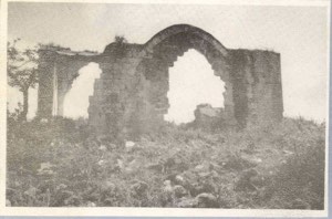
According to the field description published in Walid Khalidi's All That Remains, a few stone houses remained standing at the village site and were used by residents of Elqosh as homes or storage buildings.
Rubble from destroyed houses was scattered across the site, while the former school building remained standing but abandoned.
Fig and olive trees and cactuses also grew at the site.
This description should not be treated as a comprehensive field verification of conditions in 2026. Fieldwork for All That Remains was conducted between 1987 and 1990 and therefore records the state of the site during that survey period.
Sources
- PalQuest – Interactive Encyclopedia of the Palestine Question: Dayr al-Qasi
- PalQuest – Operation Hiram
- Palestine Remembered – Dayr al-Qasi, Acre District
- Palestinian Villages Encyclopedia – Dayr al-Qasi / al-Asi; supporting Palestinian community documentation
- Government of Palestine – Census of Palestine 1922
- Palestinian Central Bureau of Statistics – Historical Census Archive
- Sami Hadawi – Village Statistics 1945; reproduction of the Government of Palestine tables
- Institute for Palestine Studies – Walid Khalidi, All That Remains
- PalQuest – All That Remains: Methodology
Photo gallery


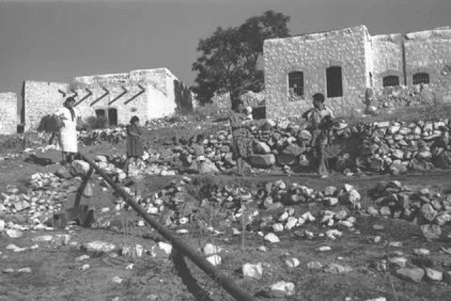


Photos from the village's people
Photos sent in by visitors and published after review.
Add a photo of this village
Log in to add photos of this village.
Other villages from Akka (Acre)
More from the archive



 Download Our Palestine App
The whole archive in the palm of your hand: depopulated villages, the Nakba, the massacres and Al-Aqsa — free, with no ads to erase the story.
Download Our Palestine App
The whole archive in the palm of your hand: depopulated villages, the Nakba, the massacres and Al-Aqsa — free, with no ads to erase the story.



Comments
No comments yet — be the first to write one.
Add your comment
Name and email are optional. Comments appear after review.