
The depopulated village of Al-Ruways / District of Akka (Acre)

Al-Ruways
About the depopulated village of Al-Ruways
- District
- Akka (Acre)
- Date Al-Ruways was occupied
- 15 July 1948
- Population in 1948
- 380
- Military operation
- Operation Dekel
- Distance from the governorate centre
- 12 (km) East of Acre
- Elevation above sea level
- 35 m
- Cause of displacement
- Military assault by Zionist troops
- Extent of destruction
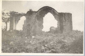
- al-Ruways was completely destroyed, and only house rubble left behind.
- Ethnic cleansing
- al-Ruways inhabitants were completely ethnically cleansed.
Hover a dot to read the village name, or click to open its card.
Borders of the depopulated village of Al-Ruways
Al-Ruways – Depopulated Palestinian Village in Acre Subdistrict
Al-Ruways was a Palestinian village in the Acre subdistrict. It stood on a small rocky hill overlooking the plain of Acre, approximately 12 kilometers from the city of Acre, at an average elevation of about 35 meters above sea level. It was among the smaller villages of the subdistrict in both population and land area.
The village had 330 inhabitants in the official 1944/45 statistics and a registered land area of 1,163 dunums. During the Nakba and the 1948 occupation of Palestine, its population was displaced amid the July 1948 military operations in Galilee. Its occupation was associated with the final phase of Operation Dekel and the advance of units of the Sheva' or Seventh Brigade into western Galilee.
Key Facts about Al-Ruways
| Field | Information |
|---|---|
| Name | Al-Ruways |
| Subdistrict | Acre |
| Status | Depopulated Palestinian village |
| Distance from Acre | Approximately 12 km |
| Average elevation | 35 m above sea level |
| Population, 1944/45 | 330 |
| Registered land area | 1,163 dunums |
| Military operation | Operation Dekel |
| Unit specifically associated with the village's capture | Units of the Sheva' / Seventh Brigade |
| Occupation and depopulation | Mid-July 1948; the exact date differs among sources |
| Cause of depopulation | Bombardment, military advance, and the fall of nearby urban centers and localities |
| Israeli settlements established on village lands | No settlement is documented as having been established directly on Al-Ruways's lands |
Location of Al-Ruways
Al-Ruways stood on a small rocky hill overlooking the Acre plain. A secondary road connected it with the villages of al-Damun and al-Birwa to the north and from there with the Acre–Safad highway. The same route also linked the village with the main Acre–Haifa coastal road.
The village lay close to the lands of al-Damun and Tamra in the eastern part of the Acre plain and along the western approaches to the hills of Galilee.
Al-Ruways before the Nakba
Walid Khalidi records that the village occupied a site associated in Crusader sources with the place-name “Careblier.” In the late nineteenth century, Al-Ruways was described as standing in open country with olive groves to the north. Its population at that time was estimated at about 400, all Muslims.
Al-Ruways was one of the smaller villages of the Acre region. Its houses were initially constructed of stone, while reinforced concrete became increasingly common in new construction from the 1930s onward. The village was divided into two quarters separated by a road.
Population of Al-Ruways
- Late nineteenth centuryAbout 400Historical estimate in the Survey of Western Palestine
- 1922154Official British Mandate census
- 1931217Official British Mandate census
- 1944/45330Official statistics; all classified as Arab
- 1948383Later estimate reported by Palestine Remembered, not an official census
- 19982,351 refugeesLater refugee estimate reported by Palestine Remembered
Number of Houses
- 193144Official 1931 census figure
- 194877Later estimate reported by Palestine Remembered
The figure of 77 houses in 1948 should therefore not be presented as an official census count.
Land Ownership in Al-Ruways
The total registered land area of Al-Ruways in the 1944/45 statistics was 1,163 dunums. Using the terminology of the simplified ownership table presented by Palestine Remembered:
- Palestinian1,159 dunums100%
- Transferred to Zionists0 dunums0%
- Communal/Public4 dunums<1%
This corresponds with the official table, which records 1,159 Arab dunums and 4 Public dunums.
Land Use in 1944/45
For official land-use statistics, the original Arab and Public categories should be retained rather than merged with the simplified ownership categories above.
- Arab
- Public
- Cereals844 dunums
- Plantations and irrigable land222 dunums
- Built-up area15 dunums
- Non-cultivable land82 dunums
A total of 1,066 dunums was classified as cultivated or cultivable, while 97 dunums consisted of built-up and non-cultivable land. Cultivable land therefore accounted for approximately 92 percent of the village's registered area.
Of the 222 dunums devoted to plantations and irrigable land, approximately 40 dunums were planted with olive trees. This is a crop-level detail within the 222-dunum category and should not be added again to the village's total land area.
Economic Life in Al-Ruways
The inhabitants of Al-Ruways depended principally on agriculture. Documented crops included wheat, barley, sesame, watermelons, and olives. The 1944/45 statistics demonstrate the importance of cereal cultivation, with 844 dunums devoted to cereals and 222 dunums to plantations and irrigable cultivation.
Olive cultivation was also part of the village economy, and nineteenth-century descriptions noted olive groves to the north of the village.
Water Resources
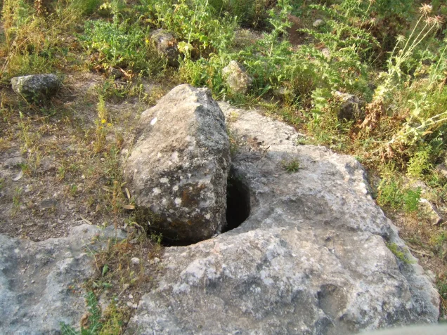
The inhabitants obtained their drinking water principally from domestic wells that collected rainwater during the winter. The village's dependence on household cisterns and wells reflected the local pattern of water supply.
Mosque and Education
Al-Ruways had a mosque serving its residents. No independent village school is documented in the principal source used here; instead, children from Al-Ruways attended school in nearby al-Damun.
The principal sources reviewed do not provide sufficient documentation to establish the existence of a church in Al-Ruways, and this claim has therefore not been included as a verified village institution.
Archaeological Remains
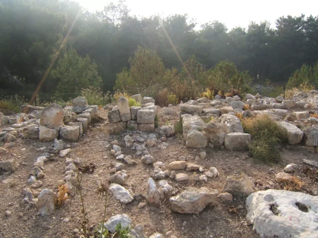
Southwest of Al-Ruways was a ruin containing remains of walls, wells, and rock-cut tombs. Roman milestones were also discovered approximately one kilometer southeast of the village.
These remains indicate earlier activity in the area, but the principal sources do not provide enough archaeological evidence to assign them a more precise historical interpretation.
Operation Dekel
Operation Dekel lasted from 8 to 18 July 1948 and formed part of the Israeli occupation forces' military campaign in lower and western Galilee. Units from the Sheva' / Seventh Brigade, Carmeli Brigade, and Golani Brigade participated in the operation as a whole on different axes and at different stages.
For Al-Ruways specifically, however, Walid Khalidi's account as digitized by PalQuest identifies units of the Sheva' / Seventh Brigade as the forces advancing toward the village. It would therefore be inaccurate to identify every brigade participating in Operation Dekel as a unit that directly entered Al-Ruways.
Occupation and Depopulation of Al-Ruways
The precise date of Al-Ruways's occupation is not entirely consistent across the available sources. Palestine Remembered's summary table gives 15 July 1948, while the detailed narrative derived from Walid Khalidi states that Seventh Brigade units advanced toward several villages in the Acre region, including Al-Ruways, after the occupation of Nazareth on 16 July.
The most cautious formulation is therefore that Al-Ruways was occupied and depopulated in mid-July 1948 during the final phase of Operation Dekel, while noting that the exact day remains inconsistent in the sources.
According to Khalidi, most civilians fled under artillery bombardment and the advancing military forces, or in response to the fall of nearby urban centers and localities, including Nazareth and Shafa 'Amr.
Palestine Remembered classifies the cause of depopulation as a direct military assault and describes the complete removal of the village population as ethnic cleansing. In directly descriptive terms supported by the sources, the village lost its entire Palestinian population amid bombardment, military advance, and the associated displacement, and its community was not subsequently restored to the village.
Occupation Chronology
- 8–18 July 1948
Operation Dekel
A broader military operation in Galilee involving several brigades on different fronts.
- 16 July 1948
Occupation of Nazareth
Khalidi's narrative places the Seventh Brigade's subsequent advance toward Al-Ruways after the capture of Nazareth.
- After 16 July according to the detailed narrative
Advance toward Al-Ruways
Units of the Sheva' / Seventh Brigade moved toward western Galilee villages, including Al-Ruways.
- Mid-July 1948
Population flight
Most residents fled under artillery bombardment, military advance, and the impact of the fall of nearby towns and localities.
- 15 July 1948
Date listed by Palestine Remembered
The site's summary table gives this date, but it conflicts with the chronology of the detailed narrative and is therefore not treated here as conclusively established.
- Precise date not established in the principal sources reviewed
Destruction
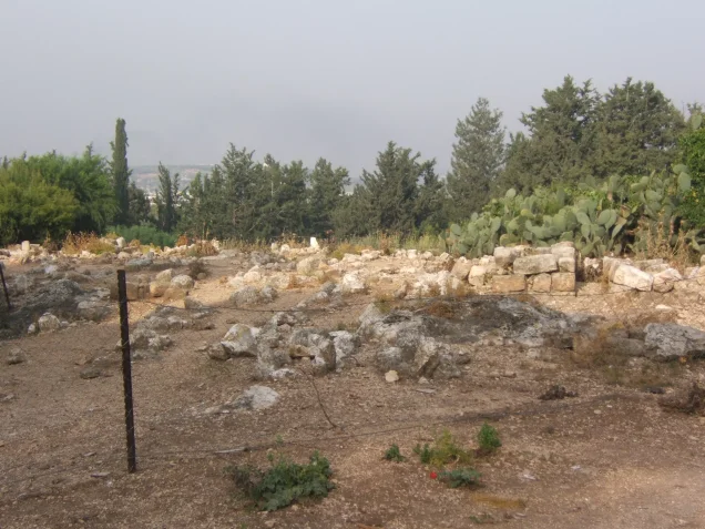
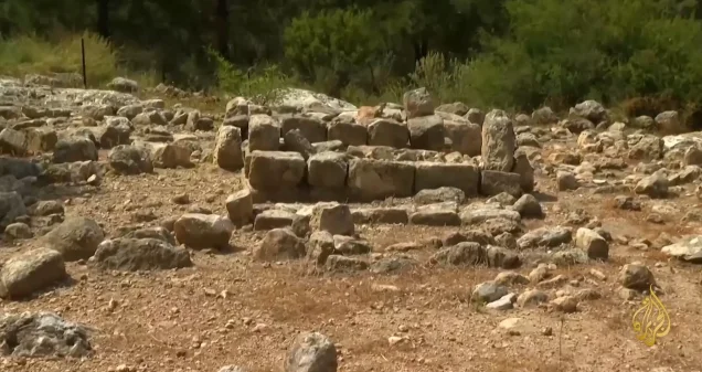
Most village structures were destroyed, leaving debris from wells, concrete roofs, and other structures at the site.
Israeli Settlements and Al-Ruways's Lands
Walid Khalidi and PalQuest do not identify any Israeli settlement as having been established directly on the lands of Al-Ruways.
Yas'ur, established in 1949, lay north of al-Damun rather than on Al-Ruways's village lands. Its residents, however, cultivated lands belonging to Al-Ruways.
| Settlement | Established | Relationship to Al-Ruways |
|---|---|---|
| Yas'ur | 1949 | Not established on Al-Ruways's lands, but its residents cultivated village lands |
Al-Ruways Today
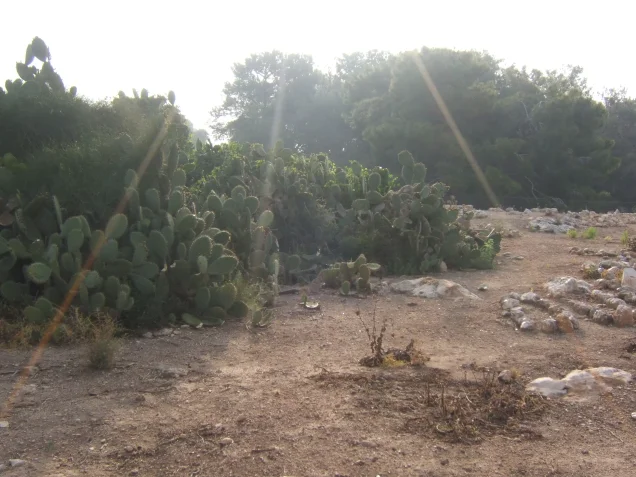
In Walid Khalidi's field description prepared before the publication of All That Remains, the village site was deserted and covered with the debris of old wells and concrete roofs. Eucalyptus trees and cactus plants covered much of the site, while nearby lands were being cultivated by residents of Yas'ur.
This description derives from field research undertaken before the publication of Khalidi's book in 1992. It is therefore a documented historical description of the site's condition at that time and should not be treated as a comprehensive direct field verification of conditions at Al-Ruways in 2026.
Sources
Photo gallery

Photos from the village's people
Photos sent in by visitors and published after review.
Add a photo of this village
Log in to add photos of this village.
Other villages from Akka (Acre)

More from the archive

 Download Our Palestine App
The whole archive in the palm of your hand: depopulated villages, the Nakba, the massacres and Al-Aqsa — free, with no ads to erase the story.
Download Our Palestine App
The whole archive in the palm of your hand: depopulated villages, the Nakba, the massacres and Al-Aqsa — free, with no ads to erase the story.



Comments
No comments yet — be the first to write one.
Add your comment
Name and email are optional. Comments appear after review.