
The depopulated village of Qalunya / District of Al-Quds (Jerusalem)
Subdistrict: Jerusalem Subdistrict
Estimated Palestinian population of Qalunya in 1948: Approximately 1,060
Date of occupation and final destruction: 11 April 1948
Military operation and units: Operation Nachshon; Palmach units of the Haganah
Jewish settlements established near Qalunya before 1948: Motza. Although some statistical records grouped Motza with Qalunya, scholarly sources indicate that it was situated close to, rather than on, Qalunya’s village lands.
Israeli settlement established on Qalunya’s lands after 1948: Mevaseret Yerushalayim, established in 1956 and later incorporated into Mevaseret Zion
Reported village land located on the Israeli-controlled side of the 1949 Armistice Line: 4,389 dunams. This figure should be treated as an estimate because classifications vary between sources.
Qalunya was a Palestinian village in the Jerusalem Subdistrict that was occupied and depopulated during the Nakba in 1948. Its former lands and surviving structures now lie along the western approaches to al-Quds (Jerusalem), near Motza and Mevaseret Zion.
Geography of Qalunya
Qalunya was located approximately 6 kilometres west of al-Quds (Jerusalem), at an average elevation of about 650 metres above sea level.
The village stood on a mountain slope facing southwest, while Wadi Qalunya passed along its eastern edge. Qalunya lay beside the main al-Quds–Yafa road, and unpaved roads connected it with neighbouring Palestinian villages.
Boundaries and Neighbouring Villages
Qalunya was surrounded by the following Palestinian villages and towns:
- North: Bayt Surik.
- West: Al-Qastal.
- Southwest: Sataf.
- South: Ayn Karim.
- Southeast: Deir Yasin.
- East: Lifta.
- Northeast: Bayt Iksa.
Architectural Character of Qalunya
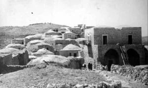
Qalunya had a broadly circular layout. Most of its houses were constructed of stone and were separated by winding lanes that divided the village into several quarters. Newer buildings initially extended northwestward and later southward, broadly following the al-Quds–Yafa road.
Qalunya before the Nakba
In the late nineteenth century, Qalunya was described as a medium-sized village situated on a hillside approximately 300 feet above the valley. Contemporary survey accounts noted the presence of what was described at the time as a “modern” restaurant. The villagers cultivated orange and lemon trees around a spring in the valley.
In 1859, Jewish immigrants acquired agricultural land in the vicinity of Qalunya. It was reportedly the first such acquisition in the Palestinian countryside. Some settlers cultivated the land but did not initially reside there permanently. The small Jewish settlement of Motza developed nearby during the early twentieth century. Although British Mandate statistics grouped Motza with Qalunya for certain demographic and land records, Walid Khalidi’s village study states that Motza was close to, but not situated on, Qalunya’s village lands.
By the mid-1940s, Qalunya’s Palestinian population comprised approximately 900 Muslims and 10 Christians. The total of 1,260 reported in the British Mandate’s 1945 Village Statistics also included 350 Jewish residents of the nearby settlement of Motza. The village mosque, known as the Shaykh Hamad Mosque, stood on the eastern side of Qalunya.
Economic Life in Qalunya
The villagers obtained water from springs surrounding the village. Agriculture combined rainfed and irrigated cultivation. The land produced cereals, vegetables, fruit, olives and grapes.
In 1944/45, Palestinian-owned land included 846 dunams allocated to cereal cultivation and 1,022 dunams classified as irrigated land or orchards. Approximately 200 dunams of the latter were planted with olive trees.
Labour, Social and Cultural Life
Local accounts describe an active social, health, cultural and labour life in Qalunya. Many village workers reportedly belonged to the Arab Workers Society or other Palestinian labour organisations. A local committee representing the village’s families administered community affairs.
According to accounts preserved by residents and descendants, Qalunya had licensed midwives, traditional bone-setters and a village resident employed by the public health authorities who participated in vaccinating children. Because these details derive primarily from community accounts, they should be understood as elements of Qalunya’s locally documented social history.
Young villagers founded a cultural and athletic association known as the National Club. Its activities reportedly included staging the play Wa Mu'tasimah and participating in local sporting competitions. The village also had one mosque, an elementary school and several shops.
Archaeological Remains in Qalunya
Recorded archaeological remains included the ruins of an arched structure. Two khirbas north of the village contained foundations of older buildings and caves carved into the rock.
Locally recorded archaeological sites associated with Qalunya include:
- Khirbat Bayt Mazza.
- Khirbat Bayt Talma.
Land Ownership in Qalunya, 1944/45
The British Mandate’s Village Statistics grouped Qalunya and Motza in the following land figures. The table therefore does not represent Palestinian Qalunya in isolation.
| Ownership category | Area (dunams)* |
|---|---|
| Palestinian ownership | 3,594 |
| Jewish ownership | 1,084 |
| Public land | 166 |
| Total | 4,844 |
* One dunam equals approximately 1,000 square metres.
Land Use in Qalunya and Motza, 1944/45
The following figures are derived from the British Mandate’s Village Statistics. They include Motza and distinguish between land under Palestinian ownership, Jewish ownership and public land.
| Land-use category | Palestinian ownership (dunams)* | Jewish ownership (dunams)* | Public land (dunams)* | Total (dunams)* |
|---|---|---|---|---|
| Irrigated land and orchards | 1,022 | 202 | — | 1,224 |
| Olive cultivation, included within the preceding category | 200 | 0 | — | 200 |
| Cereal cultivation | 846 | 109 | — | 955 |
| Built-up area | 78 | 149 | — | 227 |
| Cultivable land | 1,868 | 311 | — | 2,179 |
| Uncultivated land | 1,648 | 624 | 166 | 2,438 |
* One dunam equals approximately 1,000 square metres.
Population of Qalunya
Population figures must be interpreted carefully because some British Mandate records combined Qalunya with the neighbouring Jewish settlement of Motza. The 1945 total of 1,260 consisted of 910 Palestinians in Qalunya and 350 Jewish residents in Motza.
| Year | Recorded or estimated population | Notes |
|---|---|---|
| 1596 | Approximately 110 | Estimated from 19 Muslim households recorded in Ottoman tax registers. |
| 1922 | 549 | The census recorded 456 Muslims, 88 Jews and 5 Orthodox Christians. |
| 1931 | 632 | The census recorded 622 Muslims and 10 Christians in 156 houses. |
| 1945 | 1,260 | Combined statistical total: 910 Palestinians in Qalunya and 350 Jewish residents in Motza. |
| 1948 | Approximately 1,060 Palestinians | Projected estimate rather than a new official census. Estimates vary slightly between sources. |
| 1998 | Approximately 6,483 refugees and descendants | A retrospective estimate published by Palestine Remembered, not an official census of a single resident population. |
Number of Houses in Qalunya
| Year | Number of houses | Status of figure |
|---|---|---|
| 1931 | 156 | Recorded in the British Mandate census. |
| 1948 | Approximately 260 | Later estimate; no comparable official 1948 village census has been identified. |
Occupation and Depopulation of Qalunya
Qalunya was one of the principal targets of Operation Nachshon. According to the History of the Haganah, Palmach units attacked the village on 11 April 1948. Israeli historian Benny Morris and Haganah records state that the occupying forces spent two days demolishing and levelling houses. A contemporary report published by The New York Times likewise stated that Haganah forces entered Qalunya on 11 April, demolished numerous houses and set the village ablaze.
Sources differ over the precise sequence of Qalunya’s depopulation. Morris maintains that residents had already begun leaving on 2 or 3 April following an earlier attack. A contemporary Irgun broadcast attributed their departure to the impact of the Deir Yasin massacre of 9 April. A newspaper correspondent reported that most villagers had been evacuated before the final assault and that those who remained were expelled before the village was destroyed. These accounts establish a process of displacement culminating in the Palmach assault, occupation and destruction of 11–12 April, but they do not support a single undisputed date for the departure of every resident.
An eyewitness who accompanied the Palmach force, Harry Levin, recorded mortar fire, the entry of assault troops and sappers, and the demolition of stone houses. He counted at least fourteen dead while acknowledging that the total may have been higher. This figure is an eyewitness estimate rather than a complete casualty register.
Qalunya Today
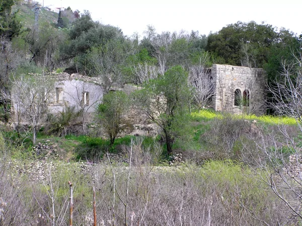
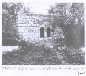
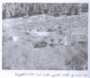
Only a small number of houses survive in the southwestern part of the village site near the cemetery. These buildings retain arched doors and windows, and one was reported to be occupied by a Jewish family. Stone rubble, sections of collapsed concrete roofs and iron window frames remain scattered across the site.
A synagogue constructed in 1871 also survives, with arched entrances and windows. The village’s agricultural terraces remain visible, and almond, fig and olive trees continue to grow on the slopes alongside cactus plants. Wild vegetation at the site has periodically been burned or cleared near the adjoining Israeli-built areas.
Israeli Settlements on and near Qalunya’s Lands
Mevaseret Yerushalayim was established on Qalunya’s lands in 1956. It was later joined with Ma'oz Zion, which had been established in 1951 on the lands of the neighbouring Palestinian village of Al-Qastal. Together, they formed the Israeli suburb now known as Mevaseret Zion, located northwest of the former village site and extending over a substantial part of Qalunya’s land.
Motza was established close to Qalunya on land acquired by Jewish settlers during the nineteenth century. It was rebuilt as Motza Tahtit in 1930, and Motza Illit was established nearby in 1933. Walid Khalidi’s account distinguishes these settlements from Mevaseret Yerushalayim, noting that Motza and Motza Illit were close to Qalunya but not established on its village lands.
Sources
- Interactive Encyclopedia of the Palestine Question (PalQuest), “Qalunya”. The entry draws substantially on Walid Khalidi’s All That Remains.
- Palestine Remembered, “Qalunya—Jerusalem”.
- Palestine Open Maps, “Qalunya”.
- Our Palestine, “Village of Qalunya”.
- Government of Palestine, Department of Statistics, Village Statistics, April 1945.
- Government of Palestine, Census of Palestine, 1922 and Census of Palestine, 1931.
- Walid Khalidi, ed., All That Remains: The Palestinian Villages Occupied and Depopulated by Israel in 1948, Institute for Palestine Studies, 1992, pp. 309–311.
Photo gallery


Photos from the village's people
Photos sent in by visitors and published after review.
Add a photo of this village
Log in to add photos of this village.
Other villages from Al-Quds (Jerusalem)
 Download Our Palestine App
The whole archive in the palm of your hand: depopulated villages, the Nakba, the massacres and Al-Aqsa — free, with no ads to erase the story.
Download Our Palestine App
The whole archive in the palm of your hand: depopulated villages, the Nakba, the massacres and Al-Aqsa — free, with no ads to erase the story.



Comments
No comments yet — be the first to write one.
Add your comment
Name and email are optional. Comments appear after review.