
The depopulated village of Dayr Yasin / District of Al-Quds (Jerusalem)
About the depopulated village of Dayr Yasin
- District
- Al-Quds (Jerusalem)
- Date Dayr Yasin was occupied
- 09 April 1948
- Population in 1948
- 710
- Brigade that carried it out
- The terror gangs of Irgun Zvai Leumi (IZL or ETZEL) and Stern Gang (LEHI) headed by the former Israeli Prime Minister Menachem Begin
- Who defended the village
- Local village militia
- Distance from the governorate centre
- 5.5 (km) West of Jerusalem
- Elevation above sea level
- 780
- Cause of displacement
- Expulsion by Zionist troops
- Ethnic cleansing
- Dayr Yasin inhabitants were completely ethnically cleansed.
- Settlements built on the built-up area of Dayr Yasin after 1948
- Nof and Giv'at Shaul Bet, Jerusalem
Hover a dot to read the village name, or click to open its card.
Borders of the depopulated village of Dayr Yasin
The Depopulated Palestinian Village of Deir Yasin
```Deir Yasin was a depopulated Palestinian village in the Jerusalem Subdistrict. It stood on the eastern slopes of a high hill approximately five kilometers west of the center of Jerusalem.
The village became associated with one of the best-known massacres committed by Zionist armed organizations during the 1948 war. On 9 April 1948, Irgun and Lehi forces attacked Deir Yasin with assistance from Haganah and Palmach personnel. Around one hundred villagers, including women, children, and elderly people, were killed during the assault and massacre. A later Birzeit University field study documented the names of 107 victims.
Basic Information
| Field | Information |
|---|---|
| District | Jerusalem. |
| Historical Administrative Location | Jerusalem Subdistrict, Mandatory Palestine. |
| Distance from District Center | Approximately 5 km from central Jerusalem. |
| Direction | West of Jerusalem. |
| Average Elevation | Approximately 780 meters above sea level; the hilltop on which the village stood reached about 800 meters. |
| Population in 1922 | 254 inhabitants according to the official census. |
| Population in 1931 | 429 inhabitants according to the official census: 428 Muslims and one Jewish resident. PalQuest lists 428, corresponding to the Arab/Muslim population. |
| Occupied Houses in 1931 | 91 according to the official census. |
| Arab Population in 1944/1945 | 610 inhabitants. |
| Jewish Population in 1944/1945 | 0. |
| Total Population in 1944/1945 | 610 inhabitants. |
| Estimated Population in 1948 | Approximately 750 according to Walid Khalidi and PalQuest; Palestine Remembered gives an estimate of approximately 708. |
| Estimated Houses in 1948 | Approximately 144 according to Walid Khalidi/PalQuest. |
| Total Land Area | 2,857 dunums. |
| Land Ownership in 1944/1945 | Palestinian: 2,701 dunums; Transferred to Zionists: 153 dunums; Public/Common: 3 dunums. |
| Date of Attack and Depopulation | 9 April 1948. |
| Later Transfer of Control | Irgun and Lehi seized the village on 9 April. Contemporary reports said the Haganah took control on 10 April, while a later report described the village as being formally occupied on 11 April 1948. |
| Military Operation | The occupation of Deir Yasin fell within the broader military framework of Operation Nachshon, the Haganah campaign in the Jerusalem area and along the Jerusalem–Jaffa road. |
| Military Units | Irgun and Lehi were the principal attacking forces. A Palmach unit intervened with mortar support, while Haganah command supplied ammunition and military assistance. |
| Cause of Depopulation | Military assault, massacre, and expulsion. The village was emptied during and immediately after the attack, and the surviving inhabitants were not permitted to return. |
| Extent of Destruction | Parts of the village were blown up or demolished during and after the assault, but Deir Yasin was not completely erased. Many stone houses survived and were later incorporated into the Kfar Shaul hospital complex. |
| Settlements Established before 1948 on Village Land | No pre-1948 settlement on Deir Yasin land was confirmed in the sources used. Giv'at Shaul, established around 1906, was a neighboring settlement across the valley. |
| Settlements Established after 1948 on Village Land | Giv'at Shaul Bet – 1949. The Kfar Shaul Mental Health Center was also established within the village site and incorporated surviving Palestinian buildings. |
Occupation Chronology
| Date | Stage | Details |
|---|---|---|
| January 1948 | Non-aggression agreement | Notables from Deir Yasin and representatives of neighboring Giv'at Shaul reached an understanding intended to preserve mutual quiet and non-aggression and to exchange information about armed groups entering the area from outside. |
| 3 April 1948 | Beginning of Operation Nachshon | The Haganah launched Operation Nachshon to open the Tel Aviv–Jerusalem road and seize strategic positions and villages along it. The later occupation of Deir Yasin fell within the operation's broader framework. |
| Early April 1948 | Decision to attack Deir Yasin | Irgun and Lehi commanders decided to attack the village amid the fighting west of Jerusalem. Haganah command in Jerusalem knew of the plan and approved the attack on condition that the attackers were able to retain the village after seizing it. |
| Dawn, 9 April 1948 | Beginning of the assault | Approximately 120 Irgun and Lehi fighters attacked Deir Yasin from several directions. Local defenders resisted and initially stalled the attackers' advance. |
| 9 April 1948 | Palmach and Haganah intervention | After the initial assault stalled, a Palmach unit intervened with mortar support, while Haganah command supplied ammunition and other military assistance. |
| 9 April 1948 | Massacre and seizure of the village | Irgun and Lehi forces entered the village and widespread killings took place, including the killing of women, children, and elderly residents. Houses were blown up during and after the fighting, and prisoners and survivors were removed from the village. |
| 9 April 1948 | Depopulation | Deir Yasin was emptied of its Palestinian inhabitants during the assault, massacre, and their immediate aftermath. Survivors were not permitted to return. |
| 10 April 1948 | Reported Haganah takeover | Contemporary press reports initially stated that the Haganah took control of Deir Yasin on the day following the massacre. |
| 11 April 1948 | Formal occupation according to a later press report | A later New York Times report stated that the Haganah formally occupied the village on 11 April. This should be distinguished from the Irgun-Lehi seizure on 9 April. |
| 11 April 1948 | International Committee of the Red Cross visit | Jacques de Reynier, head of the ICRC delegation in Jerusalem, entered Deir Yasin, saw victims' bodies inside and outside houses, and was able to remove a small number of wounded survivors. |
| Summer 1949 | Post-depopulation settlement | Several hundred Jewish immigrants were settled near the Deir Yasin site, and the new settlement was named Giv'at Shaul Bet. |
| 1951 | Reuse of village buildings | The Kfar Shaul Mental Health Center was established at the village site, incorporating a number of surviving Palestinian houses. |
Location and Geography
Deir Yasin was built on the eastern slopes of a hill whose summit reached approximately 800 meters above sea level. PalQuest gives the village's average elevation as approximately 780 meters. The site commanded a broad view of the surrounding area.
A terraced valley separated the village from the western suburbs of Jerusalem. Olive, almond, and fig trees and grapevines were cultivated on its terraces. A secondary road along the northern edge of the valley connected Deir Yasin with Jerusalem's suburbs and with the main Jerusalem–Jaffa road, approximately two kilometers to the north.
Lifta lay to the northeast, Ayn Karim to the southwest, and Qalunya to the northwest. The neighboring settlement of Giv'at Shaul stood across the valley from Deir Yasin.
Origin of the Name
The Arabic word deir refers to a monastery or religious structure. A large ruin at the southwestern edge of the village was known simply as “the Deir.”
The second part of the name is associated with Shaykh Yasin, whose tomb stood inside a mosque bearing his name near the ruins of the Deir. The sources used do not establish precisely when the population shifted from Khirbat Ayn al-Tut to the later village site or when Shaykh Yasin's mosque was constructed.
Some local accounts also preserve the earlier name “Deir al-Nasr” in connection with the site.
Architecture
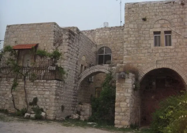
Most houses in Deir Yasin were built of stone. The older houses were concentrated in an area known as the Hara, or quarter, which was characterized by narrow winding lanes and strongly built houses with thick walls.
As the village economy prospered during the British Mandate, construction expanded uphill and eastward toward Jerusalem, and larger stone houses appeared outside the older core.
The village contained two mosques, two elementary schools, a bakery, two guesthouses, a social club known as the Renaissance Club, a thrift fund, three shops, and four wells. A second mosque overlooking the village from the upper slopes was built by Mahmud Salah, a prosperous villager.
Archaeological Sites
Both Deir Yasin and nearby Khirbat Ayn al-Tut contained archaeological evidence of earlier settlement, including walls, arches, cisterns, and tombs. A large ruin known simply as the “Deir” stood on the southwestern edge of the village.
Khirbat Ayn al-Tut lay approximately 500 meters west of the 1948 village site. Walid Khalidi suggests that it may have formed the nucleus of settlement in the early Ottoman period. In 1596 it had an estimated population of 39 and paid taxes on wheat, barley, and olive trees.
Economic Life
Until the 1920s, the inhabitants of Deir Yasin depended largely on agriculture and livestock raising. They cultivated cereals, olives, almonds, figs, and grapes on the surrounding terraces.
The expansion of construction in Jerusalem transformed the village economy during the Mandate. The surrounding area contained hard limestone well suited for construction, and stone quarried around Deir Yasin became known locally for its quality and its use in Jerusalem buildings.
Villagers developed extensive quarries and stone-crushing operations along the road to Jerusalem. By the late 1940s four stone crushers were operating. Quarrying, stone processing, transport, and trucking became major sources of income, while other villagers worked in nearby British military camps or in the Mandatory civil service.
In 1935, residents of Deir Yasin and neighboring Lifta jointly established a local bus company. By the end of the Mandate, no more than about 15 percent of the village population was engaged primarily in agriculture.
Education and Social Life
During the early Mandate period, children from Deir Yasin attended schools in neighboring Lifta and Qalunya. An elementary school for boys was established in the village in 1943, followed by a girls' school in 1946.
Both schools were built through contributions from the villagers. The girls' school was headed by a resident schoolmistress from Jerusalem.
The Renaissance Club served social and cultural functions in the village, while a local thrift fund also served the community.
Population and Houses
The population of Deir Yasin was overwhelmingly Palestinian Arab and Muslim. The official 1922 census recorded 254 inhabitants.
The official 1931 census recorded 429 people living in 91 occupied houses: 428 Muslims and one Jewish resident. Walid Khalidi/PalQuest gives 428 when describing the village population, corresponding to the Muslim/Arab component of the official census.
The official 1944/1945 statistics listed 610 Arab inhabitants. For 1948, Walid Khalidi and PalQuest estimate approximately 750 residents in 144 houses, while Palestine Remembered gives an estimate of approximately 708.
Population of Deir Yasin
- 159639Population of Khirbat Ayn al-Tut, not a census of the later 1948 Deir Yasin site.
- 1922254Official census.
- 1931429Official census: 428 Muslims and one Jewish resident; PalQuest lists 428.
- 1944/1945610Official estimate of the Arab population.
- 1948Approximately 750Walid Khalidi/PalQuest estimate; Palestine Remembered gives approximately 708.
Number of Houses in Deir Yasin
- 193191Occupied houses in the official census.
- 1948Approximately 144Walid Khalidi/PalQuest estimate on the eve of the Nakba.
Land Ownership in 1944/1945
The officially recorded land area of Deir Yasin totaled 2,857 dunums. The Mandatory Village Statistics classified 2,701 dunums as Arab-owned, 153 dunums as Jewish-owned, and 3 dunums as public land. In the terminology used by this project, these categories are presented as Palestinian, Transferred to Zionists, and Public/Common.
Land Ownership in Deir Yasin
- Palestinian2,701 dunums95%
- Transferred to Zionists153 dunums5%
- Public/Common3 dunums<1%
Land Use in 1944/1945
The Village Statistics classified 866 dunums as cereal and cultivable land, including 756 dunums of Palestinian-owned land and 110 dunums of land transferred to Zionists. The village's built-up area covered 12 dunums.
Separate agricultural records mention approximately 200 dunums planted with olive trees. This figure should not be added again to the village's total land area because it is an overlapping agricultural classification.
Land Use in Deir Yasin, in Dunums
- Palestinian
- Transferred to Zionists
- Public/Common
- Cereal / classified cultivable land866 dunums
- Built-up area12 dunums
- Non-cultivable land1,979 dunums
Conditions before the Attack
In January 1948, notables from Deir Yasin and representatives of neighboring Giv'at Shaul reached a non-aggression understanding intended to preserve mutual quiet and to exchange information regarding armed groups entering the area from outside.
Despite this agreement, Irgun and Lehi commanders planned an attack on Deir Yasin during the fighting west of Jerusalem. Haganah command in Jerusalem knew of the plan. Its commander, David Shaltiel, informed the attackers that taking and holding the village fitted within the Haganah's broader Operation Nachshon plan and approved the attack provided they could retain the position.
The Deir Yasin Massacre
At dawn on Friday, 9 April 1948, approximately 120 fighters from Irgun and Lehi attacked Deir Yasin. Sources reproduced by Walid Khalidi state that Haganah command knew of the operation and supplied ammunition and military support during the fighting.
The attackers advanced from several directions but encountered resistance from the village's defenders and suffered casualties and wounded. After the initial assault stalled, a Palmach unit intervened with mortar support, helping the attackers overcome the remaining resistance and enter the village.
Widespread killings followed in parts of the village. Men, women, children, and elderly residents were among those killed, houses were blown up during and after the fighting, and a number of prisoners were killed after capture.
Some prisoners and survivors were placed on trucks and taken through neighborhoods of West Jerusalem in what historical accounts described as a “victory procession.” Some were later released in Arab areas, while historical testimony records that a group of male prisoners was killed after capture.
On 11 April, Jacques de Reynier, head of the International Committee of the Red Cross delegation in Jerusalem, entered Deir Yasin. He saw victims' bodies inside and outside houses and was able to remove a small number of wounded survivors.
Number of Victims
Figures exceeding 250 deaths circulated immediately after the massacre and appeared in contemporary statements and press reports. Material reproduced by Walid Khalidi also records that the official History of the Haganah cited 245 victims.
A later field study by Sharif Kanaana and Nihad Zeitawi for Birzeit University's Destroyed Palestinian Villages Documentation Project reviewed victim names and survivors' testimony and documented 107 deaths and 12 wounded. A figure of roughly 100–110 deaths therefore corresponds more closely to the later name-based investigation than the much higher figures circulated immediately after the massacre.
Regardless of the numerical dispute, Palestinian historical sources and the testimony of the International Committee of the Red Cross document widespread killing of civilians during and after the assault.
Occupation and Depopulation
Deir Yasin was attacked and effectively seized on 9 April 1948. Its Palestinian population was removed during the massacre and its immediate aftermath through flight under attack, forced removal, and expulsion.
The Irgun-Lehi seizure on 9 April should be distinguished from the Haganah's later assumption of control. The New York Times initially reported that the Haganah occupied the village on 10 April and later stated that it was formally occupied on 11 April.
The massacre had a major impact on Palestinian society. News of the killings spread rapidly through towns and villages, and fear that similar attacks could be repeated contributed to further waves of displacement during the Nakba.
Settlement on the Lands of Deir Yasin
In the summer of 1949, several hundred Jewish immigrants were settled near the Deir Yasin site. The new settlement was named Giv'at Shaul Bet after the neighboring Giv'at Shaul settlement, which had been established around 1906.
In 1951, the Kfar Shaul Mental Health Center was established within the village site and incorporated a number of surviving Palestinian houses. As West Jerusalem expanded, Israeli urban development spread across large parts of the village lands, and neighboring Giv'at Shaul expanded over the eastern sector of the former village.
Deir Yasin Today
The detailed site description available through Walid Khalidi and PalQuest is based largely on field documentation and photographs dating to 1986. It should therefore be treated as a historical description of the site rather than a current field verification for 2026.
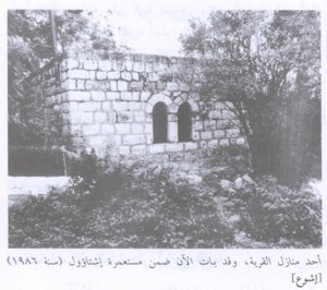
According to that documentation, many of Deir Yasin's stone houses remained standing on the hill and were incorporated into the Kfar Shaul hospital complex. Some surviving buildings outside the hospital grounds were used for residential, commercial, or storage purposes.
Carob and almond trees, remnants of olive trunks, and several wells were also documented near the southwestern edge of the village site.
The old village cemetery, on the eastern or southeastern side of the site, was described as neglected and affected by debris from the ring road constructed around the hill. A tall solitary cypress tree still stood in the cemetery when Walid Khalidi's photographic documentation was made.
Photo gallery


Photos from the village's people
Photos sent in by visitors and published after review.
Add a photo of this village
Log in to add photos of this village.
Other villages from Al-Quds (Jerusalem)
More from the archive
 Al-Quds (Jerusalem)
The depopulated village of Khirbat al-Tannur - Allar al-Sifla / District of Al-Quds (Jerusalem)
 Al-Quds (Jerusalem)
The depopulated village of Jarash / District of Al-Quds (Jerusalem)
 Al-Quds (Jerusalem)
The depopulated village of al-Burayj (Bayarat Burayj) / District of Al-Quds (Jerusalem)
 Download Our Palestine App
The whole archive in the palm of your hand: depopulated villages, the Nakba, the massacres and Al-Aqsa — free, with no ads to erase the story.
Download Our Palestine App
The whole archive in the palm of your hand: depopulated villages, the Nakba, the massacres and Al-Aqsa — free, with no ads to erase the story.



Comments
No comments yet — be the first to write one.
Add your comment
Name and email are optional. Comments appear after review.