
The depopulated village of al-Burayj (Bayarat Burayj) / District of Al-Quds (Jerusalem)

al-Burayj (Bayarat Burayj)
About the depopulated village of al-Burayj (Bayarat Burayj)
- District
- Al-Quds (Jerusalem)
- Date al-Burayj (Bayarat Burayj) was occupied
- 19 October 1948
- Population in 1948
- 840
- Military operation
- Operation Ha-Har
- Distance from the governorate centre
- 28.5 (km) West of Jerusalem
- Elevation above sea level
- 250 m
- Cause of displacement
- Military assault by Zionist troops
- Extent of destruction
- al-Burayj was mostly destroyed and defaced.
- Ethnic cleansing
- al-Burayj inhabitants were completely ethnically cleansed.
Hover a dot to read the village name, or click to open its card.
Borders of the depopulated village of al-Burayj (Bayarat Burayj)
al-Burayj (Bayarat Burayj) – Depopulated Palestinian Village of Jerusalem
Al-Burayj, also known as Bayarat Burayj, was a Palestinian village in the Jerusalem Subdistrict. It stood on hilly ground between two wadis approximately 28.5 kilometers from Jerusalem and at an average elevation of about 250 meters above sea level.
A secondary road west of the village connected it with the highway linking Bayt Jibrin to the Jerusalem-Jaffa road, while dirt roads connected al-Burayj with Zakariyya, 'Ajjur, Dayr Aban, Dayr Rafat, Bayt Jimal, Khirbat Bayt Far, and other neighboring communities.
The village had 720 inhabitants in the official 1944/45 statistics: 710 Muslims and 10 Christians. Its lands covered 19,080 dunums. The economy was based largely on rain-fed agriculture, particularly cereals, vegetables, fruit trees, and olives, together with livestock raising.
Israeli forces captured al-Burayj during Operation ha-Har in the second half of October 1948. Khalidi and PalQuest conservatively date the fall of the village to sometime between 19 and 24 October, while Palestine Remembered and Palestinian local documentation use 19 October as the probable date of occupation and depopulation.
Basic Information
| Field | Information |
|---|---|
| Name | al-Burayj |
| Arabic name | البُرَيْج |
| Alternative name | Bayarat Burayj |
| Subdistrict | Jerusalem |
| Location | Southwest of Jerusalem on hilly ground between two wadis |
| Distance from Jerusalem | Approximately 28.5 km |
| Average elevation | Approximately 250 m above sea level |
| Palestine Grid | 143/127 |
| Population in 1922 | 398, all Muslims |
| Population in 1931 | 621: 614 Muslims and 7 Christians |
| Houses in 1931 | 132 |
| Population in 1944/45 | 720: 710 Muslims and 10 Christians |
| 1948 population estimate | 835 in Palestine Remembered; another Palestinian secondary source rounds the estimate to 840 |
| Total land area | 19,080 dunums |
| Probable occupation date | 19 October 1948; Khalidi/PalQuest conservatively give 19–24 October |
| Military operation | Operation ha-Har – first phase |
| Military unit | Har'el Brigade – strongest attribution; specific battalion not independently established |
| Cause of depopulation | Military assault and shelling during Operation ha-Har, followed by flight and/or expulsion eastward; individual circumstances are incompletely documented |
| Destruction | Most of the built environment was destroyed; the site later became part of a closed military base |
| Post-1948 settlement | Sedot Mikha, founded on village land south of the site in 1955 |
Name
Al-Burayj is the diminutive form of the Arabic word al-burj, meaning “tower.”
Khalidi connects the term with the Greek word purgos, also meaning tower.
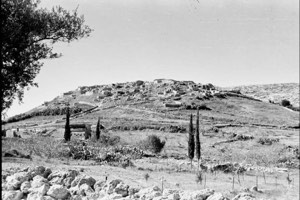
The nineteenth-century Survey of Western Palestine described the locality as a small village on high ground with a prominent elevated house or tower in its center, from which the name was said to derive.
Location and Geography
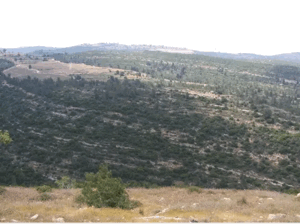
The village stood on a plateau between two wadis, one to the north and the other to the south.
A secondary road west of the village linked it with the road from Bayt Jibrin to the Jerusalem-Jaffa highway.
Dirt tracks connected al-Burayj with neighboring villages including Zakariyya, 'Ajjur, Bayt Jimal, Dayr Aban, Dayr Rafat, Sajad, and Khirbat Bayt Far.
Built Environment
The houses of al-Burayj were originally dispersed irregularly across the site.
Later construction followed the roads approaching the village from several directions, gradually giving the settlement a star-shaped plan.
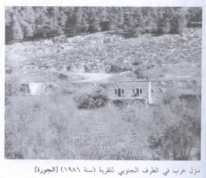
The houses were built mainly of stone and cement.
The built-up area covered fourteen dunums in the 1944/45 statistics.
Population
- 1922398Official Government of Palestine census; 191 males and 207 females, all Muslims
- 1931621Official census: 614 Muslims and 7 Christians in 132 houses
- 1944/45720Official figure: 710 Muslims and 10 Christians
- 1948835Later Palestine Remembered estimate; another Palestinian source gives approximately 840
- 19985,129Later Palestine Remembered estimate of refugees and descendants
Correction to the 1922 Population
Several later Palestinian references reproduce a figure of 382 inhabitants for 1922.
The original Government of Palestine census table, however, records 191 males and 207 females at Buraij, for a total of 398 inhabitants.
This article therefore uses 398 as the direct official census figure while preserving the existence of the secondary discrepancy.
Number of Houses
The official 1931 census recorded 132 houses.
No new official house census was conducted in 1948, so no house total is inferred from the later population estimate.
Land Ownership, 1944/45
- Palestinian18,856 dunums99%
- Transferred to Zionists0 dunums0%
- Public224 dunums1%
The figures balance exactly: 18,856 + 224 = 19,080 dunums.
No land was recorded in the Jewish ownership category.
Land Use, 1944/45
- Palestinian
- Public
- Cereals9,426 dunums
- Plantations and irrigable land77 dunums
- Citrus and bananas31 dunums
- Built-up area14 dunums
- Non-cultivable land9,532 dunums
The land-use categories reconcile exactly with the total village area.
Olive Groves and Double Counting
Palestine Remembered records approximately eighty-eight dunums of olive trees.
This should be understood as a subcategory within cultivated land rather than as an additional acreage added on top of the total land-use categories.
Economy and Agriculture
Al-Burayj depended primarily on rain-fed agriculture.
Cereals were the largest cultivated category, occupying 9,426 dunums in 1944/45.
The villagers also cultivated vegetables, fruit trees, particularly olives, and small areas of citrus and bananas.
Wild trees, grasses, and herbs grew across uncultivated portions of the village lands, providing grazing for livestock and firewood for domestic use.
Education
Palestinian local documentation records an elementary school at al-Burayj providing instruction through the fourth grade.
Khalidi and PalQuest do not provide a documented founding date, enrollment figure, or teacher total.
The school is therefore included on the basis of Palestinian community documentation without adding unsupported numerical details.
al-'Umari Mosque
Al-Burayj had one mosque known as the al-'Umari Mosque.
Khalidi suggests that its name may have referred to Caliph 'Umar ibn al-Khattab.
Palestinian local tradition describes a large stone building with columns, arches, and two arcades and attributes it to the early Islamic period. This chronological attribution is treated as local tradition rather than as an independently established architectural date.
Greek Orthodox Monastery
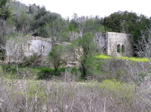
A Greek Orthodox monastery stood west of the village.
Its presence is directly documented in Khalidi's village description.
Al-Burayj had seven Christians in 1931 and ten in 1945, although the sources do not establish whether the monastery served this small group alone or a wider regional religious community.
Archaeology
Several khirbas lay along the boundaries of al-Burayj.
They contained cisterns, rock-cut winepresses, tombs, building foundations, columns, mosaic floors, and caves.
These remains demonstrate a long history of activity in the area but cannot all be assigned to one archaeological period without more specialized evidence.
Operation ha-Har
Operation ha-Har began on 19 October 1948 and ended on 24 October.
Har'el and Etzioni were the principal brigades in the offensive, with Giv'ati also participating at the broader operational level.
The objective was to widen the Israeli-held Jerusalem corridor and connect it with territory captured toward the Hebron hills, in coordination with Operation Yoav farther south.
Al-Burayj was one of the villages directly affected by the operation.
Occupation of al-Burayj
The exact day of occupation is not completely uniform across the sources.
Khalidi and PalQuest state that al-Burayj fell sometime between 19 and 24 October 1948 during the first phase of Operation ha-Har.
Palestine Remembered and Palestinian local documentation use 19 October 1948 as the occupation date.
Palestinian oral testimony from nearby Dayr Rafat also recalls intensified shelling of Dayr Aban, al-Burayj, and the railway area and the displacement of villagers on 19 October after Egyptian forces withdrew from the sector.
This article therefore treats 19 October as the probable date of the decisive assault and displacement while preserving 19–24 October as Khalidi and PalQuest's more cautious occupation window.
Military Unit
Operation ha-Har involved the Har'el, Etzioni, and Giv'ati brigades at the operational level.
For al-Burayj itself, the strongest available attribution is the Har'el Brigade, which led the advance through the southern Jerusalem corridor and al-'Arqub sector.
Palestinian local documentation concerning the al-'Arqub villages attributes the capture of a group including al-Burayj to Har'el's Fourth Battalion on 22 October.
Khalidi and PalQuest do not independently establish that battalion number for al-Burayj.
The most cautious formulation is therefore: Har'el Brigade – strongest attribution; specific battalion not independently confirmed.
Cause of Depopulation
Palestine Remembered classifies the cause as direct military assault.
Palestinian oral accounts describe heavy shelling in the area, withdrawal of Egyptian forces, and the subsequent movement of villagers eastward.
Khalidi's village entry does not separately establish whether every resident fled during the attack or was expelled after Israeli troops entered.
The most precise formulation is therefore: depopulation through military assault and shelling during Operation ha-Har, involving flight and/or expulsion eastward; the circumstances of every household are not fully documented.
Destruction
Most of al-Burayj's built environment was destroyed after its occupation.
Palestine Remembered describes the village as mostly destroyed and defaced.
Later field documentation is limited because the former village site became part of a closed military installation, making a comprehensive inventory of surviving structures impossible.
The site should therefore not be described as physically erased in its entirety without independent field verification.
Ethnic Cleansing in Source Classification
Palestine Remembered classifies al-Burayj using the term “complete ethnic cleansing.” The phrase is retained here only as an attributed source classification.
The more specifically documented sequence consists of military assault during Operation ha-Har, displacement through flight and/or expulsion, absence of permanent collective Palestinian return, destruction of most of the built environment, and the later conversion of much of the site into a closed military base.
Occupation Chronology
| Date | Event |
|---|---|
| Before 19 October 1948 | Fighting intensifies in the al-'Arqub and southern Jerusalem corridor area; displaced people from nearby villages are also present around al-Burayj and Dayr Aban. |
| 19 October 1948 | Operation ha-Har begins; Palestine Remembered and Palestinian local documentation identify this as the probable date of al-Burayj's occupation and depopulation. |
| 19–24 October 1948 | Khalidi and PalQuest's broader documented window for the fall of al-Burayj during the advance through the southern Jerusalem corridor. |
| 22 October 1948 | Palestinian local documentation of the al-'Arqub villages associates Har'el's Fourth Battalion with the capture of a group including al-Burayj; the battalion attribution is not independently confirmed in Khalidi's village entry. |
| 24 October 1948 | Operation ha-Har formally ends. |
| Later period | Most of the village is destroyed and a large part of the former site is incorporated into a closed military installation. |
| 1955 | Sedot Mikha is established on al-Burayj's lands south of the former village site. |
Israeli Settlements Established on al-Burayj's Lands
Sedot Mikha was established in 1955 on al-Burayj's lands, south of the former village site.
It is the post-1948 settlement directly identified by Khalidi and PalQuest as established on village land.
al-Burayj Today
According to the field description used by Walid Khalidi before the publication of All That Remains in 1992, the former village site became part of a large military base called Kanaf Staim, or “Wing Two.”
A broad area was fenced off and a watchtower was constructed, and the site became inaccessible to the public.
Because the former village center lay inside a closed military zone, Khalidi's survey could not provide a comprehensive inventory of surviving houses, the mosque, or archaeological features within the fenced area.
Sedot Mikha lies south of the village site on al-Burayj's lands.
Khalidi's description therefore remains an important historical field record but does not constitute comprehensive direct verification of the entire al-Burayj site in 2026.
Sources
- PalQuest – Interactive Encyclopedia of the Palestine Question: al-Burayj
- PalQuest – Operation ha-Har
- Palestine Remembered – al-Burayj, Jerusalem Subdistrict
- Palestinian Villages Encyclopedia – al-Burayj / Bayarat Burayj
- Palestine Encyclopedia – al-Burayj
- Government of Palestine – 1922 Census, Ramleh Subdistrict: Buraij
- Government of Palestine – 1931 Census: Bureij
Photos from the village's people
Photos sent in by visitors and published after review.
Add a photo of this village
Log in to add photos of this village.
Other villages from Al-Quds (Jerusalem)
More from the archive

 Download Our Palestine App
The whole archive in the palm of your hand: depopulated villages, the Nakba, the massacres and Al-Aqsa — free, with no ads to erase the story.
Download Our Palestine App
The whole archive in the palm of your hand: depopulated villages, the Nakba, the massacres and Al-Aqsa — free, with no ads to erase the story.



Comments
No comments yet — be the first to write one.
Add your comment
Name and email are optional. Comments appear after review.