
The depopulated village of Bayt Naqquba / Naqquba / District of Al-Quds (Jerusalem)
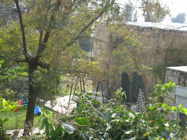
Bayt Naqquba / Naqquba
About the depopulated village of Bayt Naqquba / Naqquba
- District
- Al-Quds (Jerusalem)
- Date Bayt Naqquba / Naqquba was occupied
- 01 April 1948
- Population in 1948
- 50
- Military operation
- Operation Nachshon
- Brigade that carried it out
- Palmach
- Who defended the village
- Arab Liberation Army volunteers and some local Palestinian militia.
- Distance from the governorate centre
- 9.5 (km) West of Jerusalem
- Elevation above sea level
- 660 m
- Cause of displacement
- Military assault by Zionist troops
- Extent of destruction
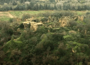
- Bayt Naqquba was mostly destroyed with the exception of a few houses remain standing.
- Ethnic cleansing
- Bayt Naqquba inhabitants were completely ethnically cleansed.
Hover a dot to read the village name, or click to open its card.
Borders of the depopulated village of Bayt Naqquba / Naqquba
Bayt Naqquba / Naqquba – Depopulated Palestinian Village of Jerusalem
Bayt Naqquba was a Palestinian village in the Jerusalem Subdistrict, sometimes shortened in later references to Naqquba. It stood on an elongated hill running north-south, surrounded by wadis on nearly every side except the north, and faced Suba to the south.
PalQuest places Bayt Naqquba approximately 9.5 kilometers west of Jerusalem at an average elevation of 660 meters above sea level. The Palestine Encyclopedia gives approximately 13 kilometers northwest of Jerusalem and an elevation of about 675 meters, reflecting a difference in measurement.
The village had 240 inhabitants in the official 1944/45 statistics and a total land area of 2,979 dunums. Its residents cultivated cereals, olives, and grapevines and used local springs for drinking water and irrigation.
Bayt Naqquba was occupied in early April 1948 during Operation Nachshon, the Haganah offensive designed to secure the road between the coastal plain and Jerusalem. No exact village-level occupation date or directly identified battalion is securely documented in Khalidi's account.
Basic Information
| Field | Information |
|---|---|
| Name | Bayt Naqquba |
| Short form | Naqquba |
| Arabic name | بيت نقوبا |
| Subdistrict | Jerusalem |
| Location | West of Jerusalem, north of the Jerusalem-Jaffa highway |
| Distance from Jerusalem | 9.5 km according to PalQuest; approximately 13 km in the Palestine Encyclopedia |
| Average elevation | 660 m according to PalQuest |
| Population in 1922 | 120, all Muslims |
| Population in 1931 | 177, all Muslims |
| Houses in 1931 | 41 |
| Population in 1944/45 | 240 |
| 1948 population estimate | 278 – later estimate, not an official census |
| Total land area | 2,979 dunums |
| Occupation date | Early April 1948; no exact securely documented day |
| Military operation | Operation Nachshon |
| Military force | Haganah/Palmach in the Operation Nachshon context; no village-specific battalion securely documented |
| Cause of depopulation | Depopulation during military assault and occupation; the precise circumstances of the villagers' departure are incompletely documented |
| Destruction | Most of the village was destroyed, while several stone houses survived |
| Post-1948 settlement | Beit Nekofa, established on what remained of the village in 1949 |
| Later Arab village | Ein Naqquba, established south of the old site in 1962 and inhabited partly by refugees from the original village |
Bayt Naqquba or Naqquba?
The village is documented by Walid Khalidi, PalQuest, and the Palestine Encyclopedia as Bayt Naqquba.
Naqquba is sometimes used as a shortened form, but the principal Palestinian sources reviewed do not establish a second, separately documented depopulated Jerusalem village by that name.
One secondary webpage titled “Naqquba” combines the geography of 'Aqqur with Bayt Naqquba's population figures and a different military date. It should therefore not be used as the basis for a separate village entry.
Location and Geography
Bayt Naqquba stood on an elongated north-south hill surrounded by wadis on nearly every side except the north.
Suba faced it to the south, and the village stood north of the main Jerusalem-Jaffa highway.
Secondary roads connected it with Bayt Surik, al-Qastal, Abu Ghosh, Suba, and Khirbat al-'Umur.
The Palestine Encyclopedia places the village on the southern base of Jabal Batin al-Sayyida, whose summit rises to approximately 880 meters.
Wadi al-Kharab, the upper course of Wadi Kasla, passed east of the village, while Wadi Bayt Naqquba flowed southward on the western side.
Built Environment
The village had a rectangular plan and expanded primarily from north to south.
Most houses were built of stone, and a small number of shops served the population.
The Palestinian built-up area covered approximately nine dunums in the 1944/45 statistics.
The 1931 census recorded forty-one houses.
Population
- 1922120Official census; all Muslims
- 1931177Official census; 41 houses
- 1944/45240Official Mandate-period figure
- 1948278Later demographic estimate, not an official census
- 19981,710Later Palestine Remembered estimate of refugees and descendants
Land Ownership, 1944/45
- Palestinian / official “Arab” category1,958 dunums66%
- Transferred to Zionists / official “Jewish” category951 dunums32%
- Public70 dunums2%
The figures balance exactly: 1,958 + 951 + 70 = 2,979 dunums.
Land Use, 1944/45
- Palestinian
- Jewish Category
- Public
- Cereals753 dunums
- Plantations and irrigable land334 dunums
- Built-up area305 dunums
- Non-cultivable land1,587 dunums
The land-use totals reconcile exactly with the full statistical land area.
Olive Groves and Double Counting
Olive trees covered approximately 194 dunums.
This acreage formed part of the 303 Palestinian dunums classified as plantations and irrigable land and should not be added again to the land-use total.
Economy and Agriculture
The villagers depended on agriculture, particularly cereals, olives, and grapevines.
Olive groves and vineyards were concentrated mainly west of the village and on the valley floors.
Local springs were used to irrigate these crops, while other fields depended on rainfall.
Water
A spring on the eastern edge of the village supplied drinking water.
The Palestine Encyclopedia identifies this spring as 'Ayn al-Masi.
Other local springs were used to irrigate olive groves, grapevines, and crops on the valley floors.
Education and Services
Khalidi and PalQuest do not document an independent village school at Bayt Naqquba before the Nakba.
A small number of shops served the community.
No pupil or teacher figures are therefore introduced without direct evidence.
Religious Buildings
The villagers were Muslims in the Mandate-period censuses.
The principal Khalidi/PalQuest village profile does not independently document a specific mosque or shrine.
No religious building is therefore asserted solely on the basis of the inhabitants' religious affiliation.
Archaeological Sites
Several khirbas stood near the village.
Khalidi records Khirbat al-Khanazir and Khirbat al-Ra's.
The Palestine Encyclopedia instead names Khirbat al-Maran and Khirbat al-Ra's.
Because the first name differs between the two Palestinian sources, this article preserves both source-specific forms rather than assuming they refer to the same site without further evidence.
Operation Nachshon
Operation Nachshon ran from 3 to 15 April 1948.
It was the first large-scale offensive within the framework of Plan Dalet aimed at opening and securing the Tel Aviv-Jerusalem road.
Approximately 1,500 Palmach and Haganah troops were mobilized in three battalions, while PalQuest lists Har'el and Giv'ati among the formations involved.
Bayt Naqquba is explicitly listed among the villages affected by the operation.
Occupation of Bayt Naqquba
No precise day of occupation is securely documented in Khalidi's account.
He states that Bayt Naqquba was occupied in early April 1948.
Given its location between al-Qastal and Qalunya, Khalidi suggests that the village was probably taken around the same period that those neighboring villages were occupied.
The frequently displayed 1 April date should therefore not be treated as a firm Operation Nachshon capture date, since the operation formally began on 3 April.
Military Unit
The military force documented at the operational level was the Haganah and Palmach within Operation Nachshon, which involved Har'el and Giv'ati formations.
Khalidi does not identify a specific brigade or battalion as the village-level force that directly entered Bayt Naqquba.
The most accurate formulation is therefore: Haganah/Palmach during Operation Nachshon; no village-specific battalion is securely documented.
Cause of Depopulation
Palestine Remembered classifies the cause as direct military assault.
Khalidi emphasizes that available information about the village's capture is limited and does not provide a detailed narrative of the inhabitants' departure.
The most cautious formulation is: depopulation in the course of military assault and occupation during Operation Nachshon; the precise village-level mechanism of flight or expulsion is incompletely documented.
Destruction
Most of Bayt Naqquba's built environment was destroyed after its occupation.
Several stone houses nevertheless survived, so the village should not be described as physically erased in its entirety.
Stones taken from ruined Palestinian houses were later reused as entrance steps in newer buildings.
Ethnic Cleansing in Source Classification
Palestine Remembered classifies Bayt Naqquba using the term “complete ethnic cleansing.” The phrase is retained here only as an attributed source classification.
The more specifically documented sequence is the village's occupation in early April 1948 during Operation Nachshon, the disappearance of its Palestinian community from the old site, destruction of most houses, and absence of permanent collective return to the original village.
Occupation Chronology
| Date | Event |
|---|---|
| 3 April 1948 | Operation Nachshon begins to open and secure the Tel Aviv-Jerusalem road. |
| Early April 1948 | Bayt Naqquba is occupied; Khalidi does not provide a precise day. |
| 8–9 April 1948 | Major fighting takes place at nearby al-Qastal. |
| 11 April 1948 | Haganah forces attack and heavily destroy nearby Qalunya. |
| 15 April 1948 | Operation Nachshon formally ends. |
| Later period | Most of Bayt Naqquba is demolished, while several stone houses survive. |
| 1949 | Beit Nekofa is established on what remained of the Palestinian village. |
| 1962 | A new Arab community is established south of the old site, later known as Ein Naqquba, and some refugees from the original village are allowed to settle there. |
Israeli Settlements Established on Bayt Naqquba's Lands
Beit Nekofa was established in 1949 on what remained of Bayt Naqquba.
It is the post-1948 settlement directly identified by Khalidi and PalQuest on the old village site.
Bayt Naqquba and Ein Naqquba after the Nakba
Bayt Naqquba represents an unusual post-Nakba case.
In 1962, a new Arab village was established south of the original site, and some refugees from old Bayt Naqquba were permitted to settle there.
This later Arab village is known today as Ein Naqquba.
The three localities should therefore be distinguished: depopulated Palestinian Bayt Naqquba, Beit Nekofa established in 1949, and the later Arab village of Ein Naqquba.
Bayt Naqquba Today
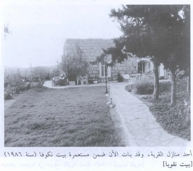
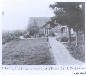
According to the field description used by Walid Khalidi before the publication of All That Remains in 1992, several stone houses survived at the former village site.
Some were used as residences and others as animal stables, and many had domed roofs.
Stones recovered from ruined village houses were reused as entrance steps in newer homes.
Almond and olive trees and cactus plants covered parts of the site.
The old village cemetery lay approximately half a kilometer south of the site and was maintained by residents of the later Arab village.
This description represents historical field documentation from before 1992 rather than a comprehensive archaeological or cadastral survey of the entire Bayt Naqquba area in 2026.
Sources
- PalQuest – Interactive Encyclopedia of the Palestine Question: Bayt Naqquba
- PalQuest – Operation Nachshon
- Palestine Remembered – Bayt Naqquba, Jerusalem Subdistrict
- Palestine Remembered – Bayt Naqquba entry from Walid Khalidi's All That Remains
- Palestine Encyclopedia – Bayt Naqquba
- Palestinian Villages Encyclopedia – Bayt Naqquba / Naqquba / Ein Naqquba
Photo gallery

Photos from the village's people
Photos sent in by visitors and published after review.
Add a photo of this village
Log in to add photos of this village.
Other villages from Al-Quds (Jerusalem)
More from the archive
 Al-Quds (Jerusalem)
The depopulated village of Khirbat al-Tannur - Allar al-Sifla / District of Al-Quds (Jerusalem)
 Al-Quds (Jerusalem)
The depopulated village of Jarash / District of Al-Quds (Jerusalem)
 Al-Quds (Jerusalem)
The depopulated village of al-Burayj (Bayarat Burayj) / District of Al-Quds (Jerusalem)
 Download Our Palestine App
The whole archive in the palm of your hand: depopulated villages, the Nakba, the massacres and Al-Aqsa — free, with no ads to erase the story.
Download Our Palestine App
The whole archive in the palm of your hand: depopulated villages, the Nakba, the massacres and Al-Aqsa — free, with no ads to erase the story.



Comments
No comments yet — be the first to write one.
Add your comment
Name and email are optional. Comments appear after review.