
The depopulated village of Al-Jammama / District of Bir-a-Saba (Beer Sheva)
About the depopulated village of Al-Jammama
- District
- Bir-a-Saba (Beer Sheva)
- Date Al-Jammama was occupied
- 22 May 1948
- Distance from the governorate centre
- 30 (km) West of Beersheba
- Elevation above sea level
- 150 m
- Extent of destruction
- al-Jammama was completely destroyed, and only house walls and rubble left behind.
- Ethnic cleansing
- al-Jammama inhabitants were completely ethnically cleansed.
Hover a dot to read the village name, or click to open its card.
Borders of the depopulated village of Al-Jammama
Al-Jammama – Depopulated Palestinian Village of the Beersheba Subdistrict
Al-Jammama was a Palestinian village in the Beersheba Subdistrict, situated in the northern Naqab on the edge of Wadi al-Mudabba', approximately 30 kilometers northwest of Beersheba and at an average elevation of about 150 meters above sea level.
The village was associated with the Arab al-'Atawina Bedouin community, part of which became permanently settled at al-Jammama before the Nakba. By the final years of the British Mandate, al-Jammama had developed beyond a seasonal encampment into a settled locality containing stone-and-mud buildings, shops, an elementary school, agriculture, and livestock raising.
- Subdistrict
- Beersheba
- Mandate District
- Gaza
- Location
- Northern Naqab, on the edge of Wadi al-Mudabba'
- Distance from Beersheba
- Approximately 30 km northwest/west
- Average Elevation
- Approximately 150 meters
- Population in 1931
- 6 people in one house according to the official census; the figure does not adequately represent the later growth of Arab al-'Atawina settlement at the site
- Population in 1945
- No independent figure in the 1945 Village Statistics
- Population near 1948
- 46 in Salman Abu Sitta's later estimate; a contemporary intelligence report reproduced by PalQuest gives 150 as the population in “normal times”
- Buildings before the Nakba
- Approximately 120 bakiyas according to information collected from Arab al-'Atawina
- Land Area
- No independently documented total in the 1945 Village Statistics
- Occupation and Depopulation Date
- 22 May 1948
- Military Operation
- Operation Barak, during its extended southern/second phase after mid-May
- Military Unit
- The Negev Brigade is the unit inferred by Khalidi as most likely responsible, operating in coordination with the Giv'ati Brigade during Operation Barak
- Cause of Displacement
- Military assault and evacuation of the village center; a contemporary report noted that residents remained in the surrounding area because they were semi-Bedouin
- Extent of Destruction
- Most of the built-up locality was destroyed; some walls remained, but no reliable numerical destruction percentage exists
- Settlement on Village Land
- Ruhama – already established on village land in 1944, before the Nakba
Location
Al-Jammama stood on rolling terrain in the northern Naqab on the edge of Wadi al-Mudabba'.
A secondary road connected it with Burayr to the northwest, which in turn linked to the Gaza road running parallel to the coastal highway.
A wider network of local roads also connected al-Jammama with the Beersheba–Gaza road, giving the locality an important position as a gateway into southern Palestine.
Al-Jammama during the First World War
Al-Jammama's strategic location had military significance decades before the Nakba.
On 8 November 1917, during the First World War, British forces defeated an Ottoman force in the al-Jammama area, bringing the locality under British control during the advance through southern Palestine.
Arab al-'Atawina and Settlement at al-Jammama
The village inhabitants were associated with Arab al-'Atawina.
Information collected by the Galilee Center for Social Research from members of al-'Atawina indicates that families settled at Khirbat al-Jammama and its surroundings before 1948.
The village's buildings, agriculture, shops, and school demonstrate a gradual transition toward permanent settlement.
The Bakiyas
Members of Arab al-'Atawina described approximately 120 buildings known as bakiyas at al-Jammama.
They were constructed of stone and mud and roofed with mud and timber.
The buildings on the main site were clustered relatively close together, with several shops in the center.
Many bakiyas served as family dwellings, while deteriorated structures were used for grain storage and animal shelters.
Population in 1931
The official 1931 Census of Palestine recorded only six inhabitants in one occupied house at al-Jammama.
This figure requires considerable caution. Walid Khalidi notes that the later report of approximately 120 bakiyas implies either that the 1931 figure substantially understated settlement at the locality or that permanent settlement expanded rapidly after the census.
The six-person total should therefore not be used as a description of al-Jammama's population immediately before the Nakba.
The 1945 Village Statistics
The 1945 Village Statistics list Jammama by name in the Beersheba Subdistrict but provide no separate population or total land-area figure.
This reflects the special statistical circumstances of the Beersheba region, where large parts of the Bedouin population and land were recorded through broader tribal categories.
No independent Palestinian / Transferred to Zionists / Communal-Public land-ownership table can therefore be constructed for al-Jammama from the 1945 statistics.
Population near the Nakba and the Source Discrepancy
The available sources give significantly different figures for al-Jammama immediately before depopulation.
| Source / Period | Figure | Qualification |
|---|---|---|
| 1931 Census | 6 | Official figure for one occupied house, predating the later expansion of permanent settlement |
| 1945 Village Statistics | Not available | The locality is listed but its population field is blank |
| Salman Abu Sitta – 1948 estimate | 46 | Later demographic estimate, not an official census |
| Intelligence report dated 30 June 1948 | 150 | Described as the population in “normal times” |
Neither 46 nor 150 should be presented as an undisputed official 1948 census figure.
The semi-Bedouin character of the community and movement between permanent buildings and surrounding grazing areas likely contributed to the statistical differences.
Economic Life
Al-Jammama's economy was principally agricultural.
The inhabitants cultivated:
- Wheat.
- Barley.
- Vegetables.
Animal husbandry was also important, supported by extensive surrounding pasture.
No reliable independent acreage table survives for each crop.
Water
Wells near the village supplied water for livestock and were also used to irrigate small vegetable plots.
The archaeological site additionally contained older water cisterns.
Shops and Local Commerce
Several shops stood among the clustered buildings in the village center.
Their presence reflects al-Jammama's role as a service point for its settled inhabitants and surrounding Bedouin communities, aided by road connections toward Burayr, Gaza, and Beersheba.
Education
An elementary school was established in al-Jammama in 1944.
Together with permanent buildings and shops, the school provides strong evidence of the locality's increasing permanence during the final years of the Mandate.
Archaeological Site
Al-Jammama was also an archaeological site containing:
- Water cisterns.
- An olive press.
- Mosaic floors.
- Tombs.
- A stone column capital.
- Fragments of stone columns.
Middle Paleolithic stone tools were also discovered in the surrounding area.
Operation Barak
The depopulation of al-Jammama was associated with Operation Barak on the southern front in May 1948.
The first phase began on 9 May and was led primarily by the Haganah's Giv'ati Brigade, while the Palmach's Negev Brigade participated from the south.
Following the end of the British Mandate on 15 May, a second phase continued in southern Palestine, and further villages were occupied through the end of the month.
PalQuest explicitly includes al-Jammama among the localities affected by Operation Barak.
Occupation and Depopulation
Walid Khalidi gives 22 May 1948 as the date on which al-Jammama was occupied and depopulated following a military assault.
A contemporary intelligence report later reproduced by PalQuest independently records the same evacuation date and attributes the evacuation to military action.
The report adds an important qualification: although the village was fully evacuated, its residents remained in their general area because they were semi-Bedouin.
The depopulation of the village center should therefore be distinguished from an assumption that every member of Arab al-'Atawina was immediately removed to a distant destination on the same day.
Military Unit
Khalidi infers from the military sequence that the Negev Brigade was most likely the unit that captured al-Jammama while advancing northward, in coordination with the Giv'ati Brigade during Operation Barak.
Because the source itself presents this as an inference, Giv'ati's participation in the wider operation should not automatically be converted into a claim that Giv'ati units directly entered al-Jammama.
The most accurate formulation is:
Probable executing unit: Negev Brigade, within Operation Barak and in operational coordination with the Giv'ati Brigade.
Occupation and Displacement Chronology
- Until 1948
Pre-Nakba Village
A settled Arab al-'Atawina locality with approximately 120 bakiyas, shops, an elementary school, farming, and livestock raising.
- 9 May 1948
Beginning of Operation Barak
The Giv'ati Brigade began the main offensive, with the Negev Brigade also participating from the south.
- After 15 May 1948
Second / Extended Phase
Military operations continued after the British withdrawal and the end of the Mandate.
- 22 May 1948
Occupation and Depopulation of al-Jammama
The village center was evacuated following military action; a contemporary report noted that the semi-Bedouin inhabitants remained within the broader area.
- Late May 1948
End-of-May Expansion
The participating brigades had by then taken control of numerous villages across the southern front.
Cause of Displacement
The documented immediate cause of al-Jammama's depopulation was military assault.
Both Khalidi's account and the contemporary report place the evacuation of the village center on 22 May 1948.
The report's statement that residents remained in their surrounding area because of their semi-Bedouin way of life requires a distinction between complete evacuation of the built-up village center and immediate long-distance removal of every member of the community.
Extent of Destruction
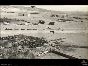
Most of al-Jammama's built environment was destroyed.
In the historical field description, only some walls remained on the slopes of the hills.
No reliable numerical destruction percentage is available, so an unsupported figure such as 90 or 100 percent is not used.
Ruhama and al-Jammama Land
Walid Khalidi records that the agricultural settlement of Ruhama was already established on al-Jammama land in 1944.
Ruhama therefore should not be described as a settlement first established after al-Jammama's 1948 depopulation.
- Settlement already present on village land before 1948: Ruhama – 1944.
- Separate post-1948 settlement documented by the principal source: none identified.
Al-Jammama Today
The available description of the village site derives from the historical field research incorporated into Walid Khalidi's All That Remains and should not be treated as direct 2026 field verification.
At the time of that documentation, a few walls remained on the slopes of the hills amid shrubs and thorns, while cactuses and trees grew across the site.
The village site was used for grazing and the surrounding lands for agriculture.
The source also recorded Bedouin families periodically pitching tents near the site to make use of nearby pasture.
Sources
- PalQuest – Interactive Encyclopedia of the Palestine Question: al-Jammama
- PalQuest – Operation Barak
- PalQuest – Intelligence Report on the Depopulation of Palestine, 30 June 1948: Jammama
- Institute for Palestine Studies – Walid Khalidi, All That Remains
- Palestine Remembered – al-Jammama entry from All That Remains
- Village Statistics 1945 – Beersheba Subdistrict: Jammama
- Salman Abu Sitta – Register of Depopulated Palestinian Localities: Jammama
- Government of Palestine – Census of Palestine, 1931
Photos from the village's people
Photos sent in by visitors and published after review.
Add a photo of this village
Log in to add photos of this village.
Other villages from Bir-a-Saba (Beer Sheva)
More from the archive
 Bir-a-Saba (Beer Sheva)
The depopulated village of Asluj / District of Bir-a-Saba (Beer Sheva)
Bir-a-Saba (Beer Sheva)The depopulated village of Dhulam Abu Juwayid / Tayaha / District of Bir-a-Saba (Beer Sheva)
Bir-a-Saba (Beer Sheva)The depopulated village of Sawakhneh / al-Azazmeh / District of Bir-a-Saba (Beer Sheva)
 Download Our Palestine App
The whole archive in the palm of your hand: depopulated villages, the Nakba, the massacres and Al-Aqsa — free, with no ads to erase the story.
Download Our Palestine App
The whole archive in the palm of your hand: depopulated villages, the Nakba, the massacres and Al-Aqsa — free, with no ads to erase the story.



Comments
No comments yet — be the first to write one.
Add your comment
Name and email are optional. Comments appear after review.