
The depopulated village of Al-Khalasa / District of Bir-a-Saba (Beer Sheva)
About the depopulated village of Al-Khalasa
- District
- Bir-a-Saba (Beer Sheva)
- Who defended the village
- Egyptian Army and Local volunteers.
- Elevation above sea level
- 225 m
- Extent of destruction
- The village was completely destroyed with the exception of few deserted and partially destroyed houses.
- Ethnic cleansing
- al-Khalasa inhabitants were completely ethnically cleansed.
Hover a dot to read the village name, or click to open its card.
Al-Khalasa – Depopulated Palestinian Village of the Beersheba Subdistrict
Al-Khalasa was a Palestinian village in the Beersheba Subdistrict, approximately 23 kilometers southwest of Beersheba. It stood at the confluence of Wadi al-Awsaja and Wadi al-Khalasa, at an average elevation of about 225 meters above sea level.
Unlike many of the dispersed Bedouin communities of the Beersheba region, al-Khalasa developed into a relatively settled village in the early twentieth century after members of the al-Azazmeh tribe established permanent houses there. The modern Palestinian village stood on the site of the ancient city of Elusa, associated with the Nabataean, Roman, Byzantine, and early Islamic history of the Naqab.
- Subdistrict
- Beersheba
- Mandate District
- Gaza
- Distance from Beersheba
- Approximately 23 km southwest
- Average Elevation
- Approximately 225 meters
- Location
- At the confluence of Wadi al-Awsaja and Wadi al-Khalasa amid bare mounds overlooking the surrounding countryside
- Population in 1931
- No independently documented village-specific figure; local al-Azazmeh inhabitants were largely enumerated through tribal categories
- Population in 1944/1945
- No independent figure is provided in Walid Khalidi's statistical entry
- Estimated Population in 1948
- No reliable independent estimate established; the frequently repeated figure of 46 is not used
- Land Area
- No independently documented 1944/45 land total in Khalidi's entry
- Occupation / Depopulation Date
- Not precisely established; final occupation was possibly in autumn 1948 during Operation Yoav
- Military Operation
- Operation Yoav is the strongest documented operational context, although the exact final capture date remains uncertain
- Military Unit
- Not conclusively established; a secondary Palestinian source attributes the capture to the Negev Brigade
- Post-1948 Settlements
- No Israeli settlements are documented on al-Khalasa village land in Khalidi/PalQuest
Location
Al-Khalasa stood amid bare mounds and overlooked wide expanses of the surrounding country in most directions except toward the south.
The village occupied the meeting point of Wadi al-Awsaja and Wadi al-Khalasa, a geographically important location on routes connecting the Beersheba region, the Naqab, Gaza, and historically Petra.
Its average elevation was approximately 225 meters, and it lay about 23 kilometers southwest of Beersheba.
Al-Khalasa and Ancient Elusa
The modern Palestinian village occupied one of the major archaeological sites of the Naqab.
Edward Robinson identified the site in 1838 with ancient Elusa, a city associated with Nabataean, Roman, and Byzantine history.
Elusa stood on the caravan route linking Petra with Gaza and appears on the sixth-century Madaba mosaic map.
It appears to have served an important administrative role in the Byzantine province of Palaestina Tertia.
The town also continued to appear in medieval Islamic geographical writing. Al-Dimashqi described it as a town within the administrative orbit of Gaza, while al-Maqrizi referred to it as one of the larger cities of southern Palestine.
Its importance declined as the old trade routes across the Naqab lost their earlier commercial role.
Resettlement in the Early Twentieth Century
Renewed archaeological interest in al-Khalasa during the early twentieth century coincided with the settlement there of members of the al-Azazmeh Bedouin tribe.
They constructed a roughly triangular village between the two wadis, with houses built of stone and mud.
Al-Khalasa therefore provides an important example of the transition from dispersed Bedouin encampment life toward permanent village settlement in the Beersheba region.
Population and Tribal Affiliation
The inhabitants were principally associated with al-Azazmeh. Later Palestinian community documentation also mentions the Abu 'Adhra family among the village residents.
No reliable independent village population should be invented for al-Khalasa, however. Walid Khalidi's statistical entry gives no figure for either 1931 or 1944/45.
This reflects the distinctive demographic record of the Beersheba Subdistrict, where much of the Bedouin population was enumerated by tribe rather than by every individual encampment or newly settled locality.
Population
| Year | Population | Note |
|---|---|---|
| 1931 | Not independently available | Khalidi records the figure as unavailable; the inhabitants were not statistically separated from the surrounding tribal enumeration in a way that yields a secure village total |
| 1944/1945 | Not independently available | No separate population figure appears in the statistical entry used by All That Remains |
| 1948 | Not established | The frequently repeated figure of 46 is not accepted because it is unsupported by the principal village source |
Why the Figure of 46 Is Not Used
Some modern online lists reproduce “46 inhabitants” for al-Khalasa and several other Beersheba localities.
Walid Khalidi's village entry, however, explicitly provides no population figure for al-Khalasa in either 1931 or 1944/45.
The repeated appearance of 46 beside several unrelated Beersheba sites further makes it unsuitable as a village-specific demographic figure.
This article therefore leaves the population unknown rather than filling the gap with an unsupported number.
Land and Property
Khalidi's 1944/45 statistical entry does not provide an independent al-Khalasa land-ownership or land-use total.
A standard Palestinian / Transferred to Zionists / Communal-Public table therefore cannot be constructed reliably for the village.
Nor should the immense wider al-Azazmeh tribal territory be treated as the land area of al-Khalasa itself.
Economic Life
Al-Khalasa's inhabitants relied principally on animal husbandry and commerce.
The development of a number of shops reflected the village's increasing permanence and its role within the movement and trade networks of the Beersheba and central Naqab region.
No independent table of crop acreage, orchards, or livestock belonging specifically to al-Khalasa has been established from the principal sources.
Water
The villagers obtained drinking water from a local spring according to Khalidi's description.
A large well also remained visible at the village site in the post-Nakba field description.
Education
An elementary school was established in al-Khalasa in 1941.
Together with the village shops and permanent stone-and-mud houses, the school illustrates the degree to which al-Khalasa had become a settled village rather than merely a seasonal encampment by the final years before the Nakba.
Archaeology
Archaeological work began at the site in the early twentieth century, and a British survey prepared a plan of the archaeological remains in 1914.
Excavations in 1938 uncovered remains of the ancient city, tombs, and inscribed architectural fragments.
Further excavations between 1973 and 1980 revealed remains including a large Nabataean theater, major ecclesiastical structures, defensive towers, and ancient houses.
These archaeological remains should be distinguished from the buildings of the modern Palestinian village established by al-Azazmeh.
Occupation and Depopulation
The principal historical source does not establish one definitive occupation date for al-Khalasa.
Walid Khalidi cites a postwar statement attributed to the commander of the Negev Brigade claiming that the Naqab had come under Zionist control by 15 May 1948, which raises the possibility of relatively early control over the area.
Khalidi nevertheless presents another possibility: that al-Khalasa, like Beersheba, may have remained outside final Israeli control until October 1948 and Operation Yoav.
The article therefore does not present 15 May or any other single day as conclusively established without qualification.
Operation Yoav
Operation Yoav provides the clearest documented military context for the village's possible final occupation.
The operation began on 15 October 1948 and ended on 4 November 1948. Its purpose was to break Egyptian lines in southern Palestine and connect Israeli forces in the Naqab with forces farther north.
PalQuest explicitly includes al-Khalasa among the localities affected by Operation Yoav.
The Giv'ati, Yiftach, Negev, and Har'el brigades took part in the operation as a whole.
Military Unit
The specific unit that occupied al-Khalasa cannot be identified conclusively from the principal sources used here.
Palestine Remembered's statistical summary attributes the capture to the Negev Brigade during Operation Yoav and lists Egyptian forces and local volunteers among the defenders.
Khalidi's own narrative, however, does not definitively identify a brigade as the executing force.
The most accurate formulation is therefore: the Negev Brigade is attributed in a secondary Palestinian source, but the village-specific attacking unit remains uncertain.
Occupation and Displacement Chronology
- Until 1948
Prewar Village
A relatively settled al-Azazmeh village with stone-and-mud houses, a school, and shops.
- By 15 May 1948
Possible Early Control
Khalidi records a broad postwar military claim concerning control of the Naqab, but this does not conclusively prove that al-Khalasa itself was occupied on that date.
- Summer 1948
Possible Continued Palestinian Presence
The principal source leaves open the possibility that the village remained outside final Israeli control through the summer.
- 15 October 1948
Beginning of Operation Yoav
A large Israeli offensive began against Egyptian positions in southern Palestine.
- October 1948
Probable Final Occupation
Khalidi considers it possible that al-Khalasa held out until Operation Yoav, and PalQuest includes it among the operation's affected localities.
- 4 November 1948
End of Operation Yoav
By this stage military control across the Beersheba region had been fundamentally transformed.
Cause of Displacement
The depopulation of al-Khalasa occurred in the context of the military conquest of the Naqab during the 1948 war.
The principal sources do not provide a detailed family-by-family account or one independently established expulsion event on a precise date.
The most supportable description is therefore that the inhabitants were displaced in the course of military operations and the change of control in the Naqab, with the final phase possibly connected to Operation Yoav in autumn 1948.
Extent of Destruction
Al-Khalasa was not erased so completely that no structures survived.
Khalidi's postwar field description records a number of village houses still standing but abandoned and partially destroyed, together with substantial rubble from other houses.
No documented numerical destruction percentage exists, so this article does not use an unsupported figure such as “100 percent destroyed.”
Post-1948 Settlements
Walid Khalidi and PalQuest state that no Israeli settlements were established on al-Khalasa village lands.
The area was described as being used for military training.
Nearby settlements are therefore not listed as “settlements on village land” without direct cadastral evidence.
Al-Khalasa Today
The available description of al-Khalasa's present remains is based primarily on field research incorporated into Walid Khalidi's All That Remains, including documentation from around 1990. It should therefore be understood as a historical site description rather than a direct 2026 field verification.
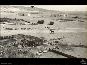
At the time of that documentation, several village houses were still standing but were deserted and partially ruined.
West of the village site stood a well with a circular mouth and metal ladder. Nearby was a large rectangular house containing eight rooms, with the rubble of approximately ten demolished houses behind it.
Remains of the cemetery were visible in the northern part of the site, near archaeological excavations and ruined village buildings. Approximately fifteen partially destroyed houses were recorded to the south and west.
The same historical source stated that no Israeli settlement had been built on the village lands and that the area was being used for military training.
Sources
- PalQuest – Interactive Encyclopedia of the Palestine Question: al-Khalasa
- PalQuest – Operation Yoav
- Institute for Palestine Studies – Walid Khalidi, All That Remains
- Palestine Remembered – al-Khalasa, Beersheba
- Palestine Remembered – al-Khalasa entry from All That Remains
- Encyclopedia of Palestinian Villages – al-Khalasa / Beersheba
- Palestine Land Society – Salman Abu Sitta, The Palestinian Nakba 1948, for the broader Beersheba demographic context
Photos from the village's people
Photos sent in by visitors and published after review.
Add a photo of this village
Log in to add photos of this village.
Other villages from Bir-a-Saba (Beer Sheva)
More from the archive
The depopulated village of Dhulam Abu Juwayid / Tayaha / District of Bir-a-Saba (Beer Sheva)
Bir-a-Saba (Beer Sheva)The depopulated village of Farahin / al-Azazmeh / District of Bir-a-Saba (Beer Sheva)
Bir-a-Saba (Beer Sheva)The depopulated village of Nuseirat / Hanajira / District of Bir-a-Saba (Beer Sheva)
 Download Our Palestine App
The whole archive in the palm of your hand: depopulated villages, the Nakba, the massacres and Al-Aqsa — free, with no ads to erase the story.
Download Our Palestine App
The whole archive in the palm of your hand: depopulated villages, the Nakba, the massacres and Al-Aqsa — free, with no ads to erase the story.



Comments
No comments yet — be the first to write one.
Add your comment
Name and email are optional. Comments appear after review.