
The depopulated village of al-Nabi Rubin (Aka) / District of Akka (Acre)
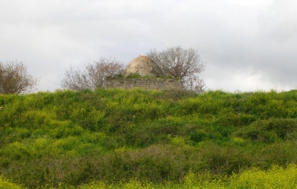
al-Nabi Rubin (Aka)
About the depopulated village of al-Nabi Rubin (Aka)
- District
- Akka (Acre)
- Date al-Nabi Rubin (Aka) was occupied
- 01 November 1948
- Population in 1948
- 1,000
- Military operation
- Operation Hiram
- Distance from the governorate centre
- 28 (km) Northeast of Acre
- Elevation above sea level
- 550 m
- Cause of displacement
- Expulsion by Zionist troops
- Extent of destruction
- al-Nabi Rubin was mostly destroyed with the exception of its shrine.
- Ethnic cleansing
- al-Nabi Rubin inhabitants were completely ethnically cleansed.
- Settlements built on the built-up area of al-Nabi Rubin (Aka) after 1948
- Even Menachem
Hover a dot to read the village name, or click to open its card.
Borders of the depopulated village of al-Nabi Rubin (Aka)
Al-Nabi Rubin – Depopulated Palestinian Village in Acre Subdistrict
Al-Nabi Rubin was a Palestinian village in the Acre subdistrict of Upper Galilee. It stood on a dome-shaped hill approximately 28 kilometers northeast of Acre, at an average elevation of about 550 meters above sea level, close to the Lebanese border.
The village was closely associated with Tarbikha, about one kilometer to the northwest, which provided many of the essential services used by Al-Nabi Rubin's inhabitants. The village contained a shrine dedicated to al-Nabi Rubin, from which it derived its name and which became the principal surviving structure after the destruction of the village.
The area came under Israeli control in the immediate aftermath of Operation Hiram at the end of October 1948. The final depopulation of Al-Nabi Rubin, however, occurred later: Walid Khalidi records that Israeli occupation forces ordered the villagers to cross the border into Lebanon during the second week of November 1948.
Key Facts about Al-Nabi Rubin
| Field | Information |
|---|---|
| Name | Al-Nabi Rubin |
| Subdistrict | Acre |
| Status | Depopulated Palestinian village |
| Distance from Acre | Approximately 28 km northeast of Acre |
| Average elevation | Approximately 550 m above sea level |
| Nearest associated village | Tarbikha, approximately 1 km northwest |
| Population, 1944/45 | 1,000 for the combined statistical unit of Al-Nabi Rubin, Tarbikha, and Suruh; not Al-Nabi Rubin alone |
| Land area, 1944/45 | 18,563 dunums for the combined statistical unit of Al-Nabi Rubin, Tarbikha, and Suruh |
| Military operation associated with the occupation | Operation Hiram, with the final expulsion occurring after the operation ended |
| Summary occupation date reported by Palestine Remembered | 1 November 1948 |
| Final expulsion | Second week of November 1948 |
| Unit that specifically entered Al-Nabi Rubin | Not independently identified in Khalidi/PalQuest's village entry |
| Cause of final depopulation | Direct expulsion and orders forcing residents across the border into Lebanon |
| Destruction | The village was largely destroyed; Khalidi's field account states that only the shrine remained |
Location of Al-Nabi Rubin
Al-Nabi Rubin stood in the northeastern part of the Acre subdistrict near the Lebanese border. Its dome-shaped hill rose approximately 30–40 meters above neighboring Tarbikha, located about one kilometer to the northwest.
The village belonged geographically to the highland environment of western Upper Galilee and was closely associated with Tarbikha, Suruh, Iqrit, Khirbat 'Iribbin, and Dayr al-Qasi.
The Name and Shrine of Al-Nabi Rubin
The village took its name from the shrine of al-Nabi Rubin located within it. It should not be confused with the other Palestinian village of the same name in the Ramla subdistrict, southwest of al-Ramla.
The shrine was the village's most prominent religious and architectural landmark and survived the destruction of most of Al-Nabi Rubin. The association of the shrine with a prophet named Rubin is part of the site's religious tradition and should not by itself be treated as archaeological proof of the identity of the person commemorated there.
Al-Nabi Rubin before the Nakba
The village stood on a dome-shaped hill and its population was predominantly Muslim. Tarbikha, the larger neighboring village, supplied essential services, making Al-Nabi Rubin closely dependent on and connected with Tarbikha in everyday social and economic life.
Most of the surrounding lands were used as pasture, although villagers also cultivated cereals, olives, and tobacco.
Population of Al-Nabi Rubin
The population figures require an important qualification. The official 1944/45 statistics did not record Al-Nabi Rubin separately from Tarbikha and Suruh; instead, all three were treated as a single statistical unit.
- 1944/451,000Official figure for Al-Nabi Rubin, Tarbikha, and Suruh combined; it is not the population of Al-Nabi Rubin alone
The figure of 1,000 should therefore never be described simply as “the population of Al-Nabi Rubin in 1945” without noting that it represents all three villages.
The principal sources reviewed do not provide a reliable separate official 1944/45 population figure for Al-Nabi Rubin alone. No independent number has therefore been reconstructed mathematically or estimated in this article.
Number of Houses
The principal sources reviewed do not provide a separately documented number of houses for Al-Nabi Rubin before the Nakba. Because several official statistics grouped Al-Nabi Rubin with Tarbikha and Suruh, no house total has been inferred from population figures or borrowed from a neighboring village.
Land Ownership of Al-Nabi Rubin, Tarbikha, and Suruh
The 1944/45 statistics treat the lands of Al-Nabi Rubin, Tarbikha, and Suruh as a combined statistical unit totaling 18,563 dunums. Using the ownership terminology presented by Palestine Remembered:
- Palestinian12,548 dunums34%
- Transferred to Zionists0 dunums0%
- Communal/Public6,015 dunums16%
- Correct Total18,563 dunums50%
12,548 + 0 + 6,015 = 18,563 dunums.
The Arabic Palestine Remembered page contains an apparent display error in its total row, where 6,015 appears instead of 18,563. The corrected total used here is confirmed both mathematically and by PalQuest's statistical table.
These figures apply to the three-village statistical unit and should not be treated as the separate land area of Al-Nabi Rubin alone.
Land Use in 1944/45
The following official land-use figures likewise apply to Al-Nabi Rubin, Tarbikha, and Suruh together:
- Arab
- Public
- Cereals3,204 dunums
- Plantations and irrigable land619 dunums
- Built-up area112 dunums
- Non-cultivable land14,628 dunums
The table is internally consistent: 3,204 + 619 + 112 + 14,628 = 18,563 dunums.
Economic Life in Al-Nabi Rubin
Pastoralism and livestock grazing formed an important part of Al-Nabi Rubin's economy, as much of the surrounding land was devoted to pasture. Villagers also cultivated cereals, olives, and tobacco.
The combined 1944/45 statistics for Al-Nabi Rubin, Tarbikha, and Suruh record 3,204 dunums devoted to cereals, including 3,200 Arab dunums and 4 Public dunums, while 619 dunums were classified as plantations or irrigable land.
These areas cannot be apportioned among the three villages without a reliable source that separates them. The article therefore does not assign a specific cereal or orchard acreage to Al-Nabi Rubin alone.
Education and Services
Al-Nabi Rubin relied heavily on neighboring Tarbikha for essential services. Palestine Remembered records that children from Al-Nabi Rubin attended the school in Tarbikha.
The principal sources reviewed do not establish the existence of an independent school within Al-Nabi Rubin itself. No separate school building, founding date, or enrollment figure has therefore been attributed to the village.
The Shrine of Al-Nabi Rubin
The shrine of al-Nabi Rubin was the village's principal landmark. It survived the destruction that followed the Nakba and was the only original village structure still standing in Walid Khalidi's field description.
Operation Hiram
Israeli occupation forces carried out Operation Hiram between 28 and 31 October 1948 in Upper Galilee. Units drawn from the Sheva' / Seventh, Carmeli, Golani, and 'Oded brigades participated on different fronts and at different stages of the operation.
During the operation, Israeli forces occupied large parts of Upper Galilee and reached villages along the Lebanese border. On 31 October, the 'Oded Brigade occupied several villages in the border sector, including Tarbikha, the village immediately northwest of Al-Nabi Rubin.
For Al-Nabi Rubin itself, however, the Khalidi/PalQuest village entry does not independently identify the brigade that specifically entered the village. It would therefore be inaccurate to assign the village automatically to 'Oded, Sheva', Carmeli, Golani, or any other brigade simply because those units participated in Operation Hiram or operated nearby.
Occupation and Depopulation of Al-Nabi Rubin
Palestine Remembered gives 1 November 1948 as the summary occupation date for Al-Nabi Rubin and associates the village with Operation Hiram, which had formally ended on 31 October.
This date, however, did not mark the end of the village's depopulation. Walid Khalidi records that inhabitants remained after the major military operations had ended, and that Al-Nabi Rubin was among the border villages emptied during the second week of November 1948.
Khalidi, citing Israeli historian Benny Morris, reports that Israeli occupation forces ordered the inhabitants of Al-Nabi Rubin to cross the border into Lebanon. A report dated 16 November from Northern Front commander Moshe Carmel to David Ben-Gurion specifically named Al-Nabi Rubin among the border villages whose inhabitants had been expelled on stated military grounds.
The military takeover in the immediate aftermath of Operation Hiram must therefore be distinguished from the later final expulsion of the villagers during the second week of November.
Palestine Remembered classifies the complete removal of the village community as ethnic cleansing. In directly documented descriptive terms, the residents were ordered across the Lebanese border after the main military operations had ended, leaving Al-Nabi Rubin completely depopulated of its Palestinian community.
Occupation Chronology
- 28–31 October 1948
Operation Hiram
A major military offensive in Upper Galilee involving several brigades on different fronts.
- 31 October 1948
Occupation of neighboring Tarbikha
Units of the 'Oded Brigade occupied Tarbikha and other villages in the Lebanese-border sector.
- 1 November 1948
Summary occupation date for Al-Nabi Rubin
This is the date reported by Palestine Remembered, immediately following the formal end of Operation Hiram.
- Early November 1948
Residents remain after major operations
Khalidi's account makes clear that final depopulation did not occur simply with the end of Operation Hiram.
- Second week of November 1948
Final expulsion
Israeli occupation forces ordered the inhabitants to cross the border into Lebanon.
- 16 November 1948
Military report documenting the expulsion
Northern Front commander Moshe Carmel explicitly named Al-Nabi Rubin in a report concerning the expulsion of inhabitants from border villages.
- Later; precise date not established in the principal sources reviewed
Destruction of the village
Most village structures were destroyed; Khalidi's later field description recorded the shrine as the sole surviving original structure.
Israeli Settlements and Al-Nabi Rubin's Lands
PalQuest and Walid Khalidi list four Israeli settlements in the section dealing with the village and post-1948 settlement, but the wording allows an important distinction between settlements explicitly described as being on village land and those described only as being near the site:
| Settlement | Established | Relationship to Al-Nabi Rubin |
|---|---|---|
| Shomera | 1949 | Established west of the village site; the sentence does not explicitly state that it lies within Al-Nabi Rubin's village lands |
| Even Menachem | 1960 | Located very close to the village site on a hill to the west; the sentence does not explicitly identify it as being on village land |
| Kefar Rosenwald / Zar'it | 1967 | Explicitly described by Khalidi as established on Al-Nabi Rubin's lands |
| Shetula | 1969 | Explicitly described as located on Al-Nabi Rubin's lands |
Al-Nabi Rubin Today
According to Walid Khalidi's field description, the shrine of al-Nabi Rubin was the only original village building that remained. Cactus plants, fig trees, and tall grasses covered the site, which had been converted into grazing land.
This description derives from field research undertaken before the publication of Khalidi's All That Remains in 1992. It therefore constitutes a documented historical description of the site at that time rather than a comprehensive direct field verification of conditions at Al-Nabi Rubin in 2026.
Sources
Photos from the village's people
Photos sent in by visitors and published after review.
Add a photo of this village
Log in to add photos of this village.
Other villages from Akka (Acre)


More from the archive


 Download Our Palestine App
The whole archive in the palm of your hand: depopulated villages, the Nakba, the massacres and Al-Aqsa — free, with no ads to erase the story.
Download Our Palestine App
The whole archive in the palm of your hand: depopulated villages, the Nakba, the massacres and Al-Aqsa — free, with no ads to erase the story.



Comments
No comments yet — be the first to write one.
Add your comment
Name and email are optional. Comments appear after review.