
The depopulated village of Qaqun / District of Tulkarm
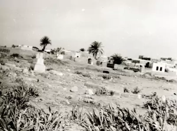
About the depopulated village of Qaqun
- District
- Tulkarm
- Date Qaqun was occupied
- 05 June 1948
- Population in 1948
- 2,285
- Brigade that carried it out
- Alexandroni Brigade
- Who defended the village
- Iraqi Army fought like men possessed. They fought to the last man in three defensive trench lines. Unconfirmed report claimed a whole battalion was obliterated (45 soldiers),
- Distance from the governorate centre
- 6 km northwest of Tulkarm
- Elevation above sea level
- 25 m
- Cause of displacement
- Direct military assault by Israeli occupation forces
- Extent of destruction
- Qaqun was mostly destroyed with the exception Qaqun's boys school.
- Ethnic cleansing
- Qaqun inhabitants were completely ethnically cleansed.
- Settlements built on the land of Qaqun before 1948
- Kibbutz ha-Ma'pil, built in 1945 on what had traditionally been village land, 3 km to the northwest
- Settlements built on the built-up area of Qaqun after 1948
- Gan Yoshiyya, Ometz and 'Olesh (1949), Channi'el (1950) and Yikkon (early 1950s, a transit camp for new Jewish immigrants later made into a regional school), all on village land
Hover a dot to read the village name, or click to open its card.
Borders of the depopulated village of Qaqun
Qaqun: A Depopulated Palestinian Village in the Tulkarm District
Qaqun was a depopulated Palestinian village in the Tulkarm District, located approximately 6 kilometers northwest of the city of Tulkarm. It stood on a hill overlooking the Qaqun Plain at an average elevation of about 25 meters above sea level.
- Subdistrict
- Tulkarm
- Distance from district center
- 6 km northwest of Tulkarm
- Average Elevation
- 25 m above sea level
- Population in 1931
- 1,367
- Number of Houses in 1931
- 260
- Population in 1944/1945
- 1,970
- Estimated Population in 1948
- About 2,285 – a later demographic estimate, not an official census
- Total Land Area in 1945
- 41,767 dunams
- Attack and Depopulation
- After an Irgun raid in March 1948 failed to penetrate the village, Israeli occupation forces, mainly the Third Battalion of the Alexandroni Brigade, attacked it on the night of 4–5 June 1948 with heavy mortar and artillery fire; Iraqi army units resisted from three lines of trenches until a violent attack in daylight decided the battle. Some of the village's inhabitants remained in their homes at least until July 1949.
- Final Israeli Control
- 5 June 1948, after an attack that began on the night of 4–5 June, according to the History of the War of Independence as cited by Khalidi
- Military Unit
- Mainly the Third Battalion of the Alexandroni Brigade, according to the History of the War of Independence as cited by Khalidi; the Irgun had raided the village in March 1948
- Cause of Depopulation
- Direct military assault by Israeli occupation forces
- Settlements Documented on Village Lands
- Kibbutz ha-Ma'pil, built in 1945 on what had traditionally been village land, 3 km to the northwest; and Gan Yoshiyya, Ometz and 'Olesh (1949), Channi'el (1950) and Yikkon (early 1950s, a transit camp for new Jewish immigrants later made into a regional school), all on village land
Qaqun was historically and agriculturally important. Secondary roads linked it with Tulkarm and neighboring villages, while the Tulkarm–Haifa railway passed approximately half a kilometer east of the village. During the Nakba and the occupation of Palestine in 1948, Israeli forces captured Qaqun on 5 June after a fierce battle with Iraqi army units. The principal attacking force was the Third Battalion of the Alexandroni Brigade.
Location of Qaqun
- Qaqun was located approximately 6 kilometers northwest of Tulkarm.
- Its average elevation was about 25 meters above sea level.
- The village stood on a hill overlooking the Qaqun Plain, with Tulkarm situated to its southeast.
- The Tulkarm–Haifa railway passed approximately half a kilometer east of the village.
- Secondary roads connected Qaqun with Tulkarm and neighboring Palestinian communities.
Qaqun Through History
Qaqun was an important historical site. During the Crusader period it was known by several names, including Quaquo, Chaco, and Caco, and was administratively associated with Caesarea.
In 1267, the Mamluk sultan Baybars captured Qaqun and ordered its fortress rebuilt. A church within the complex was renovated and converted into a mosque, the markets were re-established, and Qaqun subsequently became a commercial center with a khan serving merchants and travelers.
Under the Mamluks, Qaqun also served as a postal station on the Gaza–Damascus route.
In 1596, Qaqun was the center of the nahiya of Qaqun within the liwa' of Nablus and had an estimated population of 127. Its inhabitants paid taxes on wheat, barley, goats, beehives, and other products.
In 1799, Napoleon's forces defeated Ottoman troops sent to Qaqun to obstruct the French advance toward Acre. The village was again destroyed in the nineteenth century by the army of Ibrahim Pasha after inhabitants of the area participated in the revolt against Egyptian rule.
The Built Environment and Facilities of Qaqun
In the late nineteenth century, Qaqun was described as a large village built around the central tower of its Crusader-Mamluk fortress. Houses constructed of stone and mud were dispersed across the hill.
By the end of the British Mandate period, the inhabitants were Muslims. The village mosque stood near the main market, and residents relied on wells for drinking water.
An elementary school for boys was established in Qaqun during the British Mandate.
Land Ownership in Qaqun
The total land area recorded for Qaqun in the 1944/1945 statistics was 41,767 dunums.
The Arabic Palestine Remembered table uses the categories “Palestinian,” “Transferred to Zionists,” and “Masha'.” These terms are preserved below to reflect the terminology of that source. The Government of Palestine statistics, as reproduced by PalQuest, classify the corresponding categories as “Arab,” “Jewish,” and “Public.”
Land Ownership in Qaqun, 1944/1945, Using the Terminology of Palestine Remembered
- Palestinian35,611 dunums85%
- Transferred to Zionists4,642 dunums11%
- Masha' / Communal1,514 dunums4%
Land Use in Qaqun in 1944/1945
Official statistics show the extensive agricultural use of Qaqun's lands. A total of 37,809 dunums was devoted to cereals, consisting of 34,376 dunums of Arab land, 3,032 dunums of Jewish land, and 401 dunums of public land.
Citrus and bananas covered 2,289 dunums, consisting of 713 dunums of Arab land and 1,576 dunums of Jewish land. Plantations and irrigable land covered 243 dunums, including 210 dunums of Arab land and 33 dunums of Jewish land.
Land Use in Qaqun According to the 1944/1945 Statistics
- Arab
- Jewish
- Public
- Citrus and Bananas2,289 dunums
- Plantations and Irrigable Land243 dunums
- Cereals37,809 dunums
- Built-up Area144 dunums
- Non-Cultivable Land1,282 dunums
Eighty dunums of the Arab-owned plantations were planted with olive trees. This area formed part of the 210 dunums classified as plantations and irrigable land and should not be added again as a separate land-use category.
Economic Life in Qaqun
Agriculture was the principal basis of Qaqun's economy. The inhabitants cultivated cereals, watermelons, vegetables such as cucumbers, olives, citrus fruit, and bananas.
The 1944/1945 statistics show that cereals occupied the largest portion of cultivated land, while citrus, bananas, irrigated cultivation, and plantations formed another important sector of the village economy.
Population of Qaqun
The 1922 census recorded 1,629 inhabitants in Qaqun, including 29 Christians, with the remainder Muslims. In the 1931 census, the population was 1,367, all Muslims, living in 260 houses.
The Government of Palestine's 1944/1945 statistics recorded a population of 1,970.
The figures of 2,285 inhabitants for 1948 and 14,034 refugees for 1998 published by Palestine Remembered are later estimates and are not official Government of Palestine censuses.
Palestine Remembered's statistical table currently gives 1,367 for both 1922 and 1931. However, the 1922 figure conflicts with the official 1922 census and with the site's own historical account of Qaqun, both of which give a population of 1,629 for that year.
Population of Qaqun
- 1596127Historical estimate based on Ottoman records
- 19221,629Official census; 29 Christians and the remainder Muslims
- 19311,367Official census; all Muslims
- 1944/19451,970Government of Palestine statistics
- 19482,285Estimate published by Palestine Remembered
- 199814,034Estimated refugee population published by Palestine Remembered
Number of Houses in Qaqun
The 1931 census recorded 260 houses in Qaqun. The figure of 434 houses for 1948 published by Palestine Remembered is a later estimate rather than an official Government of Palestine census figure.
Number of Houses in Qaqun
- 1931260Official census
- 1948434Estimate published by Palestine Remembered
Education in Qaqun
An elementary school for boys was established in Qaqun during the British Mandate. Its building was among the principal village structures that survived the Nakba.
Archaeological and Historical Remains in Qaqun
Qaqun was an important archaeological and historical site. Its principal remains included the Crusader fortress later restored under the Mamluks, the Mamluk mosque, and architectural fragments from other structures.
The fortress was particularly associated with the Mamluk sultan Baybars, who captured Qaqun in 1267 and ordered it rebuilt. During the Mamluk period, the village also served as a postal station on the Gaza–Damascus route and as a commercial center for merchants and travelers.
The March 1948 Raid on Qaqun
Several months before its final occupation, Qaqun was subjected to a raid by the Irgun on 6 March 1948, according to Walid Khalidi, citing the History of the Haganah.
The Palestinian newspaper Filastin also reported an attack on the morning of 7 March. Citing a communiqué issued by Palestinian militia forces, the newspaper stated that a large attacking force failed to penetrate the village and threw grenades that wounded two women.
The raid did not result in Qaqun's occupation, and the village remained one of the last Palestinian communities still standing in this section of the coastal plain during the following weeks.
The Attack and Occupation of Qaqun on 5 June 1948
On 9 May 1948, Haganah intelligence officers met to discuss the fate of Qaqun and several other Palestinian villages on the coastal plain. Walid Khalidi, citing Israeli historian Benny Morris, states that a decision was taken to subdue or evacuate these communities. This information is included because it is cited by the Palestinian source Khalidi/PalQuest rather than through independent reliance on an Israeli source.
The plan was not immediately implemented at Qaqun. A few days before the first truce, Israeli forces instead launched an offensive specifically intended to capture the village.
The attack began during the night of 4–5 June 1948 with heavy mortar and artillery fire. The attacking force consisted primarily of the Third Battalion of the Alexandroni Brigade.
The attackers encountered strong resistance from Iraqi army units defending Qaqun's northern approaches from three lines of trenches and fortified positions. Fighting continued into daylight before the attacking forces gained control of the village on 5 June.
The New York Times described the battle as one of the bloodiest fought up to that point and reported intense close-range fighting between the two sides.
Accounts of Iraqi casualties differ substantially. The official Israeli account cited by Khalidi claimed that an Iraqi force of approximately 450 men was wiped out, while Palestine Remembered describes a separate figure of 45 soldiers as an unconfirmed report. Neither figure is therefore presented here as a verified final casualty count.
Name of the Military Operation
Walid Khalidi's account and the PalQuest entry do not provide a separate formal operation name for the attack that captured Qaqun. They describe it as an offensive launched specifically to seize the village, carried out primarily by the Third Battalion of the Alexandroni Brigade.
Palestine Remembered, however, classifies the capture of Qaqun under an operation it calls “Coastal Clearing.” Because Khalidi and PalQuest do not use this name for the Qaqun attack, it is presented here as the designation used by Palestine Remembered rather than as a name consistently established across the sources.
The Displacement of Qaqun's Inhabitants
The military assault and occupation resulted in the flight and displacement of most of Qaqun's Palestinian population. The village, however, was not completely emptied of its inhabitants immediately after its capture on 5 June 1948.
According to Walid Khalidi, some inhabitants remained in their homes until at least July 1949. At that time, the possible removal of Palestinians still living in Qaqun and several other villages was under discussion within the Israeli government amid international objections to further expulsions.
It is therefore important to distinguish between Qaqun's military occupation on 5 June 1948 and the longer process by which its Palestinian population was ultimately displaced.
Occupation and Depopulation Chronology
- 1945
Settlement on village lands
Kibbutz ha-Ma'pil was built on what had traditionally been village land, 3 km to the northwest.
- 6 March 1948; 7 March according to Filastin
First attack on the village
The Irgun carried out a 'hit-and-run' raid on the village on 6 March, according to the History of the Haganah as cited by Khalidi, while the Palestinian newspaper Filastin reported an attack on the morning of 7 March. Quoting a communiqué of the Palestinian militia forces, the paper said the large attacking unit failed to penetrate the village and threw grenades that wounded two women.
- 9 May 1948
Decision to expel or subdue the inhabitants
Qaqun was one of the last remaining coastal communities north of Jaffa, and Haganah intelligence officers met to decide its fate, agreeing to 'expel or subdue' Qaqun and a handful of other villages on the coastal plain, according to Haganah records consulted by Morris as cited by Khalidi. The plan was not implemented immediately.
- Night of 4–5 June 1948
Shelling of the village and ground assault
About a week before the first truce, Israeli occupation forces, mainly the Third Battalion of the Alexandroni Brigade, launched a two-pronged attack on the village that began with heavy mortar and artillery fire and met resistance from Iraqi army units defending its northern approaches, according to the History of the War of Independence as cited by Khalidi.
- 5 June 1948
Final occupation
By daybreak a large proportion of the Iraqi defenders still held their fortified positions, but 'a violent attack in the light of day decided the battle' in favour of the attackers, according to the Israeli account. The New York Times called the battle 'one of the bloodiest to date', with hand-to-hand fighting; the official Israeli version claimed that an entire Iraqi battalion (450 men) had been wiped out, and skirmishes continued around the village for several days.
- 7 June 1948
Consideration of destroying the village
Two days after the village's occupation, a top official of the Jewish National Fund was considering whether it should be destroyed, but the plan was not implemented immediately, according to Khalidi.
- Until at least July 1949
Some inhabitants remain in the village
Some of the village's inhabitants remained in their homes at least until July 1949, when Israeli leaders were warned by the international community not to expel them. On 28 July 1949 Foreign Minister Moshe Sharett, referring to Qaqun and a number of other villages, noted that 'the Arabs learned the lesson; they are not running away'. The sources do not say when those who remained were removed.
- 1949
Settlements on village lands
Three settlements were founded on village land: Gan Yoshiyya, 1 km south of the village site; Ometz, 1 km to its north; and 'Olesh, 4 km to its southwest.
- 1950
Settlement on village lands
The settlement of Channi'el was built on village land.
- Early 1950s
Settlement on village lands
Yikkon was built on village land to serve as a transit camp for new Jewish immigrants and was later made into a regional school.
Settlements Established on the Lands of Qaqun
Walid Khalidi identifies several settlements and institutions established on lands traditionally belonging to Qaqun before and after the Nakba:
- Ha-Ma'pil: established in 1945 on land traditionally belonging to Qaqun, approximately 3 kilometers northwest of the village site.
- Gan Yoshiyya: established in 1949 on village land, approximately 1 kilometer south of the site.
- Ometz: established in 1949 on village land, approximately 1 kilometer north of the site.
- 'Olesh: established in 1949 on village land, approximately 4 kilometers southwest of the site.
- Channi'el: established in 1950 on the lands of Qaqun.
- Yikkon: established in the early 1950s on village land as a transit camp for Jewish immigrants and later converted into a regional school.
Burgeta, established in 1949 approximately 5 kilometers southwest of Qaqun, was not built on village land according to Khalidi.
The Site of Qaqun After the Nakba
According to Walid Khalidi's field description, the principal surviving features of Qaqun included the fortress on top of the hill, a well that belonged to the Abu Hantash family, and the village school building.
The fortress was surrounded by stone rubble and the remains of demolished houses. Cactuses and an old mulberry tree grew south of the hill, while the surrounding lands were used for orchards and the cultivation of cotton, pistachios, and vegetables.
Khalidi also recorded an Israeli fodder-processing factory northeast of the village site.
At the time of the field survey conducted for All That Remains, the former village school building was still being used as a school by Israelis. This description reflects the condition of the site during the period of Khalidi's fieldwork and should not necessarily be treated as an updated survey of the site today.
Sources
- PalQuestPalQuest – Interactive Encyclopedia of the Palestine Question: Qaqun
- Institute for Palestine StudiesInstitute for Palestine Studies: Walid Khalidi, All That Remains
- Palestine RememberedPalestine Remembered: Qaqun – Tulkarm District
- Palestine RememberedPalestine Remembered: History of Qaqun, including the 1922 population figure
- pcbs.gov.psGovernment of Palestine: Report and General Abstracts of the Census of 1922 – copy hosted by the Palestinian Central Bureau of Statistics
- sabil.meSami Hadawi: Village Statistics 1945, based on Government of Palestine statistics
Photo gallery


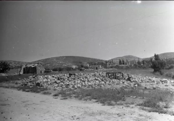


Photos from the village's people
Photos sent in by visitors and published after review.
Add a photo of this village
Log in to add photos of this village.
Other villages from Tulkarm
More from the archive
 Download Our Palestine App
The whole archive in the palm of your hand: depopulated villages, the Nakba, the massacres and Al-Aqsa — free, with no ads to erase the story.
Download Our Palestine App
The whole archive in the palm of your hand: depopulated villages, the Nakba, the massacres and Al-Aqsa — free, with no ads to erase the story.



Comments
No comments yet — be the first to write one.
Add your comment
Name and email are optional. Comments appear after review.