
The depopulated village of Miska / District of Tulkarm
About the depopulated village of Miska
- District
- Tulkarm
- Date Miska was occupied
- 20 April 1948
- Population in 1948
- 1,020
- Military operation
- Coastal Clearing
- Distance from the governorate centre
- 15 (km) Southwest of Tulkarm
- Elevation above sea level
- 50 m
- Cause of displacement
- Expulsion by Zionist troops
- Extent of destruction
- Miska was completely destroyed with the exception of boys' elementary school and its mosque. It should be noted that Miska was destroyed based on the orders of a Jewish National Fund official, Yosef Weitz.
- Ethnic cleansing
- Miska inhabitants were completely ethnically cleansed.
- Settlements built on the land of Miska before 1948
- Sde Warburg
Hover a dot to read the village name, or click to open its card.
Borders of the depopulated village of Miska
Miska – A Depopulated Palestinian Village in the Tulkarm Subdistrict
Miska was a Palestinian village in the Tulkarm Subdistrict, located approximately 15 km southwest of Tulkarm on a slightly elevated sandy hill in the coastal plain, at an average elevation of about 50 meters above sea level.
The village stood along the northern bank of a wadi. Secondary roads connected it with the main road to Tulkarm and with the coastal highway. Its surrounding countryside was intensively agricultural and was particularly noted for citrus orchards, fruit trees, and numerous wells.
Miska's Palestinian inhabitants were expelled during the Nakba and the occupation of Palestine in 1948. Haganah officers ordered them to leave on 15 April, but the villagers refused. On 20–21 April, units of the Alexandroni Brigade attacked Miska and forcibly expelled the population.
- Subdistrict
- Tulkarm
- Distance from Tulkarm
- Approximately 15 km southwest
- Elevation
- Approximately 50 m above sea level
- Palestinian population, 1944/45
- 880
- Total population of the combined 1944/45 statistical unit
- 1,060: 880 Arabs and 180 Jews in Miska and Sde Warburg
- Estimated Palestinian population, 1948
- 1,021
- Total land area of the statistical unit
- 8,076 dunums, including Sde Warburg
- Order to leave
- 15 April 1948; villagers refused
- Attack and expulsion
- 20–21 April 1948
- Military unit
- Alexandroni Brigade of the Haganah
- Military context
- Haganah policy of clearing Palestinian communities from the coastal belt; Palestine Remembered labels the context “Coastal Clearing”
- Zionist settlements established on village land before 1948
- Sde Warburg, 1938; Mishmeret, 1946
Location and Geography of Miska
Miska stood on a low sandy hill in the coastal plain along the northern bank of a wadi.
Secondary roads linked the village to the highway leading toward Tulkarm and to the main coastal road.
Much of the surrounding countryside consisted of agricultural land and orchards. Some areas had previously been wooded before being cleared and planted with fruit trees.
Neighboring Villages and Localities
Palestinian maps and local documentation place Miska among a number of towns and villages, approximately:
- North: al-Tira, or Tira Bani Sa'b.
- South and southeast: Kafr Saba and Qalqiliya.
- Southwest: Tabsur / Khirbat 'Azzun.
- West and northwest: the area toward al-Haram, al-Tira, and the coastal plain.
- Immediately west: Ramat ha-Kovesh, founded in 1932 but not on Miska's land according to Khalidi.
- Northwest of the site: Mishmeret and Sde Warburg on land associated with Miska.
These are approximate geographical relationships and should not be treated as final cadastral boundaries.
Name and Historical Origins
Several explanations have been proposed for the name Miska.
Some historians associate it with an Arab tribe known as Miska whose members may have settled the region before or during the early Islamic period. Khalidi, however, stresses that the relationship between this tribe and the village is uncertain.
A second explanation is connected with medieval Arabic geographical literature. Yaqut al-Hamawi referred to Miska and to a celebrated variety of fruit known as the musk apple, said to have been taken to Egypt during the time of the Fatimid vizier al-Hasan al-Yazuri.
The origin of the village name therefore cannot be established conclusively as either tribal or derived from the musk-like fragrance of its fruit.
Miska in the Medieval Period
The historian al-Safadi recorded several Muslim scholars whose nisba linked them to Miska, including the grammarian and prosodist 'Abd al-Mun'im al-Miski al-Iskandarani, who died in Cairo in 1235.
Miska was also mentioned in a Mamluk endowment document issued for Sultan al-Mansur Qalawun in 1278 in connection with villages around Tira Bani Sa'b, supporting the presence of a locality with this name in the region during the Mamluk period.
The 1596 Record
Some later sources assign a population figure to Miska in 1596, but the identification requires caution.
Khalidi states that a village called Miska was recorded in the nahiya of Jabal Shami in the liwa' of Nablus in 1596, but notes that it was located at a different site. This article therefore does not treat that record as a secure population count for Miska of Tulkarm.
The French Campaign of 1799
French commander Jean-Baptiste Kléber and his troops passed the village on their way toward Acre during Napoleon's campaign in Palestine in 1799.
Miska in the Nineteenth Century
By the late nineteenth century, Miska was a small village with an estimated population of about 300.
Olive trees grew north and south of the village, while fig and palm trees were scattered among the houses and gardens.
Contemporary descriptions also recorded a well to the south of the village.
Built Form
Miska had a roughly square plan and was divided into four unequal sections by two streets intersecting at the village center.
New houses built during the final years of the British Mandate spread northward, away from the wadi.
A mosque and a boys' elementary school were among the principal public buildings.
Population of Miska
The official 1922 Census of Palestine recorded 443 inhabitants in Miska, all Muslims.
By 1931, the population had increased to 635, again all Muslims, living in 123 occupied houses.
The 1944/45 statistics require careful interpretation because Miska and Sde Warburg were grouped in a single statistical unit. That unit had a total population of 1,060: 880 Arabs and 180 Jews.
Because Sde Warburg was the Jewish settlement included in the unit, the Palestinian Arab population of Miska itself was 880.
Palestine Remembered later estimates Miska's Palestinian population at 1,021 in 1948 and the number of refugees and their descendants at 6,269 in 1998. These are retrospective estimates rather than official Mandate census counts.
- Late 19th centuryApproximately 300Historical estimate
- 1922443Official census; all Muslims
- 1931635Official census; all Muslims
- 1944/45880 ArabsPalestinian population of Miska; the combined statistical unit also included 180 Jews in Sde Warburg, for a total of 1,060
- 19481,021Later estimate of Miska's Palestinian population, not an official census
- 19986,269 refugeesLater estimate of refugees and their descendants
Number of Houses
- 1931123Occupied houses recorded in the official census
- 1948197Later Palestine Remembered estimate, not an official Mandate count
Education
Miska had an elementary school for boys.
Khalidi does not provide a securely documented founding date or a complete enrollment record for the school's final Mandate years, so no unsupported founding year or pupil total has been added.
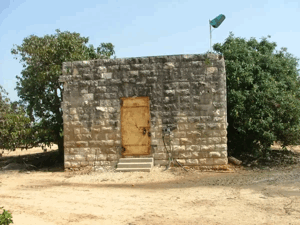
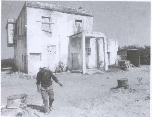
The school later consisted of two principal rooms that survived the destruction of most of the village for decades. Palestinian community documentation records that descendants of Miska restored the building before it was demolished in 2006.
The Mosque
Miska's Muslim inhabitants maintained a village mosque.
In Khalidi's pre-1992 field description, the mosque was still standing and was being used as a storage building for hay bales and agricultural implements.
Later Palestinian community documentation records surviving remains of the older mosque. Material uploaded in 2025 states that a newer adjoining section had been destroyed in 1948.
Village Families
Palestinian local historical documentation records families including Abu Tahoun, Abu Ghazi, al-Ashqar, al-Ballas, al-Jabr, al-Hajj Hamad, al-Zuraiqi, Harb and its branches, Khalaf, Muslih, al-Qadi, Shbayta, Zuhd, Salman, 'Abd al-Qadir, 'Amara, Nasir, Nawwas, Yasin, and al-Sa'i.
These names derive from village and family documentation rather than from Khalidi's principal entry.
Land Ownership in Miska
The combined 1944/45 statistical unit of Miska and Sde Warburg covered 8,076 dunums.
Palestine Remembered presents the simplified ownership categories as follows:
- Palestinian4,924 dunums61%
- Transferred to Zionists2,976 dunums37%
- Communal/Public176 dunums2%
The official Village Statistics use the original categories Arab, Jewish, and Public: 4,924 dunums were classified as Arab land, 2,976 as Jewish land, and 176 as public land.
The official table explicitly states that these figures include Sde Warburg, so they should not be interpreted as a wholly separate ownership table for Arab Miska alone.
Later Palestinian historical research also discusses a much larger communal tract known as Ghabat Miska, or the Miska forest/common. Because that historical tract does not appear as an additional separate component of the 8,076-dunum Village Statistics total, its area should not simply be added to the official figure without a cadastral and land-registry study.
Land Use in 1944/45
- Arab
- Jewish
- Public
- Citrus and bananas2,311 dunums
- Plantations and irrigable land387 dunums
- Cereals4,928 dunums
- Built-up land102 dunums
- Non-cultivable land348 dunums
Cultivable land totaled 7,626 dunums, approximately 94 percent of the statistical unit: 4,664 Arab dunums and 2,962 Jewish dunums.
Built-up and non-cultivable land totaled 450 dunums.
This detailed breakdown corrects simplified tables that assign all 348 dunums of non-cultivable land to Palestinians. The official breakdown is 172 Arab and 176 public dunums.
Economic Life
Agriculture was the principal basis of life in Miska. The relative abundance of wells made it possible to develop extensive citrus and fruit orchards.
In 1944/45, 1,115 Arab dunums were devoted to citrus and bananas, 3,245 to cereals, and 304 to plantations and irrigable agriculture.
Villagers also cultivated vegetables, including cucumbers, as well as watermelons, olives, figs, and palms.
The village's road connections with Tulkarm and the coastal region facilitated the marketing of agricultural produce.
Water and Wells
Wells were relatively abundant in and around Miska.
They supplied domestic water and supported the irrigation of the village's citrus groves and fruit orchards.
After the Nakba, remains of structures associated with village wells continued to be identifiable, including large cement fragments from an enclosure surrounding one of the wells. Local documentation also preserves information on additional wells and public water facilities across the village lands.
Archaeological Remains
Southwest of Miska stood an archaeological mound known as Dhahrat al-Sawwana.
Evidence found there indicated settlement during prehistoric times.
Later Palestinian studies also refer to pottery fragments and flint tools, although the site's detailed archaeological sequence requires specialized independent study.
The Road to Expulsion in 1948
During the spring of 1948, Haganah policy increasingly targeted Palestinian communities in the coastal belt before the end of the British Mandate.
On 15 April 1948, Haganah officers ordered the inhabitants of Miska to leave their village.
The villagers refused and remained in their homes.
Occupation and Depopulation of Miska
Several days later, on 20–21 April 1948, units of the Alexandroni Brigade attacked Miska.
The attacking force expelled the Palestinian inhabitants as part of an earlier Haganah command decision to ensure the evacuation of Arab communities from the coastal region between Tel Aviv and Zikhron Ya'akov before 15 May 1948.
Palestine Remembered lists 20 April as the occupation date and labels the military context “Coastal Clearing.” Khalidi's detailed account, however, gives a 20–21 April range and does not establish “Coastal Clearing” as a formal operation name.
This article therefore uses 20–21 April 1948 for the attack and expulsion and identifies the Alexandroni Brigade as the village-specific attacking force.
- 15 April 1948
Order to leave
Haganah officers order Miska's inhabitants to leave; the villagers refuse
- 20–21 April 1948
Attack on Miska
Alexandroni Brigade units attack the village
- 20–21 April 1948
Expulsion
The Palestinian inhabitants are forcibly expelled
- Spring 1948
Military context
Haganah decision to evacuate Arab communities from the coastal belt between Tel Aviv and Zikhron Ya'akov
- Alexandroni Brigade
Village-specific military unit
The unit identified by Khalidi as attacking Miska
Destruction of Miska
The depopulation of Miska was followed by the physical destruction of the village.
In early June 1948, the Jewish National Fund began demolishing Miska together with several other Palestinian villages.
Khalidi, citing Israeli records, states that on 16 June 1948 Israeli prime minister David Ben-Gurion noted in his diary that the destruction of Miska was under way, while avoiding the issuance of explicit written authorization for the demolitions.
Later Palestinian local documentation states that demolition and leveling continued in subsequent years, culminating in extensive destruction of the village houses and cemetery around 1951.
The school survived much longer. Descendants of the village restored it in the mid-2000s, but the building was demolished in 2006.
Zionist and Israeli Settlements on Miska's Lands
Sde Warburg: Established in 1938 on land traditionally belonging to Miska.
Mishmeret: Established in 1946 northwest of the village site on Miska's lands.
Ramat ha-Kovesh: Founded in 1932 approximately one kilometer west of Miska but, according to Khalidi, not on village land.
Khalidi does not identify a separate new Israeli settlement founded after 1948 directly over Miska's built-up center. Large areas of the depopulated lands were instead incorporated into agricultural use, especially citrus cultivation, and into the land use of neighboring settlements.
Miska Today
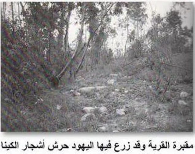
In the fieldwork underlying All That Remains, published in 1992, Khalidi described the Miska site as covered with citrus orchards, with cactus growing along their edges.
At that time, the two-room school still stood and was used by orchard guards, while the mosque served as a storehouse for hay and agricultural implements. Large cement fragments from the enclosure surrounding a village well were also visible.
That description no longer reflects every later change. Palestinian community documentation records that descendants of Miska restored the school in 2005 and that it was demolished in 2006. It is therefore inaccurate to describe the school as still standing in 2026.
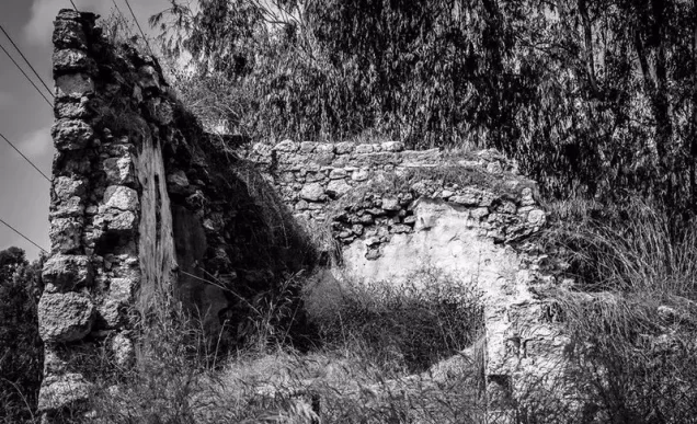
Palestine Remembered also documents remains associated with the mosque, wells, house locations, and rubble. Material uploaded in September 2025 shows remains identified by contributors as part of the old mosque and states that a newer adjoining section was destroyed in 1948.
The upload date does not necessarily establish the date on which each photograph was taken, so this is best treated as later community documentation rather than a comprehensive architectural survey of the site in 2026.
Citrus cultivation and other agricultural use remain central to the transformed landscape described in the available documentation, while most of the original Palestinian built fabric has disappeared.
Sources
- PalQuestPalQuest – Interactive Encyclopedia of the Palestine Question: Miska
- Palestine RememberedPalestine Remembered – Miska, Tulkarm
- Palestine RememberedPalestine Remembered – Miska entry from All That Remains
- Institute for Palestine StudiesInstitute for Palestine Studies – Walid Khalidi, All That Remains
- pcbs.gov.psGovernment of Palestine – Census of Palestine 1922
- fada.birzeit.eduBirzeit University Repository – Census of Palestine 1931
- maktabatsabil.comGovernment of Palestine – Village Statistics 1945: Tulkarm Sub-District, Population and Land Ownership
- maktabatsabil.comGovernment of Palestine – Village Statistics 1945: Tulkarm Sub-District, Built-up and Non-Cultivable Land
- Palestine RememberedPalestine Remembered – later Palestinian documentation of the destruction of Miska and its school
Photo gallery



Photos from the village's people
Photos sent in by visitors and published after review.
Add a photo of this village
Log in to add photos of this village.
Other villages from Tulkarm
More from the archive
 Download Our Palestine App
The whole archive in the palm of your hand: depopulated villages, the Nakba, the massacres and Al-Aqsa — free, with no ads to erase the story.
Download Our Palestine App
The whole archive in the palm of your hand: depopulated villages, the Nakba, the massacres and Al-Aqsa — free, with no ads to erase the story.



Comments
No comments yet — be the first to write one.
Add your comment
Name and email are optional. Comments appear after review.