
The depopulated village of Raml Zayta / District of Tulkarm
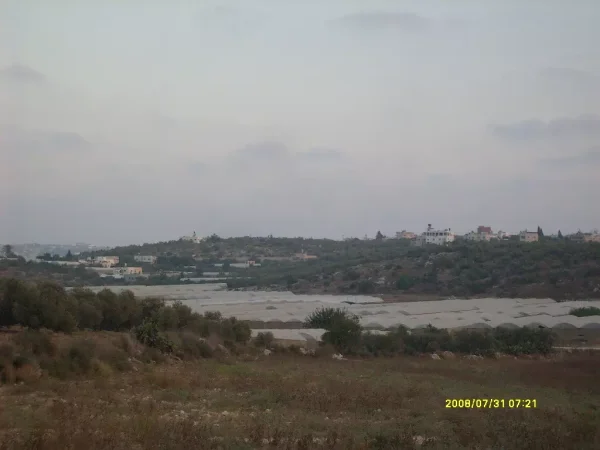
Raml Zayta
About the depopulated village of Raml Zayta
- District
- Tulkarm
- Date Raml Zayta was occupied
- 15 March 1948
- Population in 1948
- 140
- Military operation
- Coastal Clearing
- Distance from the governorate centre
- 15 (km) Northeast of Tulkarm
- Elevation above sea level
- 25 m
- Cause of displacement
- Expulsion by Zionist troops
- Extent of destruction
- Raml Zayta was mostly destroyed with the exception of two houses, one of which is currently being occupied by an Israeli Jewish family.
- Ethnic cleansing
- Raml Zayta inhabitants were completely ethnically cleansed.
- Settlements built on the built-up area of Raml Zayta after 1948
- Moshav Sde Yitzhak, Hadera
Hover a dot to read the village name, or click to open its card.
Borders of the depopulated village of Raml Zayta
Raml Zayta (Khirbat Qazaza) – Depopulated Palestinian Village of the Tulkarm District
Raml Zayta, also known as Khirbat Qazaza, was a depopulated Palestinian village in the Tulkarm District. It stood on flat sandy ground on the central coastal plain, approximately 15 kilometers from Tulkarm, at an average elevation of about 25 meters above sea level.
Its inhabitants were displaced during the Nakba and the 1948 occupation of Palestine amid early Haganah operations directed against Palestinian communities on the central coastal plain. Walid Khalidi does not establish an exact date for the village's depopulation. Some later Palestinian listings give 15 March 1948, while Khalidi states more cautiously that Raml Zayta was probably depopulated under circumstances similar to those of neighboring communities targeted by the Haganah during March and April.
Name and Location
The principal name recorded in the sources is Raml Zayta, while Khirbat Qazaza is given as an alternative name.
It is important not to confuse this village with Qazaza in the Ramla District. The two were separate Palestinian villages with different locations, populations, land areas, and histories of depopulation.
Raml Zayta stood on a flat sandy tract on the central coastal plain. A secondary road linked it to the main coastal highway, while dirt tracks connected it with nearby roads and communities.
The village lay approximately 15 kilometers from Tulkarm and had an average elevation of about 25 meters above sea level.
Raml Zayta and Zayta
Raml Zayta lay in the area northwest of the village of Zayta. The distinction between the two settlements is particularly important when interpreting the 1931 census.
In that census, Raml Zayta and Zayta were counted together. Separate population figures for Raml Zayta therefore cannot be derived from the combined 1931 total.
By 1945, however, the official statistics listed Raml Zayta independently, with its own population and land figures.
Population and Houses
The inhabitants of Raml Zayta were Palestinian Arab Muslims. A complete independent population series is not available because the village was combined with Zayta in the 1931 census.
- 19311,165Official combined figure for Raml Zayta and Zayta; it does not represent Raml Zayta alone
- 1945140Official independent figure for Raml Zayta; all inhabitants were Muslims
- 1948About 162Later estimate, not an official British census
- 1998About 997 refugees and descendantsLater demographic estimate published by Palestine Remembered
The 1931 census recorded 237 houses for Raml Zayta and Zayta together. This figure must not be presented as the house count of Raml Zayta alone. No separate official house count for Raml Zayta in 1945 was found in the principal sources reviewed.
Built Environment and Daily Life
The houses of Raml Zayta were scattered rather than arranged in a compact or regular pattern, and most stood in the middle of agricultural holdings. They were constructed of mud, stone, and cement.
A small number of shops were dispersed among the houses and supplied some of the villagers' everyday needs.
Walid Khalidi's principal entry does not independently document a school or mosque in Raml Zayta. Such features have therefore not been added on the basis of online material that appears to have mixed information from Raml Zayta with that of Qazaza in the Ramla District.
Water Resources
The villagers obtained domestic water from wells. Well water was also used to irrigate part of the agricultural land and orchards.
The principal source does not identify a particular well or spring by name. Water-source names belonging to neighboring Zayta have therefore not been transferred to Raml Zayta without evidence.
Economic Life and Agriculture
Agriculture and livestock raising formed the principal basis of the village economy. Most cultivation was rainfed, while some fields and orchards were irrigated with water drawn from wells.
The principal crops included cereals, vegetables, and watermelons, together with citrus, bananas, and a small area of irrigated orchards.
The 1944/45 official statistics classified 14,267 dunams, or approximately 96 percent of the village land, as cultivated or cultivable.
Land Ownership, 1944/45
The total land area of Raml Zayta was 14,837 dunams. Under the official Government of Palestine categories, ownership was distributed as follows:
- Arab12,720 dunums86%
- Jewish1,453 dunums10%
- Public664 dunums4%
When the same figures are reproduced using Palestine Remembered's simplified terminology, the source's categories should be preserved as “Palestinian,” “Transferred to Zionists,” and “Communal/Public.” “Transferred to Zionists” should not be silently replaced with “Jewish ownership,” since the two tables use different terminology.
Land Use, 1944/45
- Arab
- Jewish
- Public
- Cereals14,106 dunums
- Citrus and bananas130 dunums
- Plantations and irrigable land31 dunums
- Total cultivable/cultivated land14,267 dunums
- Non-cultivable land570 dunums
The table balances exactly: 14,267 dunams of cultivable or cultivated land plus 570 dunams of non-cultivable land equal the total village area of 14,837 dunams.
The official table does not provide a separate built-up-area figure for Raml Zayta.
Khirbat Tall Durur
Khirbat Tall Durur lay in the eastern part of Raml Zayta's lands. Walid Khalidi records that it had been a prosperous village in the Haifa District during the Ottoman period.
It was depopulated during the British Mandate as a result of the dispute over the lands of neighboring Wadi al-Hawarith. Khirbat Tall Durur should therefore be distinguished from the residential core of Raml Zayta when discussing the village's demographic history.
Depopulation of Raml Zayta
Walid Khalidi states that there is no firm direct information establishing the exact date or detailed circumstances of the depopulation of Raml Zayta.
He places the village within the context of early Haganah operations intended to “clear” the central coastal area of Palestinian communities. As nearby examples, he notes that Wadi al-Hawarith was attacked and its inhabitants pressured to leave on 15 March 1948, while the residents of Arab al-Fuqara' were expelled on 10 April following a decision by the Haganah General Staff.
Khalidi therefore considers it possible that the inhabitants of Raml Zayta were displaced under similar circumstances.
Later Palestinian listings give 15 March 1948 as the date of Raml Zayta's depopulation. This date may be reported as a later indexed date, but it should not be presented as a date firmly established in Khalidi's village account.
The available evidence does not securely connect Raml Zayta with a formally named military operation, nor does it identify a specific Haganah brigade or battalion responsible for entering the village. The most accurate formulation is therefore that its depopulation occurred in the context of early Haganah operations on the central coastal plain.
Occupation Chronology
- March 1948
Expansion of Haganah operations on the central coast
Early Haganah operations targeted Palestinian communities across the central coastal area.
- 15 March 1948
Attack on nearby Wadi al-Hawarith
Residents were pressured into leaving; Khalidi uses this as one of the neighboring cases relevant to understanding Raml Zayta's likely depopulation circumstances.
- Exact date uncertain; later Palestinian listings give 15 March 1948
Depopulation of Raml Zayta
Khalidi does not establish a direct village-specific date and states only that Raml Zayta was probably depopulated under circumstances similar to nearby communities.
- 10 April 1948
Expulsion of Arab al-Fuqara'
The neighboring community was expelled following a Haganah General Staff decision, providing another documented example of the pattern of operations in the area.
- March–April 1948
Military force
Haganah forces; the village-specific sources do not securely identify a brigade or battalion.
- Exact date not documented
Destruction of most village buildings
Later field research found that only two original houses survived, but the date of demolition is not documented.
Israeli Settlements on Village Lands
Sde Yitzhaq was established on the lands of Raml Zayta in 1952.
Hadera, originally established as a settlement in 1890, later expanded so that some of its suburbs came to occupy land belonging to Raml Zayta.
It is therefore important to distinguish between Sde Yitzhaq, established after the Nakba directly on village land, and Hadera, which predated 1948 but subsequently expanded onto part of Raml Zayta's lands.
Raml Zayta Today
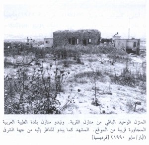
According to the field description published in Walid Khalidi's All That Remains, stone rubble was visible throughout the village site, and only two of the original houses remained.
At the time of the survey, one of these houses was still inhabited by the only Palestinian family that had remained in the village. The second had been renovated and enlarged with additional rooms and was occupied by a Jewish family.
Cactuses and eucalyptus, fig, mulberry, and pomegranate trees grew at the site, while parts of the village lands were used for vegetables and orchards.
This description should not be treated as a field verification of the site in 2026. Field research for the All That Remains project was carried out between 1987 and 1990. The description therefore records conditions during that survey period; the principal sources reviewed here do not provide a comprehensive recent field survey confirming the present condition of the two houses or the other surviving features.
Sources
- PalQuest – Interactive Encyclopedia of the Palestine Question: Raml Zayta
- Palestine Remembered – Raml Zayta, Tulkarm District
- Village Statistics 1945 – Tulkarm Sub-District table, reproduced by Sami Hadawi
- WAFA – List of Palestinian towns and villages occupied and depopulated in 1948
- PalQuest – Qazaza, Ramla District; included to distinguish it from Khirbat Qazaza/Raml Zayta
- PalQuest – All That Remains: Methodology
Photos from the village's people
Photos sent in by visitors and published after review.
Add a photo of this village
Log in to add photos of this village.
Other villages from Tulkarm
More from the archive
 Download Our Palestine App
The whole archive in the palm of your hand: depopulated villages, the Nakba, the massacres and Al-Aqsa — free, with no ads to erase the story.
Download Our Palestine App
The whole archive in the palm of your hand: depopulated villages, the Nakba, the massacres and Al-Aqsa — free, with no ads to erase the story.



Comments
No comments yet — be the first to write one.
Add your comment
Name and email are optional. Comments appear after review.