
The depopulated village of Salama / District of Jaffa
Subdistrict: Yafa
Estimated population of Salama in 1948: 7,810
Date of occupation and depopulation: 29–30 April 1948
Military operation: Operation Hametz
Military unit: Alexandroni Brigade
Israeli settlement established partly on Salama’s land before 1948: Ramat Gan
Israeli neighbourhood established on the village’s built-up site after 1948: Kfar Shalem
Israeli neighbourhoods subsequently constructed on Salama’s land: Neve Kfir, Neve Tzahal, Beit Ya'akov, Neve Eliezer, Nir Aviv, Livne, HaArgazim, Tel Haim, Ramat Shikma, and Ramat Hen
General Information about Salama
Salama was located approximately 5 kilometres east of Yafa.
The village stood on level ground in the central coastal plain, approximately two kilometres north of the main Yafa–al-Lydd road. Its proximity to Yafa contributed significantly to its economic, commercial, social, and educational development.
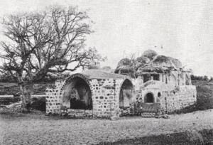
The inhabitants traditionally associated the village’s name with Salama Abu Hashim, believed to have been a companion of the Prophet Muhammad and to have been buried there in 634 CE. His tomb, in the northwestern part of the village, became known as the shrine of Sayyiduna Salama. This association belongs to local religious tradition; the precise historical identity and burial date cannot be independently confirmed.
Boundaries of Salama
Salama was surrounded by the following Palestinian localities, agricultural areas, and neighbouring settlements:
- To the north and northwest: the Qabbaniyat orchard district and the vicinity of Sarona.
- To the north and northeast: Jewish settlements and the expanding area of Ramat Gan.
- To the east and southeast: al-Khayriyya and its lands.
- To the south and southwest: Yazur and the Yafa–al-Lydd road.
- To the west: the outskirts and orchard districts of Yafa.

Architectural Structure of Salama
During the British Mandate, Salama was divided into quarters, each inhabited by a hamula—an extended family or clan—or by one of its branches. The earliest houses were clustered closely together, with the homes of each hamula arranged around a spacious communal courtyard, or hawsh, with a single shared entrance.
The courtyard provided women with a private area for household work, children with a place to play, and families with a shared space in which to gather in the evenings and on special occasions. Some families constructed houses in the surrounding orchards, although these households did not usually form part of the original hamula-based residential clusters.
Most houses were initially built of adobe brick. Some villagers constructed stone houses or houses in the Baghdadi style, using timber covered with clay and finished internally with limewash. This method helped insulate the interior from seasonal heat.
Population of Salama
In 1945, Salama had 6,730 inhabitants, comprising 6,670 Muslims and 60 Christians.
| Year | Population* |
|---|---|
| 1596 | Approximately 94 |
| 1922 | 1,187 |
| 1931 | 3,691 |
| 1945 | 6,730 |
| 1948 | Approximately 7,810 |
| Estimated refugee population in 1998 | 47,942 |
* The figures for 1596 and 1948, as well as the 1998 refugee population, are estimates rather than contemporary census counts.
Number of Houses in Salama
| Year | Number of houses |
|---|---|
| 1931 | 800 |
| 1948 | Approximately 1,692 |
* The 1948 figure is an estimate rather than a contemporary housing census.
Economic Life in Salama
Salama contained numerous shops and five coffeehouses. During the British Mandate, villagers established a transport company that owned cars and buses in partnership with residents of the neighbouring village of al-'Abbasiyya. It was known as the Salama–al-'Abbasiyya Automobile Company.
Most inhabitants worked in agriculture and related occupations, while smaller numbers were engaged in commerce and government employment. Agriculture combined rainfed and irrigated cultivation. Irrigation water was drawn from approximately eighty-five wells.
The fertile lands of Salama were especially noted for citrus cultivation. In 1944/45, 3,248 dunams were devoted to citrus groves, including 2,853 dunams under Palestinian ownership and 395 dunams under Jewish ownership. A further 684 dunams were irrigated or used for other orchards, while 2,406 dunams were devoted to cereal cultivation.
Farmers transported their produce to markets in Yafa and sold some of it in neighbouring Jewish settlements. Milk was also delivered to a dairy in Yafa owned by two men from Salama.
Land Ownership in Salama
| Ownership category | Land area in dunams* |
|---|---|
| Palestinian ownership | 5,633 |
| Jewish ownership | 885 |
| Public land | 264 |
| Total | 6,782 |
* One dunam equals approximately 1,000 square metres.
Land Use in Salama, 1944/45
| Land-use category | Palestinian ownership (dunams)* | Jewish ownership (dunams)* | Public land (dunams)* | Total (dunams)* |
|---|---|---|---|---|
| Citrus groves | 2,853 | 395 | 0 | 3,248 |
| Other irrigated land and orchards | 370 | 314 | 0 | 684 |
| Cereal cultivation | 2,266 | 140 | 0 | 2,406 |
| Built-up area | 114 | 0 | 0 | 114 |
| Cultivable land | 5,489 | 849 | 0 | 6,338 |
| Uncultivated land | 30 | 36 | 264 | 330 |
* One dunam equals approximately 1,000 square metres.
The approximately 25 dunams planted with olive trees formed part of the broader orchard classifications and should not be added separately to the land-use totals.
Education in Salama
Salama had two elementary schools, one for boys and another for girls. The boys’ school opened in 1920, while the girls’ school opened in 1936. In 1941, the two schools enrolled 504 boys and 121 girls respectively. The villagers also maintained a football team.
The Shrine of Sayyiduna Salama
The village shrine was traditionally associated with Salama Abu Hashim, whom local tradition identified as a companion of the Prophet Muhammad. The shrine stood in the northwestern part of the village and remained an important religious and cultural landmark for its inhabitants.
The longer genealogical identification sometimes given for this figure is not consistently supported by historical sources. The concise form “Salama Abu Hashim,” preserved in Palestinian village accounts, has therefore been used here.
Occupation and Depopulation of Salama
Because Salama was surrounded by expanding Jewish settlements, it was exposed to repeated armed attacks for nearly five months, beginning in December 1947. Palestinian historian 'Arif al-'Arif records a major attack on 28 December that was preceded by a diversionary assault from the direction of Petah Tikva. The village defenders repelled the attack and subsequently mounted a counterattack with volunteers from al-Lydd and al-'Abbasiyya.
Following the United Nations partition resolution of November 1947, villagers organized a local militia estimated at approximately thirty men. Skirmishes around Salama became frequent. On 18 January 1948, the Third Battalion of the Alexandroni Brigade carried out another large attack on the northern section of the village, during which several houses were destroyed.
Further major attacks took place on 28 February and 15–16 April. The Arab Liberation Army sent approximately twenty fighters to assist the village during the February attack. Contemporary reports stated that an attacking force of about 250 men took part, including an advance unit of fifty. Six members of the attacking force were killed after the advance unit was surrounded by the village’s defenders. A Palestinian communiqué published in the newspaper Filastin reported that three Palestinians, including one woman, were killed. These casualty figures derive from contemporary reports and should be understood within that evidentiary context.
During the April attack, at least thirty three-inch mortar shells were reportedly fired at Salama from positions near Petah Tikva. The attacks continued into the second half of April. As the defenders’ ammunition ran out and the military pressure increased, residents began leaving the village.
The final occupation took place during Operation Hametz, whose objective was to encircle and occupy Yafa and the Palestinian villages on its eastern approaches. Units of the Alexandroni Brigade entered Salama on 29 April 1948. Palestinian historian 'Arif al-'Arif stated that the forces did not enter until they had confirmed that the inhabitants had left. The village was empty by 30 April, and contemporary reporting described its surrender on that date. Sources therefore variously give 29 or 30 April as the date of occupation.
The displaced villagers sought refuge in several areas, including Ramallah, Nablus, Gaza, and Jordan. Their displacement formed part of Israel’s occupation of Palestine—the Nakba.
Israeli Urban Expansion on Salama’s Land
Ramat Gan, established in 1921, expanded partly onto land belonging to Salama. After the village’s occupation and depopulation, Kfar Shalem was established over part of its built-up site.
Urban expansion subsequently absorbed most of Salama’s remaining land into the eastern neighbourhoods of Tel Aviv and the southern neighbourhoods of Ramat Gan. These areas include Neve Kfir, Neve Tzahal, Beit Ya'akov, Neve Eliezer, Nir Aviv, Livne, HaArgazim, Tel Haim, Ramat Shikma, and Ramat Hen.
Salama Today
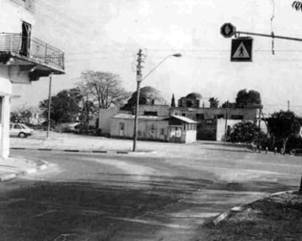
Much of Salama was destroyed or absorbed into later urban development. Nevertheless, a number of Palestinian buildings survived, including several houses, four former coffeehouses, the mosque, the shrine of Sayyiduna Salama, a cemetery, and the two village schools.
Many of the surviving houses have been abandoned or left in poor condition, while others have been occupied and adapted for later use. Most are concrete buildings of one or two storeys and display a variety of architectural features, including rectangular and arched doors and windows.
The surviving buildings, religious landmarks, cemetery, and remnants of the village’s residential fabric continue to bear witness to Salama’s Palestinian history despite the extensive transformation of its land.
Sources
- Walid Khalidi, ed., All That Remains: The Palestinian Villages Occupied and Depopulated by Israel in 1948, Institute for Palestine Studies, 1992.
- Palestine Remembered, “Salama, Yafa”.
- Sami Hadawi, Village Statistics 1945: A Classification of Land and Area Ownership in Palestine, Palestine Liberation Organization Research Centre.
- Government of Palestine, Village Statistics, April 1945, Department of Statistics and Department of Lands.
- Government of Palestine, Census of Palestine, 1931: Population of Villages, Towns and Administrative Areas.
- 'Arif al-'Arif, Al-Nakba: Nakbat Bayt al-Maqdis wa-l-Firdaws al-Mafqud, 1947–1952.
- Encyclopedia of Palestinian Villages, “Salama”.
- Our Palestine, “The Depopulated Village of Salama”.
Photo gallery


Photos from the village's people
Photos sent in by visitors and published after review.
Add a photo of this village
Log in to add photos of this village.
Other villages from Jaffa
 Download Our Palestine App
The whole archive in the palm of your hand: depopulated villages, the Nakba, the massacres and Al-Aqsa — free, with no ads to erase the story.
Download Our Palestine App
The whole archive in the palm of your hand: depopulated villages, the Nakba, the massacres and Al-Aqsa — free, with no ads to erase the story.



Comments
No comments yet — be the first to write one.
Add your comment
Name and email are optional. Comments appear after review.