
The depopulated village of Dayr Abu Salama / District of Ramla

Dayr Abu Salama
About the depopulated village of Dayr Abu Salama
- District
- Ramla
- Date Dayr Abu Salama was occupied
- 13 July 1948
- Population in 1948
- 70
- Military operation
- Operation Dani
- Distance from the governorate centre
- 8 (km) Northeast of al-Ramla
- Elevation above sea level
- 175 m
- Cause of displacement
- Military assault by Zionist troops
- Extent of destruction
- Based on the orders of a Jewish National Fund (JNF) official, Yosif Weitz, Dayr Abu Salama was completely obliterated.
- Ethnic cleansing
- Dayr Abu Salama inhabitants were completely ethnically cleansed.
Hover a dot to read the village name, or click to open its card.
Borders of the depopulated village of Dayr Abu Salama
Dayr Abu Salama – Depopulated Palestinian Village of the Ramla Subdistrict
Dayr Abu Salama was a small Palestinian village in the Ramla Subdistrict, located on a flat hilltop in the central coastal plain approximately 8 kilometers northeast of Ramla and at an average elevation of about 175 meters above sea level.
Although small in population and land area, the village occupied fertile agricultural land with comparatively abundant groundwater. A secondary road connected it with the main Ramla–Lydda road, while dirt paths linked it with neighboring villages.
- Subdistrict
- Ramla
- Distance from Ramla
- Approximately 8 km northeast
- Average Elevation
- Approximately 175 meters
- Type of Locality
- Small village/hamlet, classified as a hamlet in the Palestine Index Gazetteer
- Population in 1922
- 30 – official Census of Palestine; all Muslims
- Population in 1931
- No independently documented village-specific figure established from the sources used
- Population in 1944/1945
- 60
- Estimated Population in 1948
- Approximately 70 – later estimate, not an official census
- Total Land Area in 1945
- 1,195 dunums
- Occupation and Depopulation Date
- 13 July 1948
- Military Operation
- Operation Dani – second phase
- Military Unit
- Yiftach Brigade is the formation most directly associated with the capture phase; the specific battalion is not independently established
- Cause of Displacement
- Military assault, with the remaining inhabitants likely expelled after Israeli forces entered the village
- Extent of Destruction
- The village houses were extensively destroyed and their stones later reused on the site; no reliable numerical destruction percentage is available
- Post-1948 Settlements
- No Israeli settlements are documented on village lands by Khalidi/PalQuest
Location
Dayr Abu Salama stood on a flat hilltop surrounded by lower hills and overlooked broad areas of the central coastal plain.
A secondary road connected the village with the main road leading to Lydda and Ramla, while dirt tracks linked it with neighboring rural communities.
Palestinian local documentation identifies nearby places including al-Haditha to the north, Budrus to the northeast, Ni'lin to the east, Khirbat Zakariyya to the southeast, Jimzu to the south, Khirbat al-Duhayriyya to the southwest, and Lydda and its lands to the west and northwest.
Origin of the Name
A shrine dedicated to Shaykh Abu Salama stood on the eastern outskirts of the village.
Walid Khalidi considers this shrine the most likely origin of the name Dayr Abu Salama.
Archaeological Remains
The village site contained evidence of earlier settlement.
Khalidi records:
- Remains of an old monastery.
- Rock-cut tombs.
Later Palestinian documentation additionally mentions rock-cut burials with Greek inscriptions and an archaeological site east of the village known as Khirbat Harmush.
Village Layout and Houses
Dayr Abu Salama had an irregular layout and was classified as a hamlet in the Mandate-era Palestine Index Gazetteer.
Its inhabitants were predominantly Muslim, and the houses were built largely of adobe brick.
Some later Palestinian references describe approximately ten houses around the time of the Nakba. This is treated as a later estimate rather than an official 1931 or 1945 occupied-house count.
Population in 1922
The official 1922 Census of Palestine recorded approximately 30 inhabitants at Dayr Abu Salama, all Muslims.
Population in 1931
No clearly separate Dayr Abu Salama population figure was established from the official 1931 material used for this article.
No number is therefore extrapolated mathematically from the 1922 and 1945 figures.
Population in 1945
The population of Dayr Abu Salama was approximately 60 in 1944/45.
The inhabitants were predominantly Muslim.
Estimated Population in 1948 and Refugees
Palestinian documentation gives an estimated 70 inhabitants for Dayr Abu Salama in 1948.
This is a later demographic estimate rather than an official census conducted in 1948.
An estimated 427 refugees and descendants is given for 1998. This too is a later demographic estimate rather than a comprehensive official census.
| Year | Population | Nature of Figure |
|---|---|---|
| 1922 | 30 | Official Census of Palestine |
| 1931 | Not independently available | No unsupported estimate used |
| 1944/1945 | 60 | Official Mandate-era statistics |
| 1948 | 70 | Later estimate |
| 1998 | 427 refugees and descendants | Later demographic estimate |
Land Ownership in 1945
The total land area of Dayr Abu Salama was 1,195 dunums.
- Palestinian1,195 dunums100%
- Transferred to Zionists0 dunums0%
- Communal/Public0 dunums0%
The entire recorded village land area was therefore in the Arab/Palestinian ownership category in the 1945 statistics.
Land Use in 1945
- Cereals695 dunums36%
- Plantations and Irrigable Land41 dunums2%
- Total Cultivated/Cultivable Land736 dunums38%
- Non-Cultivable Land459 dunums24%
Approximately 62 percent of the village land was cultivated or cultivable, while about 38 percent was classified as non-cultivable.
Agriculture and Economic Life
Dayr Abu Salama's agricultural land, particularly north of the village, was fertile and benefited from relatively abundant groundwater.
Two reservoirs were located in the area.
The principal crops included:
- Cereals.
- Vegetables.
- Olives.
- Citrus fruits.
- Grapes.
- Figs.
Cereal cultivation occupied the largest recorded area, totaling 695 dunums in 1944/45.
Water
The village lands were relatively rich in groundwater for such a small locality.
Two reservoirs were present in the area and supported agricultural cultivation and the irrigation of some orchards and vegetable plots.
Education
Khalidi's principal village entry does not identify an independent school in Dayr Abu Salama.
Later Palestinian documentation states that the village had no school and that some children attended schools in Lydda.
This is retained with caution because it is not independently detailed in the principal source used for the village.
Operation Dani
Operation Dani began on 9 July 1948 and ended on 18 July 1948.
It was the largest Israeli offensive during the “Ten Days” between the two truces.
The operation had two phases:
- First phase, 9–12 July: focused primarily on Lydda, Ramla, and their immediate surroundings.
- Second phase, 13–18 July: expanded eastward toward the Ramallah–Latrun road and the hinterland east of Lydda and Ramla.
The Yiftach, Har'el, Kiryati, Alexandroni, and Etzioni brigades participated in Operation Dani at the operation-wide level.
Occupation of Dayr Abu Salama
After the occupation of Lydda during the first phase of Operation Dani, Israeli forces spread through the surrounding countryside and overran additional villages.
Dayr Abu Salama was captured on 13 July 1948.
Since the second phase of Operation Dani began on 13 July, the village fell on the first day of the operation's second phase.
The Yiftach Brigade
Two days before Dayr Abu Salama was captured, Operation Dani headquarters issued orders to the Yiftach Brigade to fortify every position taken and to destroy houses not required for Israeli troop accommodation.
Palestinian documentation identifies Yiftach as the formation most directly associated with the capture of Dayr Abu Salama.
The principal sources reviewed, however, do not establish the exact battalion that entered the village.
The most accurate formulation is therefore:
Military unit: Yiftach Brigade; specific executing battalion not independently documented.
Cause of Displacement
Dayr Abu Salama was depopulated in the context of the military offensive during Operation Dani.
The principal source does not provide a detailed account of what happened to every resident when Israeli forces entered.
Khalidi nevertheless considers it likely that inhabitants who remained in their homes were expelled after the occupation, as occurred in Lydda, Ramla, and a number of other localities captured during the operation.
The most supportable description is therefore displacement caused by military assault, with the remaining inhabitants likely expelled after the village was captured.
Occupation and Displacement Chronology
- 9 July 1948
Beginning of Operation Dani
A major Israeli offensive began in the Lydda–Ramla region.
- 9–12 July 1948
First Phase
Lydda and other strategic locations were occupied, allowing Israeli forces to spread into the surrounding countryside.
- 11 July 1948
Operation Dani Orders to Yiftach
The brigade was instructed to consolidate captured positions and destroy houses not required for troop use.
- 13 July 1948
Beginning of Second Phase
Operations expanded eastward toward the Ramallah–Latrun axis.
- 13 July 1948
Occupation of Dayr Abu Salama
The village fell on the first day of Operation Dani's second phase.
- July 1948
Depopulation
The village was emptied of its Palestinian inhabitants; those remaining after the assault were likely expelled.
- 18 July 1948
End of Operation Dani
The operation ended after a major shift in military control across the Ramla region.
Extent of Destruction
Dayr Abu Salama's houses were extensively destroyed after the inhabitants were displaced.
The later site description confirms that stones taken from destroyed village houses were reused to construct a watchtower and an amphitheater on the site.
No reliable building-by-building survey provides a numerical destruction percentage, so no unsupported percentage is used.
Israeli Settlements on Village Land
Walid Khalidi and PalQuest state that no Israeli settlements were established on Dayr Abu Salama village lands.
Nearby Ben Shemen should therefore not be classified as a settlement built on Dayr Abu Salama land solely because of geographic proximity.
Dayr Abu Salama Today
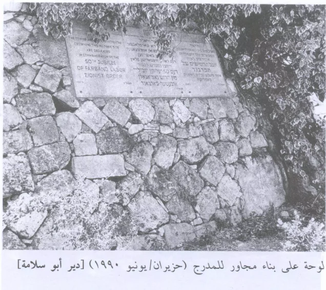
The available description of the village site is based primarily on historical fieldwork incorporated into Walid Khalidi's All That Remains, including documentation from around 1990. It should not be treated as direct 2026 field verification.
At the time of that documentation, the village site had been converted into a picnic and recreation area surrounded by pine and cypress trees.
Stones taken from the destroyed Palestinian houses had been used to construct a watchtower and an amphitheater, while the ground in front of the amphitheater had been leveled and planted with grass.
Old fig and olive trees remained at the site, while cactuses and carob trees grew along its western and northern edges.
No Israeli settlement was documented on the village lands themselves, although the original Palestinian built environment had been profoundly transformed.
Sources
- PalQuest – Interactive Encyclopedia of the Palestine Question: Dayr Abu Salama
- PalQuest – Operation Dani
- Institute for Palestine Studies – Walid Khalidi, All That Remains
- Palestine Remembered – Dayr Abu Salama, Ramla
- Government of Palestine – Census of Palestine, 1922: Dair Abu Salameh
- Encyclopedia of Palestinian Villages – Dayr Abu Salama
Photo gallery
Photos from the village's people
Photos sent in by visitors and published after review.
Add a photo of this village
Log in to add photos of this village.
Other villages from Ramla

More from the archive



 Download Our Palestine App
The whole archive in the palm of your hand: depopulated villages, the Nakba, the massacres and Al-Aqsa — free, with no ads to erase the story.
Download Our Palestine App
The whole archive in the palm of your hand: depopulated villages, the Nakba, the massacres and Al-Aqsa — free, with no ads to erase the story.



Comments
No comments yet — be the first to write one.
Add your comment
Name and email are optional. Comments appear after review.