
The depopulated village of Daniyal / District of Ramla
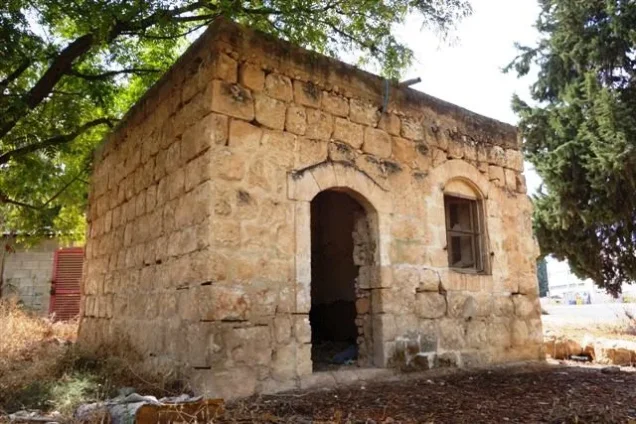
Daniyal
About the depopulated village of Daniyal
- District
- Ramla
- Date Daniyal was occupied
- 10 July 1948
- Population in 1948
- 480
- Military operation
- Operation Dani
- Elevation above sea level
- 100 m
- Cause of displacement
- Military assault by Zionist troops
- Extent of destruction
- On September 13th, 1948, Daniyal was mostly destroyed with the exception of few houses, a shrine, and the boys school.
- Ethnic cleansing
- Daniyal inhabitants were completely ethnically cleansed.
Hover a dot to read the village name, or click to open its card.
Borders of the depopulated village of Daniyal
Daniyal – Depopulated Palestinian Village of Ramla
Daniyal was a Palestinian village in the Ramla Subdistrict and the Lydda administrative district during the British Mandate. It stood on flat terrain in the central coastal plain, approximately 5 kilometers east of Ramla according to PalQuest, while other Palestinian geographical sources give a distance of about 6 kilometers.
The village had an average elevation of about 100 meters above sea level. Two secondary roads connected it with Lydda and Ramla, while dirt tracks led to Jimzu, 'Innaba, Kharruba, Khirbat al-Duhayriyya, and other nearby communities.
Daniyal's population reached 410 in the official 1944/45 statistics, and its lands covered 2,808 dunums. The economy depended primarily on rain-fed cultivation, including wheat, olives, and citrus. The village also had a drinking-water well and an elementary school founded in 1945.
Units of the Yiftach Brigade entered Daniyal on 10 July 1948 during the first phase of Operation Dani. Walid Khalidi's account states that the villagers either fled or were expelled during the assault, without establishing which circumstance applied to every resident.
Basic Information
| Field | Information |
|---|---|
| Name | Daniyal |
| Arabic forms | دانيال / دنيال |
| Subdistrict | Ramla |
| Administrative district | Lydda |
| Distance from Ramla | Approximately 5 km according to PalQuest; about 6 km in other Palestinian geographical sources |
| Average elevation | Approximately 100 m above sea level |
| Palestine Grid | 143/148 |
| Population in 1922 | 277, all Muslims |
| Population in 1931 | 284, all Muslims |
| Houses in 1931 | 71 |
| Population in 1944/45 | 410 |
| 1948 population estimate | 476 – later estimate, not an official census |
| Total land area | 2,808 dunums |
| Occupation and depopulation date | 10 July 1948 |
| Military operation | Operation Dani – first phase |
| Military unit | Yiftach Brigade |
| Cause of depopulation | Flight under attack and/or expulsion during the entry of Israeli forces; the source does not resolve the experience of all residents |
| Destruction | Most of the built environment was later demolished, while the shrine, school, and seven substantial stone houses survived |
| Post-1948 settlement | Kefar Daniyyel, established on the village site in 1949 |
Name and the Shrine of al-Nabi Daniyal
The village took its name from the Prophet Daniyal, commemorated locally at the shrine of al-Nabi Daniyal.
Palestinian Muslims historically venerated a number of prophets known from earlier religious traditions, and shrines commemorating such figures existed throughout Palestine.
The shrine of al-Nabi Daniyal was the village's most prominent religious landmark. In the late nineteenth century, the Survey of Western Palestine described Daniyal as a small settlement built around the shrine.
The presence of the maqam should not by itself be treated as archaeological proof that the historical prophet was buried at the site; Palestinian shrines could mark a supposed tomb or preserve a local religious tradition.
Location and Geography
Daniyal stood on flat land in the central coastal plain, east of Ramla and southeast of Lydda.
Two secondary roads linked it with Lydda and Ramla, while dirt tracks connected the village with Jimzu, 'Innaba, Kharruba, Khirbat al-Duhayriyya, and neighboring communities.
Palestinian mapping places Lydda to the northwest, Khirbat al-Duhayriyya and Dayr Abu Salama toward the north and northeast, Jimzu to the east, 'Innaba to the southeast, al-Barriyya to the south, and Ramla to the west.
Built Environment
The houses were built of adobe brick or stone and arranged along an east-west axis in a rectangular village plan.
A small number of shops occupied the center. Construction increased during the final years of the Mandate while largely preserving the original layout.
The built-up area covered 15 dunums in the 1944/45 statistics.
Population
- 1922277Official Government of Palestine census; all Muslims
- 1931284Official census; all Muslims, in 71 houses
- 1944/45410Official Mandate-period estimate
- 1948476Later demographic estimate, not an official 1948 census
- 19982,921Later Palestine Remembered estimate of refugees and descendants
One Palestinian secondary source gives 287 inhabitants for 1922, but census-based references give 277. This article therefore uses 277.
Number of Houses
- 193171Official census figure
- 1948119Later estimate, not an official house census
Land Ownership, 1944/45
- Palestinian2,728 dunums97%
- Transferred to Zionists0 dunums0%
- Public80 dunums3%
The figures balance exactly: 2,728 + 80 = 2,808 dunums.
No land was recorded in the Jewish ownership category.
Land Use, 1944/45
- Palestinian
- Public
- Cereals2,599 dunums
- Plantations and irrigable land37 dunums
- Built-up area15 dunums
- Non-cultivable land157 dunums
The categories reconcile exactly with the total village land area.
Economy and Agriculture
The villagers relied primarily on rain-fed agriculture.
Cereals dominated land use, occupying 2,599 dunums in 1944/45.
Wheat, olives, and citrus were among the principal crops, while 37 dunums were irrigated or used for orchards.
Palestinian geographical sources note that the village's agricultural produce was marketed particularly in Lydda and Ramla.
Water
A village well supplied the inhabitants with drinking water.
The nineteenth-century Survey of Western Palestine likewise recorded a well west of the shrine of al-Nabi Daniyal.
No extensive independently documented list of named village springs or wells was located, so additional names are not introduced without evidence.
Education
An elementary school was founded in Daniyal in 1945.
Khalidi and PalQuest record approximately 45 pupils at the time the school was established.
A Palestine Remembered summary field gives 55 pupils, but the Khalidi text reproduced by the same site gives 45. This article therefore uses 45 while noting the discrepancy.
The school was one of the village buildings that survived after 1948.
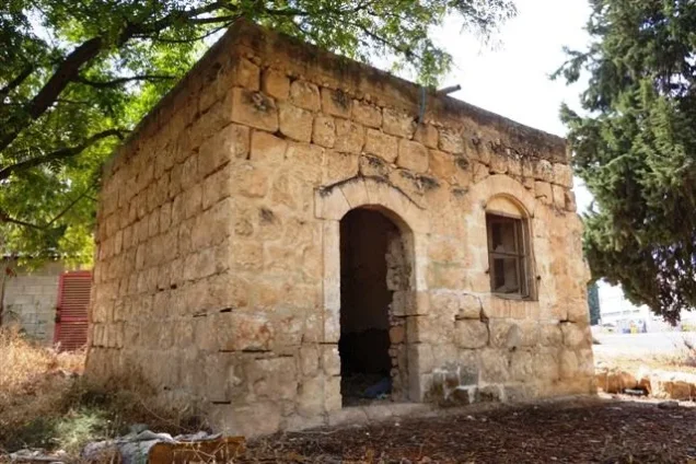
Shrine of al-Nabi Daniyal
The shrine of al-Nabi Daniyal was the village's most prominent religious landmark and remained standing after the village was depopulated.
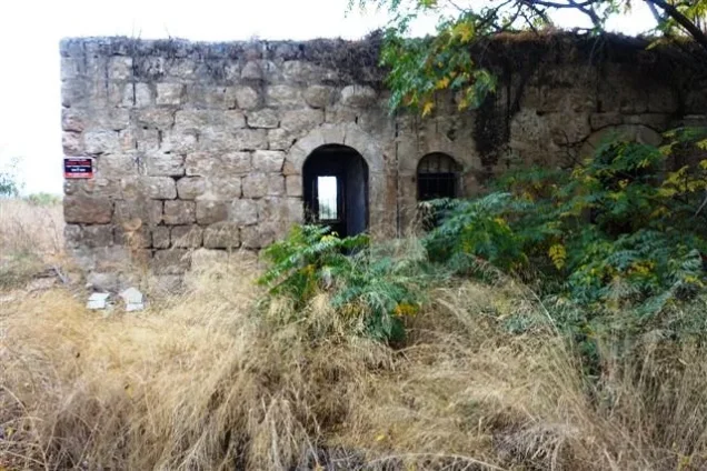
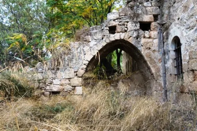
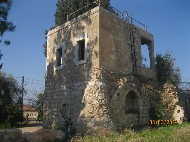
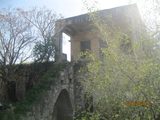
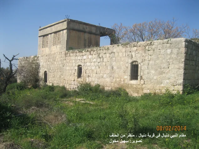
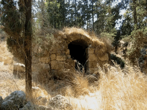
Later fieldwork described it as a stone building with arched doors and windows on the ground floor and a partial upper storey containing a porch and rectangular window.
Local Palestinian documentation also associates a waqf and cemetery with the shrine, although details concerning its administration and associated Sufi tradition derive primarily from local history.
Daniyal before the Nakba
In the late nineteenth century the Survey of Western Palestine described Daniyal as a small settlement clustered around the prophet's shrine.
By the final years of the Mandate, house construction had increased, an elementary school had been established, and several shops stood in the center.
Agriculture nevertheless remained the principal livelihood, with close commercial links to Lydda and Ramla.
Operation Dani
Operation Dani began on 9 July 1948 and ended on 18 July.
It was one of the largest offensives conducted during the Ten Days between the two truces and was intended to expand the Israeli-held corridor toward Jerusalem while capturing Lydda, Ramla, and their hinterland.
The operation unfolded in two stages: the first, from 9 to 12 July, focused on Lydda and Ramla; the second, from 13 to 18 July, extended toward the Ramallah-al-Latrun road.
Daniyal was occupied during the first stage.
Occupation of Daniyal – 10 July 1948
According to the account used by Walid Khalidi, units of the Yiftach Brigade entered Daniyal on 10 July 1948 during the first phase of Operation Dani.
Nearby Jimzu was occupied at the same time because the two villages formed part of the rural approaches protecting the Lydda-Ramla area from the east.
Yiftach forces then continued their advance toward Lydda.
Military Unit
Several brigades participated in Operation Dani at the operational level, including Har'el, Yiftach, Kiryati, Alexandroni, and armored formations.
The village-specific Daniyal account, however, directly identifies the Yiftach Brigade as the force that entered the village.
The other brigades should therefore not automatically be listed as direct participants in Daniyal's occupation.
No village-specific battalion is securely identified in the principal source used here.
Cause of Depopulation
Khalidi states that Daniyal's inhabitants either fled or were expelled during the assault.
The surviving village-level record does not establish how many residents experienced each of these circumstances.
The most accurate formulation is therefore: the 10 July military assault caused the depopulation of Daniyal through flight under attack and/or expulsion as the forces entered.
Destruction: What Is Actually Documented?
Some secondary summaries imply that Daniyal was destroyed on 13 September 1948. The underlying evidence is more limited.
On 13 September, David Ben-Gurion included Daniyal among fourteen villages in a request to a ministerial committee proposing partial demolition.
Khalidi notes that the source he cites does not establish whether that request was implemented or exactly when demolition occurred.
Later fieldwork also demonstrates that the village was not completely erased: the shrine, the school, and seven well-built stone houses survived.
The more accurate formulation is therefore: most of Daniyal's built environment was demolished after depopulation, but the timing and extent of demolition at each stage remain incompletely documented.
Ethnic Cleansing in Source Classification
Palestine Remembered classifies Daniyal using the term “complete ethnic cleansing.” The phrase is retained here only as an attributed source classification.
The more specifically documented facts are the village's occupation by Yiftach forces on 10 July 1948, the flight and/or expulsion of its Palestinian population, absence of permanent collective return, and later destruction of most village buildings.
Occupation Chronology
| Date | Event |
|---|---|
| 9 July 1948 | Operation Dani begins. |
| 10 July 1948 | Yiftach Brigade units enter Daniyal during the first phase of the operation; Jimzu is occupied at approximately the same time. |
| 10 July 1948 | The villagers flee under attack and/or are expelled during the occupation; the village-level record does not resolve the balance between the two. |
| 10–11 July 1948 | Yiftach forces continue toward the Lydda area as Operation Dani advances. |
| 12 July 1948 | Ramla is occupied during the first phase of Operation Dani. |
| 13 September 1948 | Ben-Gurion includes Daniyal among fourteen villages proposed for partial demolition; Khalidi's source does not establish when or whether the request was implemented in that form. |
| Later period | Most village buildings are demolished, while the shrine, school, and seven stone houses survive. |
| 1949 | Kefar Daniyyel is established on the village site. |
Israeli Settlements Established on Daniyal's Lands
Kefar Daniyyel was established in 1949 directly on the site of the depopulated Palestinian village.
This is the post-1948 settlement directly identified by Walid Khalidi and PalQuest on Daniyal's village site.
Daniyal Today
According to the field description used by Walid Khalidi before the publication of All That Remains in 1992, the principal surviving structures were the shrine of al-Nabi Daniyal, the village school, and seven well-built houses.
The abandoned stone shrine stood among weeds and several trees. Its lower floor contained arched doors and windows, while part of the structure rose to a second storey with a porch.
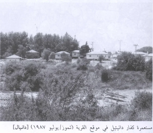
The former school was later used by residents of Kefar Daniyyel.
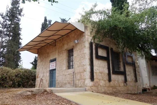
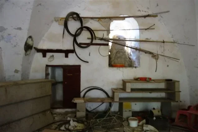
The surviving village houses were built of stone and had flat roofs, with a mixture of arched and rectangular openings. One was used as a warehouse.
Cactus, cypress, olive, Christ's-thorn, and castor-oil plants grew across the village site, while surrounding land was under cultivation.
PalQuest's field photographs date to July 1987. Palestine Remembered also contains later Palestinian community documentation, including photographs from 2014 of surviving village houses and the shrine.
These materials constitute important historical and community documentation but not a comprehensive archaeological or cadastral survey of the entire Daniyal village area in 2026.
Sources
- PalQuest – Interactive Encyclopedia of the Palestine Question: Daniyal
- PalQuest – Operation Dani
- Palestine Remembered – Daniyal, Ramla Subdistrict
- Palestine Remembered – Daniyal entry from Walid Khalidi's All That Remains
- Palestine Encyclopedia – Daniyal, Ramla Subdistrict
- Palestinian Villages Encyclopedia – Daniyal
- Our Palestine – Daniyal, Ramla Subdistrict
Photo gallery





Photos from the village's people
Photos sent in by visitors and published after review.
Add a photo of this village
Log in to add photos of this village.
Other villages from Ramla

More from the archive


 Download Our Palestine App
The whole archive in the palm of your hand: depopulated villages, the Nakba, the massacres and Al-Aqsa — free, with no ads to erase the story.
Download Our Palestine App
The whole archive in the palm of your hand: depopulated villages, the Nakba, the massacres and Al-Aqsa — free, with no ads to erase the story.



Comments
No comments yet — be the first to write one.
Add your comment
Name and email are optional. Comments appear after review.