
The depopulated village of Qula / District of Ramla

About the depopulated village of Qula
- District
- Ramla
- Date Qula was occupied
- 10 July 1948
- Population in 1948
- 1,170
- Brigade that carried it out
- Givati Brigade
- Who defended the village
- Jordanian Army
- Distance from the governorate centre
- 14.5 (km) Northeast of al-Ramla
- Elevation above sea level
- 125 m
- Cause of displacement
- Military assault by Zionist troops
- Extent of destruction
- On September 13th, 1948, Qula was completely obliterated and only house rubble left behind.
- Ethnic cleansing
- Qula inhabitants were completely ethnically cleansed.
Hover a dot to read the village name, or click to open its card.
Borders of the depopulated village of Qula
Qula – Depopulated Palestinian Village of the Ramla Subdistrict
Qula, also locally rendered Quliyya, was a Palestinian village in the Ramla Subdistrict. It stood on a limestone hill on the western slopes of the Ramallah Mountains overlooking the coastal plain, approximately 14.5 km northeast of Ramla and about 125 metres above sea level.
The main road running north from Ramla toward Tulkarm passed approximately 0.5 km west of the village, while several secondary roads connected Qula with neighboring Palestinian communities. Its position at an important road junction north of Lydda gave the village considerable military significance during the Nakba.
Qula had an official population of 1,010 in 1944/45 and registered lands totaling 4,347 dunums. Units of the Alexandroni Brigade and the Eighth Armored Brigade first occupied the village on 10 July 1948 during Operation Dani. Control changed hands repeatedly over the following days before Israeli occupation forces established final control.
Name of Qula
The principal official and Palestinian historical sources use the name Qula, while Quliyya is also widely used in local Palestinian memory and later community documentation.
The village was built on the site of a Crusader fortress known as Cola or Chola, providing the clearest documented historical connection to the locality's name.
Other etymological explanations appear in secondary sources, but none is sufficiently conclusive to be presented as the sole established origin of the name.
Location
Qula stood on a limestone hill at the eastern edge of the central coastal plain and on the western slopes of the Ramallah Mountains, overlooking the plain from an elevation of approximately 125 metres.
The village was about 14.5 km northeast of Ramla.
The Ramla–Tulkarm highway passed approximately 0.5 km to its west, connecting Qula with urban centers, while secondary roads led to surrounding Palestinian villages.
Qula Through History
The village was built on a medieval site containing a Crusader fortress known as Cola or Chola.
In 1596, Qula was recorded in the nahiya of Ramla in the Ottoman liwa' of Gaza with an estimated population of approximately 380.
The villagers paid taxes on goats, beehives, and a press used for processing olives or grapes.
In the late nineteenth century, Qula was described as a village built on a slope at the edge of the plain, with visible remains dating to the medieval period.
Village Layout
Most of Qula's houses were built of adobe and were scattered along a network of roads passing through the village, giving its built-up form a roughly star-shaped pattern.
During the British Mandate, construction increasingly extended alongside the Ramla–Tulkarm highway.
The officially recorded built-up area in 1944/45 was approximately 26 dunums, all in the Arab ownership category.
A mosque, several small shops, and a boys' elementary school stood in the village center.
Population of Qula
- 1596Approx. 380Estimate derived from Ottoman fiscal records.
- 1922480Official Government of Palestine census; the inhabitants were recorded as Muslims.
- 1931697Official census; the population lived in 172 occupied houses.
- 1944/451,010Official Government of Palestine figure.
- 19481,172Later Palestine Remembered estimate, not an official census.
- 19987,195 refugeesLater estimate of refugees originating from Qula and their descendants.
Number of Houses
- 1931172Official Government of Palestine census.
- 1948289Later Palestine Remembered estimate, not an official house count.
Land Ownership in Qula
The registered lands of Qula totalled 4,347 dunums in 1944/45.
Using the ownership terminology employed by Palestine Remembered, the distribution was:
- Palestinian3,885 dunums89%
- Transferred to Zionists271 dunums6%
- Communal/Public191 dunums4%
This corresponds to the official categories of 3,885 Arab dunums, 271 Jewish dunums, and 191 Public dunums.
Land Use in 1944/45
Some simplified online reproductions merge portions of Public land into the Palestinian column. Preserving the official categories gives the following balanced table:
- Arab
- Jewish
- Public
- Cereals3,000 dunums
- Plantations and Irrigable Land105 dunums
- Built-up Area26 dunums
- Non-Cultivable Land1,216 dunums
A total of 3,105 dunums, approximately 71 percent of the village lands, was classified as cultivated or cultivable, while built-up and non-cultivable land totalled 1,242 dunums.
Separate agricultural tables report approximately 460 dunums of olive cultivation. This is a crop-specific indicator and should not be added again to the exhaustive land-use table above, whose categories already reconcile to the total village area.
Economic Life in Qula
Agriculture formed the principal basis of Qula's economy.
The villagers cultivated cereals, vegetables, fruit trees, and olives, with most farming dependent on rainfall.
In 1944/45, 2,842 Arab dunums were devoted to cereals and 105 dunums to plantations and irrigable cultivation.
Orchards were concentrated primarily southeast and southwest of the built-up village.
Several small shops in the village center also served local residents and travelers using the surrounding road network.
Education
A boys' school was founded in Qula in 1919.
By the mid-1940s, approximately 134 pupils were enrolled.
The school became one of the principal surviving landmarks after the destruction of the village.
The Mosque
Qula had a mosque in the village center serving its predominantly Muslim population.
An automated field in one online database also indicates a church, but the detailed Khalidi/PalQuest account does not document one. No church is therefore included among the securely established village institutions without independent evidence.
Archaeological and Historical Remains
Qula was built on the site of a Crusader fortress known as Cola or Chola.
The village also contained remains predating the Ottoman period, while four khirbas were located east of the village.
Later Palestinian community documentation identifies additional archaeological remains, but this article does not automatically assign all surviving structures to a single historical period without specialized archaeological evidence.
Qula Before Operation Dani
Qula's military importance derived from its position at an important road junction north of Lydda, along communications linking the Lydda–Ramla area with the Palestinian highlands and Arab supply lines toward Ramallah and Nablus.
When Operation Dani began on 9 July 1948, Qula lay on the northern side of the offensive whose first objective was the capture of Lydda and Ramla.
First Occupation of Qula – 10 July 1948
Israeli occupation forces first captured Qula on 10 July 1948 after what the source describes as a heated battle.
Khalidi's village-specific account identifies the attacking force as units of the Alexandroni Brigade and the Eighth Armored Brigade.
The capture formed part of the first stage of Operation Dani, whose objectives included surrounding and capturing Lydda and Ramla and expanding Zionist-controlled territory toward Jerusalem.
A New York Times correspondent described Qula at the time as standing at an important crossroads north of Lydda on the Arab supply line between Ramallah and Nablus.
Was the Giv'ati Brigade the Village-Specific Attacking Unit?
An abbreviated Arabic Palestine Remembered field lists the Giv'ati and Armored Brigades.
The detailed Khalidi account, PalQuest, and Palestine Remembered's English entry instead identify the village-specific force as the Alexandroni Brigade and Eighth Armored Brigade.
The broader first stage of Operation Dani also included Alexandroni's Third Infantry Battalion alongside the Eighth Brigade and other formations.
This article therefore does not identify Giv'ati as the documented village-specific force responsible for Qula's first capture.
The Arab Legion Recaptures Qula
Fighting over Qula did not end on 10 July.
On 16 July, an armored column and infantry unit of the Transjordanian Arab Legion briefly recaptured the village. Palestinian historian Aref al-Aref records that three Arab Legion soldiers were killed during the action.
That same afternoon, units of the Israeli Eighth Armored Brigade and two infantry platoons counterattacked and retook Qula.
Another Arab Recapture and the Final Israeli Occupation
On 17 July, Qula again fell into Arab hands.
Alexandroni Brigade units then captured the village once more, after which Israeli occupation forces retained control.
Khalidi's village entry does not provide a separately identified exact date for this final transition. The date of 18 July appearing in some secondary sources should therefore not be treated as definitive without more specific evidence.
The source states that Israeli forces suffered heavy losses during the repeated battles for Qula.
Operation Dani
The battles over Qula took place during Operation Dani, conducted from 9 to 18 July 1948 and described as the largest Israeli offensive during the Ten Days between the two truces.
The operation had two stages. The first, from 9 to 12 July, targeted Lydda and Ramla; the second, from 13 to 18 July, extended toward the Ramallah–Latrun road.
Several brigades participated in the operation, but Qula's village-specific account identifies Alexandroni and the Eighth Armored Brigade in the first capture.
Depopulation of Qula
Qula was depopulated in the context of the military assaults and repeated battles fought over the village during Operation Dani.
Palestine Remembered classifies the cause of departure as direct military assault, while Khalidi's detailed account does not provide a separate moment at which the entire civilian population left or state that all villagers departed in a single event.
The depopulation is therefore placed within the documented sequence beginning with the 10 July attack and continuing through the repeated changes of control over the following days.
On the Claim of a Massacre at Qula
An abbreviated Palestine Remembered field states that a massacre occurred against inhabitants of Qula.
The detailed Khalidi/PalQuest narrative, however, does not describe a separately documented massacre or provide a civilian casualty figure, and the principal Palestinian sources reviewed here do not independently establish such an incident.
This article therefore does not present a Qula massacre as a confirmed historical fact without stronger supporting documentation.
Occupation Chronology
- 9 July 1948
Beginning of Operation Dani
The large offensive began with the objective of seizing the Lydda–Ramla area and expanding control toward Jerusalem.
- 10 July 1948
First occupation of Qula
Alexandroni and Eighth Armored Brigade units captured Qula after a heated battle.
- 16 July 1948
Arab Legion recapture
An armored column and infantry unit of the Arab Legion briefly regained the village.
- Afternoon of 16 July 1948
Israeli counterattack
Eighth Armored Brigade units and two infantry platoons recaptured Qula.
- 17 July 1948
Another Arab recapture
Qula again returned to Arab control.
- After 17 July, during the closing days of Operation Dani
Final Israeli occupation
Alexandroni Brigade units captured Qula again, after which Israeli occupation forces retained control.
- 13 September 1948
Designation for partial destruction
Ben-Gurion included Qula among fourteen villages designated for partial destruction; this is the date of the decision/listing, not independently the date of complete physical destruction.
Hasan Salameh
One of Qula's best-known sons was Palestinian commander Hasan Salameh, a participant in the Palestinian revolt of the 1930s and later commander of the Jaffa–Lydda–Ramla area within the Army of the Holy Jihad during the 1948 war.
Salameh died from wounds sustained in fighting in the Ras al-'Ayn area at the end of May 1948, several weeks before the first occupation of his native village.
Destruction of Qula
On 13 September 1948, Qula was included among fourteen villages designated by Ben-Gurion for partial destruction.
This date should not automatically be described as the day on which the entire village was physically destroyed. The document establishes the destruction designation, while later field documentation records that most village houses had subsequently become ruins.
Israeli Settlements on Qula Village Lands
According to Walid Khalidi and PalQuest, no Israeli settlement was established directly on Qula village land.
Giv'at Koach, founded in 1950 approximately 2 km southwest of Qula, was established on land belonging to the depopulated Palestinian village of al-Tira in the Ramla Subdistrict.
Some secondary sources describe Giv'at Koach as being on or expanding into Qula's lands, but Khalidi's village-specific account places its original establishment on al-Tira land. It is therefore not listed here as a settlement founded on Qula land without additional cadastral evidence.
Qula Today
In the field description published by Walid Khalidi in All That Remains, a forest covered much of the former village site.
Rubble from collapsed houses and ruined terraces lay among the trees, while cactus, fig, mulberry, and eucalyptus grew across the site.
The school building on the western side of the site was the principal surviving landmark documented by Khalidi. Hilly surrounding land was used for grazing while other areas remained under cultivation.
Khalidi's description derives from fieldwork carried out before the publication of All That Remains in 1992 and does not constitute direct and comprehensive verification of the site's condition in 2026.
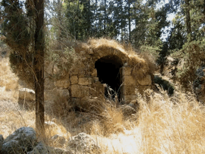
Later Palestinian community documentation, including material published in July 2025, identifies surviving stone remains as parts of Qula's mosque and the Crusader tower. Such material indicates that identifiable archaeological and architectural remains continued to be documented in recent years, but it remains partial community documentation rather than a comprehensive archaeological survey.
Sources
- PalQuest – Qula
- PalQuest – Operation Dani
- Palestine Remembered – Qula, Ramla
- Palestine Remembered – Qula entry from Walid Khalidi's All That Remains
- Palestinian Encyclopedia – Qula
- Census of Palestine 1931 – Palestinian Central Bureau of Statistics digital republication
- Institute for Palestine Studies – Walid Khalidi, All That Remains
Photo gallery


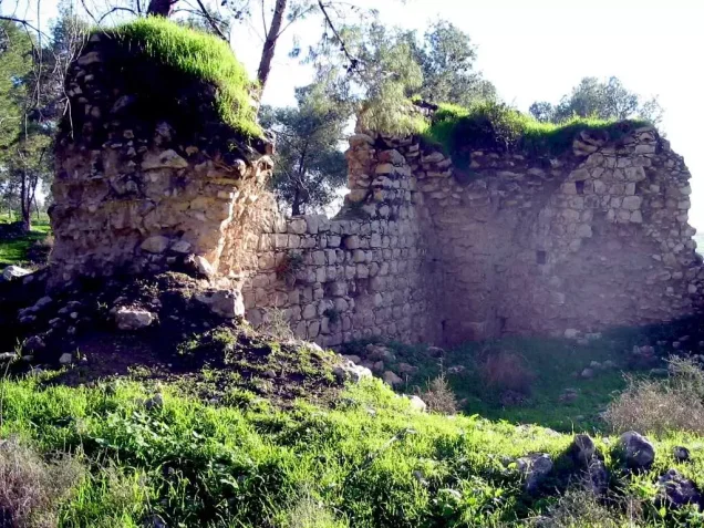

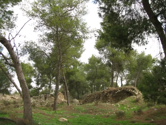


Photos from the village's people
Photos sent in by visitors and published after review.
Add a photo of this village
Log in to add photos of this village.
Other villages from Ramla
More from the archive



 Download Our Palestine App
The whole archive in the palm of your hand: depopulated villages, the Nakba, the massacres and Al-Aqsa — free, with no ads to erase the story.
Download Our Palestine App
The whole archive in the palm of your hand: depopulated villages, the Nakba, the massacres and Al-Aqsa — free, with no ads to erase the story.



Comments
No comments yet — be the first to write one.
Add your comment
Name and email are optional. Comments appear after review.