
The depopulated village of Abu Shusha / District of Ramla
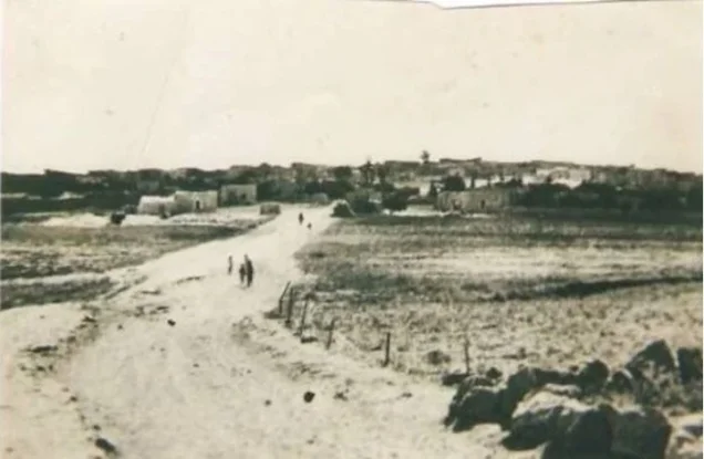
Abu Shusha
About the depopulated village of Abu Shusha
- District
- Ramla
- Date Abu Shusha was occupied
- 14 May 1948
- Population in 1948
- 1,010
- Military operation
- Operation Barak
- Brigade that carried it out
- Givati Brigade
- Who defended the village
- Arab Liberation Army volunteers, and some local Palestinian militia.
- Distance from the governorate centre
- 8.5 (km) Southeast of al-Ramla
- Elevation above sea level
- 200 m
- Cause of displacement
- Military assault by Zionist troops
- Extent of destruction
- Abu Shusha was completely destroyed and defaced.
- Ethnic cleansing
- Abu Shusha inhabitants were completely ethnically cleansed.
- Settlements built on the built-up area of Abu Shusha after 1948
- Ameilim, Pedaya
Hover a dot to read the village name, or click to open its card.
Borders of the depopulated village of Abu Shusha
Abu Shusha: A Depopulated Palestinian Village in the Ramla District
Abu Shusha was a Palestinian village in the Ramla District, located approximately 8.5 km southeast of Ramla on the southern slope of Tall Jazar, where the coastal plain meets the Jerusalem foothills, at an average elevation of about 200 metres above sea level. Its inhabitants were displaced during the Nakba and the occupation of Palestine in 1948. The Giv'ati Brigade occupied the village on 14 May 1948 in the context of Operation Barak after mortar shelling the previous night.
Location of Abu Shusha
Abu Shusha stood on the southern slope of Tall Jazar in the transitional zone where the coastal plain meets the Jerusalem foothills.
The village was approximately 8.5 km southeast of Ramla and had an average elevation of about 200 metres above sea level.
A secondary road linked Abu Shusha with the Jaffa–Jerusalem highway, which passed northeast of the village.
Its lands bordered or lay near those of al-Qubab, al-Barriyya, al-Na'ani, Saydun, and al-Khalayil.
Tall Jazar and the History of the Abu Shusha Site
Abu Shusha occupied the southern slope of Tall Jazar, an important archaeological site identified with the ancient city of Gezer.
Archaeological excavations suggest that the site may have been inhabited as early as the fourth millennium BCE, while artifacts from the third millennium BCE attest to settlement during the Early Bronze Age.
During the Canaanite period, Gezer developed into a fortified city surrounded by walls. It was also listed among the cities captured by the Egyptian pharaoh Thutmose III in the fifteenth century BCE.
The settlement prospered during the Persian and Greek periods. Archaeologists also uncovered a Roman house and lamps dating to the early Christian period.
In Roman times the site was known as Gazara and fell within the administrative jurisdiction of Nicopolis, which occupied the site of the Palestinian village of 'Imwas.
Relatively little is known about Abu Shusha during the early Islamic period.
In 1177, the locality, known to the Crusaders as Mont Gisart, was the scene of a battle between Crusader forces and the army of Salah al-Din al-Ayyubi in which the Crusaders prevailed.
Pottery and coins dating to the thirteenth century indicate continued habitation, while a maqam on the tell appears to have been constructed in the sixteenth century.
Architecture of Abu Shusha
In the early nineteenth century, Abu Shusha consisted of approximately one hundred families living in houses built of stone and mud and surrounded by cactus hedges.
The figure of one hundred refers to families rather than individual inhabitants and should not be used as a nineteenth-century population count.
Later in the nineteenth century, a traveller described Abu Shusha as a very small village.
In modern times, the Palestinian population was entirely Muslim. Houses were built of stone and mud and stood close together.
The village contained a mosque, several shops, and an elementary school.
Education in Abu Shusha
An elementary school was established in Abu Shusha in 1947.
Its initial enrollment was 33 pupils.
Economic Life in Abu Shusha
Agriculture was the principal source of livelihood for the villagers.
Cereal cultivation occupied most of the Palestinian agricultural land, while a much smaller area was irrigated or devoted to plantations.
In 1944/45, 2,475 Palestinian dunums were devoted to cereals and 54 dunums were irrigated or used for plantations.
A further 5,569 dunums in the ownership category “Transferred to Zionists” were used for cereal cultivation.
Land Ownership in Abu Shusha
The total registered land area of Abu Shusha was 9,425 dunums in the 1944/45 statistics.
Land ownership in Abu Shusha, 1944/45, using the terminology of Palestine Remembered
- Palestinian2,896 dunums31%
- Transferred to Zionists6,337 dunums67%
- Communal192 dunums2%
The land recorded in the category “Transferred to Zionists” represented approximately 67.2 percent of Abu Shusha's total registered lands in 1944/45.
Land Use in Abu Shusha, 1944/45
Land use in Abu Shusha, with ownership categories separated according to PalQuest's detailed statistics
- Palestinian
- Transferred to Zionists
- Communal/Public
- Plantations and irrigable land54 dunums
- Cereals8,044 dunums
- Built-up area24 dunums
- Non-cultivable land1,303 dunums
A total of 8,098 dunums, approximately 86 percent of the village lands, was cultivated or cultivable: 2,529 Palestinian dunums and 5,569 dunums in the category “Transferred to Zionists.”
Built-up and non-cultivable land together amounted to 1,327 dunums, approximately 14 percent of the total.
Palestine Remembered presents 535 dunums of non-arable land in its Palestinian column. PalQuest's detailed statistics show that this consists of 343 Arab dunums and 192 public dunums. Another 768 non-cultivable dunums belonged to the category represented here as “Transferred to Zionists.” The communal/public category is therefore shown separately.
Population of Abu Shusha
Population of Abu Shusha in selected years
- Early nineteenth centuryApproximately 100 familiesHistorical description of households, not an individual population count
- 1922603Official British Mandate census
- 1931627Official British Mandate census
- 1944/45870Official statistics; all recorded inhabitants were Arab
- 19481,009Later estimate published by Palestine Remembered
- Estimated refugees in 19986,198Later estimate published by Palestine Remembered
Number of Houses in Abu Shusha
Number of houses in Abu Shusha
- 1931145Official British Mandate census figure
- 1948233Later estimate published by Palestine Remembered
Archaeological Remains at Abu Shusha and Tall Jazar
Abu Shusha and Tall Jazar form one of the area's richest archaeological landscapes.
Excavations uncovered remains from multiple periods, including Bronze Age artifacts, Canaanite fortifications, a Roman house, early Christian lamps, and medieval pottery and coins.
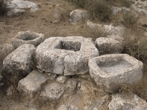
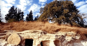
Palestine Remembered also records ruins, rock-cut graves, a well, and nearby Khirbat Dayr Dhakir, which it describes as containing building foundations, caves, and a well. These additional details are attributed specifically to Palestine Remembered because they are not all described at the same level of detail in Khalidi's entry.
The Attack on Abu Shusha, 1 April 1948
Abu Shusha was subjected to an early attack shortly after midnight on 1 April 1948.
Walid Khalidi, citing the History of the Haganah, states that the raid was framed by the Haganah as a retaliatory operation after a guard from nearby Gezer was killed while on Abu Shusha's lands.
Two platoons from the Second Battalion of the Giv'ati Brigade, accompanied by additional forces, infiltrated the village, and demolition experts blew up one house and a well.
Palestinian militia reinforcements arrived from nearby al-Qubab and clashed with the Haganah covering force.
One member of the attacking force was fatally wounded. The cited account does not provide information about Palestinian casualties.
The History of the Haganah is not used independently here; the account is included only because it is reproduced in Khalidi's approved Palestinian reference.
Operation Barak and the Occupation of Abu Shusha
Abu Shusha's final occupation was associated with Operation Barak, conducted primarily by the Giv'ati Brigade against Palestinian villages south and west of Ramla in May 1948.
PalQuest formally lists Operation Barak as running from 9 to 13 May, while its narrative also describes continued operations and a second stage around and after the British withdrawal.
The dedicated Abu Shusha entry explicitly places the village's occupation on 14 May within Operation Barak.
There is therefore a limited internal discrepancy in the dating framework of the operation, but PalQuest explicitly identifies Abu Shusha as one of the villages affected by Operation Barak.
Occupation and Depopulation of Abu Shusha during the Nakba
Giv'ati Brigade units subjected Abu Shusha to mortar fire on the night of 13 May 1948, immediately before the village fell.
Khalidi, citing Israeli historian Benny Morris, gives 14 May 1948 as the occupation date. The History of the Haganah, as reproduced by Khalidi, places the capture one day later, on 15 May.
The account states that the inhabitants fled during the assault and that some village houses were dynamited.
The destruction of part of Abu Shusha was also coordinated with the offensive advancing eastward toward the strategic al-Latrun area. The capture of the village strengthened the position of units participating in Operation Makkabi.
The Israeli sources mentioned above are not used independently; they are included only because they are reproduced and assessed in the approved Palestinian reference.
- Early raid: 1 April 1948.
- Unit in the early raid: two platoons of the Giv'ati Brigade's Second Battalion, with additional forces.
- Mortar shelling: night of 13 May 1948.
- Occupation date favored by Khalidi: 14 May 1948.
- Alternative date in the History of the Haganah: 15 May 1948.
- Military operation: Operation Barak, with an operational connection to the eastward advance associated with Operation Makkabi.
- Occupying unit: Giv'ati Brigade.
- Fate of the inhabitants: the Palestinian population was displaced during the assault and occupation.
The Abu Shusha Massacre
Approved Palestinian sources provide evidence that a massacre occurred at Abu Shusha in the course of the village's occupation in 1948.
In a 2022 study published by the Institute for Palestine Studies in Jerusalem Quarterly, historian Salim Tamari describes Tall Jazar as the site of a documented massacre carried out by the Haganah against the villagers of Abu Shusha during the 1948 occupation of Palestine.
Palestine Remembered also classifies the events at Abu Shusha as a massacre, while later articles and testimonies provide differing estimates of the number of victims.
Khalidi's principal village entry in All That Remains, however, does not provide a casualty total, and later numerical estimates are not consistent. This article therefore records the massacre on the basis of the Institute for Palestine Studies documentation without assigning a definitive death toll.
Settlements Established on the Lands of Abu Shusha
Two settlements are identified as having been established directly on the village site or its lands after the Nakba:
- Ameilim: established in 1948 on the site of the destroyed village.
- Pedaya: established in 1951 on Abu Shusha's lands near the boundary with the lands of the depopulated village of al-Na'ani.
Gezer, established on 13 March 1945 immediately north of Abu Shusha, stood nearby but was built on land belonging to al-Qubab rather than Abu Shusha.
Petachya and Beyt 'Uzzi'el are also nearby but are explicitly identified by Khalidi as not being on Abu Shusha's lands.
Abu Shusha Today
According to the field description published by Walid Khalidi in All That Remains, the settlement of Ameilim occupied most of the former village site.
Fig and cypress trees, cactus plants, and a single palm tree grew on the site.
The surrounding valleys were planted with apricot and fig trees, while various fruit trees were cultivated on the surrounding heights.
Palestine Remembered contains later aerial photographs, oral histories, and user-contributed filmed visits to Abu Shusha and Tall Jazar. These materials, however, do not constitute a comprehensive independent field survey of the entire village site.
The principal description above therefore relies on Khalidi's field research published in 1992. The approved sources used here do not provide a sufficiently comprehensive and independent contemporary survey to verify the precise condition of every part of Abu Shusha in 2026.
Sources
- PalQuestPalQuest – Interactive Encyclopedia of the Palestine Question: Abu Shusha, Ramla District
- PalQuestPalQuest – Operation Barak
- Palestine RememberedPalestine Remembered – Abu Shusha, Ramla District
- Institute for Palestine StudiesInstitute for Palestine Studies – Salim Tamari, Archaeology, Historical Memory, and Peasant Resistance: The Gezer Excavations at Abu Shusha
- Institute for Palestine StudiesInstitute for Palestine Studies – All That Remains, Walid Khalidi
Photo gallery


Photos from the village's people
Photos sent in by visitors and published after review.
Add a photo of this village
Log in to add photos of this village.
Other villages from Ramla
More from the archive
 Download Our Palestine App
The whole archive in the palm of your hand: depopulated villages, the Nakba, the massacres and Al-Aqsa — free, with no ads to erase the story.
Download Our Palestine App
The whole archive in the palm of your hand: depopulated villages, the Nakba, the massacres and Al-Aqsa — free, with no ads to erase the story.



Comments
No comments yet — be the first to write one.
Add your comment
Name and email are optional. Comments appear after review.