
The depopulated village of Al-Nabi Rubin / District of Ramla
Al-Nabi Rubin
About the depopulated village of Al-Nabi Rubin
- District
- Ramla
- Date Al-Nabi Rubin was occupied
- 01 June 1948
- Population in 1948
- 1,650
- Military operation
- Operation Barak
- Brigade that carried it out
- Givati Brigade
- Distance from the governorate centre
- 14.5 (km) West of al-Ramla
- Elevation above sea level
- 25 m
- Cause of displacement
- Expulsion by Zionist troops
- Extent of destruction
- The village was mostly destroyed with the exception of the village shrine and its mosque.
- Ethnic cleansing
- Some villagers managed to stay behind until the end of the harvest time, then they were kicked out.
- Settlements built on the built-up area of Al-Nabi Rubin after 1948
- Palmachim, Gan Soreq
Hover a dot to read the village name, or click to open its card.
Borders of the depopulated village of Al-Nabi Rubin
Al-Nabi Rubin – Depopulated Palestinian Village in Ramla Subdistrict
Al-Nabi Rubin was a Palestinian village in the Ramla subdistrict, situated on the southern bank of the Rubin River in the central coastal plain. It lay approximately 14.5 kilometers west of al-Ramla and about 3 kilometers from the Mediterranean coast, at an average elevation of approximately 25 meters above sea level.
The village occupied a distinctive place in Palestinian religious and social life because of the shrine of al-Nabi Rubin and its famous annual mawsim, which attracted thousands of visitors from Jaffa, Lydda, Ramla, and surrounding villages. Al-Nabi Rubin also possessed one of the largest registered village land areas in the Ramla subdistrict, totaling 31,002 dunums in 1944/45.
During the Nakba and the 1948 occupation of Palestine, the village's capture was associated with the second stage of Operation Barak, carried out principally by the Giv'ati Brigade. Walid Khalidi, citing an Israeli source he discusses, records that the villagers were expelled on 1 June 1948.
Key Facts about Al-Nabi Rubin
| Field | Information |
|---|---|
| Name | Al-Nabi Rubin |
| Subdistrict | Ramla |
| Status | Depopulated Palestinian village |
| Distance from al-Ramla | Approximately 14.5 km west |
| Distance from the Mediterranean | Approximately 3 km |
| Average elevation | Approximately 25 m above sea level |
| Population, 1944/45 | 1,420 – official Mandatory statistics |
| Registered land area | 31,002 dunums |
| Military operation | Second stage of Operation Barak |
| Military unit | Giv'ati Brigade |
| Date of expulsion | 1 June 1948 |
| Cause of depopulation | Direct expulsion of the residents |
| Settlements on village lands | Palmachim (1949) and Gan Soreq (1950) |
Location of Al-Nabi Rubin
Al-Nabi Rubin stood on the southern bank of the Rubin River near its outlet to the Mediterranean Sea. Its lands extended over a broad zone of coastal sand dunes and constituted the second-largest registered village land area in the Ramla subdistrict after Yibna.
Yibna lay to the southeast and Wadi Hunayn to the east, while the village's lands extended westward toward the Mediterranean coast. The wider area formed part of the coastal landscape between Jaffa, Ramla, and Yibna.
The Name and Shrine of Al-Nabi Rubin
The village took its name from the shrine of al-Nabi Rubin. Palestinian religious tradition associated Rubin, or Reuben, with one of the sons of Jacob. This identification belongs to religious tradition and should not in itself be treated as archaeological proof of the identity of the person commemorated at the shrine.
Walid Khalidi records a belief that the shrine stood on the site of an earlier Canaanite temple and that the mawsim had older origins. These statements remain qualified historical interpretations in the source rather than conclusively demonstrated archaeological facts.
The Mawasim of Al-Nabi Rubin
The annual mawsim of Al-Nabi Rubin was one of Palestine's best-known popular and religious festivals, together with the mawsim of al-Nabi Musa. It generally lasted through the summer, from July to September.
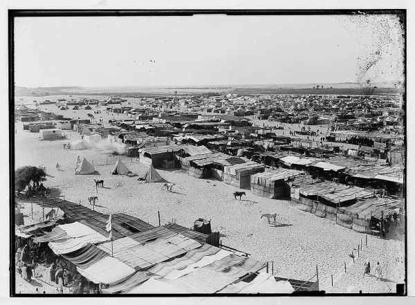
Visitors came from Jaffa, Lydda, Ramla, and surrounding villages, establishing a temporary tent city around the shrine. Activities included dhikr gatherings, religious and popular songs, dabka dancing, horse races, sermons, zajal poetry, entertainment, and temporary markets.
Makeshift cafés, restaurants, and stalls served visitors and created a substantial seasonal economy. Historical photographs reproduced in Khalidi's documentation show that the temporary encampment could accommodate tens of thousands of participants during major festivals.
Al-Nabi Rubin before the Nakba
The village inhabitants belonged to the Abu Sawayrih tribe, whom Walid Khalidi connects with the al-Maliha Bedouin community formerly living in Sinai. Houses were scattered across a large area rather than concentrated in a compact village nucleus, and some were built within fruit orchards.
Much of Al-Nabi Rubin's land consisted of sand dunes and was classified as Islamic waqf land. Nevertheless, wells, springs, and groundwater supported agriculture and orchards in suitable areas.
Shops and a cinema were built near the shrine to serve villagers and visitors, reflecting the economic and social importance of the annual mawsim.
Population of Al-Nabi Rubin
- 1922120Official census; recorded as the Nabi Rubin tribal area, all Muslims
- 1944/451,420Official Government of Palestine statistics; all classified as Arab
- 19481,647Later estimate reported by Palestine Remembered, not an official census
- 199810,116 refugeesLater estimate of refugees and descendants reported by Palestine Remembered
The principal sources reviewed do not provide a sufficiently clear separate 1931 population or house count for Al-Nabi Rubin to justify inserting an uncertain figure.
The 1948 and 1998 figures must not be described as figures from the 1945 Mandatory Village Statistics even though Palestine Remembered places a general reference to those statistics below its population table. Both are necessarily later estimates.
Land Ownership in Al-Nabi Rubin
The registered land area of Al-Nabi Rubin in the 1944/45 statistics totaled 31,002 dunums, making it one of the largest village land areas in the Ramla subdistrict.
- Palestinian30,994 dunums100%
- Transferred to Zionists0 dunums0%
- Communal/Public8 dunums<1%
This corresponds with the official categories: 30,994 Arab dunums and 8 Public dunums, with no land recorded in the Jewish ownership category.
Land Use in 1944/45
- Arab
- Public
- Cereals4,357 dunums
- Plantations and irrigable land184 dunums
- Citrus and bananas683 dunums
- Non-cultivable land25,778 dunums
The figures balance correctly: 4,357 + 184 + 683 + 25,778 = 31,002 dunums.
PalQuest does not display a separate built-up acreage for Al-Nabi Rubin, so no unsupported built-up figure has been added. The figure of 5,224 dunums sometimes shown as “cultivable” is the combined total of cereals, plantations and irrigable land, and citrus and bananas; it is not an additional category to be added again.
Economic Life in Al-Nabi Rubin
The villagers depended on agriculture and animal husbandry, together with economic activities associated with the annual mawsim.
Cereals were the leading crop, occupying 4,357 dunums in 1944/45. Citrus and bananas covered 683 dunums, while 184 dunums were irrigated or used for plantations. Other fruit crops included figs and grapes.
The annual festival also provided seasonal income through food sales, cafés, restaurants, stalls, and services for thousands of visitors.
Water Resources
Al-Nabi Rubin obtained water from several wells and springs in addition to its proximity to the Rubin River. These resources supported orchards and cultivation in portions of the otherwise sandy landscape.
Eucalyptus and chinaberry trees grew along the river bank and covered portions of village land.
Education in Al-Nabi Rubin
A boys' elementary school was established in Al-Nabi Rubin in 1946. According to Walid Khalidi, approximately 56 pupils attended the school in the mid-1940s.
Palestine Remembered separately reports 55 pupils in 1945, but this date precedes Khalidi's documented founding date of 1946. The Khalidi account is therefore retained here, with the discrepancy left explicit rather than silently reconciled.
Mosque and Shrine
The shrine of al-Nabi Rubin and its associated mosque were the village's most prominent religious and architectural landmarks. Historical photographs show the mosque, minaret, shrine, and courtyards used during the annual mawsim.
The principal sources reviewed do not provide reliable documentation of a church in Al-Nabi Rubin, and the church entry appearing in an automated Palestine Remembered table has therefore not been treated as a verified village institution.
Manarat Rubin and Archaeology
At the far southwestern edge of the village lands stood Manarat Rubin, the “Lighthouse of Reuben,” constructed over the ruins of the ancient port of Yibna, known in Roman times as Iamnitarum Portus.
Walid Khalidi records excavations that uncovered a roughly square beaten-earth rampart measuring approximately 800 meters on each side and dating to the second millennium BCE.
These archaeological remains should be distinguished from religious traditions concerning the shrine. The traditional identification of the shrine's occupant is not equivalent to archaeological confirmation of the person's identity.
Operation Barak
Operation Barak was a Haganah campaign directed primarily at the area south and west of Ramla. Most of the operation was carried out by the Giv'ati Brigade under Shim'on Avidan, while the Palmach's Negev Brigade operated on another axis.
PalQuest contains an internal chronological inconsistency in its Operation Barak entry: the summary fields give 9–13 May 1948, while the detailed narrative states that a second stage began after the British withdrawal on 15 May and that operations continued through the end of the month.
Al-Nabi Rubin's association with the “second stage of Operation Barak” therefore derives from the detailed historical narrative reproduced by Khalidi and should not be interpreted as meaning that the village necessarily fell between 9 and 13 May.
Occupation and Depopulation of Al-Nabi Rubin
Walid Khalidi states that circumstantial evidence indicates Al-Nabi Rubin was occupied during the second stage of Operation Barak. His village entry does not provide an independently established date for the first military entry into the village.
The more firmly dated event is the expulsion of the villagers on 1 June 1948. Khalidi cites an Israeli source he discusses for this date and notes that the expulsion occurred three days before the residents of neighboring Yibna were forced from their homes.
Khalidi connects the expulsion with the practices of the Giv'ati Brigade under Shim'on Avidan in the context of Plan Dalet. Giv'ati can therefore be identified as the military formation directly associated with Al-Nabi Rubin's capture and expulsion, while preserving the distinction between the circumstantial dating of occupation and the specifically reported date of expulsion.
Palestine Remembered classifies the villagers' departure as direct expulsion by Zionist forces and describes the complete removal of the community as ethnic cleansing. In directly documented descriptive terms, the Palestinian inhabitants were forcibly removed from Al-Nabi Rubin on 1 June 1948 and were not allowed to reconstitute their community in the village.
Occupation Chronology
- May 1948
Beginning of Operation Barak
The Giv'ati Brigade began a campaign against villages south and west of Ramla in the context of Plan Dalet.
- From mid-May 1948 according to PalQuest's detailed narrative
Second stage of Operation Barak
Operations continued after 15 May, and Khalidi associates Al-Nabi Rubin's occupation with this stage.
- During the second stage of Operation Barak; exact first-entry date not independently established
Occupation of Al-Nabi Rubin
Khalidi explicitly describes the evidence for the occupation stage as circumstantial.
- 1 June 1948
Final expulsion
The inhabitants were expelled; Khalidi connects the action with Giv'ati Brigade practices under Shim'on Avidan.
- Approximately 4 June 1948
Expulsion of neighboring Yibna
Khalidi states that Al-Nabi Rubin's inhabitants were expelled three days before those of Yibna.
- Precise date not established in the principal sources reviewed
Destruction
Most village structures were destroyed, while the shrine, mosque, and a limited number of other structures survived for varying periods.
Israeli Settlements on Al-Nabi Rubin's Lands
Two Israeli settlements were established on Al-Nabi Rubin's lands after the Nakba:
| Settlement | Established | Relationship to Al-Nabi Rubin |
|---|---|---|
| Palmachim | 1949 | Established on the coastal lands of Al-Nabi Rubin, south of the mouth of the Rubin River |
| Gan Soreq | 1950 | Established on village land approximately 3.5 km west of the shrine |
Al-Nabi Rubin Today
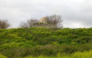
In Walid Khalidi's field description, the shrine of al-Nabi Rubin remained standing amid shrubs and wild vegetation, together with several smaller stone shrines and a detached cement structure near the main shrine.
Field photographs from 1987 showed the mosque and its minaret still standing. A Palestine Remembered caption, however, states that the minaret collapsed in 1991. Khalidi's original description should therefore not be repeated as though the minaret necessarily remains in the same condition today.
Palestine Remembered also contains later community documentation labeled 2005, 2012, and subsequent years showing the shrine and mosque complex. These materials indicate the continued survival of parts of the religious site after Khalidi's fieldwork, but they do not constitute a comprehensive independent field survey of all Al-Nabi Rubin lands or their condition in 2026.
Sources
- PalQuest – Interactive Encyclopedia of the Palestine Question: Al-Nabi Rubin, Ramla
- PalQuest – Operation Barak
- Palestine Remembered – Al-Nabi Rubin, Ramla District
- Walid Khalidi – All That Remains: Al-Nabi Rubin
- Official Census of Palestine, 1922
- Village Statistics 1945 – Ramle Sub-District: Population and Land Ownership
- Village Statistics 1945 – Ramle Sub-District: Land Use
- Institute for Palestine Studies – All That Remains, Walid Khalidi
Photo gallery


Photos from the village's people
Photos sent in by visitors and published after review.
Add a photo of this village
Log in to add photos of this village.
Other villages from Ramla

More from the archive


 Download Our Palestine App
The whole archive in the palm of your hand: depopulated villages, the Nakba, the massacres and Al-Aqsa — free, with no ads to erase the story.
Download Our Palestine App
The whole archive in the palm of your hand: depopulated villages, the Nakba, the massacres and Al-Aqsa — free, with no ads to erase the story.



Comments
No comments yet — be the first to write one.
Add your comment
Name and email are optional. Comments appear after review.