
The depopulated village of Dayr Muhaysin / District of Ramla
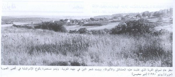
Dayr Muhaysin
About the depopulated village of Dayr Muhaysin
- District
- Ramla
- Date Dayr Muhaysin was occupied
- 06 April 1948
- Population in 1948
- 534
- Military operation
- Operation Nachshon
- Distance from the governorate centre
- 12 كم جنوب شرقي الرملة
- Elevation above sea level
- 150 m
- Cause of displacement
- Military assault by Zionist troops
- Extent of destruction
- Dayr Muhaysin was completely defaced, and only house rubble left behind.
- Ethnic cleansing
- Early April 1948, Dayr Muhaysin was completely ethnically cleansed.
- Settlements built on the built-up area of Dayr Muhaysin after 1948
- بكواع
Hover a dot to read the village name, or click to open its card.
Borders of the depopulated village of Dayr Muhaysin
Dayr Muhaysin – Depopulated Palestinian Village of the Ramla Subdistrict
Dayr Muhaysin was a Palestinian village in the Ramla Subdistrict, approximately 12 kilometers southeast of Ramla. It stood on a relatively level, elongated hill running north to south at an average elevation of about 150 meters above sea level.
The village lay close to an important transportation corridor. A spur connected it with the road linking Gaza to the Ramla–Jerusalem highway, which passed approximately 200 meters south of the village, while dirt roads connected Dayr Muhaysin with neighboring Palestinian localities.
- Subdistrict
- Ramla
- Distance from Ramla
- Approximately 12 km southeast
- Average Elevation
- Approximately 150 meters
- Population in 1931
- 113
- Occupied Houses in 1931
- 28
- Population in 1944/1945
- 460
- Estimated Population in 1948
- Approximately 534 – later demographic estimate, not an official census
- Total Land Area
- 10,008 dunums
- First Assault / Capture
- Early April 1948; Palestinian reference sources differ between 3, 5, and 6 April
- Temporary Withdrawal
- Haganah forces temporarily withdrew following a British request
- Final Reoccupation
- Before 15 May 1948; precise date not documented
- Military Operation
- Operation Nachshon
- Military Force
- Haganah; Har'el and Giv'ati participated at operation level, but the village-specific brigade or battalion is not conclusively identified
- Cause of Displacement
- Military assault and fighting during Operation Nachshon
- Extent of Destruction
- Extensive or near-total destruction and leveling; no documented numerical percentage
- Post-1948 Settlement
- Beqoa' – established in 1951 on village land
Location
Dayr Muhaysin occupied a level and relatively elongated rise running from north to south.
A short road linked it to the highway connecting Gaza with the Ramla–Jerusalem road, which passed only about 200 meters south of the built-up area.
Its location near the route between the coastal plain and Jerusalem became particularly important during the fighting of 1948.
Names and Earlier History of the Site
Dayr Muhaysin was also known as Umm al-Shukf.
Historical sources associate the site with the Crusader-period name Deirmusim.
In the late nineteenth century, the Survey of Western Palestine described a large site containing remains of abandoned dwellings, together with older archaeological features including cisterns and caves.
The Built-up Village before the Nakba
The modern village houses were built of masonry along roads radiating from the center.
As the village expanded, houses increasingly extended toward the major road passing to the south.
The residents maintained a mosque and several shops.
Population in 1931
The official 1931 Census of Palestine recorded 113 inhabitants in Dayr Muhaysin living in 28 occupied houses.
- 193111328
Population in 1944/1945
The village population had increased to 460 by 1944/45 according to official statistics.
This represents substantial growth from the 1931 census figure.
Estimated Population in 1948
Palestinian databases drawing on Salman Abu Sitta's demographic estimates give approximately 534 inhabitants for Dayr Muhaysin in 1948.
This figure should be clearly distinguished from the official 1945 total: 534 is a later estimate for the population on the eve of the Nakba and was not produced by an official 1948 census.
- 1931113Official Census of Palestine
- 1944/1945460Official statistics
- 1948534Later demographic estimate
Land Ownership in 1945
Dayr Muhaysin had a total land area of 10,008 dunums.
The official Mandate categories were Arab, Jewish, and Public. No land was recorded in the Jewish category.
- Palestinian9,704 dunums97%
- Transferred to Zionists0 dunums0%
- Communal/Public304 dunums3%
In the original Mandate terminology, the categories were 9,704 Arab dunums, zero Jewish dunums, and 304 public dunums.
Land Use in 1945
- Cereals7,909 dunums44%
- Plantations and Irrigable Land45 dunums<1%
- Total Cultivable / Cultivated Land7,954 dunums44%
- Built-up Area72 dunums<1%
- Non-Cultivable Land1,982 dunums11%
The totals reconcile exactly with the village's overall land area.
Economic Life
Dayr Muhaysin depended primarily on rain-fed agriculture.
Cereals were cultivated on the lower and flatter lands, while fruit trees were planted on the slopes.
The principal agricultural products included:
- Cereals.
- Olives.
- Grapes.
- Figs.
- Almonds.
Cultivated or cultivable land accounted for close to four-fifths of the village's total land area.
Mosque and Shops
The village had a mosque and several shops serving the local population.
The principal sources reviewed for this article do not provide sufficiently firm evidence for a separate village school, so none is added without direct documentation.
Dayr Muhaysin and the Road to Jerusalem
Dayr Muhaysin's position near the Khulda–Jerusalem corridor made it an early target in the spring of 1948.
On the night of 31 March–1 April, the Haganah leadership decided to launch a special operation to take control of villages along the route linking the coastal plain with Jerusalem.
This became Operation Nachshon, whose goal was to open and secure the Tel Aviv–Jerusalem road.
Operation Nachshon
Operation Nachshon began in early April 1948 within the broader framework of Plan Dalet.
Large Haganah and Palmach forces were mobilized, with operational orders treating Arab villages along the Khulda–Jerusalem axis as hostile assembly points or potential attack bases.
PalQuest explicitly lists Dayr Muhaysin among the villages affected by Operation Nachshon.
Disagreement over the First Capture Date
The Palestinian sources used here do not provide one completely consistent date for Dayr Muhaysin's first capture.
| Source | Date Given |
|---|---|
| PalQuest village entry | 3 April 1948 |
| PalQuest overall chronology | 5 April 1948 |
| Khalidi-derived Palestine Remembered entry | 6 April 1948 |
Because of this discrepancy, the most careful formulation is “early April 1948” for the first capture, while 6 April remains the date most commonly reproduced in Palestinian village databases.
Fighting at Dayr Muhaysin
Khalidi reports that the History of the Haganah characterized the village's capture as relatively easy.
A British military communiqué cited in the same account, however, stated that fighting continued until nightfall.
Arab forces subsequently attempted twice to retake the village but failed to establish lasting control.
Temporary Haganah Withdrawal
After the first capture, British forces stationed at Latrun intervened.
They asked the Haganah to leave Dayr Muhaysin because the nearby road was important to British military supply lines.
The Haganah temporarily withdrew after receiving assurances regarding British convoy security.
Reoccupation of Dayr Muhaysin
The exact date on which Haganah forces returned after the temporary withdrawal is not documented.
Walid Khalidi considers it most likely that reoccupation occurred soon afterward and in any case before 15 May 1948.
Accordingly, 3, 5, or 6 April should not automatically be described as the village's final occupation date. Those dates refer to the first capture, which was followed by a temporary withdrawal and later reoccupation.
Occupation Chronology
- Night of 31 March–1 April 1948
Operational Decision
Haganah leadership decided to launch an operation against villages along the coastal plain–Jerusalem corridor.
- Early April 1948
Beginning of Operation Nachshon
The operation sought to open and secure the Jerusalem road.
- 3–6 April 1948 depending on source
First Capture of Dayr Muhaysin
Haganah forces attacked and gained control during the opening stage of Operation Nachshon.
- Following days
Arab Counterattacks
Arab forces twice attempted to recover the village but did not retain it.
- Early April 1948
Temporary Haganah Withdrawal
British forces requested evacuation of the village because of its importance to their military supply route.
- After the British-requested withdrawal and before 15 May 1948
Final Reoccupation
Haganah forces returned; the precise date is unknown.
Military Operation and Unit
Military Operation: Operation Nachshon.
Military Force: Haganah.
PalQuest lists the Har'el and Giv'ati brigades among the forces participating in Operation Nachshon as a whole, together with Haganah and Palmach formations.
The village sources, however, do not conclusively identify which brigade or battalion specifically entered Dayr Muhaysin. Neither Giv'ati nor Har'el should therefore be assigned as the village-specific executing unit without stronger direct evidence.
Cause of Displacement
The immediate cause of Dayr Muhaysin's depopulation was military assault and fighting associated with Operation Nachshon.
Khalidi's account indicates that villagers left before or during the Haganah assault amid military operations directed against communities along the Jerusalem-road corridor.
“Military assault” is therefore the most supportable description without imposing one unsupported narrative on every family's departure.
Destruction
Khalidi's account states that Dayr Muhaysin was apparently leveled soon after its capture, in a pattern similar to other villages taken during Operation Nachshon.
The post-Nakba site description confirms that the village area was bulldozed and substantially flattened.
The destruction can therefore be described as extensive or near-total, although no reliable numerical destruction percentage is documented.
Post-1948 Settlement on Village Land
Beqoa' was established in 1951 on Dayr Muhaysin village land.
It lies in the northwestern part of the historical village area.
Dayr Muhaysin Today
The available site description derives primarily from the historical field research incorporated into Walid Khalidi's All That Remains and should not be treated as a comprehensive direct field verification for 2026.
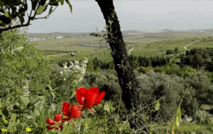
According to that description, the village site had been bulldozed and leveled and was largely covered by wild vegetation.
Almond, mulberry, and pomegranate trees grew on the site, while a row of fig trees remained along its western side.
Beqoa', established in 1951, lies on village land northwest of the former built-up site.
Sources
- PalQuest – Interactive Encyclopedia of the Palestine Question: Dayr Muhaysin
- PalQuest – Operation Nachshon
- PalQuest – Overall Chronology: Operations Nachshon and Har'el
- Institute for Palestine Studies – Walid Khalidi, All That Remains
- Palestine Remembered – Dayr Muhaysin entry from All That Remains
- Palestine Remembered – Dayr Muhaysin: Population, Land Ownership, and Land Use
Photos from the village's people
Photos sent in by visitors and published after review.
Add a photo of this village
Log in to add photos of this village.
Other villages from Ramla
More from the archive



 Download Our Palestine App
The whole archive in the palm of your hand: depopulated villages, the Nakba, the massacres and Al-Aqsa — free, with no ads to erase the story.
Download Our Palestine App
The whole archive in the palm of your hand: depopulated villages, the Nakba, the massacres and Al-Aqsa — free, with no ads to erase the story.



Comments
No comments yet — be the first to write one.
Add your comment
Name and email are optional. Comments appear after review.