
The depopulated village of Al Qubab / District of Ramla
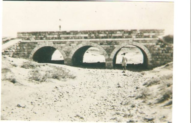
Al Qubab
About the depopulated village of Al Qubab
- District
- Ramla
- Date Al Qubab was occupied
- 15 May 1948
- Population in 1948
- 2,297
- Military operation
- Operation Yiftach
- Brigade that carried it out
- Haganah
- Distance from the governorate centre
- 10 (km) Southeast of al-Ramla
- Elevation above sea level
- 150 m
- Cause of displacement
- Military assault by Zionist troops
- Extent of destruction
- On September 13th, 1948, al-Qubab was mostly destroyed with the exception of the its school and few houses remain standing.
- Ethnic cleansing
- al-Qubab inhabitants were completely ethnically cleansed.
- Settlements built on the land of Al Qubab before 1948
- Gezer
- Settlements built on the built-up area of Al Qubab after 1948
- Mishmar Ayalon, Kfar Bin Nun
Hover a dot to read the village name, or click to open its card.
Borders of the depopulated village of Al Qubab
al-Qubab – Ramla Subdistrict
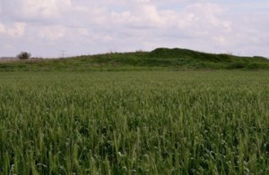
Al-Qubab was a depopulated Palestinian village in the Ramla subdistrict, located approximately 10 km southeast of al-Ramla at an average elevation of about 150 meters. The village was built on several dome-shaped hills north of the Ramla–Jerusalem highway, and its name, meaning “the domes,” was probably derived from the shape of those hills.
The official 1931 Census of Palestine recorded 1,502 inhabitants, and the 1944/45 statistics recorded 1,980. The village lands covered 13,918 dunums. Al-Qubab experienced more than one phase of military occupation in 1948: one account records a Haganah capture on 15 May, while another places its capture by the Yiftach Brigade in early June during the battles over al-Latrun. The discrepancy strongly suggests that control was unstable during the first weeks.
Location of al-Qubab
Al-Qubab stood in the transitional zone between the central coastal plain to the west and the uplands to the east. It belonged to a cluster of villages known as the 'irqiyyat, or “small-hill villages.”
The houses occupied several rocky, dome-shaped hills immediately north of the Ramla–Jerusalem highway, one of Palestine's major transportation routes.
Its location connected al-Qubab with al-Ramla, Jaffa, Jerusalem, and the al-Latrun area, while local roads linked it with surrounding villages.
Boundaries and Neighboring Villages
Palestinian local documentation describes the surrounding village lands approximately as follows:
| Direction | Neighboring village / land |
|---|---|
| North | Bayt Shanna, al-Kunayyisa, and 'Innaba |
| Northwest | al-Biriyya |
| West | Abu Shusha / Tall Jazar |
| South | al-Khalayil |
| Southeast | al-Latrun and 'Imwas |
| East | Salbit |
These directions are useful for describing the geographical and cadastral setting, although original Mandate land maps remain the strongest source for tracing exact parcel boundaries.
Name and Historical Background
The name al-Qubab most likely referred to the dome-shaped hills on which the village was built.
The Jerusalem chronicler Mujir al-Din al-Hanbali recorded al-Qubab as a village under the jurisdiction of al-Ramla in 1493.
Its location between the coastal plain and the hills also explains its classification among the villages known locally as the 'irqiyyat.
al-Qubab in the Late Nineteenth Century
The Survey of Western Palestine described al-Qubab in the late nineteenth century as an adobe-built village on rising rocky ground surrounded by olive groves and cactus hedges.
Later houses were built of mud and stone and clustered closely together along narrow lanes.
As its population increased, al-Qubab became one of the larger villages in the eastern part of the Ramla subdistrict.
Population of al-Qubab
- 19221,275Official Census of Palestine; all enumerated inhabitants were Muslims
- 19311,502Official Census of Palestine; 709 males and 793 females, all Muslims
- 1944/451,980Official British Mandate-era statistics
- 19482,297Later estimate published by Palestine Remembered; not an official census
- 199814,105 refugees and descendantsLater demographic estimate published by Palestine Remembered
Number of Houses
- 1931382Official Census of Palestine
- 1948584Later estimate published by Palestine Remembered; not an official census figure
Land Ownership
Al-Qubab's registered lands totaled 13,918 dunums in the 1944/45 statistics. Palestine Remembered presents the simplified ownership categories as follows:
- Palestinian12,668 dunums91%
- Transferred to Zionists861 dunums6%
- Communal/Public389 dunums3%
PalQuest preserves the official categories: 12,668 dunums Arab, 861 dunums Jewish, and 389 dunums Public.
Land Use in 1944/45
- Arab
- Jewish
- Public
- Cereals13,169 dunums
- Plantations and irrigable land238 dunums
- Built-up land54 dunums
- Non-cultivable land457 dunums
This table corrects an important presentation problem in Palestine Remembered. Its Palestinian cereal figure of 12,308 dunums combines 12,295 Arab dunums with 13 Public dunums.
Similarly, the 457 dunums of non-cultivable land were not all privately Palestinian-held: they consisted of 81 Arab dunums and 376 Public dunums.
Palestine Remembered separately records approximately 296 dunums planted with olives. This is a crop-specific figure within the broader agricultural categories and should not be added again to the total land-use calculation.
Economic Life in al-Qubab
Agriculture and animal husbandry were the principal sources of livelihood. The inhabitants cultivated cereals, vegetables, fruit, and olives and benefited from the village's transitional location between the plain and the uplands.
In 1944/45, 12,295 Arab dunums were devoted to cereals and 238 dunums were classified as plantations or irrigable land.
The village also contained a marketplace with several small shops serving everyday needs, while livestock raising formed another important part of the local economy.
Water
Khalidi records wells and nearby springs as the principal sources of water for al-Qubab.
Palestinian local documentation gives particular importance to 'Ayn Yarda, approximately 1.5 km west of the village houses, which had a strong perennial flow and served residents, agriculture, and passing livestock herders.
The same local sources also record 'Ayn al-Balad, used for drinking water, 'Ayn Wadi Sulayman, 'Ayn al-Bassa, and later artesian wells serving orchards.
These individual spring names derive principally from local Palestinian documentation, while Khalidi's core entry confirms more generally that wells and springs supplied the village.
Education
An elementary boys' school was established in al-Qubab in 1921.
By the 1947/48 school year, more than 233 pupils were enrolled. The school was one of the village's principal public institutions.
Its building was among the few structures that survived the later destruction of most of al-Qubab.
Mosque and Marketplace
All of al-Qubab's inhabitants recorded in the Mandate censuses were Muslims. The village had a mosque and a marketplace containing several small shops.
Palestine Remembered's automated summary box also contains a reference to a church, but Khalidi and PalQuest do not document a church in the village, and the core sources reviewed provide insufficient evidence to establish one. It is therefore not included here.
Archaeological Remains and Khirbat Yarda
Near al-Qubab stood Khirbat Yarda. Khalidi records foundations of former buildings, a wine press, a cemetery, and pottery fragments at the site.
Local Palestinian studies provide additional descriptions of 'Ayn Yarda, caves, cisterns, and old water channels in the area. These should be distinguished according to whether they derive from archaeological evidence, local tradition, or later historical interpretation.
al-Qubab and the Jerusalem Road
Al-Qubab's position on the Ramla–Jerusalem highway and near al-Latrun gave the village considerable strategic importance during the 1948 fighting.
The wider area was subjected to a succession of military operations, including Makkabi, Ben-Nun, and Yoram, all connected with attempts to seize al-Latrun and secure the road to Jerusalem.
First Reported Capture – 15 May 1948
Khalidi cites a New York Times correspondent who reported that Haganah forces captured al-Qubab on 15 May 1948, the day the British Mandate ended, in an attempt to reopen the main highway to Jerusalem.
Bayt Dajan, on another stretch of the Jaffa–Jerusalem road, was also taken that day, while the assault coincided with the final phase of attacks associated with Operation Barak and the capture of nearby Abu Shusha.
Benny Morris, as cited by Khalidi, also accepts 15 May as the date of this first capture.
Renewed Capture or Consolidation in Early June
A different account cited by Khalidi places al-Qubab's occupation at least two weeks later. According to the History of the War of Independence, the village was taken by the Yiftach Brigade in early June in an attempt to divert Arab forces during one of the battles over al-Latrun.
An Associated Press report dated 7 June likewise stated that Israeli troops had taken al-Qubab.
Khalidi concludes that the conflicting dates indicate that Israeli control after the first capture was not firm. The village or its surroundings may have changed hands, or Israeli forces may have temporarily lost effective control before re-establishing it in early June.
Relationship to Operation Yoram
Operation Yoram, the fourth Israeli attempt to take al-Latrun, was launched on the night of 8–9 June 1948 and involved units from the Har'el and Yiftach brigades.
Al-Qubab was closely connected with the same military sequence because Yiftach forces moved toward the village in early June as part of efforts to divert Arab forces around al-Latrun.
However, the Associated Press report of 7 June indicates that al-Qubab had already been taken by then. It is therefore more accurate to place the Yiftach takeover in the broader preparations and fighting around al-Latrun rather than to state categorically that the village itself was captured during the night of Operation Yoram.
Consolidation of Control by July 1948
By July, Israeli control over al-Qubab had become much firmer.
On 11 July, during the fighting in the Lydda–Ramla region, the New York Times reported that Palestinians fleeing toward Ramallah had to use camel tracks because the main road had been blocked by Israeli forces at al-Qubab.
This demonstrates firm military control by that stage even though the date of the initial takeover remains disputed.
Depopulation of al-Qubab
Palestine Remembered classifies the cause of depopulation as a direct military assault.
Khalidi's village entry does not provide a detailed family-by-family narrative of departure, but the repeated fighting and changing control along the al-Qubab–al-Latrun corridor during May and June 1948 culminated in the complete displacement of the Palestinian population.
The village's depopulation should therefore be understood as a process connected with successive military assaults rather than reduced to a single isolated moment.
Military Unit
For the reported first capture on 15 May, the source identifies Haganah forces without naming a specific village-level brigade.
For the early-June stage, however, the Yiftach Brigade is specifically identified as the formation that took al-Qubab during the fighting associated with al-Latrun.
Yiftach can therefore be securely associated with the early-June consolidation or recapture, but it should not automatically be assigned to the 15 May event without separate evidence.
Occupation Chronology
- 15 May 1948
First reported capture
A New York Times report cited by Khalidi states that Haganah forces took al-Qubab while attempting to reopen the Jerusalem highway.
- Second half of May 1948
Unstable control
The conflicting occupation accounts suggest that control was not firm in the first weeks after the initial capture.
- Early June 1948
Yiftach move on al-Qubab
The History of the War of Independence, as cited by Khalidi, states that the Yiftach Brigade took the village while diverting Arab forces during the al-Latrun battles.
- 7 June 1948
Contemporary confirmation
An Associated Press report stated that Israeli troops had taken al-Qubab.
- Night of 8–9 June 1948
Operation Yoram around al-Latrun
Har'el and Yiftach units launched the fourth attempt to seize al-Latrun. Al-Qubab was part of the same military context, although its capture itself cannot be securely dated to this night.
- By 11 July 1948
Firm Israeli control
The main road at al-Qubab was blocked to Palestinians fleeing from the Lydda–Ramla fighting, demonstrating consolidated military control.
- 13 September 1948
Request to destroy the village
Permission was requested to destroy fourteen villages, including al-Qubab. This documents a destruction decision/request but not the demolition of every building on that specific day.
Refugees from al-Qubab
Palestine Remembered estimates al-Qubab's population in 1948 at approximately 2,297. This is a later demographic estimate and not an official Government of Palestine census figure.
The same source estimates that refugees from al-Qubab and their descendants numbered approximately 14,105 in 1998.
Later Palestinian community records document substantial al-Qubab communities in Jordan, the West Bank, and refugee camps, although the core sources do not provide a comprehensive final census of all displaced village families.
Israeli Settlements on al-Qubab Village Lands
| Settlement | Established | Relationship to al-Qubab |
|---|---|---|
| Gezer | 1945 | Established before the Nakba on land traditionally regarded as belonging to al-Qubab |
| Mishmar Ayalon | 1949 | Established on the ruins of al-Qubab after the villagers' displacement |
| Kfar Bin Nun | 1952 | Established on al-Qubab village lands |
Gezer should therefore be distinguished as a pre-1948 settlement from Mishmar Ayalon and Kfar Bin Nun, which were established after the Nakba.
al-Qubab Today
In Walid Khalidi's field description, woodland covered the part of the site north of the nearby settlement. The school and several houses were among the surviving village structures.
Some remaining houses were used for residence, while others served as agricultural storage buildings or shops.
Eucalyptus, carob, cactus, and other vegetation grew across the site, while surrounding land was planted with almond and olive trees.
This description does not constitute direct field verification of conditions in 2026. It derives from the field research undertaken for All That Remains before the book was published in 1992.
Palestine Remembered also contains later photographs, visits, and oral-history material produced by the al-Qubab community. These sources are valuable for documenting memory and later changes but do not by themselves constitute a comprehensive contemporary field survey of all former village lands.
Sources
- PalQuestPalQuest – al-Qubab
- PalQuestPalQuest – Operation Barak
- PalQuestPalQuest – Operation Makkabi and the wider al-Latrun campaign
- PalQuestPalQuest – al-Latrun and Operation Yoram
- Palestine RememberedPalestine Remembered – al-Qubab, Ramla District
- Palestine RememberedPalestine Remembered – al-Qubab entry from Walid Khalidi's All That Remains
- Palestine RememberedPalestine Remembered – local study of al-Qubab, village boundaries and water sources
- Palestine RememberedPalestine Remembered – Between the Plain and the Mountain: al-Qubab; community history and oral documentation
- pcbs.gov.psGovernment of Palestine – Census of Palestine 1922, historical PCBS copy
- pcbs.gov.psGovernment of Palestine – Census of Palestine 1931, Ramla Subdistrict
- Institute for Palestine StudiesInstitute for Palestine Studies – Walid Khalidi, All That Remains
- PalQuestPalQuest – All That Remains: Methodology and Field Research
Photo gallery


Photos from the village's people
Photos sent in by visitors and published after review.
Add a photo of this village
Log in to add photos of this village.
Other villages from Ramla

More from the archive


 Download Our Palestine App
The whole archive in the palm of your hand: depopulated villages, the Nakba, the massacres and Al-Aqsa — free, with no ads to erase the story.
Download Our Palestine App
The whole archive in the palm of your hand: depopulated villages, the Nakba, the massacres and Al-Aqsa — free, with no ads to erase the story.



Comments
No comments yet — be the first to write one.
Add your comment
Name and email are optional. Comments appear after review.