
The depopulated village of al-Barriyya / District of Ramla
al-Barriyya
About the depopulated village of al-Barriyya
- District
- Ramla
- Date al-Barriyya was occupied
- 10 June 1948
- Population in 1948
- 590
- Military operation
- Operation Dani
- Distance from the governorate centre
- 5.5 (km) Southeast of al-Ramla
- Elevation above sea level
- 100 m
- Extent of destruction
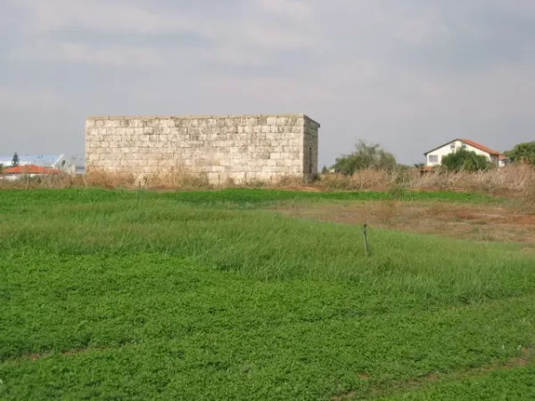
- In mid-September 1948, al-Barriyya was completely destroyed with the exception of one stone house.
- Ethnic cleansing
- al-Barriyya inhabitants were completely ethnically cleansed.
Hover a dot to read the village name, or click to open its card.
Borders of the depopulated village of al-Barriyya
Al-Barriyya – Depopulated Palestinian Village of Ramla District
Al-Barriyya was a Palestinian village in the Ramla Subdistrict, located approximately 5.5 kilometers southeast of the town of Ramla, near the eastern edge of Palestine's coastal plain. The village stood at an average elevation of about 100 meters above sea level.
It was built on a low rise overlooking broad areas to the south and west. Wadi al-Barriyya passed along the village's eastern side, while a short paved road, constructed through the voluntary labor of the villagers, connected al-Barriyya with the main Ramla–Jerusalem road.
- District
- Ramla
- Distance from Ramla
- Approximately 5.5 km southeast of Ramla
- Elevation
- Approximately 100 m above sea level
- Natural Setting
- Situated on a low rise at the eastern edge of Palestine's coastal plain, alongside Wadi al-Barriyya
- Population in 1944/1945
- 510 inhabitants
- Occupation and Depopulation Period
- The precise date is disputed; one account places the attack and depopulation between 10–13 July 1948, while the village may have been occupied earlier in May 1948 during Operation Barak
- Military Operation
- Operation Dani; with the possibility of an earlier occupation during Operation Barak
- Military Unit
- Not conclusively identified at the village level; the principal sources do not independently specify the unit that entered al-Barriyya
- Total Land Area
- 2,831 dunums
- Israeli Settlements Established on Village Lands
- Azarya, established in 1949; and Beit Hashmonay, established in 1972
Location and Village Layout
Al-Barriyya had a generally rectangular built-up area extending from east to west. As the village expanded, new construction developed mainly toward the south and southeast. Orchards and threshing floors restricted expansion toward the north, while Wadi al-Barriyya limited development on the eastern side.
In the late nineteenth century the settlement was described as a small hamlet built largely of mud brick and surrounded by cultivated land. During the British Mandate period the village grew, and the official 1931 census recorded 86 occupied houses.
Nearby localities included 'Innaba, Daniyal, al-Kunayyisa, al-Na'ani, Abu Shusha, and al-Qubab. The village's proximity and road connections also closely linked it to Ramla.
Population of Al-Barriyya
The village population increased during the British Mandate period. Official census figures should be distinguished from later estimates of the refugee population.
- 1922295Official Census of Palestine, 1922
- 1931388Official Census of Palestine, 1931
- 1944/45510Official British Mandate Village Statistics
- 19983,633 refugeesLater estimate published by Palestine Remembered; not an official census
The 1931 census also recorded 86 houses. The village population was Muslim, and al-Barriyya had a small mosque where residents worshipped.
Land Ownership in Al-Barriyya
The total land area of al-Barriyya amounted to 2,831 dunums in the 1944/45 statistics. Palestine Remembered presents a simplified ownership table using the categories Palestinian, Transferred to Zionists, and Communal/Public; these categories are retained below without replacing them with different terminology.
- Palestinian2,758 dunums97%
- Transferred to Zionists0 dunums0%
- Communal/Public73 dunums3%
The official land statistics classify the same total as 2,758 Arab-owned dunums and 73 public dunums, with no Jewish-owned land listed.
Land Use in 1944/45
- Arab
- Public
- Plantations and irrigable land51 dunums
- Cereals2,627 dunums
- Built-up area55 dunums
- Non-cultivable land98 dunums
A total of 2,678 dunums was classified as cultivated or cultivable land, representing the overwhelming majority of the village's territory.
Economic Life in Al-Barriyya
The local economy depended primarily on rain-fed agriculture and beekeeping. Cereals were the principal field crop, while watermelons, vegetables, and small orchard plots were also cultivated.
A British Royal Commission that visited the area in 1936 described al-Barriyya as one of the villages that had taken a leading role in beekeeping. Income from this activity was estimated at approximately 1,000 Palestinian pounds in 1936.
In 1944/45, 2,627 dunums were allocated to cereals and 51 dunums were irrigated or planted with orchards. Some villagers raised poultry, while a smaller number worked seasonally in nearby towns.
Water Resources
Al-Barriyya did not possess abundant permanent water sources within the village. Residents relied primarily on rainwater collected in cisterns for domestic needs and supplemented this supply with water obtained from neighboring villages.
Wadi al-Barriyya ran along the eastern edge of the village and influenced its physical growth by restricting the expansion of buildings toward the east.
Education in Al-Barriyya
An elementary school for boys was established in al-Barriyya in 1943. At the time of its establishment, the school enrolled 48 pupils and had one teacher.
The Mosque and Social Life
The village had a small mosque used by its residents. The principal historical sources reviewed for this article do not provide adequate independent documentation for any other religious building, so an isolated database field mentioning a church has not been treated as sufficiently verified evidence.
Occupation and Depopulation of Al-Barriyya
The exact chronology of al-Barriyya's occupation is uncertain, and the village's history should not be reduced to a single date without explaining the conflicting evidence.
Walid Khalidi's account, drawing on sources he discusses in All That Remains, reports that al-Barriyya was attacked and depopulated between 10 and 13 July 1948, apparently in the context of Operation Dani. Operation Dani began on 9 July and, during its first stage, aimed at capturing Lydda and Ramla and widening the Israeli-controlled corridor toward Jerusalem.
However, another military account discussed by Khalidi indicates that al-Barriyya was already in Israeli hands at the beginning of Operation Dani on 9–10 July. The operational plan designated the village as a launching point for a force assigned to encircle Lydda and Ramla.
This discrepancy led Khalidi to suggest that al-Barriyya may instead have been occupied earlier during Operation Barak in May 1948. PalQuest lists al-Barriyya among the villages affected by Operation Barak, which was led mainly by the Haganah's Giv'ati Brigade with participation by the Negev Brigade, and also among the villages affected by Operation Dani.
The village-specific sources do not independently identify the particular brigade that entered al-Barriyya. It would therefore be inaccurate to attribute the capture of the village definitively to the Giv'ati, Yiftach, Alexandroni, or any other brigade solely because those units participated in the wider military operations in the region.
Occupation Chronology
- 9–13 May 1948 and subsequent operations during May
Operation Barak
PalQuest lists al-Barriyya among the villages affected by the operation. Khalidi's account considers it possible that the village was occupied during this period, but does not present this as certain.
- 9–10 July 1948
Beginning of Operation Dani
The operational plan designated al-Barriyya as a launching point for a force assigned to encircle Lydda and Ramla, indicating that the village was already under Israeli control at or immediately before the beginning of the operation.
- 10–13 July 1948
Attack and depopulation according to another account
Sources discussed by Khalidi state that al-Barriyya was attacked and depopulated during this period, apparently in the context of Operation Dani.
- September 1948
Confirmed Israeli control
By September the village was firmly under Israeli control. A request to authorize its destruction was reportedly made by David Ben-Gurion in mid-September, although the cited account does not establish whether that request itself was formally implemented.
- September 1948
Temporary settlement attempt
Jewish immigrants were temporarily placed at a site referred to as “Barriyya Bet,” but reportedly left it by 21 September 1948.
- After occupation; precise date uncertain
Destruction of the village
Most of the village was subsequently leveled, although one stone house and fragments of other structures remained according to Khalidi's field description.
Military Operation and Unit
Military operation: The depopulation of al-Barriyya is most commonly associated with Operation Dani in July 1948, although the historical record leaves open the possibility that the village had already been occupied during Operation Barak in May.
Military unit: The core village sources do not identify a single unit as the independently verified force that captured al-Barriyya. Operation Barak was led principally by the Giv'ati Brigade, with the Negev Brigade also participating. Operation Dani was carried out by a composite force that included the Har'el, Yiftach, and Eighth Armored brigades, as well as an infantry battalion from Kiryati and the Third Infantry Battalion of the Alexandroni Brigade. Participation in the broader operation should not be treated as proof that any one of these units captured al-Barriyya itself.
Cause of Depopulation
The depopulation of al-Barriyya was connected to the military operations around Lydda and Ramla. Palestine Remembered classifies the cause as a military assault, while the historical narrative reports an attack and the displacement of the villagers during the 1948 fighting. The Palestinian population of al-Barriyya was entirely displaced in the course of the Nakba and the occupation of Palestine in 1948.
Destruction of Al-Barriyya
Most of the village's built-up area was eventually destroyed. A historical account reports that in mid-September 1948 David Ben-Gurion requested authorization to destroy al-Barriyya, although the source does not establish whether the request was implemented immediately or precisely when the subsequent demolition took place.
Walid Khalidi's later field description records that the site had been largely cleared and leveled, apart from one surviving stone house and fragments of the walls of two concrete houses.
Israeli Settlements on Al-Barriyya Village Lands
Azarya was established in 1949 on al-Barriyya's lands, while Beit Hashmonay was established there in 1972.
Kfar Shmuel, established in 1950 and located east of the village site, was built on the lands of the depopulated village of 'Innaba rather than on al-Barriyya's lands and should therefore not be listed as a settlement established on al-Barriyya territory.
Al-Barriyya Today
According to the field description documented by Walid Khalidi before the publication of All That Remains in 1992, the village site had been largely cleared and leveled. One stone house remained standing, together with sections of concrete walls from two other houses, with steel reinforcement bars protruding from them.
This description reflects historical field documentation and should not be presented as a direct field verification of conditions in 2026. Palestine Remembered also hosts later community documentation labeled as dating from 2020 and referring to a surviving house at the site; such material is useful as later community documentation but does not constitute an independent and comprehensive contemporary survey of the entire village site.
Sources
- PalQuest – Interactive Encyclopedia of the Palestine Question: al-Barriyya.
- PalQuest – Operation Dani.
- PalQuest – Operation Barak.
- Palestine Remembered – al-Barriyya, Ramla District.
- Walid Khalidi, All That Remains: The Palestinian Villages Occupied and Depopulated by Israel in 1948.
- Government of Palestine, Census of Palestine, 1922.
- E. Mills, Census of Palestine 1931: Population of Villages, Towns and Administrative Areas.
- Government of Palestine, Village Statistics, 1945, reproduced by Sami Hadawi.
Photo gallery


Photos from the village's people
Photos sent in by visitors and published after review.
Add a photo of this village
Log in to add photos of this village.
Other villages from Ramla
More from the archive



 Download Our Palestine App
The whole archive in the palm of your hand: depopulated villages, the Nakba, the massacres and Al-Aqsa — free, with no ads to erase the story.
Download Our Palestine App
The whole archive in the palm of your hand: depopulated villages, the Nakba, the massacres and Al-Aqsa — free, with no ads to erase the story.



Comments
No comments yet — be the first to write one.
Add your comment
Name and email are optional. Comments appear after review.