
The depopulated village of Shahma / District of Ramla
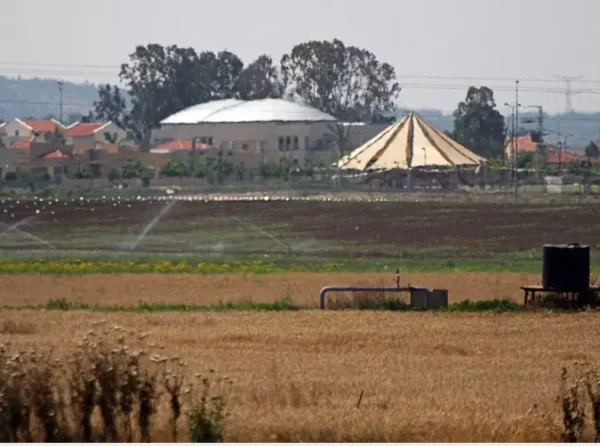
About the depopulated village of Shahma
- District
- Ramla
- Date Shahma was occupied
- 14 May 1948
- Population in 1948
- 330
- Military operation
- Operation Barak
- Brigade that carried it out
- Givati Brigade
- Distance from the governorate centre
- 15 (km) Southwest of al-Ramla
- Elevation above sea level
- 50 m
- Cause of displacement
- Influence of fall of, or exoduce from, neighboring town
- Extent of destruction
- Shahama was most likely destroyed. Currently, it's being used by the Israeli Air Force.
- Ethnic cleansing
- Shahma inhabitants were completely ethnically cleansed.
Hover a dot to read the village name, or click to open its card.
Borders of the depopulated village of Shahma
Shahma – Depopulated Palestinian Village of the Ramla Subdistrict
Shahma was a Palestinian village in the Ramla Subdistrict, situated on the coastal plain approximately 15 kilometers southwest of Ramla. It stood on relatively flat ground slightly higher than the terrain to its south and southeast.
The village had an average elevation of approximately 50 meters above sea level. Wadi al-Sarar passed about one kilometer southwest of the village, while a secondary road linked Shahma with the main roads leading to Ramla and the coastal highway. During the Second World War, the British constructed 'Aqir military airfield immediately north of the village and the Shahma military camp to the north and east.
- Subdistrict
- Ramla
- Mandate District
- Lydda
- Distance from Ramla
- Approximately 15 km southwest
- Average Elevation
- Approximately 50 meters
- Population in 1922
- 107 – official Mandate census figure; some later Palestinian secondary sources give different totals
- Population in 1931
- 150, all Muslims
- Occupied Houses in 1931
- 34
- Population in 1944/1945
- 280
- Estimated Population in 1948
- Approximately 325 – later estimate, not an official census
- Total Land Area in 1945
- 6,875 dunums
- Depopulation Date
- 14 May 1948
- Military Operation
- Operation Barak
- Military Unit
- Giv'ati Brigade
- Cause of Depopulation
- Military pressure and the effect of the fall or evacuation of neighboring Palestinian localities during the Giv'ati advance
- Extent of Destruction
- The Palestinian village ceased to exist as a built-up community; no reliable numerical destruction percentage is documented
- Confirmed Israeli Settlements on Village Land
- None according to Walid Khalidi and PalQuest; the village site was incorporated into a fenced military airfield
Name
Mustafa Murad al-Dabbagh suggested that the name Shahma may derive from an Aramaic/Syriac form similar to “Shahima,” associated with meanings such as dark, dusty, simple, or ordinary.
This interpretation is presented as an attributed linguistic hypothesis rather than a conclusively documented etymology.
Location
Shahma stood on the central coastal plain on relatively level ground that rose slightly above the land immediately to the south and southeast.
Wadi al-Sarar passed south and southwest of the village at a distance of approximately one kilometer, while the Wadi al-Sarar railway station lay farther to the southeast.
A secondary road connected the village with routes to Ramla and the main coastal highway.
'Aqir Airfield and Shahma Military Camp
The local landscape changed considerably during the Second World War when the British Mandate authorities constructed a military airfield known as 'Aqir immediately north of Shahma.
A separate military camp was established to the east and northeast of the village.
These military installations became a major feature of Shahma's immediate surroundings before the Nakba. After 1948, the former Palestinian village site itself was incorporated into a fenced military airfield.
Shahma in the Nineteenth Century
Nineteenth-century travelers and surveyors described Shahma as a small village.
The Survey of Western Palestine characterized it as a small adobe-built village whose inhabitants obtained water from a well south of the settlement.
Earlier visitors also reported ancient remains and pools at the site, helping explain why stones from older structures were later reused in some village houses.
Built Environment
The Mandate-era Palestine Index Gazetteer classified Shahma as a hamlet or small agricultural locality.
The village was divided into northern and southern sections by the secondary road passing through it.
Most houses were built of adobe, while some incorporated stone from earlier structures on the site.
The built-up area in 1945 covered approximately 11 dunums.
Population in 1922 and the Source Discrepancy
Later Palestinian sources do not agree on Shahma's 1922 population, with figures of 80 and 87 appearing in different compilations.
The source citing J. B. Barron's official Census of Palestine, 1922, however, gives 107 inhabitants, all Muslims.
This article therefore uses 107 as the figure closest to the official census while explicitly noting the discrepancy in secondary literature.
Population in 1931
- 193115034
All of Shahma's inhabitants recorded in 1931 were Muslims.
Population in 1944/1945
The official 1944/45 statistics recorded 280 Arab Palestinian inhabitants in Shahma.
This reflects substantial population growth during the Mandate period.
Estimated Population in 1948
Later Palestinian registers give approximately 325 inhabitants for Shahma in 1948, while some databases round the figure to around 330.
The 325 figure is a retrospective estimate and should not be described as an official census conducted in 1948.
- 1922107Official Mandate census; some secondary Palestinian sources give different figures
- 1931150Official Census of Palestine
- 1944/1945280Official statistics
- 1948325Later demographic estimate
Land Ownership in 1945
Shahma's registered land area totaled 6,875 dunums.
- Palestinian5,165 dunums75%
- Transferred to Zionists220 dunums3%
- Communal/Public1,490 dunums22%
The official Mandate table uses the categories Arab, Jewish, and Public: 5,165 Arab dunums, 220 Jewish dunums, and 1,490 public dunums.
Land Use in 1945
- Palestinian
- Transferred to Zionists
- Communal/Public
- Citrus and Bananas152 dunums
- Plantations and Irrigable Land33 dunums
- Cereals6,420 dunums
- Built-up11 dunums
- Non-Cultivable259 dunums
Approximately 96 percent of Shahma's land was classified as cultivable or cultivated in the 1945 statistics.
Correction to the Cereal-Land Figure
Some later Palestinian databases list 6,200 dunums as Palestinian cereal land.
The official table instead separates cereal land into:
- 4,911 Arab/Palestinian dunums.
- 220 Jewish dunums.
- 1,289 public dunums.
The correct total cereal area is therefore 6,420 dunums.
Olive Cultivation
The Palestinian Encyclopedia reports approximately 40 dunums of olive cultivation in 1943.
The official 1945 land-use table does not provide olive land as an additional independent category. The 40 dunums are therefore not added on top of the 6,605 dunums of cultivable land, avoiding double counting.
Economic Life
Agriculture formed the basis of Shahma's economy, especially cereal cultivation.
Citrus, orchards, irrigated plots, and livestock raising also contributed to village livelihoods.
Oral accounts from villagers additionally recall crops such as lentils, sesame, vegetables, fodder crops, wheat, and barley.
Water
Shahma had no major natural springs and depended on wells for drinking water and household use.
Nineteenth-century descriptions specifically mention a well south of the village from which residents obtained water.
Education and Services
The principal sources reviewed do not document an independent school or health facility inside Shahma.
No educational or medical institution is therefore attributed to the village without direct evidence.
Village Families
Local oral-history and community records name several Shahma families, including Hasan, al-Qrinawi, 'Awad, Khadr, Katkat, al-Mudhakkir, Shahin, Abu Haniyya, al-Mahshi, al-Hattawi, al-Yakhri, and al-Ra'i.
This is community documentation rather than an official population register.
Occupation and Depopulation
Several Palestinian sources give 14 May 1948 as Shahma's depopulation date.
The village lay within the zone of the Giv'ati Brigade's advance during Operation Barak, which targeted Palestinian localities south and west of Ramla and across the southern coastal plain.
Palestine Remembered associates Shahma with the Giv'ati Brigade and Operation Barak.
Its depopulation cause is classified as the influence of the fall or evacuation of a neighboring Palestinian locality, meaning that the available sources do not necessarily establish a separate detailed battle inside Shahma itself.
Operation Barak
Operation Barak was launched by the Haganah's Giv'ati Brigade in May 1948 to expand control over the coastal region south and west of Ramla before the end of the British Mandate.
PalQuest dates its principal first stage to 9–13 May and describes a subsequent continuation of the offensive as British forces withdrew.
Because Shahma's recorded depopulation date is 14 May, it falls within the immediate continuation of the Barak campaign. This explains why some village compilations describe Shahma as part of the “first stage” even though the formal operation chronology places 14 May immediately after its initial phase.
Military Unit
The military unit associated with Shahma's depopulation was the Giv'ati Brigade.
Giv'ati was the principal force operating on the Ramla and coastal-plain axis during Operation Barak, while the Negev Brigade participated elsewhere in the wider campaign.
Occupation and Displacement Chronology
- Until spring 1948
Pre-Nakba Village
A small agricultural village with 280 inhabitants in 1944/45 and extensive cereal and citrus cultivation.
- 9 May 1948
Beginning of Operation Barak
The Giv'ati Brigade began a major offensive against Palestinian localities in the southern and western Ramla region and coastal plain.
- 13 May 1948
End of the Formal First Phase
Military pressure continued as the British Mandate approached its final day.
- 14 May 1948
Depopulation of Shahma
Several Palestinian sources record the inhabitants' departure on this date in the context of the Giv'ati advance and Operation Barak.
- Mid–late May 1948
Continuation of the Barak Campaign
Further Palestinian villages in the southern coastal plain were occupied and depopulated.
Cause of Displacement
The principal sources do not provide a detailed account of a separate major assault fought inside Shahma itself.
The village's depopulation is classified as resulting from the influence of the fall or evacuation of a nearby Palestinian locality.
At the same time, Shahma lay directly within the zone of Giv'ati military operations during Operation Barak.
The most accurate formulation is therefore: the inhabitants left under the pressure of military operations, the Giv'ati advance, and the fall or evacuation of neighboring Palestinian communities during Operation Barak.
Extent of Destruction
Shahma ceased to exist as a Palestinian built-up village after the Nakba.
Palestinian sources describe the village as destroyed, but no reliable numerical percentage of destruction is documented.
The location was subsequently incorporated into a fenced military area, limiting direct access to the former village site.
Israeli Settlements on Shahma Land
According to Walid Khalidi and PalQuest, no Israeli settlement was established on Shahma's village lands.
An older Palestinian Encyclopedia entry gives a different account, stating that Kidron, founded in 1949, was located on land associated with both Shahma and Qatra.
More specific documentation for Qatra, however, identifies Kidron as established on Qatra land.
This article therefore does not list Kidron as a confirmed settlement on Shahma land and preserves the source disagreement rather than resolving it without cadastral evidence.
Shahma Today
Walid Khalidi's historical field description records that Shahma's site was incorporated into a fenced military airfield.
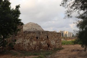
Cactuses, thorny vegetation, and bushes were visible from outside the fenced area, while the Palestinian village itself no longer survived as an independent built-up locality.
This description comes from historical field research incorporated into All That Remains and should not be treated as direct field verification of conditions in 2026.
Sources
- PalQuest – Interactive Encyclopedia of the Palestine Question: Shahma
- PalQuest – Operation Barak
- Institute for Palestine Studies – Walid Khalidi, All That Remains
- Government of Palestine – Census of Palestine, 1922
- Government of Palestine – Census of Palestine, 1931
- Village Statistics 1945 – Shahma: Population and Land Ownership
- Village Statistics 1945 – Shahma: Cultivable Land
- Village Statistics 1945 – Shahma: Built-up and Non-Cultivable Land
- Palestine Remembered – Shahma, al-Ramla
- Palestinian Encyclopedia – Shahma
- WAFA – Palestinian Localities Depopulated in 1948
Photo gallery

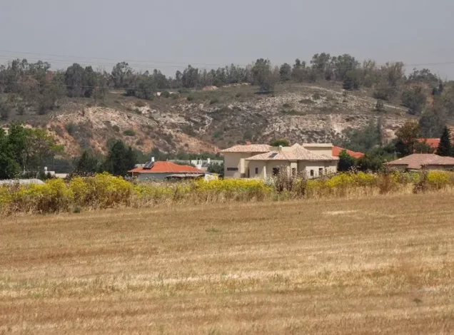

Photos from the village's people
Photos sent in by visitors and published after review.
Add a photo of this village
Log in to add photos of this village.
Other villages from Ramla

More from the archive



 Download Our Palestine App
The whole archive in the palm of your hand: depopulated villages, the Nakba, the massacres and Al-Aqsa — free, with no ads to erase the story.
Download Our Palestine App
The whole archive in the palm of your hand: depopulated villages, the Nakba, the massacres and Al-Aqsa — free, with no ads to erase the story.



Comments
No comments yet — be the first to write one.
Add your comment
Name and email are optional. Comments appear after review.