
The depopulated village of Al-Haditha / District of Ramla
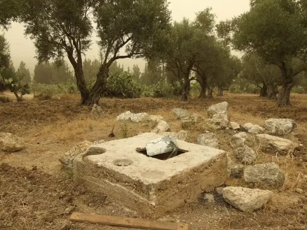
Al-Haditha
About the depopulated village of Al-Haditha
- District
- Ramla
- Date Al-Haditha was occupied
- 12 July 1948
- Military operation
- Operation Dani
- Distance from the governorate centre
- 8 (km) Northeast of al-Ramla
- Elevation above sea level
- 125 m
- Cause of displacement
- Military assault by Zionist troops
- Extent of destruction
- On September 14th, 1948, al-Haditha was mostly destroyed with the exception of one house remain standing.
- Ethnic cleansing
- al-Haditha inhabitants were completely ethnically cleansed.
Hover a dot to read the village name, or click to open its card.
Borders of the depopulated village of Al-Haditha
Al-Haditha – Depopulated Palestinian Village in Ramla Subdistrict
Al-Haditha was a Palestinian village in the Ramla subdistrict of the Lydda district. It stood in hilly terrain at the eastern edge of the central coastal plain, on the western side of Wadi al-Natuf, approximately 8 kilometers northeast of Ramla, at an average elevation of about 125 meters above sea level.
The village had 760 inhabitants in the official 1944/45 statistics, all Muslims, and a registered land area of 7,110 dunums. Agriculture formed the basis of village life, particularly cereal and olive cultivation and other orchards.
Israeli forces occupied Al-Haditha on 12 July 1948 during the first stage of Operation Dani, while the assault on Lydda and Ramla was under way. Approximately two months later, on 14 September, the village was officially proposed for partial demolition, and most of its built-up area was subsequently destroyed.
Key Facts about Al-Haditha
| Field | Information |
|---|---|
| Name | Al-Haditha |
| Subdistrict | Ramla |
| Status | Depopulated Palestinian village |
| Distance from Ramla | Approximately 8 km northeast |
| Average elevation | Approximately 125 m above sea level |
| Population, 1944/45 | 760 |
| Houses, 1931 | 119 |
| Registered land area | 7,110 dunums |
| Occupation date | 12 July 1948 |
| Military operation | First stage of Operation Dani |
| Village-specific attacking unit | Not independently identified; several brigades and battalions participated in the first stage of Operation Dani |
| Cause of depopulation | Palestine Remembered classifies it as direct military assault; Khalidi does not provide a separate village-specific expulsion order |
| Demolition decision | 14 September 1948 – village proposed for partial demolition |
| Extent of destruction | Most village buildings were destroyed; one house remained in Khalidi's field description |
| Settlement on village land | Hadid – 1950 |
Location of Al-Haditha
Al-Haditha stood in hilly terrain on the eastern edge of the central coastal plain, along the western side of Wadi al-Natuf.
The village lay approximately one kilometer east of the main road linking Lydda with Bayt Nabala and villages farther north. Secondary roads connected Al-Haditha with that highway and with neighboring communities.
Neighboring lands included those of Bayt Nabala, Budrus, Jindas, Dayr Abu Salama, Khirbat Zakariyya, and Khirbat al-Qubayba.
The Name and Historical Site
The Arabic name Al-Haditha literally carries the sense of “the new,” although the settlement site itself was far older than the later Arabic name.
Historians and archaeologists have identified or associated the location with ancient Hadid mentioned in historical and religious sources. The locality was also connected with the name Adida in the Hellenistic period, while the Byzantine historian Eusebius referred to a similarly named place east of Lydda.
These identifications should be understood as historical and archaeological interpretations of the site rather than assuming that every tradition associated with the ancient locality is equally established.
Al-Haditha in the Nineteenth Century
The French traveler Victor Guérin visited the area in the nineteenth century and described Al-Haditha as standing on the top of a hill with a relatively small number of houses.
Nineteenth-century descriptions also recorded ancient cisterns, tombs, caves, architectural remains, and other traces of earlier settlement in and around the village site.
Village Layout and Buildings
Al-Haditha originally had a roughly trapezoidal layout. As construction expanded during the late Mandate period, the built-up area became more rectangular.
Houses clustered around the village center, which contained a mosque, a small marketplace, and an elementary school.
The official 1944/45 statistics recorded 16 dunums as built-up land.
Population of Al-Haditha
- 1922415Official British Mandate census; all Muslims
- 1931520Official census; all Muslims
- 1944/45760Official Village Statistics; all Arabs and Muslims
- 1948882Later estimate reported by Palestine Remembered, not an official census
- 19985,414 refugeesLater estimate of refugees and descendants reported by Palestine Remembered
The 1948 and 1998 figures are later estimates and should not be attributed to British Mandatory Village Statistics despite the generic source label displayed beneath the Palestine Remembered table.
Number of Houses
- 1931119Official Census of Palestine figure
- 1948201Later Palestine Remembered estimate, not an official census count
Land Ownership in Al-Haditha
The registered land area of Al-Haditha in 1944/45 totaled 7,110 dunums.
- Palestinian6,544 dunums92%
- Transferred to Zionists157 dunums2%
- Communal/Public409 dunums6%
The figures balance correctly: 6,544 + 157 + 409 = 7,110 dunums.
The original official categories were 6,544 Arab dunums, 157 Jewish dunums, and 409 Public dunums.
Land Use in 1944/45
- Arab
- Jewish
- Public
- Cereals4,523 dunums
- Plantations and irrigable land246 dunums
- Citrus and bananas10 dunums
- Built-up land16 dunums
- Non-cultivable land2,315 dunums
The table balances exactly: 4,523 + 246 + 10 + 16 + 2,315 = 7,110 dunums.
Palestine Remembered displays 4,421 dunums of cereals under the Palestinian column, apparently combining 4,419 Arab dunums with 2 Public dunums. It likewise displays 2,260 dunums of non-arable land under the Palestinian column by combining 1,853 Arab and 407 Public dunums. The official Public category has therefore been kept separate here.
Approximately 200 dunums of olive groves were included within the 246 dunums classified as plantations and irrigable land. Olive acreage is therefore a subcategory and should not be added again to the total.
Economic Life
Agriculture formed the principal source of livelihood. Cereals and olives were among the village's most important crops.
In 1944/45, cereals occupied a total of 4,523 dunums, while 246 dunums were irrigated or used for plantations. Approximately 200 dunums within the latter category were devoted to olives.
A further 10 dunums were used for citrus and bananas.
The small village marketplace provided local commercial services connected with everyday life and agricultural production.
Water Resources
Archaeological remains around the village site include cisterns and other ancient water installations, while later community documentation also records the remains of wells at Al-Haditha.
Khalidi's village entry does not provide a complete independent list of named Mandate-era village wells or springs, so no specific water-source names have been added without additional documentation.
Education
An elementary school was established in Al-Haditha in 1924.
Walid Khalidi and PalQuest record an enrollment of 42 pupils in 1943.
Palestine Remembered's automated table instead attaches the same enrollment figure to 1945, while the detailed Khalidi narrative reproduced on the site specifies 1943. The date in the principal narrative is therefore retained here.
Mosque and Local Institutions
A mosque stood in the center of Al-Haditha alongside the school and the small marketplace.
Khalidi's village entry does not independently document another religious institution in the village, so no church or separate shrine has been added without stronger evidence.
Archaeological Remains
Al-Haditha occupied a site with substantial archaeological remains and has been historically associated with ancient Hadid.
Documented remains in and around the site included a mound, building foundations, column fragments, mosaic flooring, cisterns, tombs, and rock-cut caves.
These features demonstrate long-term settlement at the site, although assigning each remain to a specific period requires specialist archaeological evidence.
Operation Dani
Operation Dani began on 9 July 1948 and continued until 18 July. It was one of the largest Israeli offensives launched during the “Ten Days” between the two truces.
The operation was divided into two stages. The first, from 9 to 12 July, targeted Lydda, Ramla, and surrounding villages. The second, from 13 to 18 July, extended eastward toward the Jerusalem corridor and the Ramallah–Latrun road.
The first stage was carried out by a composite force including the Har'el and Yiftach brigades, the Eighth Armored Brigade, a Kiryati infantry battalion, and the Third Infantry Battalion of the Alexandroni Brigade.
Yiftach units approached Lydda and Ramla from the south, while forces from the other formations advanced from the north and seized villages along their routes.
Occupation and Depopulation of Al-Haditha
Al-Haditha was occupied on 12 July 1948 while the assault on Lydda and Ramla was under way, on the final day of the first stage of Operation Dani.
Khalidi and PalQuest clearly establish the date and operation but do not identify the specific brigade or battalion that entered Al-Haditha itself.
Because several formations participated in the first stage, no single brigade should be assigned as the village-specific attacking unit merely from its participation in Operation Dani.
Palestine Remembered classifies the villagers' departure as the result of direct military assault and describes the village as completely depopulated.
Khalidi's Al-Haditha entry does not separately document a village-specific expulsion order or the precise route taken by the residents. The occupation and depopulation are therefore placed firmly within the military assault, while the more specific classification of the departure mechanism remains attributed to the source that provides it.
Destruction of Al-Haditha
Al-Haditha was not completely demolished on the day it was occupied.
Approximately two months later, on 14 September 1948, Israeli prime minister David Ben-Gurion placed Al-Haditha among villages proposed for partial destruction, citing insufficient manpower to hold the area “in depth.”
Under procedures introduced at the time, approval was sought from the special ministerial committee charged with overseeing village demolitions.
By the period of Khalidi's later fieldwork, only one village house remained standing amid extensive rubble. This indicates that demolition ultimately became much more extensive, although the principal source does not provide a precise date for every phase of destruction.
Occupation Chronology
- 9 July 1948
Beginning of Operation Dani
The offensive began against the Lydda-Ramla area and the Jerusalem corridor.
- 9–12 July 1948
First stage of Operation Dani
The first stage targeted Lydda, Ramla, and surrounding villages.
- 12 July 1948
Occupation of Al-Haditha
The village was occupied during the attack on Lydda and Ramla; the specific unit entering the village is not identified in the village entry.
- In the context of the 12 July occupation
Depopulation
Palestine Remembered classifies the cause as direct military assault; Khalidi does not provide a separate village-specific expulsion order.
- 14 September 1948
Partial-demolition decision
Ben-Gurion requested ministerial approval for partial demolition of Al-Haditha.
- Precise chronology not documented
Later destruction
Most village structures were eventually destroyed, leaving only one house standing in Khalidi's field description.
Israeli Settlement on Al-Haditha's Lands
| Settlement | Established | Relationship to Al-Haditha |
|---|---|---|
| Hadid | 1950 | Established on village land approximately 2 km northwest of the ruins of Al-Haditha |
Al-Haditha Today
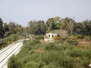
According to Walid Khalidi's field description, stone and concrete rubble from destroyed village houses remained visible across the site.
Only one house was still standing. It was sealed and abandoned and had a gabled tiled roof.
Clusters of Christ-thorn, olive, and eucalyptus trees remained at the site. The old village road also survived but had been widened, while the surrounding land was under cultivation.
Khalidi's description is based on fieldwork undertaken before the publication of All That Remains in 1992 and should therefore be treated as a documented historical site description rather than direct comprehensive field verification of conditions in 2026.
Palestine Remembered contains later community documentation of wells, the cemetery, rubble, olive trees, and other remains. The Palestinian heritage association Dayratna also organized a documented field visit to Al-Haditha in May 2009. Such material helps trace later conditions at particular landmarks but does not constitute a comprehensive independent survey of all village lands today.
Sources
- PalQuest – Interactive Encyclopedia of the Palestine Question: Al-Haditha
- PalQuest – Operation Dani
- Palestine Remembered – Al-Haditha, Ramla District
- Walid Khalidi – All That Remains: Al-Haditha
- Government of Palestine – Census of Palestine 1922, Palestinian Central Bureau of Statistics reproduction
- Government of Palestine – Census of Palestine 1931
- Institute for Palestine Studies – All That Remains, Walid Khalidi
Photo gallery


Photos from the village's people
Photos sent in by visitors and published after review.
Add a photo of this village
Log in to add photos of this village.
Other villages from Ramla
More from the archive



 Download Our Palestine App
The whole archive in the palm of your hand: depopulated villages, the Nakba, the massacres and Al-Aqsa — free, with no ads to erase the story.
Download Our Palestine App
The whole archive in the palm of your hand: depopulated villages, the Nakba, the massacres and Al-Aqsa — free, with no ads to erase the story.



Comments
No comments yet — be the first to write one.
Add your comment
Name and email are optional. Comments appear after review.