
The depopulated village of Aqir / District of Ramla

About the depopulated village of Aqir
- District
- Ramla
- Date Aqir was occupied
- 06 May 1948
- Population in 1948
- 2,877
- Brigade that carried it out
- Givati Brigade
- Distance from the governorate centre
- 9 (km) Southwest of al-Ramla
- Elevation above sea level
- 50 m
- Cause of displacement
- Military assault by Zionist troops
- Extent of destruction
- 'Aqior was mostly destroyed with the exception of five of its houses.
- Ethnic cleansing
- 'Aqir inhabitants were completely ethnically cleansed.
Hover a dot to read the village name, or click to open its card.
Borders of the depopulated village of Aqir
Aqir – Depopulated Palestinian Village of Ramla
Aqir was a Palestinian village in the Ramla Subdistrict, located on the central coastal plain approximately 9 kilometers southwest of al-Ramla and about 50 meters above sea level. Wadi al-Nasufiyya ran approximately one kilometer south of the village, while a secondary road connected it with the main road leading to al-Ramla and other regional centers.
Aqir was a relatively large village. Its population was officially estimated at 2,480 in 1944/45, and its lands covered 15,825 dunums. Fertile soil, abundant groundwater, citrus groves, two elementary schools, two mosques, and two shrines were among the principal features of the village before the Nakba.
The direct military action against Aqir began on 5 May 1948, when the Haganah's Giv'ati Brigade surrounded the village while implementing its assigned part of Plan Dalet. The force temporarily withdrew after British intervention but returned the following day and occupied Aqir after most of its inhabitants had fled. Approximately thirty villagers remained for a short period before being expelled during the following weeks.
Basic Information
| Field | Information |
|---|---|
| Name | Aqir / 'Aqir |
| Arabic name | عاقر |
| Alternative name | 'Aqur in some sources |
| Subdistrict | Ramla |
| Administrative district | Lydda |
| Region | Central coastal plain |
| Distance from al-Ramla | Approximately 9 km southwest |
| Elevation | Approximately 50 m above sea level |
| Total land area | 15,825 dunums |
| Population in 1944/45 | 2,480 – official Mandate-period estimate |
| Houses in 1931 | 401 |
| Initial encirclement | 5 May 1948 according to the current PalQuest entry |
| Final occupation | 6 May 1948 according to current PalQuest and Palestine Remembered; an older reproduction gives a 4–5 May sequence |
| Military context | Giv'ati Brigade implementation of Plan Dalet; Aqir was occupied before Operation Barak began on 9 May |
| Military unit | Giv'ati Brigade; no specific village-level battalion is independently documented |
| Cause of depopulation | Military encirclement and pressure followed by occupation, with the remaining inhabitants expelled in the following weeks |
| Destruction | Most of the village was destroyed, but several houses survived |
Name and Earlier History
Palestinian sources also record the form 'Aqur for the village name. Aqir was identified in historical geographical literature with the Roman-period town of Accaron.
In the tenth century, the Palestinian geographer al-Muqaddasi described Aqir as a large village with a large mosque. He noted a distinctive type of bread produced by its inhabitants and described the villagers as generous and hospitable.
In 1596 Aqir formed part of the nahiya of Ramla in the liwa' of Gaza. Its population has been estimated at approximately 161 from the Ottoman fiscal register. Taxes were levied on wheat, barley, fruit, vineyards, goats, beehives, and other forms of production.
Aqir in the Nineteenth Century
Edward Robinson visited Aqir in 1838 and described a sizable village surrounded by cultivated gardens and fertile fields.
By the late nineteenth century, much of the village was built of sun-dried adobe on relatively low terrain. The Survey of Western Palestine described an adobe settlement surrounded by cactus-enclosed gardens and recorded a well to the north.
Location and Geography
Aqir stood on the central coastal plain approximately one kilometer north of Wadi al-Nasufiyya. The fertile plain and abundant groundwater provided favorable conditions for intensive agriculture.
A secondary road linked the village with the main road to al-Ramla. Nearby Palestinian localities included Zarnuqa, al-Maghar, Shahma, al-Mansura, al-Na'ani, and Tall al-Battikh.
Built Environment
Aqir had an approximately rectangular layout, and its houses stood close together. Building materials included mud, adobe, cement, and stone.
During the later Mandate period, construction expanded particularly north of the secondary road that divided the built-up area.
During the Second World War, British authorities established a military airfield south of Aqir and a military hospital approximately two kilometers north of the village.
Population
- 1596Approx. 161Estimate derived from an Ottoman fiscal register, not a modern census
- 19221,155Official Government of Palestine census
- 19311,691Official census; 1,689 Muslims and two Christians
- 1944/452,480Official Government of Palestine estimate, not a new census
- 19482,877Later Palestine Remembered estimate, not an official census
- 199817,667Later estimate of refugees and descendants, not an official census
Number of Houses
- 1931401Official 1931 census figure
- 1948682Later Palestine Remembered estimate, not an official Mandate figure
Land Ownership, 1944/45
- Palestinian11,322 dunums72%
- Transferred to Zionists3,222 dunums20%
- Public1,281 dunums8%
The original Government of Palestine table used the categories Arab, Jewish, and Public. The figures total exactly 15,825 dunums.
Land Use, 1944/45
- Palestinian
- Transferred to Zionists
- Public
- Citrus and bananas2,695 dunums
- Plantations and irrigable land950 dunums
- Cereals11,516 dunums
- Built-up area46 dunums
- Non-cultivable land618 dunums
The table balances exactly: 2,695 + 950 + 11,516 + 46 + 618 = 15,825 dunums.
This corrects an error in a Palestine Remembered summary table that assigns 9,739 dunums of cereal land to the Palestinian column. The official table records 8,968 Palestinian dunums and 771 public dunums; the secondary figure appears to combine those two categories.
Economy and Agriculture
Agriculture formed the basis of Aqir's economy. Fertile soil and plentiful groundwater allowed substantial orchard cultivation.
Several artesian wells were drilled on village lands during the 1940s and were used particularly to irrigate citrus orchards. Villagers also cultivated grapes, figs, and apricots, while cereals depended more heavily on rainfall.
In 1944/45, citrus and bananas occupied 2,695 dunums across all ownership categories, plantations and irrigable land totaled 950 dunums, and cereal cultivation extended over 11,516 dunums.
Water
Aqir had abundant groundwater, and artesian wells drilled during the 1940s supplied irrigation water to the orchards.
Wadi al-Nasufiyya ran approximately one kilometer south of the village.
Education
Aqir had two elementary schools. The boys' school was founded in 1921, and a separate girls' school also operated in the village.
According to Walid Khalidi, enrollment in 1947 totaled 391 boys and 46 girls.
Palestine Remembered gives 1945 as the founding year of the girls' school, but Khalidi's principal account does not state a founding year. This article therefore does not treat 1945 as conclusively established.
Mosques and Shrines
Khalidi documents two mosques and two shrines in Aqir.
A later Palestinian community contribution to Palestine Remembered names the shrines as those of al-Nabi Aqir and 'Ubada ibn al-Samit. Because these names derive from family oral testimony rather than the principal historical account, they are retained as community documentation rather than independently confirmed identifications.
An automated Palestine Remembered field also mentions a church. The principal source used here does not document such a building, and the presence of two Christians in the 1931 census does not by itself establish that Aqir had a church.
Plan Dalet and the Military Context
Aqir was the first village taken by the Giv'ati Brigade when the brigade began implementing its assigned portion of Plan Dalet in the central coastal plain.
This action should be distinguished from Operation Barak. PalQuest dates Operation Barak from 9 May 1948, after Aqir had already been occupied.
The occupation of Aqir is therefore classified here as part of Giv'ati's implementation of Plan Dalet rather than as an occupation carried out during Operation Barak, although the action immediately preceded Giv'ati's broader May offensive in the region.
The Attack on Aqir
According to the current PalQuest entry, the Giv'ati Brigade moved south from Rehovot on 5 May 1948 and surrounded Aqir.
The Haganah force demanded that the villagers hand over their weapons. After weapons were surrendered, intelligence officers reportedly believed that further arms were being withheld, and eight villagers were taken hostage with a promise that they would be released when additional weapons were handed over.
British forces intervened and the Giv'ati force temporarily withdrew. Khalidi's account cites a contemporary press report stating that the confrontation lasted approximately six and a half hours and that about 3,000 people left during the crisis, although this figure probably included refugees from neighboring villages who had been staying in Aqir.
Final Occupation – 6 May 1948
The following day Giv'ati units returned and occupied Aqir. Most of the village's residents had already sought refuge in nearby Yibna and al-Maghar.
The current PalQuest entry and Palestine Remembered's principal village record therefore support 6 May 1948 as the final occupation date.
An older reproduction of Khalidi's text on Palestine Remembered, repeated by a Palestinian village encyclopedia, instead places the encirclement on 4 May and the occupation on the following day. This article preserves the discrepancy but follows the current PalQuest chronology of 5 May for the encirclement and 6 May for the occupation.
Expulsion of the Remaining Villagers
The occupation on 6 May did not immediately leave Aqir completely empty. Approximately thirty villagers remained behind.
Khalidi reports that these remaining inhabitants were expelled within the following few weeks. The military occupation date and the completion of the village's depopulation must therefore be treated as separate stages.
Military Unit
The Giv'ati Brigade of the Haganah is independently documented as the formation that surrounded and occupied Aqir.
Khalidi and PalQuest do not identify a specific battalion as the village-level attacking unit. No battalion number is therefore assigned without additional documentation.
Cause of Depopulation
Palestine Remembered classifies the cause as direct military assault.
The fuller chronology shows a sequence of military encirclement, an ultimatum to surrender weapons, hostage-taking, flight under pressure, occupation the following day, and the subsequent expulsion of those who remained.
Aqir's depopulation is therefore best described as resulting from military pressure and attack followed by occupation and the later expulsion of the remaining residents.
Destruction
Most of Aqir's built-up area was subsequently destroyed, but the village was not completely erased.
The principal sources do not establish a precise date on which most houses were demolished, so the destruction should not automatically be assigned to 6 May.
Khalidi's later field description records several surviving small houses.
Ethnic Cleansing in Source Classification
Palestine Remembered uses the classification “complete ethnic cleansing” for Aqir. The term is retained here only as an attributed source classification.
The directly documented events are the village's encirclement, the flight of most residents, occupation by the Giv'ati Brigade, the later expulsion of the remaining villagers, and the prevention of the original population from resuming permanent residence in Aqir.
Occupation Chronology
| Date | Event |
|---|---|
| 4–5 May 1948 | An older Palestinian reproduction begins the attack sequence on 4 May, while the current PalQuest chronology begins on 5 May. |
| 5 May 1948 | According to current PalQuest, the Giv'ati Brigade moves south from Rehovot, surrounds Aqir, demands the surrender of arms, and takes eight villagers hostage. |
| 5 May 1948 | British intervention leads to a temporary Giv'ati withdrawal; most villagers leave during the crisis. |
| 6 May 1948 | Giv'ati forces return and occupy Aqir. Most inhabitants have sought refuge in Yibna and al-Maghar. |
| Following weeks | Approximately thirty villagers who remained after the occupation are expelled. |
| 9 May 1948 | Operation Barak begins, after Aqir has already been occupied; it is therefore not used here as Aqir's occupation operation. |
| After depopulation | Most village buildings are demolished, although several houses survive; the precise demolition date is not documented. |
Israeli Settlements on Aqir's Lands
A chronological distinction is necessary between settlements established before and after the Nakba.
Eqron / Mazkeret Batya: Established in 1883, approximately one kilometer south of the village site, on land purchased by settlers. It therefore predates the Nakba by decades.
Qiryat Eqron: Established in 1948 on Aqir's village lands. Khalidi states that its name was later changed to Kefar Eqron.
Ganne Yochanan: Established in 1950 on village lands.
Eqron/Mazkeret Batya should therefore not be grouped with the post-1948 settlements, while Qiryat Eqron and Ganne Yochanan belong to the post-depopulation phase.
Aqir Today
According to the field description used by Walid Khalidi before the publication of All That Remains in 1992, several small houses remained at the village site, some of them occupied by Jewish families.
Khalidi described one surviving cement house with a gabled roof and rectangular doors and windows, and another building with similar features but a flat roof.
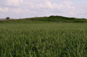
Cypress, sycamore, and cactus plants grew at the site, while surrounding village lands were cultivated.
This description derives from fieldwork conducted before the 1992 publication of All That Remains. It is therefore documented historical field evidence rather than a comprehensive direct verification of the condition of Aqir in 2026.
Sources
- PalQuest – Interactive Encyclopedia of the Palestine Question: Aqir
- PalQuest – Operation Barak and its chronology
- Palestine Remembered – Aqir, Ramla Subdistrict
- Palestine Remembered – Aqir entry from Walid Khalidi's All That Remains
- Palestinian Villages Encyclopedia – Aqir
- Sabil Library – Village Statistics 1945: Cultivable Land, Ramle Subdistrict
- Sabil Library – Village Statistics 1945: Built-up and Non-Cultivable Land, Ramle Subdistrict
- Government of Palestine – Census of Palestine 1931
- Government of Palestine – Census of Palestine 1922, digital copy hosted by WAFA
Photo gallery


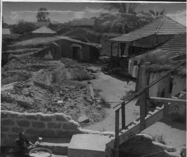


Photos from the village's people
Photos sent in by visitors and published after review.
Add a photo of this village
Log in to add photos of this village.
Other villages from Ramla

More from the archive


 Download Our Palestine App
The whole archive in the palm of your hand: depopulated villages, the Nakba, the massacres and Al-Aqsa — free, with no ads to erase the story.
Download Our Palestine App
The whole archive in the palm of your hand: depopulated villages, the Nakba, the massacres and Al-Aqsa — free, with no ads to erase the story.



Comments
No comments yet — be the first to write one.
Add your comment
Name and email are optional. Comments appear after review.