
The depopulated village of Ayn Karim / District of Al-Quds (Jerusalem)
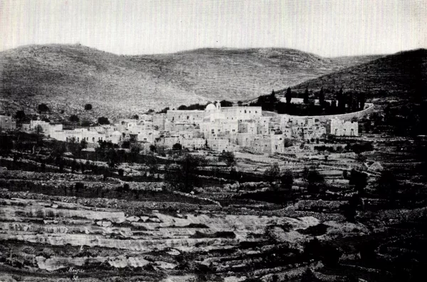
Subdistrict: Jerusalem
Estimated population of Ayn Karim in 1948: Approximately 3,690
Date of occupation and depopulation: 18 July 1948
Occupying military units: A combined force that included the Irgun, Gadna youth battalions, and the Home Guard
Israeli settlements established on Ayn Karim’s lands before 1948: None
Israeli settlements and neighbourhoods established on or incorporating village lands after 1948: Bayt Zayit, Even Sapir, and Kiryat Menachem
Ayn Karim was located approximately 7.5 kilometres west of Jerusalem, at an average elevation of about 650 metres above sea level.
The village was divided into two principal sections. The upper section consisted of agricultural terraces, while the lower section lay in a valley west of and below the upper quarter. The terraces extended from hills rising above the village to the east. Wadi Ahmad flowed westward across the village’s land and irrigated the olive groves in its northern section.
Ayn Karim was regarded as one of Jerusalem’s suburbs. A paved road connected it to the main Jerusalem–Jaffa highway, which passed approximately 3 kilometres north of the village.
During the early twentieth century, several people from Ayn Karim achieved prominent positions. Among them was Shaykh ‘Isa Mannun, who served as dean of the Faculty of Fundamentals of Religion at al-Azhar in 1944 and as dean of its Faculty of Islamic Law in 1946. Local historical accounts also identify Ayn Karim as a secret operational headquarters used by the Palestinian leader Abd al-Qadir al-Husayni during the 1936–1939 Palestinian Revolt.
Boundaries of Ayn Karim
Ayn Karim was surrounded by the following Palestinian villages and cities:
- To the north: Qalunya.
- To the northwest: Al-Qastal.
- To the west: Sataf.
- To the southwest: Al-Jura.
- To the southeast: Al-Maliha.
- To the east: Jerusalem.
- To the northeast: Deir Yasin.

Architectural Character of Ayn Karim
Ayn Karim was the largest village in the Jerusalem Subdistrict in terms of both land area and population. Its houses were generally built from limestone and chalk stone and were distinguished by arches framing their doors and windows.
Some of the larger houses were two or three storeys high. Their windows and doors were recessed within broad arched façades, while some doorways opened onto balconies with metal railings. Each of the village’s five principal hamulas had a courtyard where members gathered to socialize and celebrate family and community occasions.
Public Facilities, Education, and Cultural Life in Ayn Karim
Ayn Karim had two elementary schools, one for boys and another for girls, as well as a bookshop and a pharmacy. It also contained several athletic and social clubs and a scouting organization.
The villagers attended theatrical performances, including plays by the Palestinian artist and singer Nuh Ibrahim, who was exiled to Ayn Karim from northern Palestine because of his involvement in resistance to the British Mandate. The village also had an open-air cinema. A radio installed in the village coffeehouse was connected to loudspeakers, allowing large groups of residents to listen to news and other broadcasts.
A local council administered the village’s public affairs. Earlier educational institutions included a boys’ school established by the Franciscans and a school and orphanage for girls operated by the Sisters of Zion.
Economic Life in Ayn Karim
- Although Ayn Karim was situated in a mountainous area, it included flat agricultural land to the north, especially in the area known as al-Marj, where vegetables and fruit trees were cultivated. The villagers constructed terraces on the slopes to expand the cultivable area and planted olives, fruit trees, and grapevines.
- In 1944/45, 1,175 dunams of Palestinian-owned land were devoted to cereal cultivation, while 7,953 dunams were irrigated or used for orchards.
- In addition to agriculture, villagers worked in handicrafts and small-scale industries. Ayn Karim had a mineral-water bottling plant.
- Several springs supplied the village with drinking and agricultural water. Ayn Maryam was among the best-known springs.
Land Ownership in Ayn Karim, 1944/45
| Ownership category | Land area in dunams* |
|---|---|
| Palestinian ownership | 13,449 |
| Jewish ownership | 1,362 |
| Public land | 218 |
| Total | 15,029 |
* One dunam equals approximately 1,000 square metres.
Land Use in Ayn Karim, 1944/45
| Land-use category | Palestinian-owned land (dunams)* | Jewish-owned land (dunams)* | Public land (dunams)* | Total (dunams)* |
|---|---|---|---|---|
| Irrigated land and orchards | 7,953 | 7 | 0 | 7,960 |
| Olive groves* | 4,300 | 0 | 0 | 4,300 |
| Cereal cultivation | 1,175 | 24 | 0 | 1,199 |
| Built-up area | 1,007 | 680 | 17 | 1,704 |
| Cultivable land | 9,128 | 31 | 0 | 9,159 |
| Uncultivated land | 3,314 | 651 | 201 | 4,166 |
* The olive-grove figure is included within the irrigated-land and orchard category and should not be added separately to the cultivable-land total. One dunam equals approximately 1,000 square metres.
Population of Ayn Karim
In 1944/45, Ayn Karim had 3,180 Palestinian inhabitants, comprising 2,510 Muslims and 670 Christians. The population was organized into five principal hamulas, each of which had a courtyard where members and guests gathered for social meetings and private celebrations.
The village’s population was estimated at approximately 3,689–3,690 on the eve of its occupation in 1948. The number of refugees descended from the village population was estimated at approximately 22,653 in 1998.
Population Figures for Ayn Karim
| Year | Population* |
|---|---|
| 1596 | Approximately 160 |
| 1922 | 1,735 |
| 1931 | 2,637 |
| 1944/45 | 3,180 |
| 1948 estimate | Approximately 3,689–3,690 |
| Estimated descendant refugee population in 1998 | Approximately 22,653 |
* The 1596 figure is a historical estimate. The 1922 and 1931 figures are census results, while the 1944/45 figure comes from official British Mandate statistics. The 1948 and 1998 figures are demographic estimates. The 1931 total included Ayn al-Rawwas and Ayn al-Khandaq.
Origin of the Name and Religious Traditions
The Arabic name Ayn Karim may be understood as “the generous spring,” while related historical forms have also been associated with vineyards and cultivated gardens. Claims that the name means “the virgin” in Syriac are not supported by the principal linguistic and historical references.
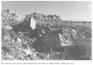
Archaeological evidence indicates that the village site was inhabited as early as the second millennium BCE. Two nearby khirbas contained building foundations, presses, water cisterns, and the remains of a fortified structure.
Christian tradition identifies Ayn Karim as the birthplace of John the Baptist. It also associates the village with the visit of Mary to her relative Elizabeth. These are religious traditions rather than independently established historical events. During the Crusader period, the village was known as St. Jehan de Bois.
Ayn Karim contained several Christian religious institutions, including the Church of John the Baptist, the Franciscan monastery, the Church of the Visitation, the Convent of Saint Zecharia, and the Church of the Lady of Zion. The village also contained a mosque associated with Caliph Umar ibn al-Khattab, with a minaret near Ayn Maryam.
Occupation and Depopulation of Ayn Karim
The displacement of Ayn Karim’s inhabitants occurred in stages during Israel’s occupation of Palestine—the Nakba. The massacre at nearby Deir Yasin on 9 April 1948 intensified fear throughout the western Jerusalem countryside and contributed to the departure of some families from Ayn Karim before the final assault.
During the period between 9 and 18 July 1948, Ayn Karim was encircled by a combined Israeli force that included members of the Irgun, the Gadna youth battalions, and the Home Guard. The village was bombarded from nearby hilltops overlooking its houses and agricultural terraces.
The final attack began at approximately 2:00 a.m. on 18 July, when Israeli forces stormed Jabal Rab, the height overlooking Ayn Karim. The village came under Israeli control later that morning. By that stage, most of the civilian population had already fled under the combined pressure of encirclement, bombardment, the fall of neighbouring Palestinian communities, and fear generated by the Deir Yasin massacre.
Sources differ over the exact day on which the village was fully emptied. Some accounts cite dates earlier in July, while the strongest documented chronology places the final occupation on 18 July 1948. The claim that substantial units of both the Arab Legion and the Egyptian army defended the village is considered unlikely by the Palestinian academic source consulted and has therefore not been presented as established fact.
Israeli Settlements and Institutions on Ayn Karim’s Lands
In 1949, Israel established Bayt Zayit and Even Sapir on land belonging to Ayn Karim. The Ayn Karim Agricultural School was established on village land in 1950.
Other parts of Ayn Karim’s land were annexed to the Israeli municipality of West Jerusalem. Sections of the confiscated land were subsequently incorporated into the expansion of western Jerusalem, including the area associated with Kiryat Menachem.
At the end of December 1948, the settlement of Jewish immigrants in the surviving Palestinian houses began, and approximately 150 families were initially placed in Ayn Karim. The village was then administratively incorporated into Israeli-controlled West Jerusalem.
Ayn Karim Today
Ayn Karim was one of the relatively few depopulated Palestinian villages whose architectural fabric largely survived the Nakba. Its Palestinian inhabitants were displaced, while Jewish families were settled in the surviving village houses.
A Palestinian Christian family displaced from Iqrit in the Acre Subdistrict in 1949 was later recorded as living in an old school building attached to the Franciscan monastery. The village retains a number of large limestone houses, Christian churches and monasteries, Christian and Muslim cemeteries, the mosque and its minaret, and the spring of Ayn Maryam.
The mosque has been left in a state of disrepair. The Muslim cemetery in the centre of the village has also suffered neglect. Hadassah Hospital and tourist facilities, including hotels and swimming pools, were constructed on or near the lands of the village.
Sources and References
- Interactive Encyclopedia of the Palestine Question: Ayn Karim
- Walid Khalidi, ed., All That Remains: The Palestinian Villages Occupied and Depopulated by Israel in 1948, Institute for Palestine Studies.
- BADIL Resource Center: Jerusalem 1948—The Fall of the New City
- BADIL Resource Center: Jerusalem and Its Rural Hinterland
- Palestine Remembered: Ayn Karim, Jerusalem Subdistrict
- Our Palestine: The Depopulated Palestinian Village of Ayn Karim
- Government of Palestine, Village Statistics, April 1945, population, land-ownership, and land-use tables for Ayn Karim.
Photo gallery


Photos from the village's people
Photos sent in by visitors and published after review.
Add a photo of this village
Log in to add photos of this village.
Other villages from Al-Quds (Jerusalem)
 Download Our Palestine App
The whole archive in the palm of your hand: depopulated villages, the Nakba, the massacres and Al-Aqsa — free, with no ads to erase the story.
Download Our Palestine App
The whole archive in the palm of your hand: depopulated villages, the Nakba, the massacres and Al-Aqsa — free, with no ads to erase the story.



Comments
No comments yet — be the first to write one.
Add your comment
Name and email are optional. Comments appear after review.