
The depopulated village of Al-Qubayba (Hebron) / District of Hebron
Subdistrict: Hebron
Estimated population in 1948: approximately 1,230 Palestinians
Date of occupation and depopulation: 28 October 1948
Military formation: Probably units of the Giv'ati or Har'el Brigade; the available documentation does not establish which brigade carried out the occupation conclusively.
Israeli settlements established on al-Qubayba’s lands before 1948: None
Israeli settlements established on al-Qubayba’s lands after 1948: Lakhish, established in 1955 southwest of the village site
Al-Qubayba was a depopulated Palestinian village in the Hebron Subdistrict. It was situated approximately 24 kilometres northwest of Hebron on a hill in the western foothills of the Hebron Mountains, at an average elevation of about 250 metres above sea level. Wadi Ghufr ran along the western foot of the hill.
The village was linked by a secondary road to the Hebron–Bayt Jibrin–al-Majdal highway, which passed northwest of the site, and by other local roads to neighbouring Palestinian villages. Its houses were constructed mainly of stone, mud, and adobe brick and stood along narrow streets radiating from the village centre.
Al-Qubayba’s Palestinian population was Muslim. The village contained a mosque, an elementary school, and several small shops. Two wells, situated northwest and southwest of the village, supplied its residents with drinking water.
Architectural Structure of al-Qubayba
Al-Qubayba was a comparatively large village built on a series of gently descending hills near a plain and surrounded by rocky, sparsely cultivated terrain. Its houses, made primarily of stone, mud, and adobe brick, were arranged along narrow streets that branched out from the centre into the village’s residential quarters.
The village’s principal communal buildings included its mosque and elementary school. A number of small shops served the residents’ everyday needs. The compact built-up area occupied approximately thirty-five dunams in 1944/45.
Boundaries and Neighbouring Localities
Al-Qubayba lay among the following Palestinian villages, towns, and tribal lands:
- North: Zikrin.
- Northwest: Iraq al-Manshiyya.
- Northeast: Bayt Jibrin.
- East and southeast: Idna and the lands extending towards the western Hebron hills.
- South and southwest: the lands of Palestinian Bedouin communities of the Beersheba region.
- Southeast: al-Dawayima.
The directions in the original account were internally inconsistent. They have been revised to reflect the relative locations shown in Palestinian village records; exact cadastral boundaries should be established from the official village-boundary maps.
Population of al-Qubayba
The village had 646 residents in the British census of 1922. Its population increased to 800 in 1931, when 141 inhabited houses were recorded. British Mandate statistics listed 1,060 Palestinian residents in 1945—not 1,960 as stated in one passage of the original article.
The population immediately before the village’s occupation during the Nakba has been retrospectively estimated at approximately 1,230. A further estimate placed the number of refugees from al-Qubayba and their descendants at approximately 7,551 in 1998. These 1948 and 1998 figures are demographic projections rather than contemporaneous census counts.
Population Record for al-Qubayba
| Year | Recorded or estimated population | Nature of figure |
|---|---|---|
| 1596 | Approximately 182 | Historical estimate derived from Ottoman tax records. |
| 1922 | 646 | British Mandate census. |
| 1931 | 800 | British Mandate census. |
| 1945 | 1,060 | British Mandate village statistics. |
| 1948 | Approximately 1,230 | Retrospective demographic estimate. |
| 1998 | Approximately 7,551 refugees and descendants | Retrospective demographic projection, not a census count. |
Number of Houses in al-Qubayba
| Year | Number of houses | Nature of figure |
|---|---|---|
| 1931 | 141 | Recorded in the British Mandate census. |
| 1948 | Approximately 216 | Retrospective estimate; no contemporaneous 1948 housing census has been identified. |
Village Facilities
Al-Qubayba contained several shops, a mosque, and an elementary school. The surrounding area was rich in archaeological remains, including a press cut into the rock and a number of ancient sites traditionally known as al-Saqifa al-Mudawwara, Qarqara, and Fara. The precise dates and functions of these remains have not been firmly established in the sources consulted.
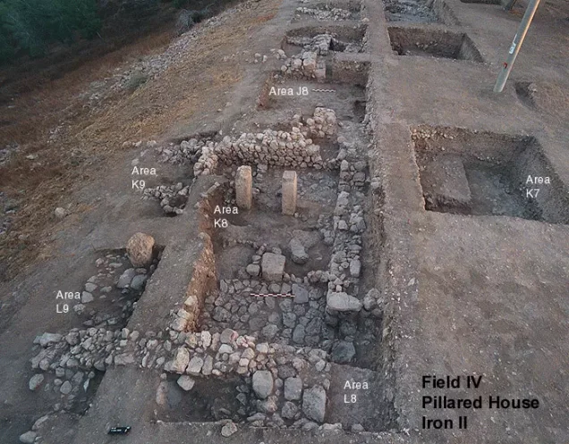
Immediately southwest of the village stood Tall al-Duwayr, identified with the ancient Canaanite city of Lachish. The site was occupied during several historical periods and was mentioned in the fourteenth-century BCE al-Amarna letters. British archaeological expeditions excavated Tall al-Duwayr between 1932 and 1938.
In addition to Tall al-Duwayr and the archaeological remains within al-Qubayba itself, at least fifteen archaeological locations were documented in the wider area associated with the village.
Land and Economy of al-Qubayba
- Al-Qubayba’s total cadastral area was 11,912 dunams, not eleven dunams as incorrectly stated in the original passage.
- The residents depended principally on rain-fed agriculture and livestock raising. They cultivated cereals, olives, grapes, and other fruit-bearing crops, while uncultivated areas provided seasonal grazing.
- In 1944/45, 8,109 dunams were classified as land used for cereal cultivation. Olive groves were reported to cover approximately forty-four dunams; this figure appears to describe an area within the broader cultivated classification and should not be added to the official total without qualification.
- Two wells situated northwest and southwest of the village provided drinking water.
- Under the United Nations partition proposal of 29 November 1947, al-Qubayba was located within the territory proposed for the Arab state. The proposal was not implemented as envisaged.
Land Ownership in al-Qubayba, 1944/45
| Ownership category | Area (dunams)* |
|---|---|
| Palestinian ownership | 11,801 |
| Jewish ownership | 0 |
| Public land | 111 |
| Total | 11,912 |
* One dunam equals approximately 1,000 square metres.
Land Use in al-Qubayba, 1944/45
| Land-use category | Palestinian-owned land (dunams)* | Public land (dunams)* | Total (dunams)* |
|---|---|---|---|
| Cereal cultivation | 8,109 | 0 | 8,109 |
| Built-up area | 35 | 0 | 35 |
| Uncultivated land | 3,657 | 111 | 3,768 |
| Total cadastral area | 11,801 | 111 | 11,912 |
* One dunam equals approximately 1,000 square metres.
Palestinian village records also report approximately forty-four dunams planted with olive trees. Because the principal Mandate land-use table records the entire cultivable area under cereal cultivation, the olive figure is presented separately rather than added to the totals above.
Occupation and Depopulation of al-Qubayba
Al-Qubayba was occupied on 28 October 1948 during the third stage of Operation Yoav, as Israeli forces expanded their territorial advances into the western Hebron foothills during the Nakba. Palestinian academic documentation states that the attacking formation probably belonged to either the Giv'ati Brigade or the Palmach’s Har'el Brigade. The available evidence does not conclusively establish which of the two occupied the village, and the unit should therefore not be identified more precisely as a verified fact.
The occupation occurred at approximately the same time as the assault on nearby al-Dawayima, where a massacre was carried out on 29 October 1948. The consulted sources do not provide a complete, independently verified account of what happened to al-Qubayba’s residents during the assault. What is documented is that the village was depopulated in connection with the military attack.
Some displaced residents of al-Qubayba reportedly sought refuge in the al-Dawayima area. Palestine Remembered records an account that refugees from al-Qubayba were among those killed in caves near al-Dawayima. However, the precise number and identities of these victims could not be confirmed from the other sources consulted and should not be presented as conclusively established.
Israeli Settlement on al-Qubayba’s Lands
The Israeli settlement of Lakhish was established in 1955 southwest of the former village site on land belonging to al-Qubayba. No Israeli settlement was established on the village’s lands before 1948.
Al-Qubayba Today
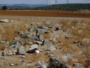
The village site is now marked principally by cactus plants and a small number of surviving olive trees. A neglected olive grove remains nearby, and some of its original stone terraces are still visible, although the area has been enclosed by fences.
Sources
- PalQuest: al-Qubayba — location, population, land, occupation, and present condition.
- Institute for Palestine Studies: Walid Khalidi, All That Remains.
- Palestine Remembered: al-Qubayba, Hebron Subdistrict.
- Sami Hadawi, Village Statistics of 1945: A Classification of Land and Area Ownership in Palestine.
- United Nations: Resolution 181 (II), Future Government of Palestine, 29 November 1947.
Photo gallery


Photos from the village's people
Photos sent in by visitors and published after review.
Add a photo of this village
Log in to add photos of this village.
Other villages from Hebron
 Download Our Palestine App
The whole archive in the palm of your hand: depopulated villages, the Nakba, the massacres and Al-Aqsa — free, with no ads to erase the story.
Download Our Palestine App
The whole archive in the palm of your hand: depopulated villages, the Nakba, the massacres and Al-Aqsa — free, with no ads to erase the story.



Comments
No comments yet — be the first to write one.
Add your comment
Name and email are optional. Comments appear after review.