
The depopulated village of Ghabat Kafr Sur / District of Tulkarm
Ghabat Kafr Sur
About the depopulated village of Ghabat Kafr Sur
- District
- Tulkarm
- Date Ghabat Kafr Sur was occupied
- 15 May 1948
- Population in 1948
- 858
- Military operation
- Coastal Clearing
- Distance from the governorate centre
- 16 (km) Southwest of Tulkarm
- Elevation above sea level
- 25 m
- Cause of displacement
- Fear of Jewish attack, or of being caught in the fighting
- Extent of destruction
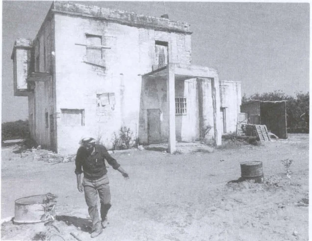
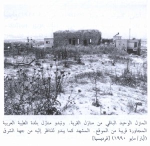
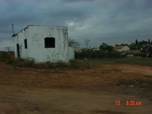
- Ghabat Kafr Sur was mostly destroyed with the exception of three deserted houses.
- Ethnic cleansing
- Ghabat Kafr Sur inhabitants were completely ethnically cleansed.
Hover a dot to read the village name, or click to open its card.
Borders of the depopulated village of Ghabat Kafr Sur
Ghabat Kafr Sur – Depopulated Palestinian Village of the Tulkarm Subdistrict
Ghabat Kafr Sur, also rendered Ghabat or Ghabat Kafr Sur in Palestinian community sources, was a Palestinian village in the Tulkarm Subdistrict. It stood on the coastal plain approximately 16 km southwest of Tulkarm at an average elevation of about 25 metres above sea level.
The village occupied level ground south of Khirbat Bayt Lid and Bayyarat Hannun. Coastal sands extended into its central and southern sections, forming rough sand dunes, while secondary roads linked the village with the main Jaffa–Haifa highway.
Ghabat Kafr Sur developed on land that had once formed part of the extensive Arsuf forest. Cultivators from Kafr Sur initially used the area seasonally, clearing trees and reclaiming land for agriculture until the locality gradually developed into a permanent Palestinian settlement.
Name of Ghabat Kafr Sur
PalQuest and Walid Khalidi use the singular Arabic form Ghabat Kafr Sur, while Palestine Remembered also uses the plural form Ghabat/Ghabat Kafr Sur in Arabic.
The word ghaba reflects the locality's origin within the extensive forest historically associated with Arsuf.
Kafr Sur refers to the parent village whose cultivators seasonally worked these lands before permanent settlement developed.
Location
Ghabat Kafr Sur stood on level coastal-plain terrain approximately 16 km southwest of Tulkarm and about 25 metres above sea level.
It lay south of Khirbat Bayt Lid and Bayyarat Hannun, while coastal sand dunes extended into much of its central and southern land.
Secondary roads linked the locality to the main Jaffa–Haifa highway and facilitated movement and the marketing of agricultural produce.
Origins of the Village
The village lands had originally formed part of the large Arsuf forest.
Residents of Kafr Sur came to the area seasonally to cultivate the land, clearing trees and converting woodland into agricultural fields and citrus groves.
As agricultural activity expanded, seasonal residence gradually developed into a permanent Palestinian community.
Water Resources
Wells and springs were abundant in the northern and eastern parts of Ghabat Kafr Sur.
The availability of water supported extensive agriculture, particularly citrus cultivation and irrigated orchards.
Population of Ghabat Kafr Sur
The population figures require a distinction between village-specific counts and combined statistical units.
- 1931559Official combined figure for Ghabat Kafr Sur, Bayyarat Hannun, and 'Arab al-Balawina; not Ghabat Kafr Sur alone.
- 1944/45740Official population of the Palestinian village of Ghabat Kafr Sur; the inhabitants were Muslims.
In the same 1944/45 statistics, Beyt Yahoshu'a had 180 Jewish inhabitants, Kefar Netter 90, and Tel Yitzchaq 120, for a combined Jewish population of 390 in the three settlements.
The figure of 1,130 sometimes displayed in secondary databases is therefore the combined total for Ghabat Kafr Sur and those three settlements, not the population of the Palestinian village itself.
Number of Houses
The 1931 census recorded 128 houses in the combined unit of Ghabat Kafr Sur, Bayyarat Hannun, and 'Arab al-Balawina.
No securely documented independent house count for Ghabat Kafr Sur alone is available from that census or immediately before the Nakba.
Land Ownership in 1944/45
The cadastral statistical unit combining Ghabat Kafr Sur with Beyt Yahoshu'a, Kefar Netter, and Tel Yitzchaq contained 19,666 dunums.
Using the ownership terminology employed by Palestine Remembered, while emphasizing that these are combined-unit figures:
- Palestinian4,506 dunums23%
- Transferred to Zionists10,384 dunums53%
- Communal4,776 dunums24%
In the official Government of Palestine classification, these correspond to 4,506 Arab dunums, 10,384 Jewish dunums, and 4,776 Public dunums.
Land Use in 1944/45
The following figures also apply to the combined Ghabat Kafr Sur–Beyt Yahoshu'a–Kefar Netter–Tel Yitzchaq statistical unit:
- Arab
- Jewish
- Public
- Citrus and Bananas1,639 dunums
- Plantations and Irrigable Land78 dunums
- Cereals11,475 dunums
- Built-up Area30 dunums
- Non-Cultivable Land6,444 dunums
Cultivated or cultivable land totalled 13,192 dunums, approximately 67 percent of the combined statistical unit, while built-up and non-cultivable land totalled 6,474 dunums.
This corrects simplified online tables that fold Public land into the Palestinian column. The official cereal breakdown is 2,700 Arab, 8,617 Jewish, and 158 Public dunums. Non-cultivable land was 431 Arab, 1,395 Jewish, and 4,618 Public dunums.
Citrus Acreage and the Differing Figure
Khalidi's descriptive narrative states that villagers had planted approximately 1,363 dunums with orange trees.
The official 1944/45 land-use table, however, records 1,333 Arab dunums under citrus and bananas.
This article therefore uses the official 1,333-dunum figure in the statistical table while preserving 1,363 as a separate descriptive figure reported in the historical narrative.
Economic Life
Agriculture was the foundation of Ghabat Kafr Sur's economy.
Citrus was especially important, while villagers also cultivated cereals, watermelons, pistachios, and orchard crops.
Numerous wells and springs in the northern and eastern sections of the locality supported citrus groves and other irrigated agriculture.
Agricultural development was the principal factor behind the transformation of the former forest zone from seasonally cultivated land into a permanent village.
Education and Public Services
The principal Khalidi/PalQuest entry does not securely document a formal school, mosque, clinic, or other specific public institution in Ghabat Kafr Sur immediately before the Nakba.
Institutions belonging to Kafr Sur, Bayyarat Hannun, or neighboring communities are therefore not transferred to the village without direct evidence.
Military Pressure on the Coastal Plain in 1948
Ghabat Kafr Sur lay within the central coastal zone that the Haganah General Staff considered strategically important to secure before the end of the British Mandate.
Khalidi records that Haganah commanders decided to “secure” the coastal area between Tel Aviv and Zikhron Ya'aqov by removing its entire Arab population before 15 May 1948.
During April and the first half of May, communities across this region were attacked or expelled, while others emptied as inhabitants fled in fear and isolation.
Depopulation of Ghabat Kafr Sur
Khalidi does not provide a precise date or village-specific narrative describing the exact moment when the inhabitants of Ghabat Kafr Sur left.
He cites nearby Khirbat Bayt Lid as an example of the regional atmosphere, where villagers left in early April because of fear and isolation.
The proximity of Ghabat Kafr Sur to large Zionist settlements and the Netanya area likely increased military pressure and insecurity.
By mid-May 1948, Khalidi states, the entire relevant coastal stretch had been emptied of its Palestinian Arab population.
Was Ghabat Kafr Sur Occupied on 15 May 1948?
Palestine Remembered lists 15 May 1948 as the occupation date.
Khalidi's detailed account does not document an attack or military entry into Ghabat Kafr Sur specifically on that date. Instead, he states that the circumstances of the village's occupation are unclear and that the surrounding coastal zone had become Arab-free by mid-May.
15 May should therefore not be treated as a securely documented battlefield occupation date.
The more precise formulation is: the inhabitants were displaced during April and the first half of May 1948; by approximately mid-May the village and surrounding coastal sector had been emptied of their Palestinian population; the exact village-specific date remains unknown.
“Coastal Clearing” and the Military Unit
Palestine Remembered uses the label “Coastal Clearing” for the campaign associated with Ghabat Kafr Sur.
Khalidi's detailed narrative describes a wider Haganah effort to clear the Palestinian coastal zone rather than a village-specific formally named operation with a documented attacking brigade and fixed date at Ghabat Kafr Sur.
The Haganah is the general military organization securely identified in the account, but no village-specific brigade or battalion is named.
The most precise formulation is therefore: military context: the Haganah campaign to clear the coastal zone; village-specific named operation: not established; village-specific brigade or battalion: unknown; cause of depopulation: military pressure, attacks in the surrounding region, fear, isolation, and the broader campaign to remove the Palestinian population.
Occupation and Depopulation Chronology
- April 1948
Expansion of the coastal-clearing campaign
The Haganah increasingly targeted Palestinian communities along the coastal sector between Tel Aviv and Zikhron Ya'aqov.
- Early April 1948
Departure from nearby Khirbat Bayt Lid
Its inhabitants left because of fear and isolation, illustrating the conditions affecting communities around Ghabat Kafr Sur.
- April–first half of May 1948
Attacks, expulsions, and flight along the coast
Palestinian communities were attacked or expelled, while others emptied through fear as Haganah control expanded.
- Exact date unknown
Depopulation of Ghabat Kafr Sur
The principal village entry does not document a precise day or a village-specific assault.
- By mid-May 1948
Completion of the clearing of the coastal sector
Khalidi states that the relevant coastal stretch had become devoid of its Palestinian Arab population.
Zionist Settlements Associated with Ghabat Kafr Sur Lands
Beyt Yahoshu'a and Tel Yitzchaq were established in 1938 on land purchased by the Jewish National Fund that had traditionally belonged to Ghabat Kafr Sur.
Kefar Netter was founded in 1939 approximately 2 km north of Beyt Yahoshu'a and was included with the other settlements in the statistical and cadastral unit used for Ghabat Kafr Sur in the 1944/45 land tables.
| Settlement | Founded | Relationship to Ghabat Kafr Sur |
|---|---|---|
| Beyt Yahoshu'a | 1938 | Founded on JNF-purchased land traditionally belonging to the village. |
| Tel Yitzchaq | 1938 | Founded on JNF-purchased land traditionally belonging to the village. |
| Kefar Netter | 1939 | Founded north of Beyt Yahoshu'a and included in the combined cadastral/statistical unit used in the 1944/45 village-land statistics. |
Khalidi does not identify a new post-1948 Israeli settlement as having been founded directly on the former village site itself. Later urban expansion should therefore not be added to this section without stronger village-specific cadastral documentation.
Ghabat Kafr Sur Today
In the historical field description published by Walid Khalidi in All That Remains, a large portion of the village site consisted of sand dunes covered with wild vegetation.
Several large eucalyptus trees grew across the site.
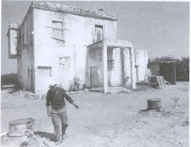
The remains of three large Palestinian houses were still visible among newly planted orange groves in the eastern and northeastern sections of the village site.
At the time of Khalidi's fieldwork, these surviving houses were being used as agricultural equipment warehouses.
This description predates the publication of All That Remains in 1992 and should therefore be treated as historical field documentation rather than direct and comprehensive verification of the site's condition or current building uses in 2026.
Sources
- PalQuest – Ghabat Kafr Sur
- Palestine Remembered – Ghabat Kafr Sur, Tulkarm
- Palestine Remembered – Ghabat Kafr Sur entry from Walid Khalidi's All That Remains
- Government of Palestine – Census of Palestine 1931
- Village Statistics 1944/45 – Sami Hadawi republication
- Institute for Palestine Studies – Walid Khalidi, All That Remains
Photo gallery
Photos from the village's people
Photos sent in by visitors and published after review.
Add a photo of this village
Log in to add photos of this village.
Other villages from Tulkarm
More from the archive
 Download Our Palestine App
The whole archive in the palm of your hand: depopulated villages, the Nakba, the massacres and Al-Aqsa — free, with no ads to erase the story.
Download Our Palestine App
The whole archive in the palm of your hand: depopulated villages, the Nakba, the massacres and Al-Aqsa — free, with no ads to erase the story.



Comments
No comments yet — be the first to write one.
Add your comment
Name and email are optional. Comments appear after review.