
The depopulated village of Ra'na / District of Hebron

About the depopulated village of Ra'na
- District
- Hebron
- Date Ra'na was occupied
- 22 October 1948
- Population in 1948
- 220
- Military operation
- Operation Yoav
- Brigade that carried it out
- Givati Brigade
- Distance from the governorate centre
- 26 كم شمال غربي الخليل
- Elevation above sea level
- 200 m
- Cause of displacement
- نتيجة إعتداء مباشر من القوات الصهيونية
- Extent of destruction
- دمرت بالكامل
- Ethnic cleansing
- لقد تم تطهير البلدة عرقياً بالكامل
- Settlements built on the land of Ra'na before 1948
- Gal On
Hover a dot to read the village name, or click to open its card.
Borders of the depopulated village of Ra'na
Ra'na – Depopulated Palestinian Village of the Hebron District
Ra'na was a depopulated Palestinian village in the Hebron District. It stood on the eastern slopes of the western foothills of the Hebron Mountains approximately 26 kilometers northwest of Hebron, at an average elevation of about 200 meters above sea level.
Ra'na was a small Muslim rural community whose economy depended on agriculture and livestock raising. Cereals were its principal crops in the late Mandate period, together with grapes, carob, and olives, while nineteenth-century descriptions also record tobacco and cotton.
The village fell to Israeli occupation forces on 22–23 October 1948 during the Giv'ati Brigade's advance through villages of the Hebron District, concurrent and coordinated with the late phase of Operation Yoav. Some inhabitants had already fled before the troops arrived, while those who remained were expelled toward Hebron.
Location and Geography
Ra'na stood on the eastern slopes of the western foothills of the Hebron Mountains.
It lay approximately 26 kilometers northwest of Hebron. Walid Khalidi and PalQuest give an average elevation of about 200 meters above sea level.
The Palestinian Encyclopedia describes the group of hills on which the village developed as rising to about 300 meters. This appears to refer to the surrounding hills or to a different geographical estimate, so this article uses 200 meters as the village's average elevation.
A secondary road passed through Ra'na, linking it southward with Kudna and Bayt Jibrin. To the northwest it led toward Dayr al-Dubban and 'Ajjur and ultimately joined the Jerusalem–Jaffa highway.
Supporting Palestinian documentation places Mughalis, Tall al-Safi, 'Ajjur, Zikrin, Zayta, Bayt Jibrin, Kudna, and Dayr al-Dubban around the village.
Name
Walid Khalidi does not provide a specific etymology for the name Ra'na.
Supporting Palestinian local documentation, citing Mustafa Murad al-Dabbagh, suggests a possible connection with the Arabic term al-ar'an, referring to crookedness or irregular form.
This remains a possible linguistic interpretation rather than a conclusively established historical derivation.
Ra'na in the Nineteenth Century
American scholar Edward Robinson passed the village in 1838 and recorded tobacco and cotton growing in its fields.
In the late nineteenth century, Ra'na was described as a village built of stone and mud with a pool and gardens.
Most houses were constructed of stone and roofed with timber and mud.
Built Environment
Ra'na was classified as a hamlet in the Mandate-era Palestine Index Gazetteer.
The houses formed a small cluster on the slope near agricultural land, the village pool, and the roads connecting the community with neighboring villages.
Based on the internally reconciled 1944/45 land-use figures, approximately 14 dunams were built-up.
Population and Houses
The inhabitants of Ra'na were Muslims.
- 1922126Official Census of Palestine; all inhabitants were Muslims
- 1931150Official census: 81 males and 69 females, all Muslims
- 1945190Official statistics; all inhabitants were Palestinian Arab Muslims
- 1948About 220Later demographic estimate, not an official Mandate census
- 1998About 1,354 refugees and descendantsLater estimate published by Palestine Remembered
The official 1931 census recorded 36 inhabited houses in Ra'na.
Some Palestinian local sources incorrectly give a 1931 population of 130. The official census records 150 inhabitants, which is the figure used here.
The estimate of approximately 52 houses in 1948 is a later calculation rather than an official Government of Palestine census figure.
Education and Religious Institutions
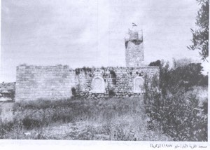
Walid Khalidi does not document an independent school or a specifically identified mosque in Ra'na.
Supporting Palestinian local documentation states that the village had neither a school nor a mosque and that some children attended the school in nearby Zikrin, which also served pupils from surrounding villages.
The local source describes that school as having four grades and one teacher.
These details are treated as supporting local documentation because they do not appear in Khalidi's principal village entry.
Water Resources and Archaeological Sites
Ra'na had a pool, while local Palestinian accounts also record rock-cut wells used to collect rainwater and water livestock.
Supporting local documentation identifies the shrine of Shaykh Ahmad east of the village and Khirbat Umm al-Shumar to the south, while Palestine Remembered also names Khirbat Qamha and Khirbat 'Amru.
Because secondary sources differ over the names of local khirbas, these are presented as supporting local details rather than a definitive archaeological inventory.
Economic Life and Agriculture
Agriculture and livestock raising formed the basis of Ra'na's economy.
Edward Robinson recorded tobacco and cotton cultivation in 1838.
By the late Mandate period, cereals were the principal crop, while villagers also cultivated grapes, carob, and olives.
In 1944/45, 5,882 dunams were devoted to cereals and 112 dunams were classified as plantations and irrigable land.
Palestine Remembered separately records 146 dunams of olive groves. This is a crop-specific figure and should not be added a second time to the official agricultural totals.
Land Ownership, 1944/45
The total land area of Ra'na was 6,925 dunams.
- Arab6,923 dunums100%
- Jewish0 dunums0%
- Public2 dunums<1%
The official ownership figures balance exactly: 6,923 + 2 = 6,925 dunams.
Palestine Remembered presents the corresponding figures using its own terminology: 6,923 dunams “Palestinian,” 0 dunams “Transferred to Zionists,” and 2 dunams “Communal/Public.”
The wording “Transferred to Zionists” should be preserved when reproducing that source's classification rather than automatically replacing it with the official “Jewish” category.
Land Use, 1944/45
- Arab
- Public
- Cereals5,882 dunums
- Plantations and irrigable land112 dunums
- Total cultivable/cultivated land5,994 dunums
- Non-cultivable land917 dunums
- Built-up land14 dunums
- Total non-cultivable and built-up931 dunums
The reconciled table balances exactly: 5,994 dunams of cultivated or cultivable land plus 931 dunams of built-up and non-cultivable land equal the village's total area of 6,925 dunams.
The PalQuest display contains an apparent numerical formatting error: it gives 12 dunams as built-up while simultaneously retaining an Arab non-cultivable-and-built-up subtotal of 929 dunams.
Since 915 + 14 = 929, and Palestine Remembered gives 14 built-up dunams, 14 is the internally consistent figure used here.
Military Developments in October 1948
Operation Yoav began on 15 October 1948 with the objective of breaking Egyptian lines and linking Israeli forces in the Negev with forces positioned farther north.
The Giv'ati Brigade played a major role on the southern front, and during the final week of October operations expanded northward toward the Hebron hills.
PalQuest records that the operational zones merged after Israeli units broke through Egyptian lines on 23 October and connected Israeli-held areas of the Hebron hills with the Jerusalem corridor.
Occupation of Ra'na
The Giv'ati Brigade stormed a number of villages in the Hebron District, and Ra'na fell to Israeli occupation forces on 22–23 October 1948.
Many inhabitants of Ra'na and other villages in the hills around Hebron had already fled before Israeli troops reached them.
Those who remained in Ra'na were expelled toward Hebron.
Ra'na and Operation Yoav
Palestine Remembered and several later sources classify Ra'na under Operation Yoav.
Khalidi's wording is more precise: he states that the Giv'ati Brigade was storming villages in the Hebron District while other Israeli forces were carrying out Operation Yoav farther south.
At the same time, PalQuest's Operation Yoav entry explains that the operational zones merged during the final week of October, especially after the breakthrough of 23 October.
The most accurate formulation is therefore that Ra'na was captured during Giv'ati's northward advance concurrent and coordinated with the late phase of Operation Yoav and within its broader operational framework, without claiming that a separate village-level assault explicitly named “Operation Yoav” is documented for Ra'na itself.
Military Unit
The formation securely documented at village level was the Giv'ati Brigade.
Khalidi's Ra'na entry does not identify a particular battalion.
The village should therefore not be assigned to Giv'ati's First, Fourth, or any other battalion merely by analogy with neighboring villages.
Occupation Chronology
- 15 October 1948
Beginning of Operation Yoav
Israeli forces launched a broad southern offensive intended to break Egyptian lines and connect the Negev with Israeli-held territory farther north.
- Second half of October 1948
Giv'ati advance toward the Hebron hills
The Giv'ati Brigade began overrunning villages in the Hebron District while operations continued farther south.
- 22 October 1948
Beginning of Ra'na's fall
Giv'ati forces reached the village area; a substantial portion of the population had already fled.
- 22–23 October 1948
Occupation and final displacement
Ra'na fell to the Giv'ati Brigade, and those inhabitants who remained were expelled toward Hebron.
- 23 October 1948
Merging of operational zones
Israeli forces broke through Egyptian lines and linked Israeli-held areas of the Hebron hills with the Jerusalem corridor during the late phase of Operation Yoav.
- After occupation; exact date not documented
Destruction
The village buildings were subsequently removed so completely that no houses or visible rubble remained at the time of Khalidi's field survey.
Zionist and Israeli Settlements on Village Lands
In 1946, the Zionist settlement of Gal-On was established on land traditionally regarded as belonging to Ra'na.
Because it was founded before the establishment of Israel and before the Nakba, Gal-On was a pre-1948 Zionist settlement on village land.
Khalidi does not identify a new post-1948 settlement established directly on the former built-up site of Ra'na.
Ra'na Today
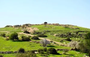
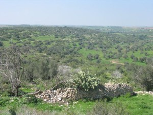
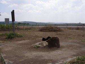
According to the field description published in Walid Khalidi's All That Remains, the former village site was enclosed by barbed wire.
Cactuses covered parts of the site, particularly areas with limestone soil, and carob trees were scattered across it.
No village houses or visible rubble remained.
This description should not be treated as a comprehensive field verification of conditions in 2026. Fieldwork for All That Remains was conducted between 1987 and 1990 and therefore records the site's condition during that survey period.
Sources
- PalQuest – Interactive Encyclopedia of the Palestine Question: Ra'na
- PalQuest – Operation Yoav
- Palestine Remembered – Ra'na, Hebron District
- Palestine Remembered – Walid Khalidi's account of Ra'na
- Palestinian Villages Encyclopedia – Ra'na; supporting Palestinian local documentation
- Falastinuna – Ra'na, Hebron District
- Palestinian Encyclopedia – Ra'na
- Government of Palestine – Census of Palestine 1931: Ra'na, 150 inhabitants in 36 houses
- Village Statistics 1945 – Population and Land Ownership, Hebron Sub-District
- Village Statistics 1945 – Land Use in Ra'na
- Institute for Palestine Studies – Walid Khalidi, All That Remains
- PalQuest – All That Remains: Methodology and Fieldwork
Photo gallery

Photos from the village's people
Photos sent in by visitors and published after review.
Add a photo of this village
Log in to add photos of this village.
Other villages from Hebron
More from the archive
 Download Our Palestine App
The whole archive in the palm of your hand: depopulated villages, the Nakba, the massacres and Al-Aqsa — free, with no ads to erase the story.
Download Our Palestine App
The whole archive in the palm of your hand: depopulated villages, the Nakba, the massacres and Al-Aqsa — free, with no ads to erase the story.



Comments
No comments yet — be the first to write one.
Add your comment
Name and email are optional. Comments appear after review.