
The depopulated village of Al-'Imara / District of Bir-a-Saba (Beer Sheva)
About the depopulated village of Al-'Imara
- District
- Bir-a-Saba (Beer Sheva)
- Distance from the governorate centre
- 27 (km) North of Beersheba
- Elevation above sea level
- 100 m
- Extent of destruction
- The village was completely defaced and built over.
- Ethnic cleansing
- al-'Imara inhabitants were completely ethnically cleansed.
- Settlements built on the built-up area of Al-'Imara after 1948
- Urim
Hover a dot to read the village name, or click to open its card.
Al-'Imara – Depopulated Palestinian Village of the Beersheba Subdistrict
Al-'Imara was a small Palestinian locality in the Beersheba Subdistrict, approximately 27 kilometers northwest of Beersheba, on the northern edge of the Naqab. Its average elevation was about 100 meters above sea level.
The Palestine Index Gazetteer classified al-'Imara as a small hamlet or inhabited agricultural locality. Walid Khalidi included it among the Palestinian villages depopulated in 1948, and subsequent field research confirmed that it met the criteria of a distinct pre-1948 locality.
- Subdistrict
- Beersheba
- Mandate District
- Gaza
- Type of Locality
- Small hamlet / inhabited agricultural locality according to the Palestine Index Gazetteer
- Distance from Beersheba
- Approximately 27 km
- Direction
- Northwest of Beersheba
- Average Elevation
- Approximately 100 meters
- Population in 1922
- No independently documented al-'Imara-specific figure established
- Population in 1931
- No independently documented al-'Imara-specific figure established
- Population in 1944/1945
- No independently documented village-specific figure established
- Estimated Population in 1948
- 46 according to Salman Abu Sitta's Register – a later estimate, not an official census
- Total Land Area
- No independent reliable total established from the principal sources
- Occupation / Depopulation Date
- Disputed; later lists give May 1948, while Khalidi's detailed account points to a major expulsion phase in the area in late September–early October 1948
- Military Operation
- No securely identified named major operation; two clearing operations occurred in the area during the Second Truce
- Most Directly Documented Unit
- Third Battalion of the Yiftach Brigade during the late-September/early-October phase; Palmach forces had earlier seized the British police station
- Cause of Displacement
- Military operations and expulsion from the surrounding area; the cited brigade report described removal of residents, confiscation of livestock, and destruction of wells
- Extent of Destruction
- The original village site is now built over by Urim; no reliable numerical destruction percentage is available
- Post-1948 Settlement
- Urim
Location
Al-'Imara stood in a broad, relatively flat area in the northern Naqab, approximately 27 kilometers from Beersheba.
Secondary roads connected the locality with Beersheba and Gaza. Khalidi's description places Gaza approximately 22 kilometers to the north.
The average elevation of al-'Imara was approximately 100 meters above sea level.
Wadi al-Shalala and 'Ayn al-Shalala
Wadi al-Shalala was one of the principal natural features near the locality. Its seasonal watercourse passed approximately 2.5 kilometers west of al-'Imara.
The spring of 'Ayn al-Shalala was likewise located to the west and formed part of the local water and agricultural environment.
Climate and Agriculture
The al-'Imara region was arid, receiving approximately 200–300 millimeters of rainfall annually.
Regular rain-fed agriculture was therefore difficult. Khalidi suggests that the inhabitants depended substantially on seasonal cultivation in nearby wadi beds, where runoff and residual moisture made cultivation possible after rainfall.
The residents cultivated land both north and south of the village site.
No independent crop-acreage table has been established for al-'Imara.
Population
Al-'Imara does not have a continuous independent population series in the principal Mandate censuses comparable to that available for many larger settled Palestinian villages.
No securely verified al-'Imara-specific total is therefore used for 1922, 1931, or 1944/45.
Salman Abu Sitta's Register gives an estimated 46 inhabitants for al-'Imara in 1948.
| Year | Population | Nature of Figure |
|---|---|---|
| 1922 | Not independently available | No unsupported estimate used |
| 1931 | Not independently available | No verified village-specific total established |
| 1944/1945 | Not independently available | No independent village population table established |
| 1948 | 46 | Retrospective estimate in Salman Abu Sitta's Register, not an official census |
The 1948 Estimate of 46
Salman Abu Sitta includes al-'Imara among the Beersheba localities and gives 46 as its 1948 Arab population.
The figure should be treated as a later demographic estimate rather than a formal 1948 census.
Abu Sitta's methodological discussion notes that his expanded Beersheba list also includes small communities connected with police stations, which often contained permanent structures and populations commonly ranging from roughly forty to one hundred people.
WAFA reproduces the figure of 46, while some later Palestinian databases round the figure to approximately 50.
Land and Property
The principal sources reviewed do not provide a complete independent al-'Imara land total from which a standard 1945 ownership table can be reliably reconstructed.
No Palestinian / Transferred to Zionists / Communal-Public table is therefore supplied, nor are unsupported crop and orchard figures added.
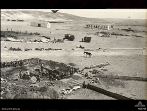
The British Police Station
During the British Mandate, a police station was constructed on al-'Imara land approximately one kilometer south of the locality.
This installation became important in the military history of 1948. Khalidi reports that Palmach forces occupied the station after the British withdrew and before 15 May 1948.
Control of the police station, however, does not by itself prove that the entire village was permanently depopulated at the same moment.
Early Fighting around al-'Imara
The earliest clearly documented military incident in the sources reviewed occurred on 26 December 1947.
A contemporary report described a small clash in the vicinity of al-'Imara between a Zionist patrol and local residents.
This indicates that armed confrontation around the locality began during the earliest phase of the 1947–1949 war.
Disagreement over the Depopulation Date
The available Palestinian sources do not agree on one final depopulation date.
WAFA gives 13 May 1948, alongside the estimated population of 46.
The Encyclopedia of Palestinian Villages provides a different date, 3 May 1948, and associates the locality with the Yiftach Brigade.
Walid Khalidi's fuller narrative does not conclusively establish either May date as the village's final depopulation.
It acknowledges the possibility of early Israeli control following the Palmach takeover of the police station, while also documenting a clearer and more extensive expulsion phase in late September and early October.
Yiftach Brigade Operations, Late September–Early October 1948
During the Second Truce, Israeli forces took control of a broad area around al-'Imara between the end of September and the first days of October 1948.
The Third Battalion of the Yiftach Brigade carried out two clearing operations in the area.
Khalidi's account cites a brigade report stating that Arab residents were expelled from the area, livestock was confiscated, and wells were destroyed.
The same source nevertheless notes that the available record does not conclusively identify the precise day on which al-'Imara itself was occupied.
Was There a Named Operation?
The principal village source does not establish one named major operation, such as Operation Yoav, as the operation that captured al-'Imara.
The best-supported sequence is instead:
- Early Palmach seizure of the British police station before 15 May 1948.
- Two clearing operations by the Third Battalion of the Yiftach Brigade in the al-'Imara region during the Second Truce, in late September and early October.
No additional named operation is assigned without direct village-specific documentation.
Occupation and Displacement Chronology
- 26 December 1947
First Documented Clash
A small armed clash occurred near al-'Imara between a Zionist patrol and local residents.
- Before 15 May 1948
Seizure of the Police Station
Palmach forces took over the British police station on al-'Imara land after the British withdrawal.
- 13 May 1948
Early Date in Later Lists
WAFA uses this depopulation date, but Khalidi's detailed account does not conclusively confirm it.
- Late September – early October 1948
Large-Scale Control of the Surrounding Area
The Third Battalion of the Yiftach Brigade conducted two clearing operations in the region; the cited brigade report described expulsion of Arab residents, seizure of livestock, and destruction of wells.
- By the end of 1948
Confirmed Israeli Control
Al-'Imara and its immediate surroundings were firmly under Israeli control.
- Early January 1949
Golani Brigade Base
The Golani Brigade used al-'Imara and its surroundings as a base for an unsuccessful operation toward Rafah; this was a later stage, not the village's occupation event.
Military Unit
Three different military formations appear at different stages and should not be conflated:
- Palmach: occupied the British police station before 15 May 1948.
- Third Battalion, Yiftach Brigade: carried out the best-documented late-September/early-October clearing operations around al-'Imara and is therefore the unit most directly associated with the final displacement phase.
- Golani Brigade: established a base in the area in January 1949, after al-'Imara was already under Israeli control.
The most cautious formulation is therefore: the Third Battalion of the Yiftach Brigade is the best-documented unit associated with the final displacement phase, although the exact village-specific occupation date remains uncertain.
Cause of Displacement
The displacement of al-'Imara's inhabitants was directly connected with military operations in the area.
Khalidi's account refers to the removal of Arab inhabitants during Yiftach Brigade operations, together with confiscation of livestock and destruction of wells.
The most supportable description is therefore military attack and expulsion during the Israeli takeover of the al-'Imara area, while acknowledging disagreement over the precise date on which the village itself became completely depopulated.
Extent of Destruction
No reliable numerical destruction percentage is available.
Walid Khalidi's site description states that the original al-'Imara village site was subsequently built over by Urim.
The Palestinian village therefore ceased to survive as a distinct built-up locality.
Urim on al-'Imara Land
Urim was originally established in 1946 near al-'Imara, before the Nakba.
During the 1948 war it was moved to the site of the former British police station on al-'Imara land, approximately one kilometer south of the village site.
The later settlement expanded over the original al-'Imara site.
Al-'Imara Today
The available description of the site is based mainly on historical fieldwork incorporated into Walid Khalidi's All That Remains and photographs from around 1990. It is therefore not a direct 2026 field verification.
According to that description, the original al-'Imara site had been completely built over by Urim and no longer survived as an identifiable Palestinian village center.
Approximately two kilometers southeast of present-day Urim, several stone-building remains were visible. Khalidi specifically notes that these were houses of Bedouin families before 1948 and were not considered part of al-'Imara itself.
Those structures should therefore not be described as surviving al-'Imara village houses without this qualification.
Sources
- PalQuest – Interactive Encyclopedia of the Palestine Question: al-'Imara
- Institute for Palestine Studies – Walid Khalidi, All That Remains
- Palestine Remembered – al-'Imara, Beersheba
- Palestine Remembered – al-'Imara entry from All That Remains
- Salman Abu Sitta – The Palestinian Nakba 1948: Register of Depopulated Localities
- Palestine Land Society – Abu Sitta's Methodology for the Expanded Depopulated Localities Register
- WAFA – Palestinian Localities Depopulated in 1948: Arab al-'Imara
Photos from the village's people
Photos sent in by visitors and published after review.
Add a photo of this village
Log in to add photos of this village.
Other villages from Bir-a-Saba (Beer Sheva)
More from the archive
 Bir-a-Saba (Beer Sheva)
The depopulated village of Asluj / District of Bir-a-Saba (Beer Sheva)
Bir-a-Saba (Beer Sheva)The depopulated village of Sawakhneh / al-Azazmeh / District of Bir-a-Saba (Beer Sheva)
Bir-a-Saba (Beer Sheva)The depopulated village of Farahin / al-Azazmeh / District of Bir-a-Saba (Beer Sheva)
 Download Our Palestine App
The whole archive in the palm of your hand: depopulated villages, the Nakba, the massacres and Al-Aqsa — free, with no ads to erase the story.
Download Our Palestine App
The whole archive in the palm of your hand: depopulated villages, the Nakba, the massacres and Al-Aqsa — free, with no ads to erase the story.



Comments
No comments yet — be the first to write one.
Add your comment
Name and email are optional. Comments appear after review.