
The depopulated village of Khirbat al-Wa'ara al-Sawda / District of Tiberias
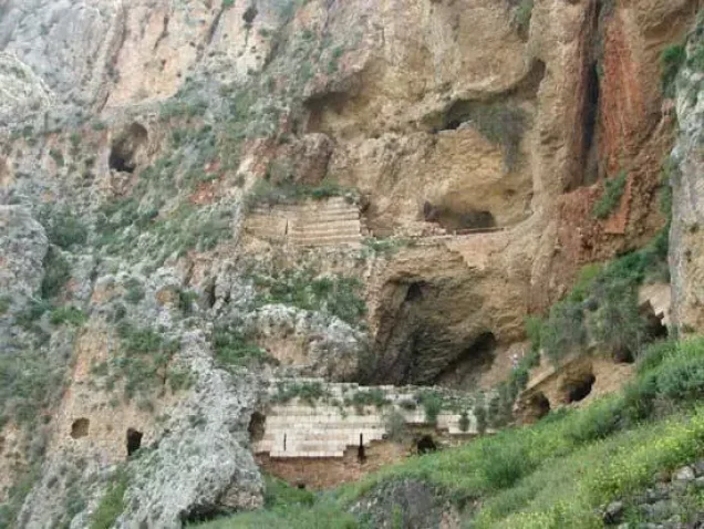
Khirbat al-Wa'ara al-Sawda
About the depopulated village of Khirbat al-Wa'ara al-Sawda
- District
- Tiberias
- Date Khirbat al-Wa'ara al-Sawda was occupied
- 18 April 1948
- Population in 1948
- 2,170
- Military operation
- Operation Dekel
- Distance from the governorate centre
- 7.5 (km) Northeast of Tiberias
- Elevation above sea level
- 25 m
- Cause of displacement
- Expulsion by Zionist troops
- Extent of destruction
- The village was completely obliterated
- Ethnic cleansing
- al-Wa'ra al-Sawda', Khirbat inhabitants were completely ethnically cleansed.
- Refugees' migration routes
- Some of 'Arab al-Mawasi escaped to Syria and some stayed behind in the inner Galilee.
Hover a dot to read the village name, or click to open its card.
Borders of the depopulated village of Khirbat al-Wa'ara al-Sawda
Khirbat al-Wa'ra al-Sawda': A Depopulated Palestinian Hamlet in the Tiberias District
Khirbat al-Wa'ra al-Sawda' was a Palestinian hamlet in the Tiberias District. It stood on a small plateau of volcanic rock overlooking Wadi al-Hamam and Lake Tiberias, approximately 7.5 km from Tiberias and at an average elevation of about 25 metres above sea level. Most of its inhabitants belonged to the Bedouin 'Arab al-Mawasi, while some families belonged to 'Arab al-Wuhayb. They were displaced during the Nakba and the occupation of Palestine in 1948. The precise date of the hamlet's occupation remains uncertain: Walid Khalidi presents two possibilities, either after the fall of Tiberias in April or during Operation Dekel in July 1948.
Location of Khirbat al-Wa'ra al-Sawda'
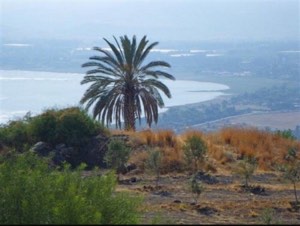
The hamlet stood on a small plateau of volcanic rock overlooking Wadi al-Hamam and Lake Tiberias.
It was approximately 7.5 km from Tiberias and had an average elevation of about 25 metres above sea level.
The Palestine Index Gazetteer classified the locality as a hamlet rather than a large village or town.
A secondary road connected it with the highway running along the shore of Lake Tiberias toward the city, while a dirt road linked it with the Palestinian village of Hittin to the southwest.
The stone houses were grouped irregularly around the intersection of these two roads.
Population and Community
Most inhabitants belonged to the Bedouin 'Arab al-Mawasi, while a smaller number of families belonged to 'Arab al-Wuhayb.
Some families had built permanent stone houses, while Bedouin households that had not yet constructed permanent dwellings lived in tents surrounding them.
All of the inhabitants were Muslim.
The Mandate population and house figures include 'Arab al-Mawasi and 'Arab al-Wuhayb and should not be interpreted as referring solely to the cluster of permanent stone houses.
Architecture and Religious Life
The village houses were arranged irregularly around the intersection of the road toward Tiberias and the dirt road leading toward Hittin.
Bedouin tents belonging to families without permanent homes stood around the stone houses.
A khirba on the northern outskirts contained two shrines dedicated to local shaykhs, 'Umar and Musa al-Qadhim.
The inhabitants held religious ceremonies at the shrine of Musa al-Qadhim.
Education
The principal approved sources used for this article do not provide sufficiently documented information about an independent school in Khirbat al-Wa'ra al-Sawda' before the Nakba.
No unverified educational details are therefore added.
Economic Life
Agriculture was the principal economic activity alongside the pastoral way of life associated with the Bedouin population.
Olive trees were planted in the northern parts of the village lands, while cereals were cultivated in the bed of Wadi al-Hamam.
In 1944/45, 2,027 dunums were devoted to cereal cultivation.
The official tables used here do not provide a separate acreage for olive cultivation, so no unsupported figure is assigned to it.
Land Ownership in Khirbat al-Wa'ra al-Sawda'
The total registered land area was 7,036 dunums in the 1944/45 statistics. The figures include 'Arab al-Mawasi and 'Arab al-Wuhayb.
Land ownership in Khirbat al-Wa'ra al-Sawda', 1944/45
- Palestinian7,036 dunums100%
- Transferred to Zionists0 dunums0%
- Communal0 dunums0%
The Arabic Palestine Remembered page and PalQuest record all 7,036 dunums as Palestinian/Arab land, with no land in the categories “Transferred to Zionists” or communal.
The English Palestine Remembered summary contains an apparent internal typographical inconsistency in its ownership table while retaining the same total of 7,036 dunums. The figures above therefore follow the internally consistent Arabic page and PalQuest data.
Land Use, 1944/45
Land use in Khirbat al-Wa'ra al-Sawda'
- Palestinian
- Cereals2,027 dunums
- Built-up area10 dunums
- Non-cultivable land4,999 dunums
Cereal land amounted to 2,027 dunums, approximately 29 percent of the total.
Built-up and non-cultivable land together amounted to 5,009 dunums, approximately 71 percent of the registered area.
Population of Khirbat al-Wa'ra al-Sawda'
Population in selected years
- 19311,060Official Mandate census; includes 'Arab al-Mawasi and 'Arab al-Wuhayb
- 1944/451,870Official statistics
- 19482,169Later estimate published by Palestine Remembered
- Estimated refugees in 199813,321Later estimate published by Palestine Remembered
Number of Houses
Number of houses in 1931
- 1931190Includes 'Arab al-Mawasi and 'Arab al-Wuhayb
Palestine Remembered's English page further divides the 190 houses into 161 associated with 'Arab al-Mawasi and 29 with 'Arab al-Wuhayb.
No official 1948 house count is provided by the principal approved sources used here.
Archaeological Sites and Shrines
Several archaeological localities lay near the hamlet. Two khirbas contained old building foundations, stone cairns, cisterns, a cave, a well, and a trough hewn into the rock.
Palestine Remembered identifies one archaeological locality as Khirbat al-Mazqa and describes foundations, heaps of stone, a cave, and a rock-cut well.
The shrines of Shaykh 'Umar and Shaykh Musa al-Qadhim stood on the northern outskirts, and the latter was associated with religious ceremonies performed by the villagers.
Occupation and Depopulation during the Nakba
Walid Khalidi states that no published account definitively establishes when or how Khirbat al-Wa'ra al-Sawda' was occupied.
He therefore presents two principal possibilities.
The first is that the Haganah occupied the hamlet in the aftermath of the fall of Tiberias on 18 April 1948. After taking the city, Haganah forces raided several surrounding Palestinian villages in order to consolidate their control and drive the population from the Tiberias hinterland.
The second possibility is that the hamlet remained outside Israeli control until Operation Dekel in July 1948 and was occupied as forces that had taken Nazareth advanced eastward toward Tiberias, at approximately the same time as nearby Hittin fell.
PalQuest's Operation Dekel database lists Khirbat al-Wa'ra al-Sawda' among the villages affected by the operation. Operation Dekel took place from 8 to 18 July 1948 and involved the Sheva', Golani, and Carmeli brigades.
The principal sources do not, however, identify which of these brigades, if any, specifically occupied Khirbat al-Wa'ra al-Sawda'. No village-specific unit should therefore be asserted.
Palestine Remembered's summary lists 18 April 1948 as the occupation date while also associating the village with Operation Dekel. Because Operation Dekel occurred in July, these two entries are not chronologically consistent and should not be combined into a single certain account.
- Precise occupation date: uncertain.
- First possibility: 18 April 1948, following the fall of Tiberias.
- Second possibility: mid-July 1948 during Operation Dekel.
- Operation Dekel: 8–18 July 1948.
- Brigades involved in Operation Dekel overall: Sheva', Golani, and Carmeli.
- Village-specific occupying unit: not established.
- Fate of the population: displaced during the Nakba; some members of 'Arab al-Mawasi later fled to Syria, while others joined Bedouin communities in the inner Galilee.
The Massacre of 'Arab al-Mawasi near Eilabun
Walid Khalidi records an oral account of a massacre involving men from 'Arab al-Mawasi in late October or early November 1948, after the second truce.
According to the account, Israeli occupation soldiers rounded up fifteen men from 'Arab al-Mawasi and took them toward the village of Eilabun, where they were shot.
After the first volley, two men remained alive or successfully feigned death. The soldiers later returned and fired again at the bodies. Fourteen of the fifteen men were ultimately killed.
The dead were buried in a nearby cave. The sole survivor escaped to Syria with some members of 'Arab al-Mawasi, while others joined Bedouin groups in the inner Galilee.
This episode must be distinguished from the Eilabun massacre of 30 October 1948, which targeted inhabitants of Eilabun itself. The account preserved in the Khirbat al-Wa'ra al-Sawda' entry concerns men from 'Arab al-Mawasi who were taken toward the Eilabun area; the two events should not be merged into a single massacre.
The principal source explicitly presents the 'Arab al-Mawasi account as oral testimony, and its details are therefore reported with that qualification.
Israeli Settlements and the Village Lands
Walid Khalidi does not identify an Israeli civilian settlement established directly on Khirbat al-Wa'ra al-Sawda's lands.
- Ravid lies approximately 3 km west of the site but is not on the village lands.
- Arbel, established in 1949 about 2 km southeast of the site, was built on the lands of the depopulated Palestinian village of Hittin rather than on the lands of Khirbat al-Wa'ra al-Sawda'.
Neither Ravid nor Arbel should therefore be listed as a settlement established on the village's own lands.
Khirbat al-Wa'ra al-Sawda' Today
According to the field description published by Walid Khalidi in All That Remains, no identifiable traces of the village houses remained, and stone terraces were the principal indication that a Palestinian settlement had once stood at the site.
The village site and surrounding lands were used for grazing, while parts of the land were cultivated.
Palestine Remembered contains later user-contributed photographic documentation. Photographs dated 2007 are captioned as showing surviving traces and stones from demolished houses, while photographs from 2012 are captioned as showing limited wall and house remains, village paths, graves, and fragments of stone-and-concrete structures.
Some of these captions are more specific than Khalidi's earlier field description, which stated that no house traces remained. The photographs and captions, however, are individual user contributions rather than a systematic independent archaeological or field survey.
The principal description here therefore continues to rely on Khalidi's field research while noting that later contributed material may indicate limited surviving structural remains. The approved sources used here do not provide a sufficiently comprehensive and independent 2026 field survey to verify the precise condition of every part of Khirbat al-Wa'ra al-Sawda' today.
Sources
- PalQuestPalQuest – Interactive Encyclopedia of the Palestine Question: Khirbat al-Wa'ra al-Sawda'
- PalQuestPalQuest – Operation Dekel
- Palestine RememberedPalestine Remembered – Khirbat al-Wa'ra al-Sawda', Tiberias District
- Palestine RememberedPalestine Remembered – Khirbat al-Wa'ra al-Sawda' entry from All That Remains
- Institute for Palestine StudiesInstitute for Palestine Studies – All That Remains, Walid Khalidi
Photo gallery


Photos from the village's people
Photos sent in by visitors and published after review.
Add a photo of this village
Log in to add photos of this village.
Other villages from Tiberias
More from the archive


 Download Our Palestine App
The whole archive in the palm of your hand: depopulated villages, the Nakba, the massacres and Al-Aqsa — free, with no ads to erase the story.
Download Our Palestine App
The whole archive in the palm of your hand: depopulated villages, the Nakba, the massacres and Al-Aqsa — free, with no ads to erase the story.



Comments
No comments yet — be the first to write one.
Add your comment
Name and email are optional. Comments appear after review.