
The depopulated village of Nimrin / District of Tiberias
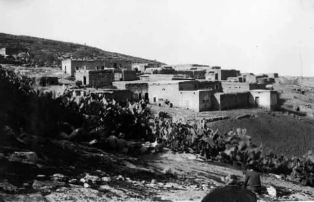
About the depopulated village of Nimrin
- District
- Tiberias
- Date Nimrin was occupied
- 16 July 1948
- Population in 1948
- 371
- Military operation
- Operation Dekel
- Distance from the governorate centre
- 10.5 (km) Northwest of Tiberias
- Elevation above sea level
- 350 m
- Cause of displacement
- Military assault by Zionist troops
- Extent of destruction
- Nimrin was completely obliterated and defaced.
- Ethnic cleansing
- Nimrin inhabitants were completely ethnically cleansed.
- Settlements built on the built-up area of Nimrin after 1948
- Achuzzat Naftali
Hover a dot to read the village name, or click to open its card.
Borders of the depopulated village of Nimrin
Nimrin: A Depopulated Palestinian Village in the Tiberias District
Nimrin was a Palestinian village in the Tiberias District, situated on a saddle between two hills in Lower Galilee, approximately 10.5 km from Tiberias and at an average elevation of about 350 metres above sea level. The village overlooked the Tur'an Plain to the southwest, while Mount Tabor could be seen in the distance to the south. Its inhabitants were displaced during the Nakba and the occupation of Palestine in 1948. Nimrin most likely fell to Israeli occupation forces on 16–17 July, toward the end of Operation Dekel, although the principal sources do not provide a definitive account of the circumstances of its occupation or the immediate cause of the villagers' departure.
Location of Nimrin
Nimrin stood on a saddle connecting two hills, one to the northwest and the other to the southeast.
The village was approximately 10.5 km from Tiberias. Palestine Remembered places it northwest of the city.
Its average elevation was approximately 350 metres above sea level.
Nimrin faced the Tur'an Plain to the southwest, while Mount Tabor, or Jabal al-Tur, was visible in the distance to the south.
Nearby Palestinian villages included Eilabun to the north, Tur'an to the west, Lubya to the south, and Hittin to the east and northeast.
Name and History of Nimrin
The site of Nimrin had been inhabited since ancient times.
During the Roman period, the locality was known as Kefar Nimra and was described as a settlement of priests.
In 1596, Nimrin was a village in the nahiya of Tiberias within the liwa of Safad and had an estimated population of approximately 110.
The villagers paid taxes on wheat, barley, and olives, as well as goats and beehives.
By the late nineteenth century, the population was estimated at approximately 250.
Architecture of Nimrin
Nimrin had a small oval-shaped old core in which houses were densely clustered. Newer houses spread northeast of this centre.
Later village houses were built of stone and cement or stone and mud, while some roofs were made from wood or reeds covered with a layer of mud.
The Arabic and English versions of Khalidi's PalQuest entry differ in their description of the principal building material in the late nineteenth century: the Arabic text describes the village as mud-built, while the English text describes it as stone-built. This article therefore relies on the clearer description of Mandate-era houses rather than assigning a single construction material to the entire nineteenth-century village.
All of Nimrin's inhabitants were Muslim.
Education in Nimrin
An elementary school for boys was established in Nimrin during the Ottoman period.
The school was closed during the British Mandate.
The principal approved sources used here do not provide a verified enrollment figure from before its closure, so no unsupported number is added.
Water Supply in Nimrin
The villagers obtained drinking water from a spring approximately 1.5 km south of the village.
They also relied on cisterns that collected rainwater for household use.
Economic Life in Nimrin
Agriculture and livestock raising were the principal sources of livelihood.
Cereals were the most important crops, while vegetables were cultivated in smaller plots and olive trees and other orchards were also present.
In 1944/45, a total of 11,129 dunums was devoted to cereals: 7,905 Palestinian dunums and 3,224 dunums in the category “Transferred to Zionists.”
A further 335 Palestinian dunums were irrigated or used for plantations.
The village also had a manual olive press.
The sources are internally inconsistent regarding the exact olive acreage. The English PalQuest entry states that 300 dunums within the plantation category contained fruit-bearing olive trees, while the Arabic version gives 30 dunums. Palestine Remembered separately lists 350 dunums of olive groves. Because these figures do not align perfectly in date and presentation, the olive acreage is not added separately to the land-use totals.
Land Ownership in Nimrin
The total registered land area of Nimrin was 12,019 dunums in the 1944/45 statistics.
Land ownership in Nimrin, 1944/45, using the terminology of Palestine Remembered
- Palestinian8,306 dunums69%
- Transferred to Zionists3,224 dunums27%
- Communal489 dunums4%
The land recorded under the category “Transferred to Zionists” represented approximately 26.8 percent of the total village lands.
A figure of 21,019 dunums appears in some secondary sources, but it conflicts with both PalQuest and Palestine Remembered's village-statistics tables, which agree on a total of 12,019 dunums. The latter figure is therefore used here.
Land Use in Nimrin, 1944/45
Land use in Nimrin, with ownership categories separated according to PalQuest's detailed statistics
- Palestinian
- Transferred to Zionists
- Communal/Public
- Plantations and irrigable land335 dunums
- Cereals11,129 dunums
- Built-up area64 dunums
- Non-cultivable land491 dunums
A total of 11,464 dunums, approximately 95 percent of Nimrin's lands, was cultivated or cultivable: 8,240 Palestinian dunums and 3,224 dunums in the category “Transferred to Zionists.”
Built-up and non-cultivable land together amounted to 555 dunums, approximately 5 percent of the total.
Palestine Remembered presents 491 dunums of non-arable land in its Palestinian column, whereas PalQuest's detailed statistics show that only 2 dunums were Arab land and 489 dunums were public land. The communal/public category is therefore separated above.
Population of Nimrin
Population of Nimrin in selected years
- 1596110Estimate derived from Ottoman records
- Late nineteenth centuryApproximately 250Historical estimate
- 1922273Official British Mandate census
- 1931316Official British Mandate census
- 1944/45320Official statistics
- 1948371Later estimate published by Palestine Remembered
- Estimated refugees in 19982,280Later estimate published by Palestine Remembered
Number of Houses in Nimrin
Number of houses in Nimrin
- 193171Official British Mandate census figure
- 194883Later estimate published by Palestine Remembered
Archaeological Remains in Nimrin
Nimrin was built over the remains of a Roman-period settlement associated with the historical name Kefar Nimra.
Archaeological traces included rock-cut presses, ancient tombs, and the remains of cisterns.
The village's olive-growing tradition was also reflected in the presence of a manual olive press before the Nakba.
The principal approved sources do not provide specific names for the individual tombs or ancient presses, so no unsupported archaeological identifications are added.
Operation Dekel and the Occupation of Nimrin
Walid Khalidi considers it most likely that Nimrin shared the fate of the neighbouring villages of Lubya and Hittin, which fell during the final stage of Operation Dekel.
Operation Dekel took place from 8 to 18 July 1948 and resulted in the occupation of most of Lower Galilee, including Nazareth.
At the wider operational level, the Sheva' (Seventh), Carmeli, and Golani brigades participated in Operation Dekel.
The principal sources do not identify which of these brigades specifically occupied Nimrin, and no village-specific unit is therefore asserted.
Occupation and Depopulation of Nimrin during the Nakba
Walid Khalidi, citing Israeli historian Benny Morris, states that Nimrin fell to Israeli occupation forces on 16–17 July 1948, shortly before the end of the “Ten Days” between the two truces.
Palestine Remembered gives 16 July 1948 as the occupation date and associates the village with Operation Dekel.
The account reproduced by Khalidi does not describe the precise circumstances of the occupation, the course of fighting inside Nimrin, or the immediate factor that caused the villagers to leave.
It would therefore be inaccurate either to describe a specifically documented expulsion incident or to state that the villagers simply left voluntarily. The available evidence places Nimrin within the military advance at the end of Operation Dekel and confirms the displacement of its Palestinian population during the Nakba, while the exact mechanism of departure remains uncertain.
- Probable military operation: Operation Dekel.
- Operation Dekel dates: 8–18 July 1948.
- Fall of Nimrin according to Khalidi: 16–17 July 1948.
- Date listed by Palestine Remembered: 16 July 1948.
- Brigades involved in Operation Dekel overall: Sheva' (Seventh), Carmeli, and Golani.
- Village-specific occupying unit: not established in the principal sources.
- Precise cause of the inhabitants' departure: not known with certainty in Khalidi's account.
- Fate of the population: displaced during the Nakba as Nimrin fell near the end of Operation Dekel.
Israeli Settlement on Nimrin's Lands
Khalidi/PalQuest identifies one settlement established on Nimrin's lands after the Nakba:
- Achuzzat Naftali: established in 1949 on Nimrin's village lands.
Palestine Remembered additionally states that a large military base occupies the area of the former village site, based on its satellite-map presentation. This specific observation is attributed to Palestine Remembered because it is not described in the same detail in Khalidi's principal village entry.
Nimrin Today
According to the field description published by Walid Khalidi in All That Remains, the village site was fenced, as was a large portion of Nimrin's lands.
The description does not provide a detailed inventory of surviving houses or structures inside the fenced area, limiting what can be stated about the physical remains visible at the time of the field survey.
Palestine Remembered describes the area as containing a large military base visible in satellite imagery and also preserves historical maps, photographs, and oral-history material relating to the village.
The approved sources used here do not provide a sufficiently comprehensive, independent, and recent field survey inside the fenced area to establish the precise condition of all surviving remains of Nimrin in 2026.
The principal description should therefore be understood as Khalidi's historical field record rather than as a contemporary 2026 field verification.
Sources
- PalQuestPalQuest – Interactive Encyclopedia of the Palestine Question: Nimrin
- PalQuestPalQuest – Operation Dekel
- Palestine RememberedPalestine Remembered – Nimrin, Tiberias District
- Palestine RememberedPalestine Remembered – Nimrin entry from All That Remains
- Institute for Palestine StudiesInstitute for Palestine Studies – All That Remains, Walid Khalidi
Photo gallery


Photos from the village's people
Photos sent in by visitors and published after review.
Add a photo of this village
Log in to add photos of this village.
More from the archive


 Download Our Palestine App
The whole archive in the palm of your hand: depopulated villages, the Nakba, the massacres and Al-Aqsa — free, with no ads to erase the story.
Download Our Palestine App
The whole archive in the palm of your hand: depopulated villages, the Nakba, the massacres and Al-Aqsa — free, with no ads to erase the story.



Comments
No comments yet — be the first to write one.
Add your comment
Name and email are optional. Comments appear after review.